28 June 2019
The chains of geologic hazards arising from earthquakes
Posted by Dave Petley
The chains of geologic hazards arising from earthquakes
In recent years there has been a growing appreciation of the ways in which large earthquakes in mountainous areas trigger chains of geologic hazards that last for years after the main shock. I featured a great example of this in the early days of this blog, back in 2008, when the Wenchuan earthquake triggered the valley-blocking landslide at Tangjiashan, which in turn impounded a huge lake that threatened downstream communities. The 1999 Chi-Chi earthquake triggered detailed investigations of these processes, and was a turning point in the appreciation of the impacts and consequences of large earthquakes in mountain areas. The 2008 Wenchuan earthquake, which was the most significant landslide-generating event of my career, has allowed a huge number of detailed studies of these effects.
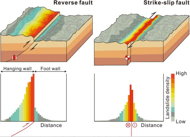
In a simply wonderful paper just published in Reviews of Geophysics, which is open access, Fan et al. (2019) review the literature on chains of geologic hazards arising from large earthquakes, with a focus on the Ch-Chi and Wenchuan earthquakes. The body of literature is huge, so this has been a monumental task, but the result is a paper that is rich in detail and nuance. I could write in detail about various aspects of it, but here I will focus on just one element. Many studies have considered the distribution of landslides across the landscape, in particular in relation to proximity to the surface expression of the fault that ruptured. For example, we have looked carefully at this effect for the Kaikoura earthquake (see Massey et al. 2018), and in general it is well established that proximity to the fault is a key factor controlling the likelihood of landsliding. Fan et al. (2019) summarise this effect in a very powerful diagram, showing the ways that the type of faulting changes the distribution:-
.

Chains of geologic hazards: the distribution of landslides triggered by earthquakes. Diagram from Fan et al. (2019)
.
The diagram very neatly summarises the key effects that drive the chains of geologic hazards –
- Proximity to the fault is the key spatial control on landsliding;
- The effect varies according to the type of faulting observed;
- For reverse faults, the majority of the landslides occur on the hanging wall block, with comparatively few on the footwall side;
- For reverse faults, the area affected by landslides can extend long distances from the surface expression of the fault on the hanging wall side;
- For strike-slip faults, the landslides tend to be more evenly distributed across the fault, with the area affected by landslides extending shorter distances from the surface expression of the fault.
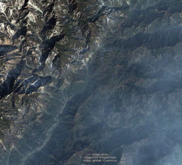
This is a complex pattern that the diagram summarises well. The image below shows a part of the area affected by the 2008 Wenchuan earthquake, which was primarily a reverse faulting event. The landslide distribution illustrates the point made by Fan et al. (2019) elegantly:
.

Chains of geologic hazards: landslides triggered by the 2008 Wenchuan earthquake. The fault runs SW-NE across the image, with the hanging wall block on the northwest side. Note the difference in landslide density in the north west compared to the south east. Image from Google Earth.
I am sure that the diagram from Fan et al. (2019) will appear in numerous lectures in the future.
The paper has many other insights into the chains of geologic hazards from large earthquakes. It is an important and interesting contribution that will become a classic.


 Dave Petley is the Vice-Chancellor of the University of Hull in the United Kingdom. His blog provides commentary and analysis of landslide events occurring worldwide, including the landslides themselves, latest research, and conferences and meetings.
As the area affected by the strike slip fault may not be ruptured in more pronounced way during the quake could’ve been revived of the after shocks which indicated that slides generated in shorter distance from the surface expression of the fault line .
Thrust ZONES/ reversefault area more weak seismically meaning vulnerabilities in the risks of huge amount of land slides; which is evident as mentioned in the the article
Photo of the study field.
Thank you very much for featuring our work. We are deeply grateful!
Best wishes,
Gianvito Scaringi
Hanging wall zone of the reverse fault ( thrust zone ) more unstable may be tectonically (presumably )hence more landslide susceptible after the triggering of a quake event.