27 June 2019
Mount Iliamna: a large landslide in Alaska on 20th June 2019
Posted by Dave Petley
Mount Iliamna: a large landslide in Alaska on 20th June 2019
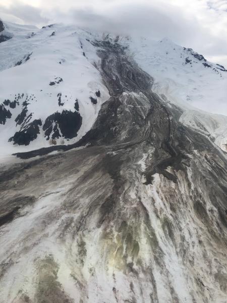
A very large landslide occurred on the flanks of Mount Iliamna, a volcano located in Alaska, on 20th June 2019. The landslide has been described by the Alaska Volcano Observatory, who have posted a number of images of the aftermath. The best of these was taken by Loren Prosser on the day after the landslide:-

The large landslide on the flanks of Mount Iliamna on 21st June 2019. Image by Loren Prosser, posted by the Alaska Volcano Observatory.
.
The caption for the image is as follows:
Photo of Red Glacier avalanche that occurred on 6/21 ~00:05 UTC (6/20 ~4:05 pm AK). Description from the photographer: “attached pics from a fly by this past Friday evening. The slide appeared a few days old at that point, and seemed to originate near the summit. The slide & debris are visible from across the inlet now as well. Debris field approx 2+ miles wide & the toe. Pretty impressive slide altogether!”
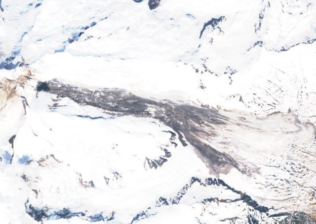
The landslide has been captured by a Sentinel 2 satellite image that is available via the Sentinel Hub:-

A Sentinel 2 image, collected on 25th June 2019, showing the Mount Iliamna landslide. Image via Sentinel Hub Playground.
.
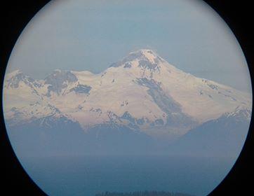
The landslide appears to be in the order of about 6 km in length, and over 2 km wide at the toe. This image, also via the Alaska Volcano Observatory, and taken by Dennis Anderson on 22nd June 2019, gives a better impression of the scale of the event:-

The Mount Iliamna landslide. Image collected by Dennis Anderson and posted online by the Alaska Volcano Observatory.
.
The caption for this image states:
Rockslide on Iliamna volcano on 6/21/2019. This image was taken around 11:00 am on 6/22/2019 by Dennis Anderson from Diamond Ridge NW of Homer using a tablet at the eyepiece of some 11×80 binoculars with a 4.5 degree field of view. This might have occurred sometime in the past 12-48 hours as Illiamna was obscured by clouds most of yesterday.
The trigger of this landslide is not clear, but Alaska has experienced a series of very large landslides (often in the early part of the summer) in recent years, including Juneau, Icy Bay / Tyndall Glacier, Glacier Bay / Lamplugh, and Sitka. There is good evidence that this is associated with climate change.


 Dave Petley is the Vice-Chancellor of the University of Hull in the United Kingdom. His blog provides commentary and analysis of landslide events occurring worldwide, including the landslides themselves, latest research, and conferences and meetings.
The Sentinel-hub Playground URL for Mount Iliamna is https://apps.sentinel-hub.com/sentinel-playground/?source=S2&lat=60.02566951461037&lng=-152.99406051635742&zoom=12&preset=1-NATURAL-COLOR&layers=B01,B02,B03&maxcc=20&gain=0.2&gamma=0.5&time=2018-12-01%7C2019-06-28&atmFilter=ATMCOR&showDates=false
I’ve been studying earthquake and volcanic activity in the Alaska illusion Cook inlet area for a couple of years. This is very fascinating and the second image really shows that it was quite a big deal. If a landslide occurred at this volcano in the wrong place couldn’t it cause us tsunami and injure people similar to St Augustine back in time?