
7 September 2021
Jeori: a large highway landslide in Shimla district, Himachal Pradesh
Jeori: a large highway landslide in Shimla district, Himachal Pradesh
Yesterday (6 September 2021) a large landslide blocked National Highway 5 at Jeori in Shimla district, Himachal Pradesh in northern India. The landslide, which occurred at about 9 am, did not cause any casualties. This landslide is particularly interesting as it was caught on video from at least four different angles. The first was collected by someone located on the road itself, fortunately a safe distance away:
A landslide occurred near Jeori , #Shimla, #Himachal Pradesh, #India. No casualties reported. Video source: V.S. Negi. pic.twitter.com/k05o5EdBBq
— Vipin Kumar (@chauhanVKgeo) September 6, 2021
.
Meanwhile, another video was captured from a greater distance away, which provides less detail but gives a better appreciation of the process:-
Earlier today, a massive landslide occurred at Jeori in Himachal Pradesh's Shimla. The Shimla-Kinnaur national highway has since been closed. No loss of life reported yet. #Landslide #HimachalLandslide
Video source: @TOIChandigarh pic.twitter.com/YLzS3bKGKA
— The Weather Channel India (@weatherindia) September 6, 2021
.
And a third video was captured from the other end of the road:-
Shimla-Kinnaur national highway closed after massive landslide at Jeori. No loss of life reported.#Shimla #Kinnaur #landslide #nationalhighway pic.twitter.com/d1q5MDFf4k
— Rajinder S Nagarkoti रजिन्दर सिंह नगरकोटी (@nagarkoti) September 6, 2021
.
And a further video was captured further along the road:-
Today's Landslide video Near Jeori , Shimla . NH 5 blocked (Shimla-Kinnaur)
Vc- Deepak Passan#Himachallandslide #HimachalPradesh #Shimla #Kinnaur pic.twitter.com/ilaAfHwsf5
— Weatherman Shubham (@shubhamtorres09) September 6, 2021
.
I am not sure I’ve seen a landslide captured from four different perspectives before, so this is a cool event.
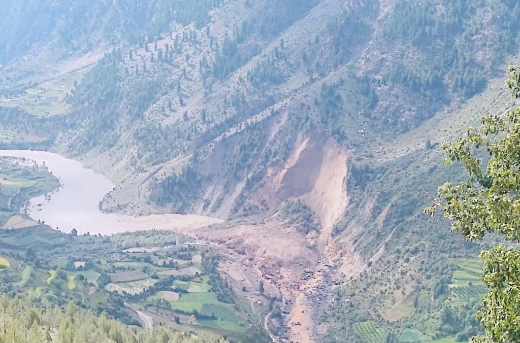
Photographs of the site in the aftermath of the landslide site, extracted from one of the videos, suggest that the road was on an artificial bench with an unsupported cut slope above:-
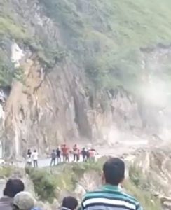
The site of the landslide close to Jeori in northern India. Still from a video posted to Twitter
.
Note the small pile of debris on the road before the main collapse occurred. This indicates that there was some precursory deformation, which presumably provided warning of an impending collapse.
The landslide appears to have occurred in dry weather, but we are in the tail end of the monsoon, which may have played a role in progressively weakening the hillslope.
Works are under way to reopen the road. As usual, these operations carry considerable risk.
6 September 2021
Catoca mine in Angola – using satellite imagery to understand recent events
Catoca mine in Angola – using satellite imagery to understand recent events
According to Wikipedia, Catoca mine in Angola is the fourth largest diamond mine in the world. Located at -9.399, 20.301, it consists of a big open cast pit and a very large tailings storage area.
Last month, CRREBaC released information about a set of very significant pollution events in the rivers of Angola and Congo, linked to mining in Angola. Reports have included the pollution of hundreds of kilometres of the river system, deaths of fish and hippos and, in some cases, suggestions of up to twelve fatalities. Detailed information to evidence these huge losses is lacking, but there is little doubt that serious pollution occurred.
Whilst this blog is about landslides, I have very often written (and indeed campaigned) about the scandalously poor management of tailings in the mining industry, and I have highlighted several major tailings dam failures. My interest in the events in Angola and Congo results from concerns that the events might have been one or more tailings dam collapses.
One of the candidate sites for the events in Angola is the facility at Catoca, and indeed the operators have reportedly admitted that a release did occur, but only of water and sand.
This is a satellite image of the Catoca facility collected by Planet Labs on 21 July 2021:-
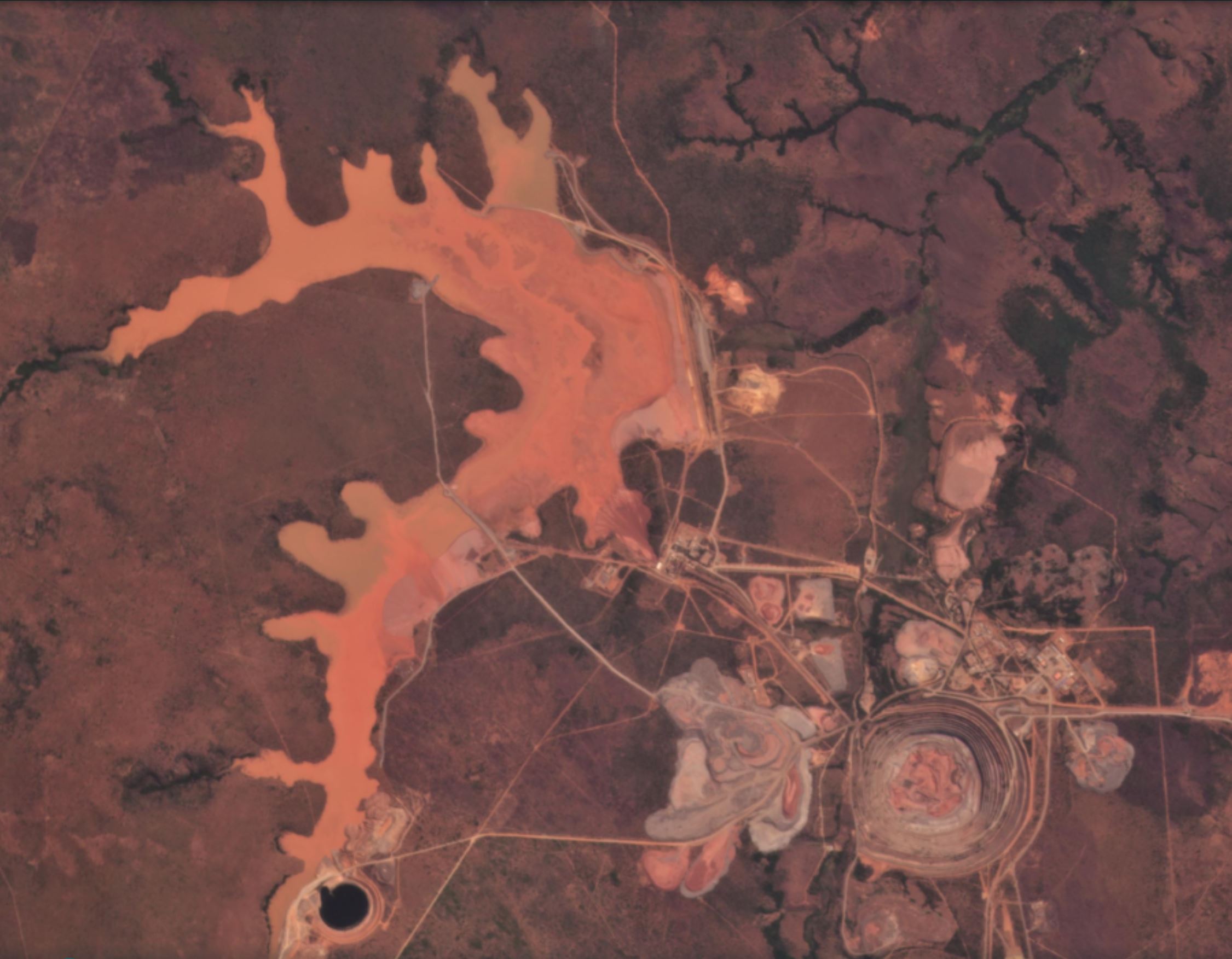
The Catoca diamond mine on 21 July 2021. Image copyright of Planet Labs, used with permission.
.
The pit is in the bottom right hand corner, the tailings facility in the huge orange area on the left side of the image. The tailings dam is located just above the centre of the image, orientated NNW-SSE. There is no evidence of any problem in this image.
The first sign of change appears in the image of 24 July 2021. The change is subtle but significant:-
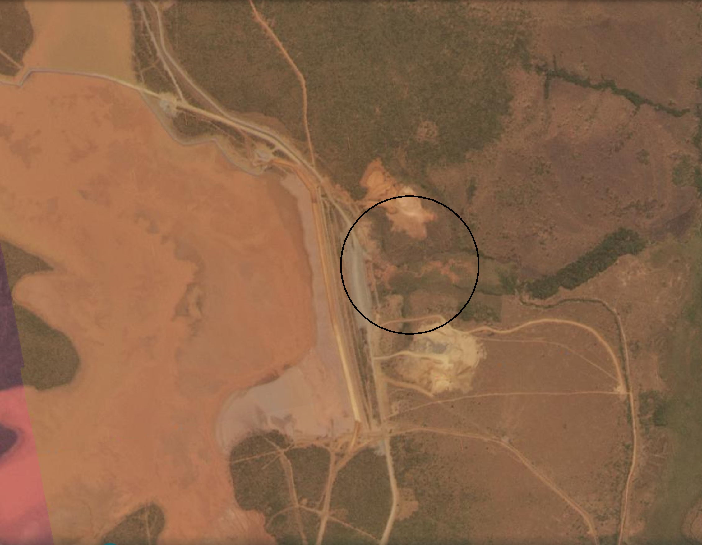
Pollution downstream of the Catoca diamond mine on 24 July 2021. Image copyright of Planet Labs, used with permission.
.
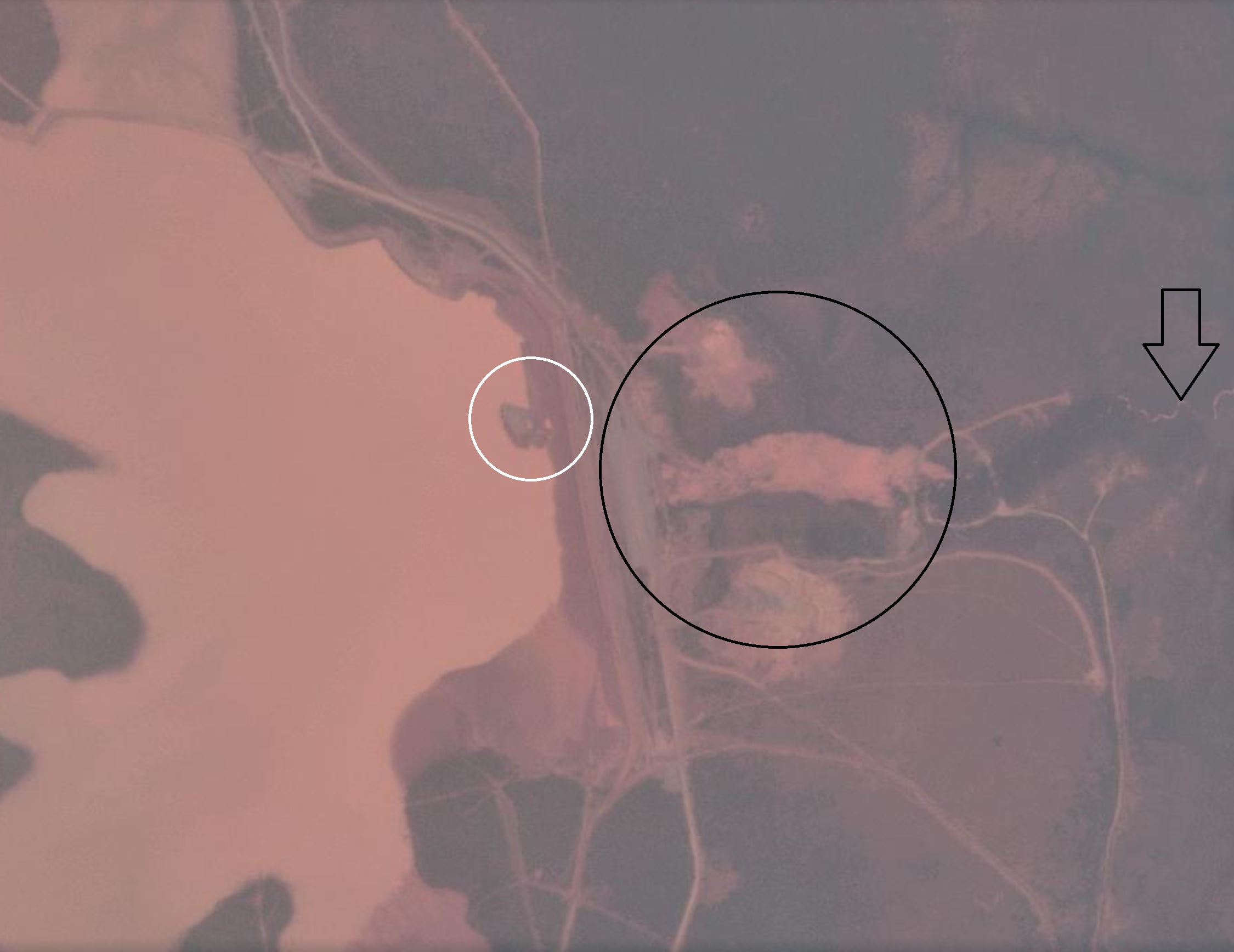
I have put a black circle around some clear pollution on the downstream side of the tailings dam. Note that the tailings dam was intact (and remains so). A day later the problems had become very much worse:-
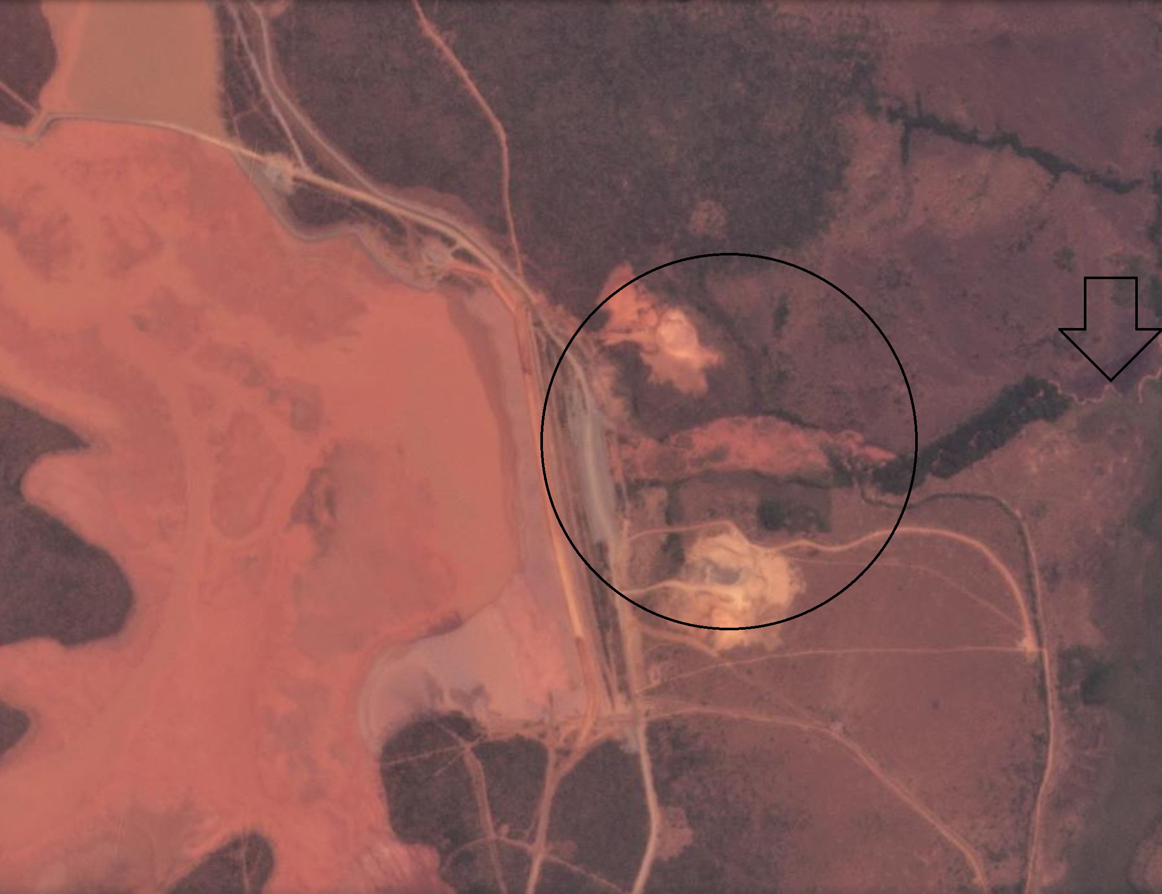
Pollution downstream of the Catoca diamond mine on 25 July 2021. Image copyright of Planet Labs, used with permission.
.
By 25 July 2021 a large plume of pollution had appeared on the downstream side of the tailings dam (highlighted with a circle again). The had entered the watercourse, which was now showing very clear signs of pollution (highlighted with an arrow).
The situation today, a few weeks later, is interesting:-
Pollution downstream of the Catoca diamond mine on 5 September 2021. Image copyright of Planet Labs, used with permission.
.
The plume has developed considerably , although it has not enlarged significantly (black circle). The polluted watercourse is very clear. There is clear evidence of works around the plume (new roads for example) and on the upstream side of the dam (white circle).
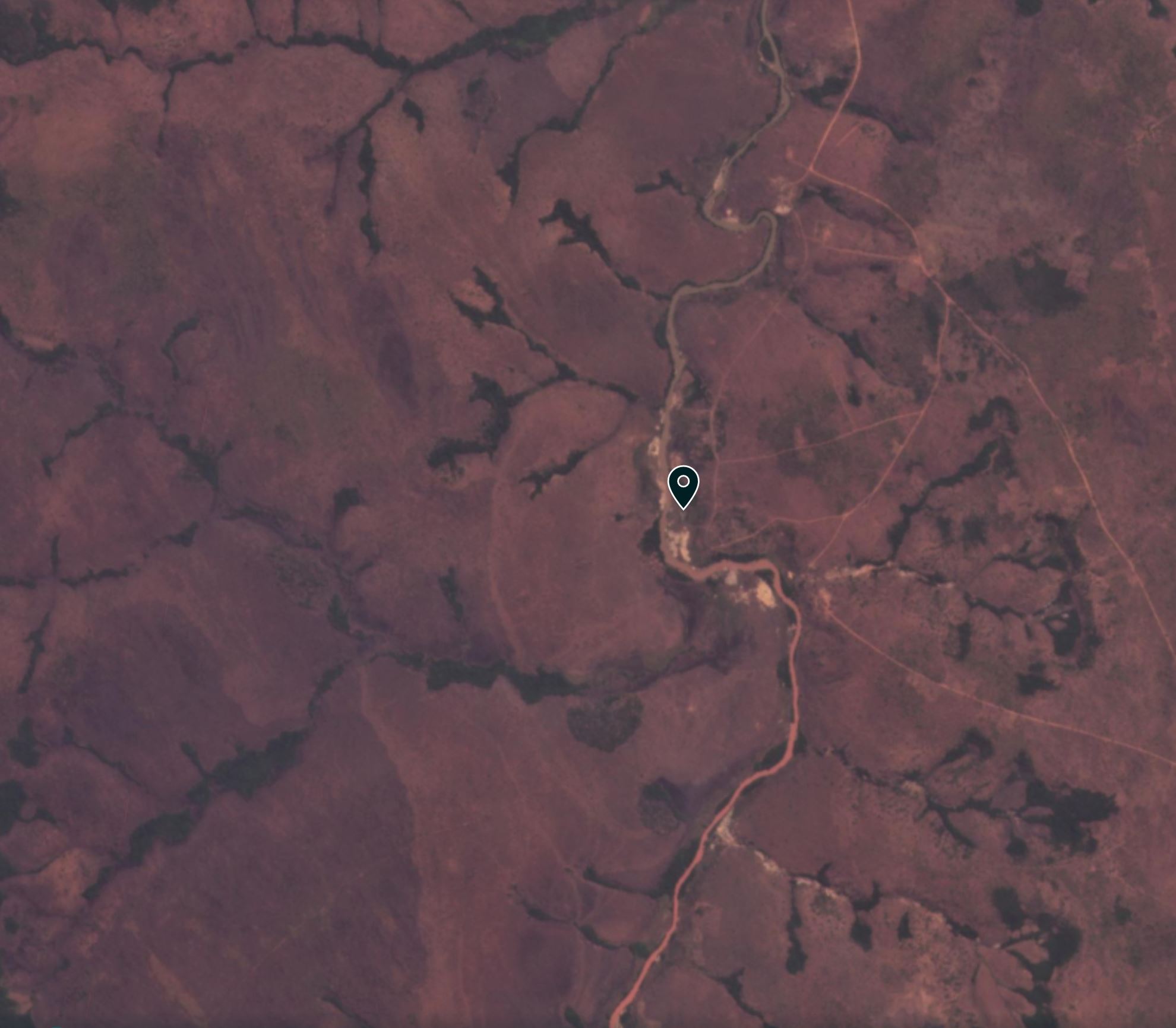
From the images above the pollution might not at first sight look serious, but satellite images downstream might tell a different story. This image was collected on 25 July 2021 at about 8:56 UT, downstream of Catoca at -9.127, 20.346:-
The front of the pollution downstream of the Catoca diamond mine on 25 July 2021. Image copyright of Planet Labs, used with permission.
.
The river is flowing from the south to the north. In the lower part of the image the river is bright orange with pollution. In the northern part of the image the river is unpolluted. The marker, at -9.127, 20.346 is the approximate front of the pollution moving downstream from Catoca. Note the profound change in the water as the pollution front moves through.
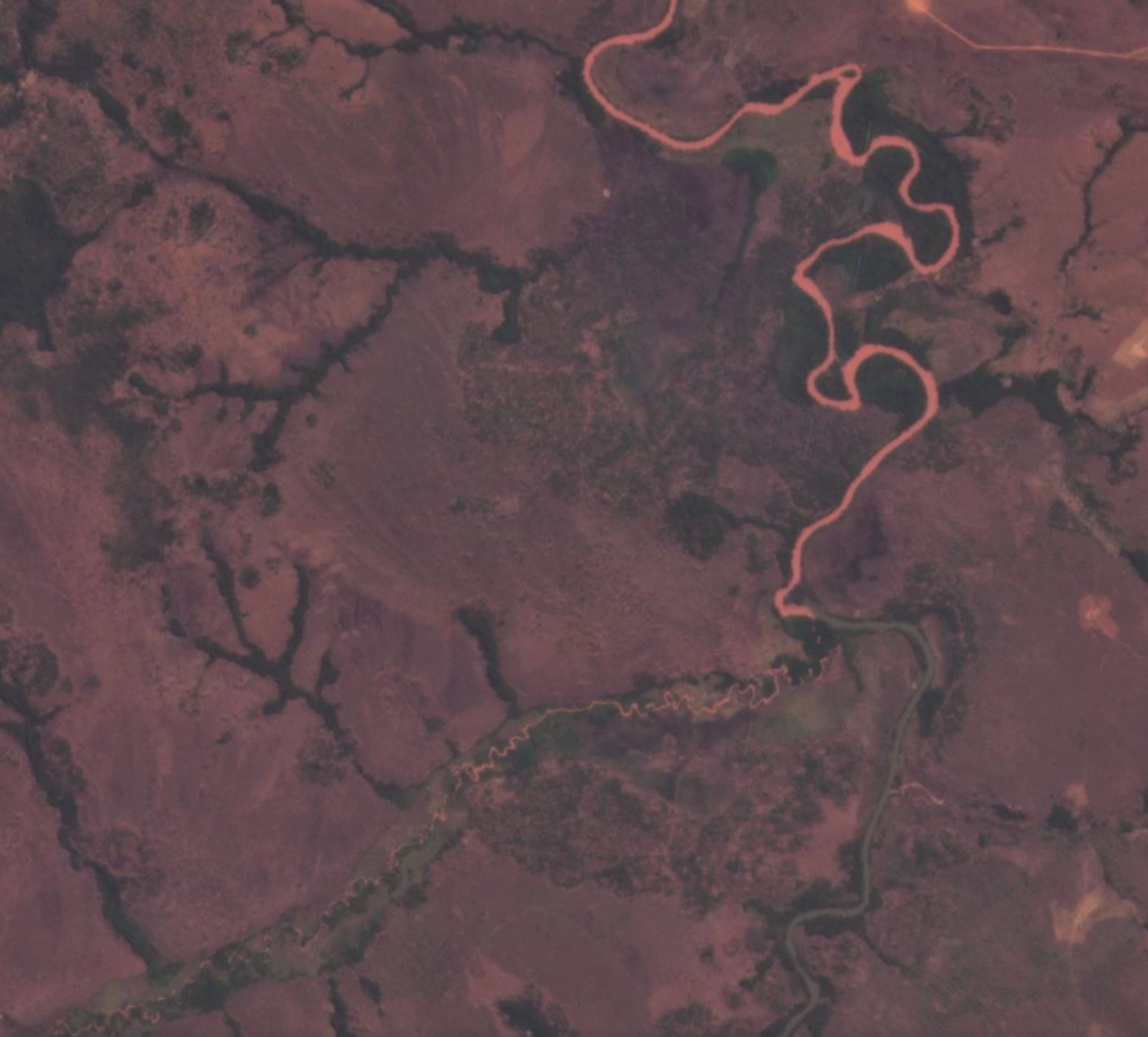
This is even more profoundly illustrated in the image below. The small tributary from Catoca flows in from the southwest. It meets the main channel, flowing from south to north. Note the huge change in water quality from this point onwards:-
The passage of pollution downstream of the Catoca diamond mine on 25 July 2021. Image copyright of Planet Labs, used with permission.
.
This location is -9.309, 20.362.
According to the New York Times article:-
In a statement last month, the company admitted that there had been a “rupture in the pipeline that works as a spillway.”
The satellite images are consistent with this as the source of the pollution, although the ecological damage looks to be more severe than some have suggested.
However, there is an anomaly. The CRREBaC report indicates that substantial pollution was first seen in the rivers of Angola from 15 July 2021:
On the basis of the Sentinel images published by Visio Terra (Equipe Sentinel Vision, EVT919, 2021) and our preliminary investigations from riparian communities, this pollution has been observed since 15 July 2021 from the source in the Angola part of the basin and would have taken 15 days to reach the city of Tshikapa, and 21 days for the city of Ilebo in the Democratic Republic of the Congo (DRC).
The pollution observed on 15 July 2021 does not seem to have come from Catoca according to the images, which suggests a second serious event occurred in a different mine in the area.
.
Reference
Planet Team (2021). Planet Application Program Interface: In Space for Life on Earth. San Francisco, CA. https://www.planet.com/
3 September 2021
Landslides from the 14 August 2021 earthquake in Haiti
Landslides from the 14 August 2021 earthquake in Haiti
On 14 August 2021 a M=7.2 earthquake struck Haiti to the west of the capital Port-au-Prince. Whilst this event affected an area that is less densely populated than was the case for the 2010 event, it still killed over 2,000 people.
The earthquake affected an area that is mountainous at a time of year in which rainfall is common, so landslides were inevitable. In a post soon after the earthquake, NASA highlighted that substantial numbers of landslides had indeed happened.
The image below shows the landscape around Pic Macaya National Park, which was close to the fault that ruptured to trigger the earthquake in Haiti. The landscape is densely vegetated and mountainous:-
The area around Pic Macaya National Park that was affected by the 14 August 2021 earthquake in Haiti. Image copyright Planet Labs, used with permission, dated 10 August 2021, four days before the earthquake..
.
Some landslides are visible, particularly in the central south of the area and to the east. However, the image below shows the same area after the earthquake:
The area around Pic Macaya National Park that was affected by the 14 August 2021 earthquake in Haiti. Image copyright Planet Labs, used with permission, dated 29 August 2021, about two weeks after the earthquake.
.
The image shows a very dramatic increase in the number of landslides, particularly in the catchments in the centre of the image. The satellite image below provides more detail of some of these landslides:-
Detail of landslides in Pic Macaya National Park after the 14 August 2021 earthquake in Haiti. Image copyright Planet Labs, used with permission, dated 29 August 2021, about two weeks after the earthquake.
.
There are hundreds, possibly thousands, of landslides in the images, with densities approaching those seen in areas of the Wenchuan earthquake in China, although over a smaller area. Most of the images appear to be shallow disrupted slides, as is usually the case in such events.
The area was affected by a large rainstorm two days after the earthquake, when Tropical Depression Grace crossed Haiti on 16 August 2021. It is likely that the landslides in the images is a consequence of the combination of the earthquake and mobilisation of slope materials and landslide debris in the storm.
It is not clear how many people were killed by landslides in the 2021 Haiti earthquake, but the numbers are likely to have been substantial.
.
Reference and acknowledgement
Planet Team (2021). Planet Application Program Interface: In Space for Life on Earth. San Francisco, CA. https://www.planet.com/
1 September 2021
George County: a drone video of the site of a fatal landslide triggered by Hurricane Ida
George County: a drone video of the site of a fatal landslide triggered by Hurricane Ida
The landfall of Hurricane Ida across the southern USA earlier this week caused high levels of rainfall, inducing flooding and landslides. In terms of mass movements, one of the most significant events occurred in the Benndale community in George County in Mississippi, where a substantial failure destroyed a section of MS26. The landslide had substantial consequences – it killed two people and injured a further 10, three of them critically.
The SunHerald has a detailed article about the event, and has published a drone video of the aftermath. The site is quite interesting, as this overhead view shows:
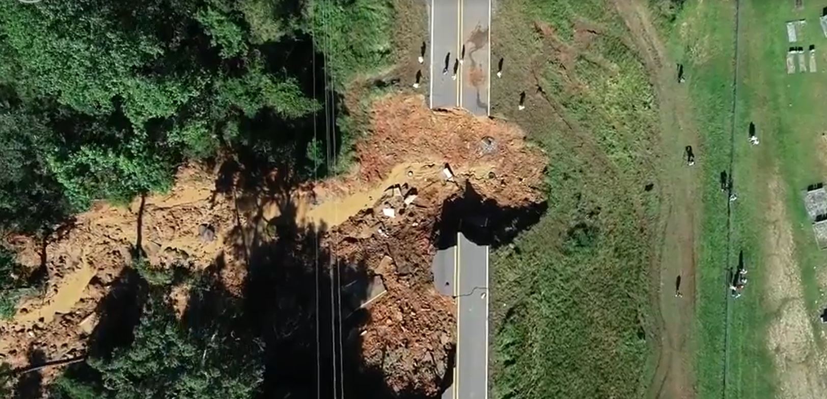
The fatal landslide in George County, Mississippi. Image taken from a drone video posted by the SunHerald. Drone video by Travis Long.
.
The view below, also from the drone video, provides an understanding of the form of the landslide:
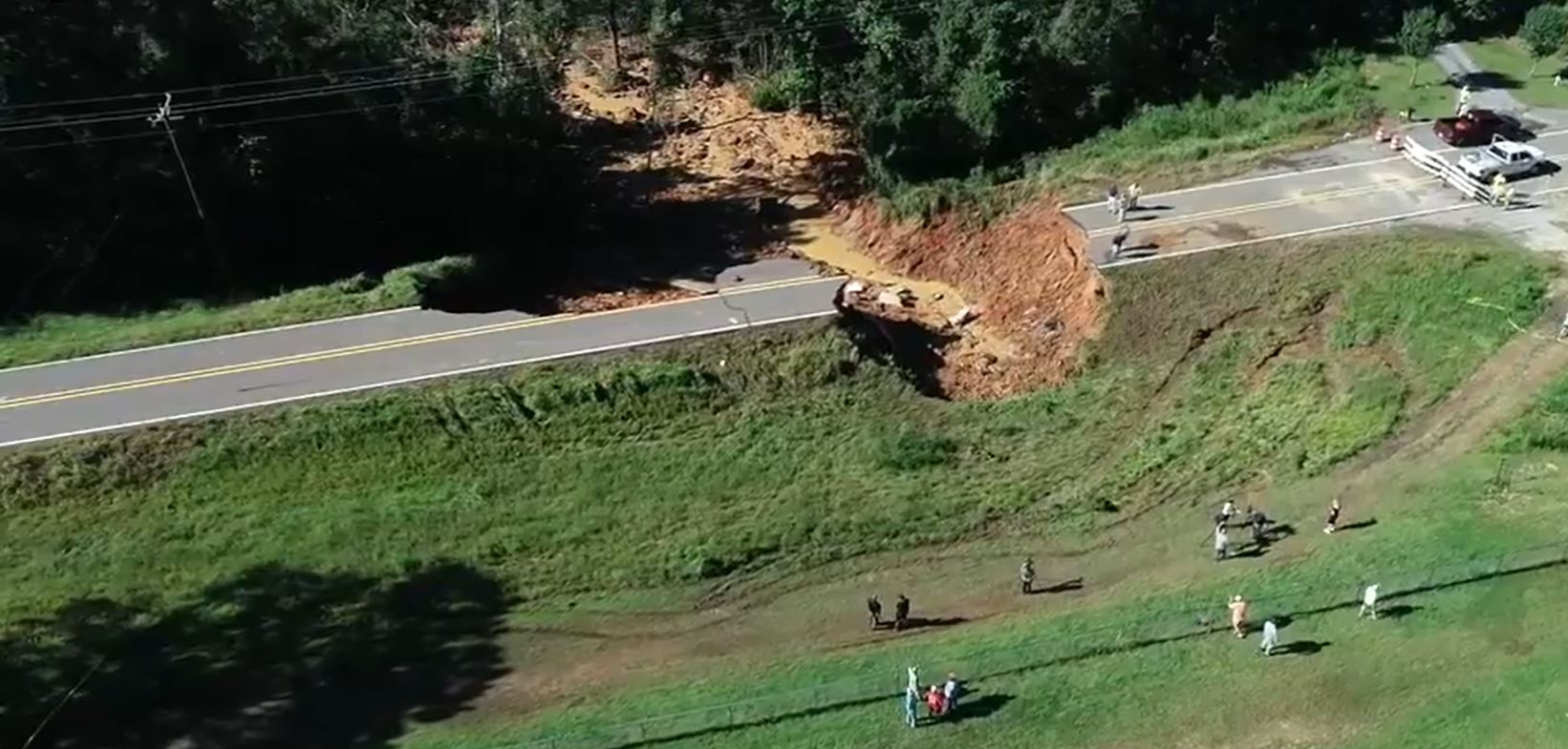
An oblique view of the fatal landslide in George County, Mississippi. Image taken from a drone video posted by the SunHerald. Drone video by Travis Long.
.
The SunHerald article provides some information about the landslide:-
“It is a slide, which means the ground under the roadway and embankment was super-saturated and we can tell right now that’s what caused the slide,” said Kelly Castleberry, district engineer for the Mississippi Department of Transportation. “The ground liquified and it spread several hundred feet to the south.”
The road appears to be on embankment, which has failed.
13 August 2021
Nalda: a valley-blocking landslide in Himachal Pradesh, India
Nalda: a valley-blocking landslide in Himachal Pradesh, India
This morning (Friday 13 August 2021) a major landslide occurred near to the village of Nalda, in Lahaul and Spiti district in Himachal Pradesh, northern India, blocking the Chenab River. The landslide event itself was captured in a video that has been posted to Youtube:
.
The landslide has left a large barrier across the Chenab River close to Nalda. The image below, from Tribune India, provides an overview of the situation:
The valley blocking landslide close to the village of Nalda in Himachal Pradesh in northern India. Image from Tribune India
.
This is not likely to remain breached for long given the topography of the land and the form of the barrier – indeed some reports suggest that some flow has been re-established. But even a few hours of impounded water has the potential to generate a substantial local flood, so there is a substantial hazard for villages downstream.
Note the very clear planar structures in the landslide scar. The failure is clearly defined by two existing joints or faults, meeting with a c.90 degree angle. Note also the landslide scar immediately to the left of the landslide scar. That must also have been a substantial failure event.
This landslide comes on the back of a significant landslide in India on Wednesday, when a slope above a road in India collapsed, burying several vehicles including a bus. Recovery operations continue at the site, but at the time of writing 15 bodies have been recovered. There are fears that there may be substantially higher levels of loss. The Indian Express reports that Chief Minister Jai Ram Thakur has indicated that up to 60 people were feared trapped under the debris at the time of the accident. Rescue operations are being hampered by ongoing instability on the slope.
5 August 2021
Understanding the recent monsoon landslides in Maharashtra, India
Understanding the recent monsoon landslides in Maharashtra, India
Last month, heavy rainfall in the Maharashtra area of India triggered a number of deadly landslides. The most serious of these occurred at Taliye village, where at least 53 people, and possibly as many as 84 people, were killed. However, this was not the only substantial landslide; there were at least another six fatal landslides, which took an additional 50 lives.
My friends at South Asia Network on Dams, Rivers and People (sandrp.in) have done a heroic job in collating information about these landslides, their locations and impacts. I have used their information to produce a quick Google Earth map of the landslide locations:
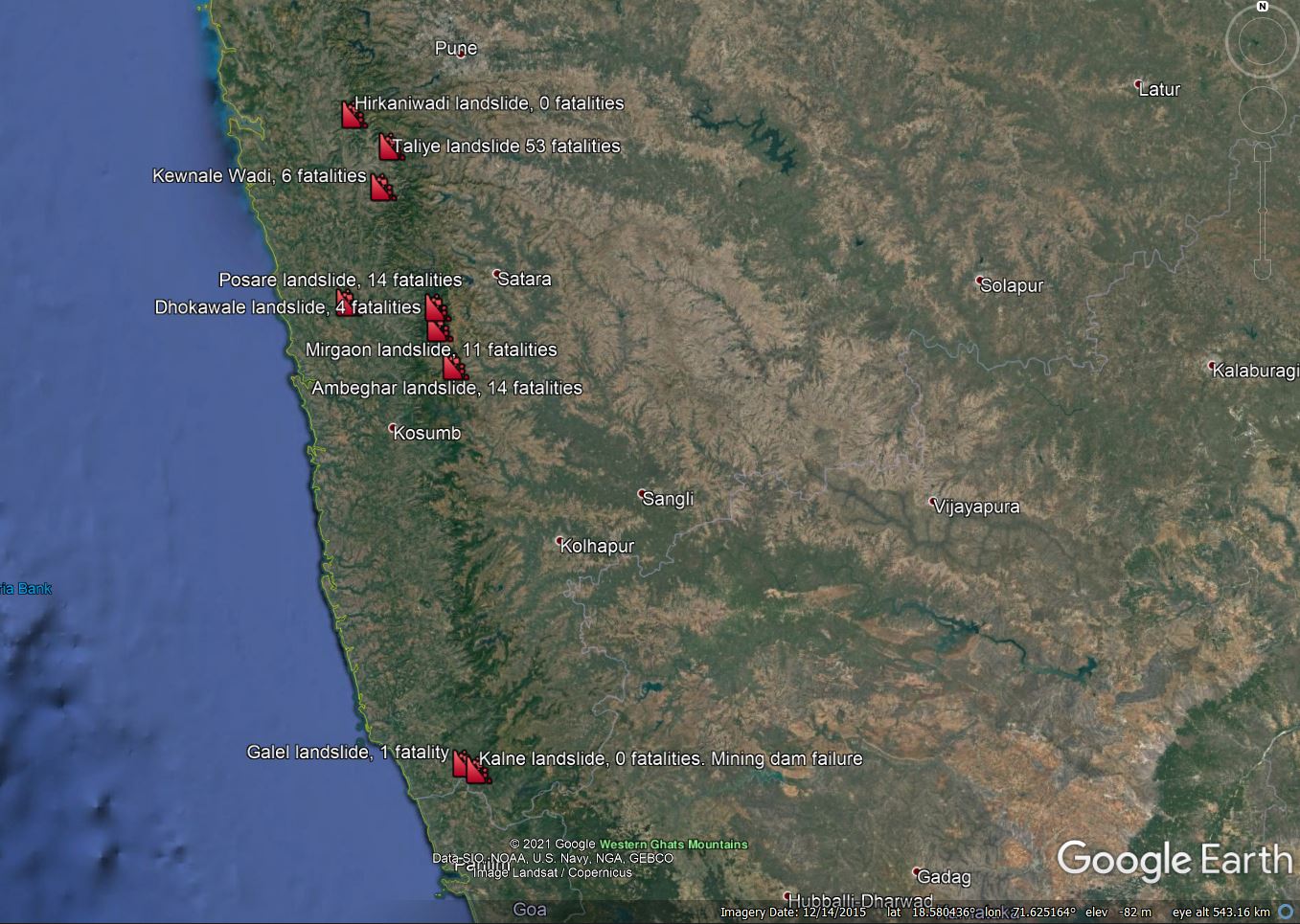
A map of the landslides in the Maharastra area on India in late July 2021. Map based on information from Parineeta Dandekar of South Asia Network on Dams, Rivers and People.
.
I have included two significant non-fatal landslides as well. It is interesting to compare the landslides to a map of the rainfall. The map below is a 3 day rainfall total for the period ending 24 July 2021 (the Taliye landslide occurred on 22 July 2021), from the NASA Global Precipitation Measurement mission:
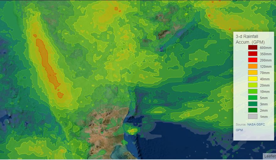
3 day accumulated rainfall for central India. This is GPM IMERG 3-day data from NASA, plotted using the visualizer.
.
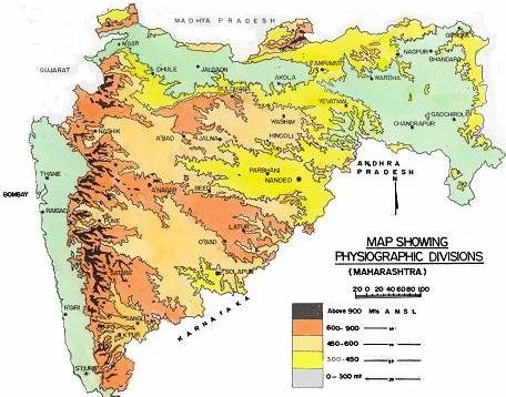
The cluster of high rainfall totals exactly where the landslides were triggered is clear. The map below (from Researchgate) shows the topography of Maharashtra:
The topography of Maharashtra, from Researchgate.
.
The map shows that there is higher elevation ridge running approximately parallel to the coastline. It is clear that the high rainfall totals reflect this ridge (presumably due to an orographic effect), and of course it also provides the topography for the landslides. The main landslide cluster is to the southeast of Mumbai (Bombay).
But why were there so many landslides? The answer may well lie, at least in part, in degradation of the environment. Removal of natural vegetation, cutting of slopes, quarrying and road building are taking a huge till across the upland areas of India (and indeed across the hilly parts of much of South Asia). As usual, in the aftermath of monsoon landslide disasters there is discussion about warning systems and suchlike (which in general have a very patchy success rate in rural settings in less developed countries). Although they can and do have a role, this is to miss the salient point, which is that we need to work on preventing increases in susceptibility as a priority, mainly through better management of slopes.
Climate change is going to exacerbate these problems at pace, as will continued damage to slopes. If we are to reduce these disasters, we need manage the slopes properly.
Acknowledgement
Many thanks to my friends at the South Asia Network on Dams, Rivers and People, and in particular Parineeta Deshpande-Dandekar, for help with the data in this post.
4 August 2021
A rockfall video from the Couloir du Gypaète in France
A rockfall video from the Couloir du Gypaète in France
With thanks to those who spotted this on Youtube, a very surprising rockfall video was posted online last week by Rémi Bourdelle, who was flying above the Couloir du Gypaète in France when a rockfall developed. The video provides an utterly unique perspective on rockfall processes. Take a look:-
.
My first reaction to this is of course wow! The video shows boulders bouncing down the gulley and then through the trees below. As noted previously the force of these rocks is extraordinary.
But the most surprising element of this video is the trajectory of the rock seen at the start of the video. Fortunately, this boulder (which appears to have been fragmenting) left a trail of dust that marks its path through the air:
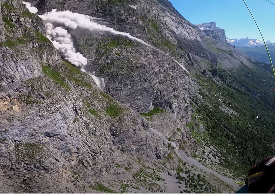
The trajectory of the boulder at Couloir du Gypaète in France. Still from a Youtube video by Rémi Bourdelle.
.
This is the sort of trajectory that is normally associated with fly rock from blasting rather than a rockfall. It is quite extraordinary; I have not seen this previously (have any readers?).
Presumably, the boulder struck an inclined surface, whilst travelling at a very high velocity, causing a ricochet that created this ballistic trajectory.
The other obviously possibility would be ejection during fracturing, but this seems less likely to me.
I’m not sure if this is a freak, or something that is quite common. Any views?
2 August 2021
Melamchi – satellite images and helicopter videos start to explain the catastrophic floods in Nepal
Melamchi – satellite images and helicopter videos start to explain the catastrophic floods in Nepal
On 14 June 2021 a huge debris flow and flood destroyed Melamchi in Nepal. The event was triggered by heavy rainfall, and as I noted a few days after the event, there is a very large landslide upstream of the village that might explain the surge that came down the valley. However, the event has been slightly mysterious, partly because satellite images have not been available of most of the area upstream of Melamchi. It is now clear that the event was more complex, and more concerning, than was initially obvious.
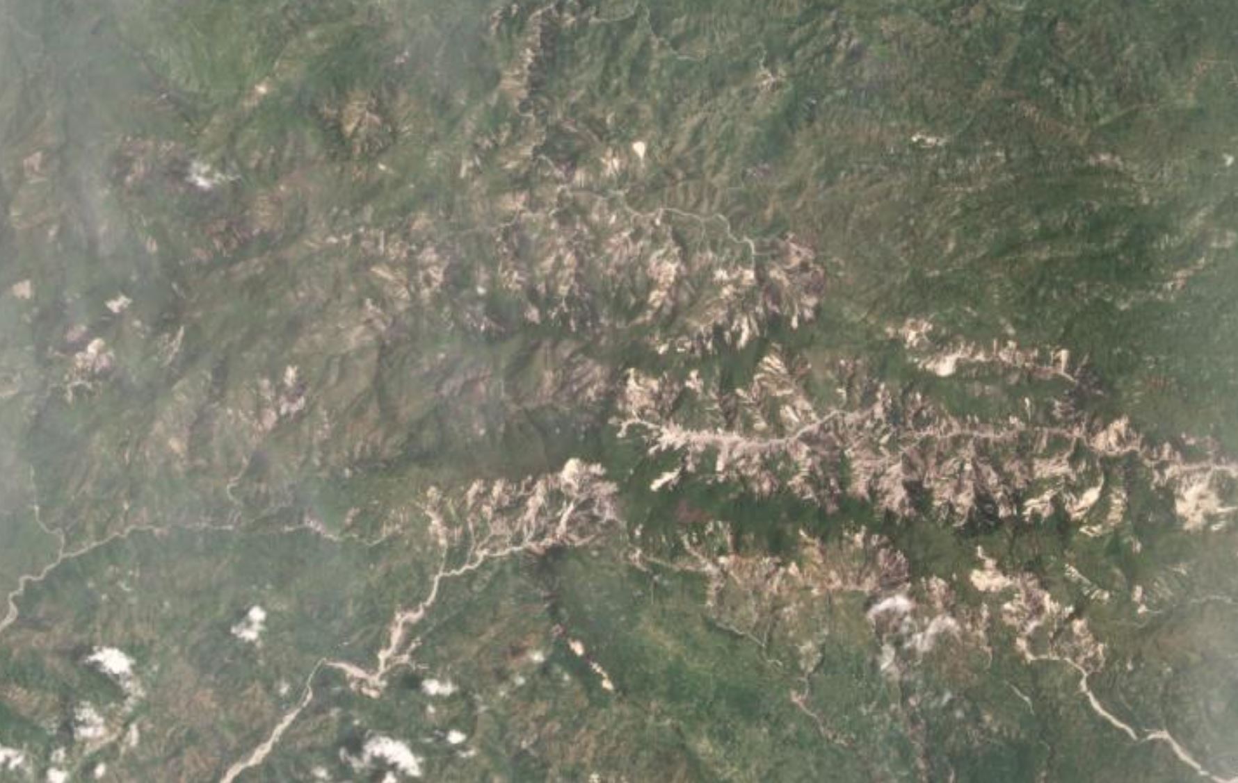
Satellite imagery is slowly becoming available – this is slow as the area is still covered in monsoon cloud most of the time. To understand this event we have to go right up to the headwater area in the high mountains. This is the site:-
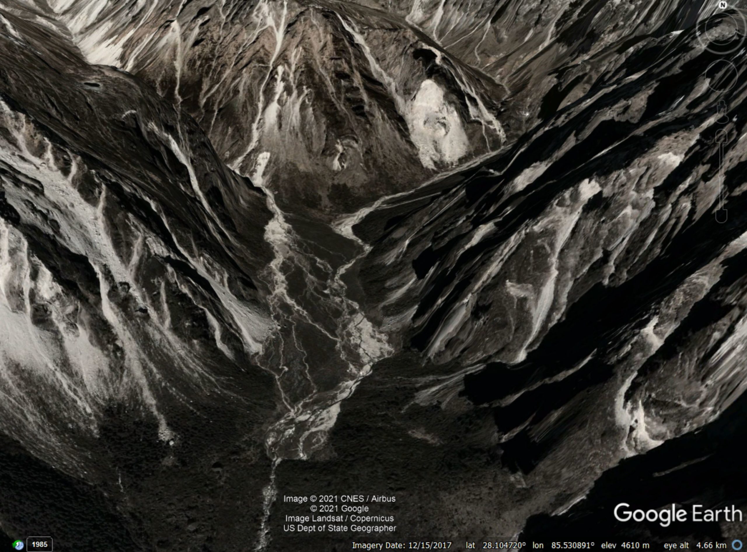
Google Earth image of the headwaters above Melamchi.
.
This is a very steep, very rugged terrain. Note in the centre of the image the large volume of sediment, partially vegetated, in the valley floor, trapped against some sort of barrier (very possibly an old landslide deposit).
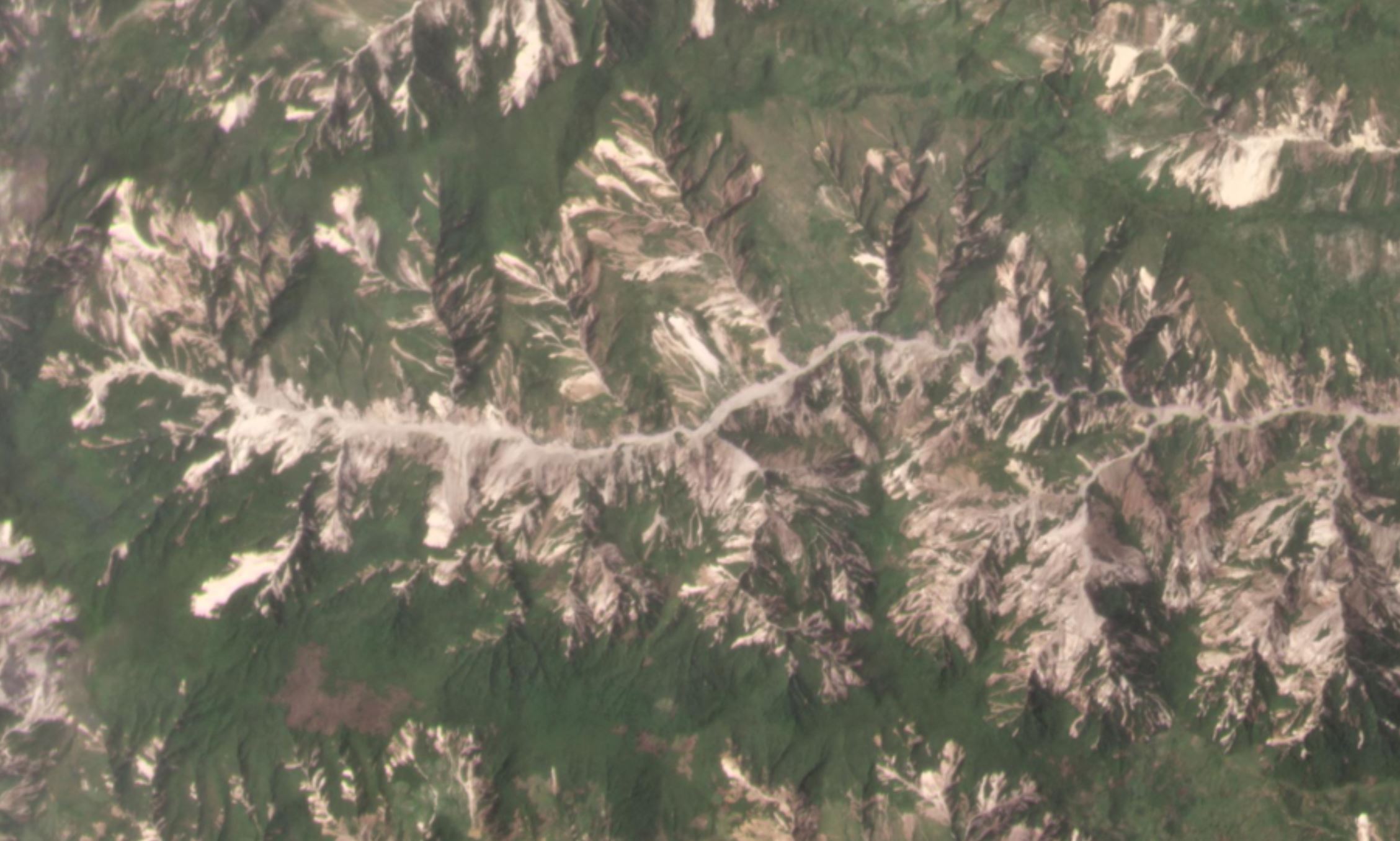
Planet Labs captured an image of the same area on 29 July 2021. This is not the best image, but the change is startling:
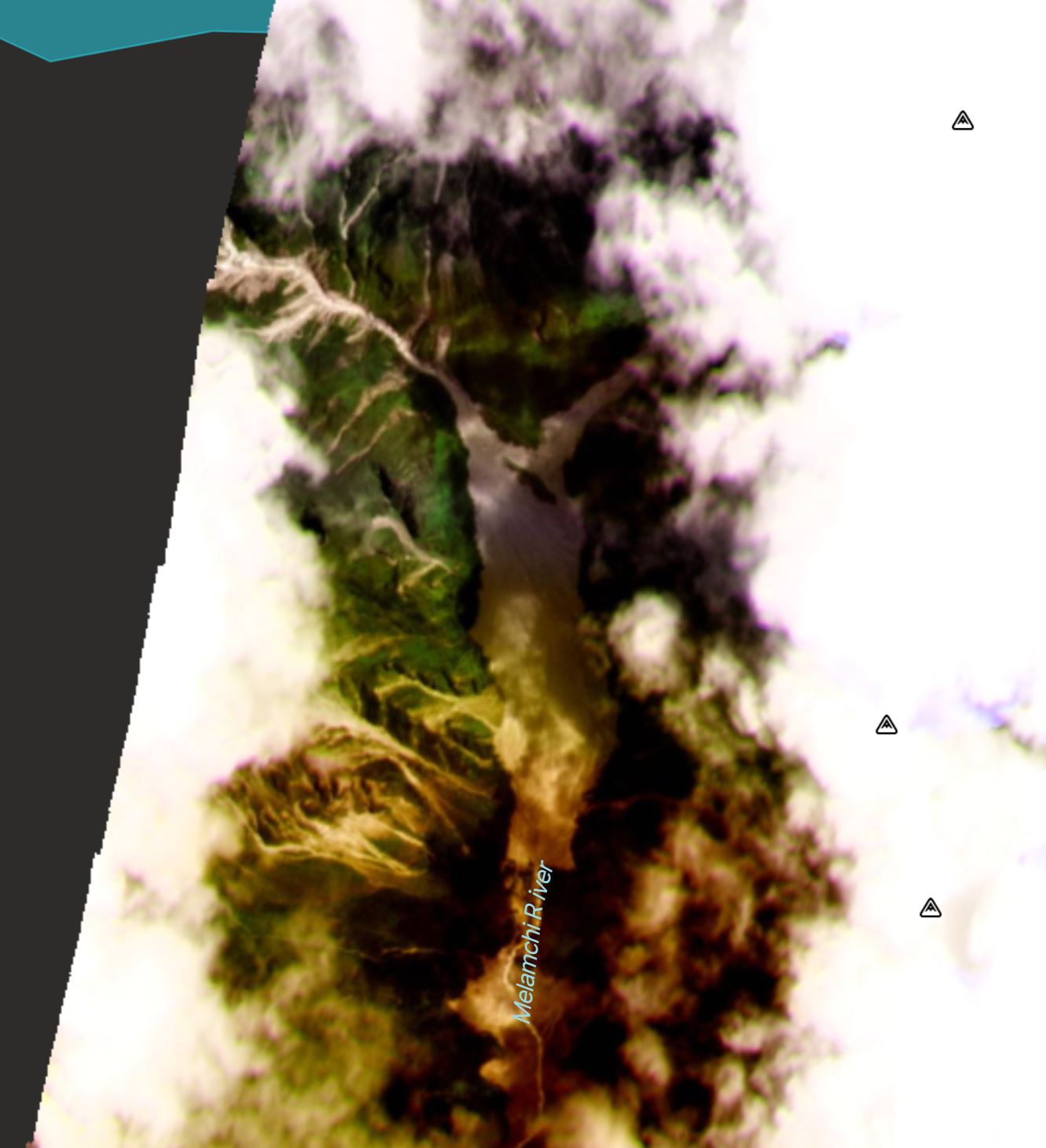
Satellite image of the headwaters area above Melamchi, captured on 29 July 2021. Image copyright Planet Labs, used with permission
.
Upstream of this area there are some landslides, most notably from the valley to the northwest. But there appears to be huge mobilisation of the sediment trapped behind the barrier.
Further insight comes from a pair of Tweets yesterday by Shiva Dahal (@dahalshivaji), which included both photographs and a startling video of the site:-
https://twitter.com/dahalshivaji/status/1421754169904357376
.
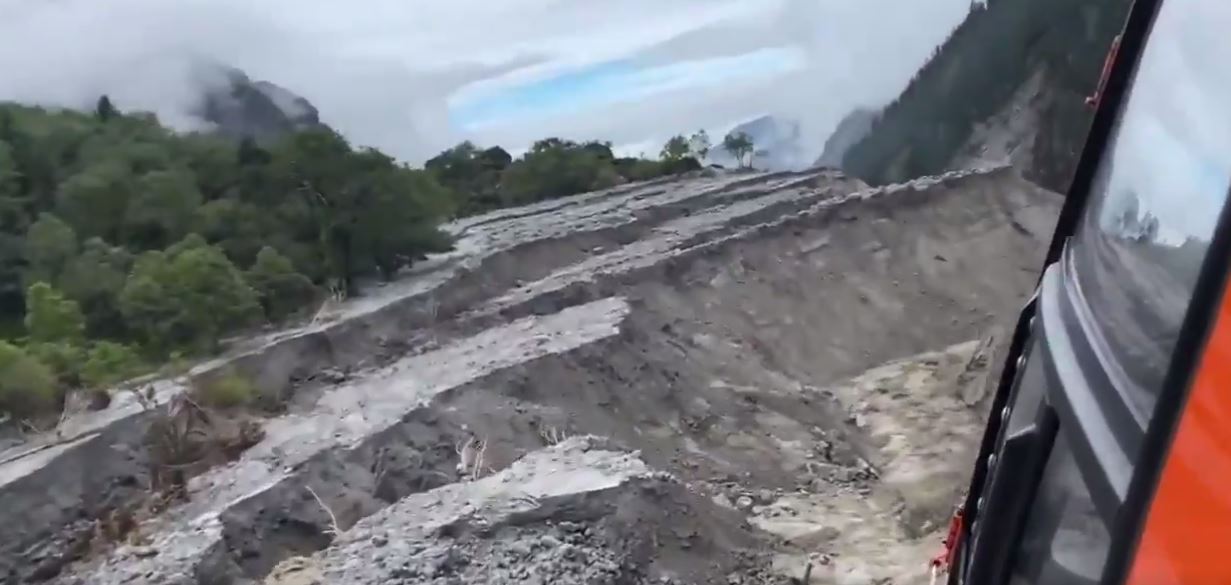
The lower left image shows this area of sediment, clearly dramatically mobilised by the flood. The helicopter video captures this even more clearly:-
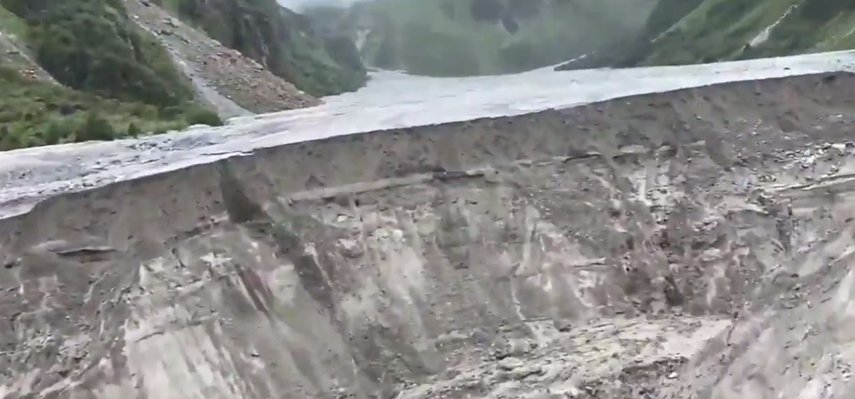
The collapsing front edge of the sediment deposit upstream of Melamchi. Still from a helicopter video posted to Twitter.
.
The view looking downstream is, if anything, even most dramatic:-
The collapsing front edge of the sediment deposit upstream of Melamchi. Still from a helicopter video posted to Twitter.
.
My interpretation is that this is effect the breach of an ancient landslide dam, which is now collapsing under successive rainstorm events. The sediment pile extends from about 2 km, and only a small proportion has mobilised to date.
The sediment pile is collapsing rapidly – the video even captures small collapses occurring – with big slumps developing, as seen in the second video. Downstream, a huge amount of erosion has developed, and the walls of the channel have collapsed extensively:
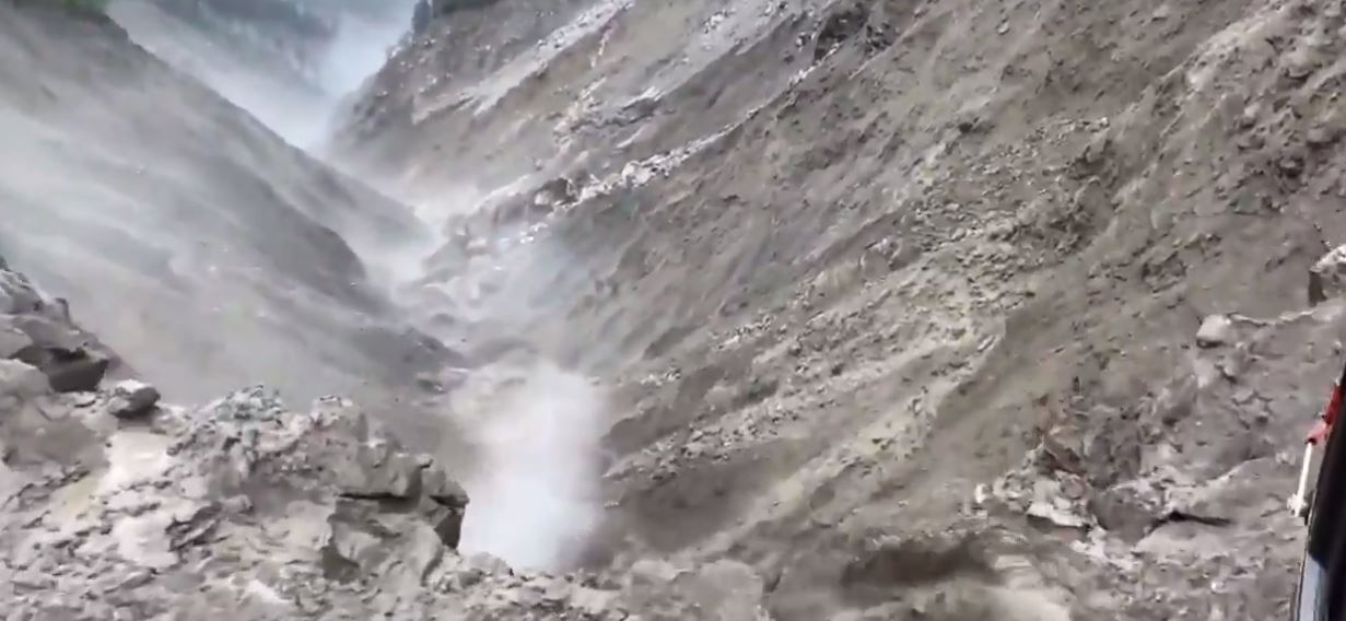
The deeply eroded channel upstream of Melamchi. Still from a helicopter video posted to Twitter.
.
Further downstream, as I noted in a previous post, there is a large landslide near to the village of Melamchigaon, but it appears that this was not the cause of the disaster:-
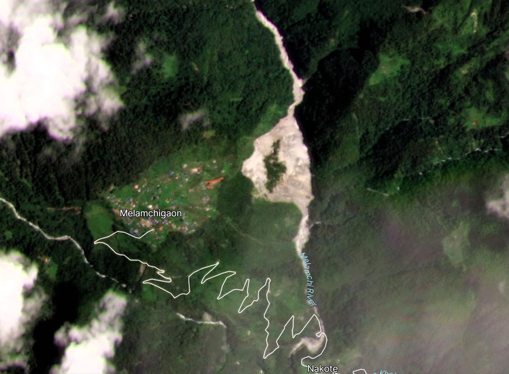
Satellite image of the landslide close to Melamchigaon. Image copyright Planet Labs, used with permission
.
These images are grim in terms of the safety of Melamchi. There appears to be a huge, unstable mass of sediment, undergoing collapse, upstream of the town. Heavy rainfall is likely to bring further major floods and debris flows, and indeed on Saturday a further dozen houses were lost to floods in the area.
My analysis is not definitive – indeed it is only provisional – a much more detailed examination of this site is needed (and is hopefully underway), led by local teams.
There is a much larger consequence of this event though. Melamchi is source of a major drinking water project for the capital city of Kathmandu – the Melamchi Drinking Water Project (MDWP). The works, which started to supply water to the city on 28 March 2021 after 23 years of construction, were substantially damaged in the June event. The excellent Himalayan Times has a good article about the impacts:
The head works of MDWP has been covered 10 metres high with flood debris according to officials. Worst of all, the flood has swept away around 10 kilometres road from Melamchi Bazaar up to the headworks, including two major concrete bridges.
The estimated costs to the project are 2 billion rupees (about £12 million), but the full extent of the damage is unclear.
However, there is a real but unquantified risk that the problems are much more serious, with continued large-scale mobilisation of sediment in future rainstorms. Once again, this needs very urgent attention.
.
Reference
Planet Team (2021). Planet Application Program Interface: In Space for Life on Earth. San Francisco, CA. https://www.planet.com/
30 July 2021
Tapovan Vishnugad – another landslide at the hydroelectric scheme in northern India
Tapovan Vishnugad – another landslide at the hydroelectric scheme in northern India
The Tapovan Vishnugad run of the river hydroelectric scheme in Uttarakhand in northern India was devastated by the disastrous debris flow that resulted from the Chamoli rock slope failure in February of this year. Many of those killed lost their lives in tunnels under construction as part of the project.
Inevitably the news has shifted to other priorities, but for those living in the area the turmoil continues. One of the villages most heavily affected by the debris flow was Raini, which is famous as the birthplace of the Chipko Movement in 1973, which according to Britannica was a “nonviolent social and ecological movement by rural villagers, particularly women, in India in the 1970s, aimed at protecting trees and forests slated for government-backed logging”.
On 17 and 18 June 2021 Raini was affected by devastating floods, which destroyed the lower part of the village.
And then on 24 July 2021 a further substantial landslide occurred at the Tapovan Vishnugad hydroelectric scheme. Science the Wire has an article that highlights this event, which includes the following image:-
The 24 July 2021 landslide at the Tapovan Vishnugad hydroelectric scheme in Uttarakhand, India. Image from Science the Wire.
.
The news reports suggest that this was a collapse at the site of the tunnel portal near to Selang village. The image would seem to support that interpretation – note the tracks leading into the slope. The failure appears to be a rockslide; the tabular form of the blocks and the inclination of the beds in the scar suggest that this is likely to be a discontinuity controlled planar failure.
Whilst this is unlikely to be terminal for the Tapovan Vishnugad project, it will be expensive to repair and it undoubtedly raises further questions about the ability of the project team to understand and manage the geotechnical hazards.
Ironically, this week five individuals, three of whom are from Raini, petitioned the Uttarakhand high court, seeking (in the words of the Science the Wire article) “revocation of the projects’ forest and environmental clearances, and eventual cancellation of the two hydropower projects.
“In their public interest litigation (PIL), the petitioners claimed that the use of explosives during project construction had weakened the already fragile hills, thereby increasing the frequency and intensity of landslips in the region. The current situation is such that for safety, the villagers from Raini sometimes take shelter in nearby forests. Considering this, the need for rehabilitation of the villagers was raised in the PIL.”
On the first day of the hearing, the court dismissed the petition and, outrageously, fined each of the petitioners 10,000 rupees (about £96).
28 July 2021
Drone footage of the 31 May 2021 landslide at Bingham Canyon mine in Utah
Drone footage of the 31 May 2021 landslide at Bingham Canyon mine in Utah
On 31 May 2021 a large landslide occurred at the Bingham Canyon mine in Utah. Bingham Canyon is famous for the enormous 2013 landslide; fortunately this event was on a smaller scale, although it was far from trivial.
In the last week drone footage of the landslide has been posted to Youtube:-
.
The video starts with the rear scarps of the slide block clearly defined. At Bingham Canyon there is a sophisticated monitoring programme for the slopes, so the failure was anticipated and all of the key assets had been removed from danger. It is interesting to note the drilling that had been undertaken through the area that failed, possibly in anticipation of blasting? I am not an expert by any means of open pit mining operations.
The failure appears to initiate as a translational slide:
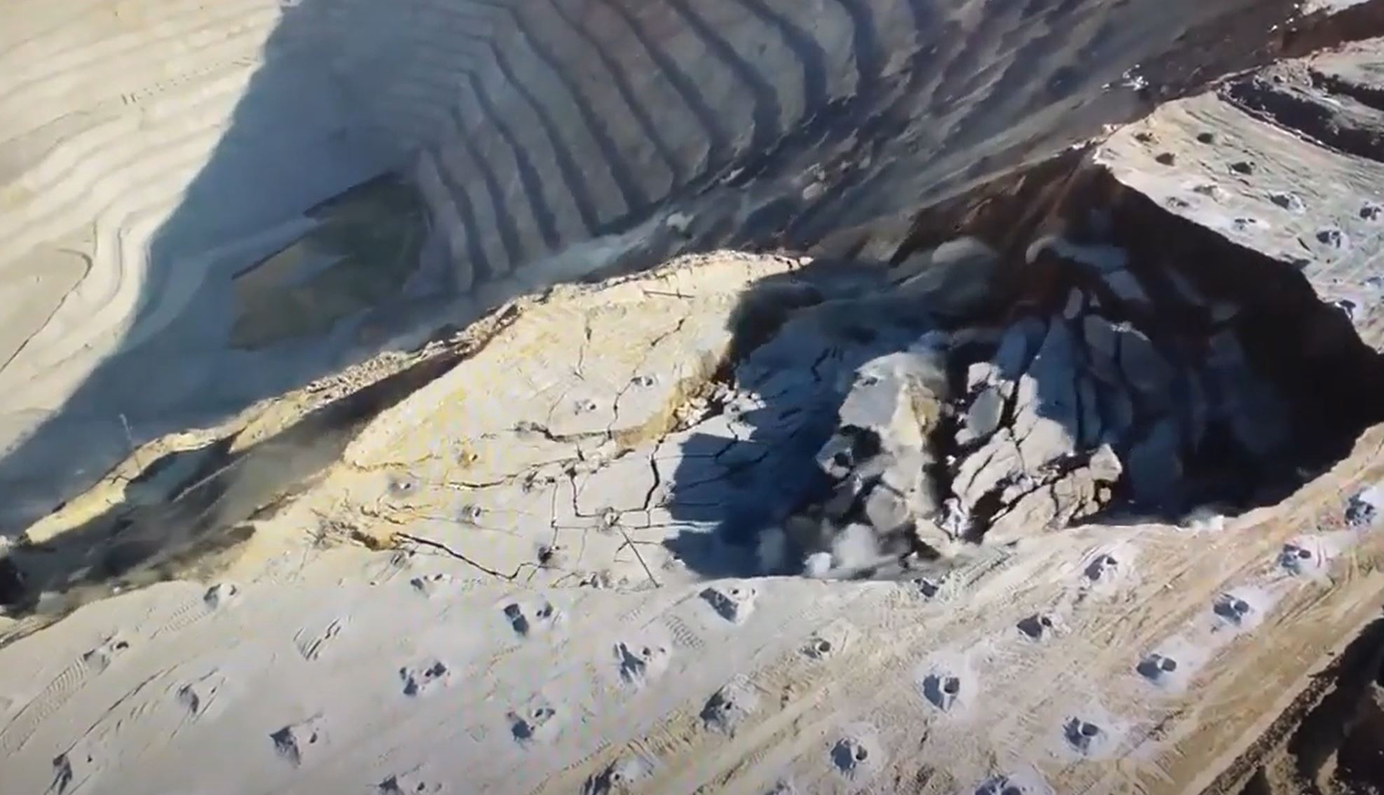
The initial failure of the 31 May 2021 landslide at Bingham Canyon in Utah. Still from a video posted to Youtube.
.
Note how the surface of the main block remains approximately horizontal. At the rear a smaller block starts to fail slightly later than the main block. This slice rapidly fragments as it loses support from the main block. Thereafter the entire landslide slowly fragments and, eventually, becomes engulfed in dust. Small secondary failures develop across the scar of the landslide.
This is one of the most impressive failures caught on video to date. That the drone team were in place suggests that the mine had correctly predicted not just the location of the landslide but also its timing. The result is an excellent case study.
Incidentally, there is a book about the 2013 landslide, entitled Rise to the Occasion by Brad Ross. It is, unfortunately, very expensive. Has anyone here read it? Is it worth a read?
 Dave Petley is the Vice-Chancellor of the University of Hull in the United Kingdom. His blog provides commentary and analysis of landslide events occurring worldwide, including the landslides themselves, latest research, and conferences and meetings.
Recent Comments