4 June 2021
The 31 May 2021 landslide at the Bingham Canyon mine
Posted by Dave Petley
The 31 May 2021 landslide at the Bingham Canyon mine
At 9 am local time on 31 May 2021 a large landslide occurred at the Rio Tinto Kennecott mine at Bingham Canyon in Utah, USA. This site is famous for one of the largest mining induced landslides ever recorded, and indeed one of the largest recent landslides in North America, in April 2013. Fortunately this landslide is on a far smaller scale.
Once again, geotechnical monitoring at the site identified the instability prior to the failure, allowing the operators to ensure that no-one was at risk.
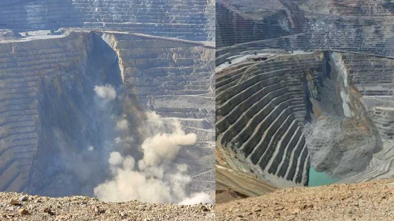
Fox 13 has posted a pair of images of the landslide:-

The 31 May 2021 landslide at the Rio Tinto Kennecott mine at Bingham Canyon. Images posted by Fox 13.
.
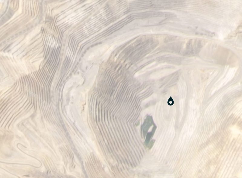
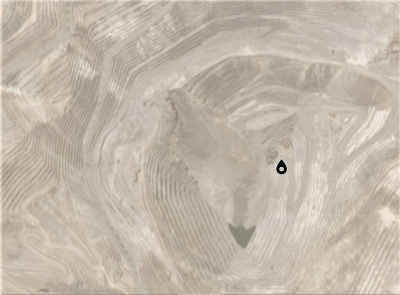
I also managed to download a pair of Planet Labs images of the site, before and after the failure – these should be visible used the slider below:


.
The image on the left was collected on 28 May 2021 and the one on the right on 31 May 2021. South is towards the top of the images.
The images suggest that the main part of the landslide, on the right side in the slide in the pictures, was a wedge failure that appears to be quite deep-seated. There is a smaller wedge on the left side too.
In its statement to the NASDAQ, the operator of the Bingham Canyon mine has confirmed that operations continue to be unaffected by the landslide.
The mining industry is the most advanced industry in terms of geotechnical monitoring of slope deformation and failure prediction. Once again this event appears to have been a successful application of those technologies.
.
Reference
Planet Team (2021). Planet Application Program Interface: In Space for Life on Earth. San Francisco, CA. https://www.planet.com/
.


 Dave Petley is the Vice-Chancellor of the University of Hull in the United Kingdom. His blog provides commentary and analysis of landslide events occurring worldwide, including the landslides themselves, latest research, and conferences and meetings.
It is a pity that the mining industry is not quite so successful in predicting tailings dam failures.
I’m really surprised they had another failure. I read the book about the 2013 failure and it seemed like they learned a lot from the Manefay failure. Given that this one was a wedge failure, would that mean they ignored signs it was going to occur?
Indeed, a well-managed event by all looks. Since 2006 GB Radar have been key tools in seeing best practices in mining slope management and operational support. Offering regular intelligence updates for decision-making wherever used. Unfortunately, not all mines have subscribed to the notion of real effective ROI and asset assurance that these tools help provide. Today too, satellite RaDAR processed InSAR data is also helpful — having the opportunity of capturing potential slow-moving precursors to the larger events — best managed by tactical slope radar positioning and deployments.
Satellite InSAR data complements the whole operation and supports the positioning of the tactical monitoring tools most efficiently. This one-four “punch” in supporting operations, safety, production, and planning creates dynamic ROI on these tools and processes. All mine site monitoring with satellite InSAR costs in the area of 14,000-120,000 USD for all site Standard – High-resolution acquisition and data packages — super affordable from firms like SkyGeo. Ground-based radar costs are in the 300,000-550,000 range — together year on costs over a 5 year period including annual support and access costs is only in the range of $2 an hour based on costs of 550000 (radar) x 5 years support (300,000) = $850,000 / (24h x 360 = 8,640H)5 | $850,000/34,560 (5yH) = $24.60 an hour — very reasonable operations assurance.
Satellite Minesite data costs are even more affordable (Dual Orbit High Res TerraSAR-X projects are about $112,000 a year X5 = 560,000/34,640 = $16.17 an hour/5Y ….. Every mining operation should be deploying a combination of satellite and Groundbased radar and terrestrial instruments — offering a real 100% operating possibility and amazing value.
It appears they were unloading the slope prior to this failure. The buttress left at the toe doesn’t appear to have arrested this instability; may be they expected more. A serious issue if they are not identifying the issue years beforehand
Thank you for sharing
Really interesting as the before and after photos look like it was moving on the 28th. Cheers –
It would appear that the mine was working on a pushback – hence the flat area to the left at the top of the failure. In essence, the failed rock would have had to be mined anyway and so the failure is of no real consequence to the actual mining operation. This is effectively confirmed by the statement from Rio Tinto that the failure will not affect mining operations.
We have to learn everyday
Some incredible drone footage of this slide has emerged… https://www.facebook.com/MiningMishaps/videos/5689491681124703/
As others suggested, it does indeed look like they already had it prepped to blast it back more when it failed.