
27 July 2021
The disastrous Taliye village landslide in Maharashtra, India
The disastrous Taliye village landslide in Maharashtra, India
In amongst the other news associated with the current range of extreme weather events, a disastrous landslide at the village of Taliye in Raigad, Maharashtra in India on 22 July 2021 barely got a mention. This is deeply unfortunate as this landslide, one of several that occurred in India last week, was catastrophic. The search operations in the aftermath of the landslide were stopped yesterday leaving a death toll of 84 people, only 53 of whom have been recovered, with a further five injured. Mid-day has a good report about the event, including this image of the aftermath:-
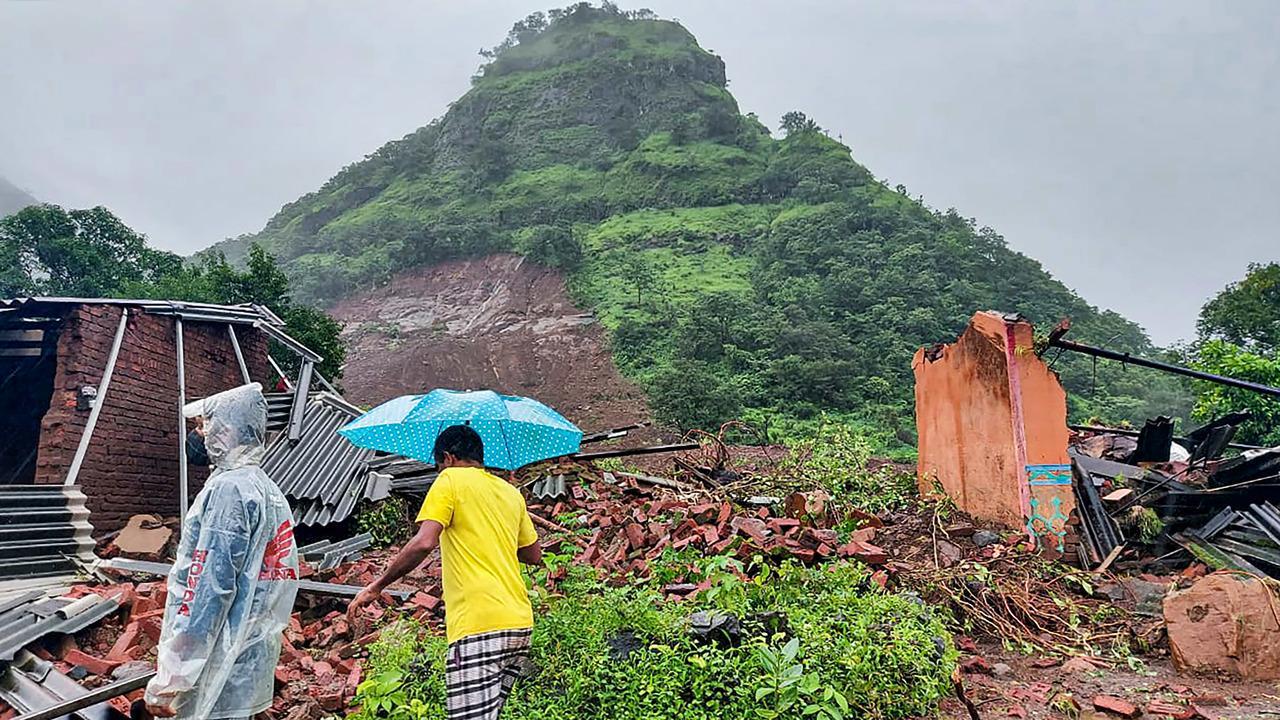
The aftermath of the landslide at Taliye in India. Image from Pic/PTI via Mid-day.
.
The location of this landslide appears to be 18.110, 73.584, although this needs confirmation. This is the location on Google Earth – it looks to be correct:-
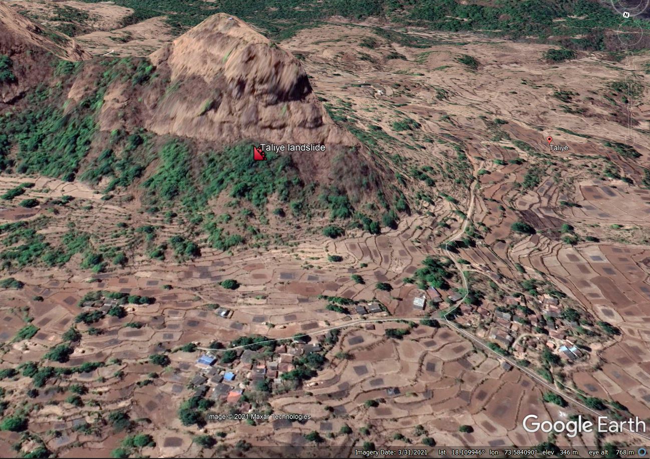
Google Earth image of the likely location of the Taliye landslide in India.
.
I believe that the geology here is likely to be the multiple layers of the Deccan Volcanic Province, meaning that the bedrock is basalt, with a high level of erosion. The landslide itself is mostly planar in nature – the Google Earth image suggests to me that this is likely to have occurred in a deposit of weathered basalt and colluvium, with the trigger being unusually heavy rainfall.
Interestingly Ajit Pawar, the Deputy Chief Minister of Maharashtra, is quoted as saying that the Taliye had not been identified as being landslide prone. This may reflect a longer than anticipated runout distance for the landslide perhaps, although we will need to wait for good satellite imagery (which is difficult to acquire in the monsoon) to be sure.
The Taliye village landslide was the largest event in the Raigad area of Maharastra last week, In total 124 people were left dead or missing, the majority of whom lost their lives in landslides.
26 July 2021
The rockslide at Batseri in India
The rockslide at Batseri in India
It has been a busy weekend for landslide stories to the degree that it’s been difficult to know where to start this morning. However, I have decided it is worth writing about the rockslide at Batseri in the Kinnaur district of Himachal Prrdesh in northern India, the videos of which circulated yesterday.
There are several videos of this event, taken from different perspectives. I think it is worth starting with this one as it shows, right at the start, the source of the rockslide:-
.
Nine seconds into the video it also shows traffic passing along the road that traverses the slope, of which more later.
The second and third videos are both in the clip that you should be able to view below:
.
These show the dramatic movement of the boulders down the partially forested slope.
And then there is the viral video (which is also in the compilation above), which is best shown in this version:-
.
The rockslide appears to have started as a result of a collapse on a very steep, rocky outcrop above the bridge at Batseri. The image below shows the terrain using Google Earth. The rock slope has numerous rockslide scars:-
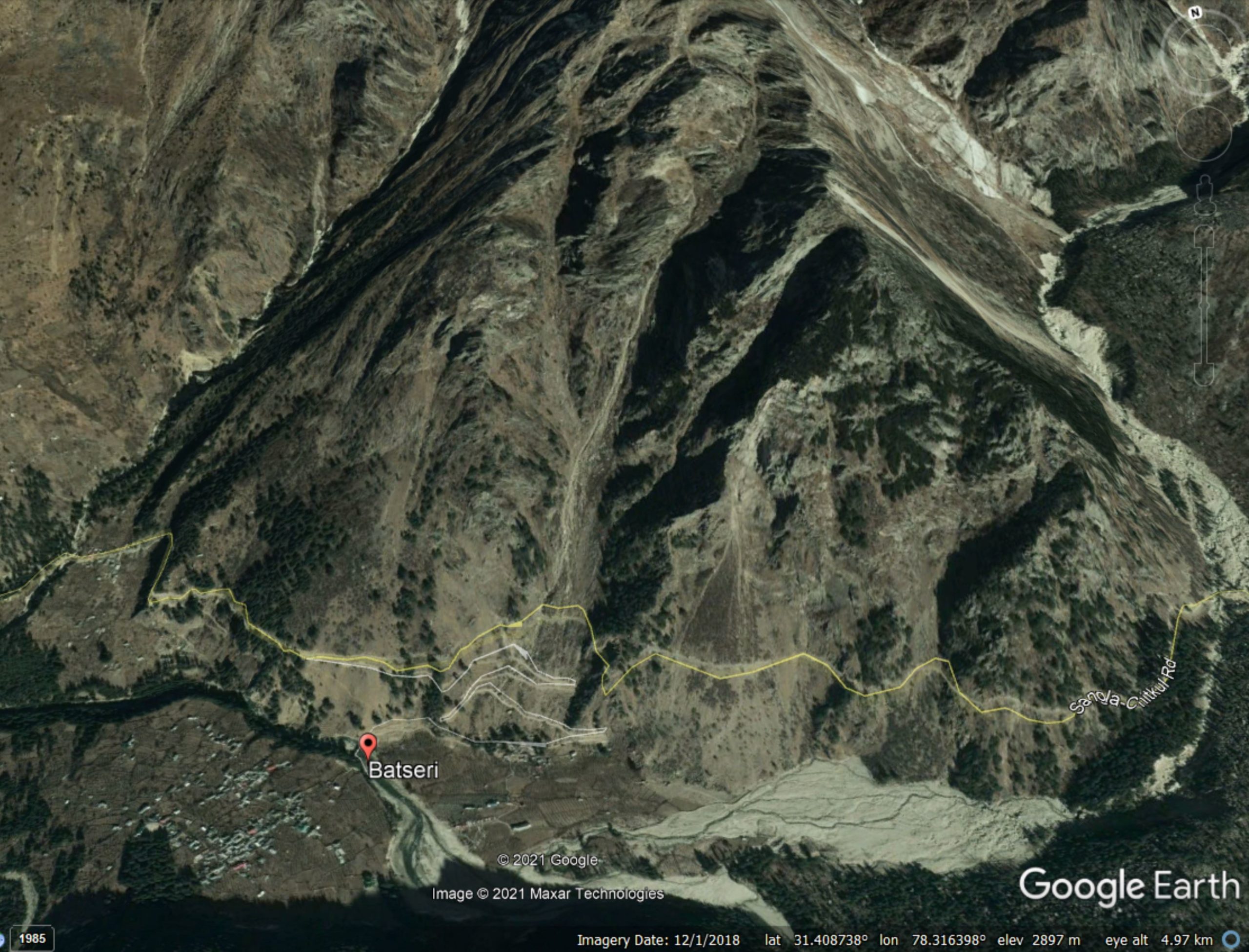
Google Earth view of the terrain at Batseri.
.
It appears that a mass collapsed, maybe about 700 m vertically above the bridge, and fragmented to generate the “evil dancing boulders”. I have noted previously that the situation in which the boulders start to rotate about a short axis and to bounce is very dangerous. This is the case for numerous boulders here, generating extremely high velocities. Before the bridge is hit one boulder (visible at about 19 seconds into the final video above) takes an enormous bounce due to the terrain:-
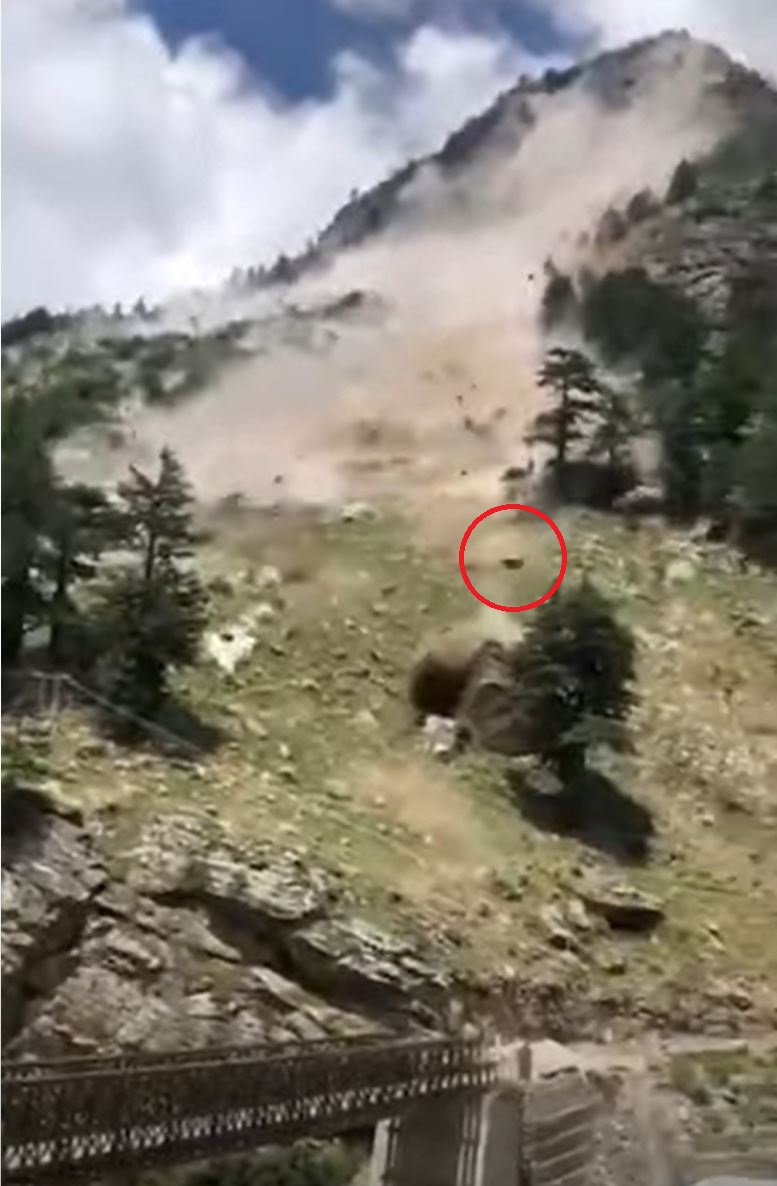
The evil dancing boulders at Batseri in India. Still from a video posted to Youtube. The boulder circled has take a huge bounce.
.
The boulder that destroys the bridge also bounced very high, meaning that it impacted the structure in close to freefall. The bridge was unable to withstand the impact.
Unfortunately there is a tragic footnote to this event. A tourist bus was traversing the road at the time of the landslide, and was hit directly by at least one boulder. Nine people were killed and three were injured. Included in those tragically killed was Dr Deepa Sharma, a well known nutritionist with a large following on Twitter. Earlier in the day she had tweeted a selfie of herself standing at the start of the militarised zone along the border with Tibet.
This stands testament to the tragedy of the event.
.
Acknowledgement
Many thanks to the various people who brought this to my attention. It is much appreciated.
23 July 2021
Benbrack: another peat landslide in Ireland
Benbrack: another peat landslide in Ireland
Over the last few years I have blogged about peat landslides in Ireland on a number of occasions. Peat landslides are particularly interesting as they tend to have a long run out and they are extremely environmentally destructive, both in the source area (where the peat can take decades or more to regenerate) and downstream, where the peat can be a terrible pollutant. And of course peat is a key (and often degrading) carbon store; losing more is bad.
The newspaper The Anglo-Celt has a story about yet another peat landslide, this time at Benbrack in West Cavan, Republic of Ireland. The location is about 54.152, -7.852. This is the topography from Google Earth:-
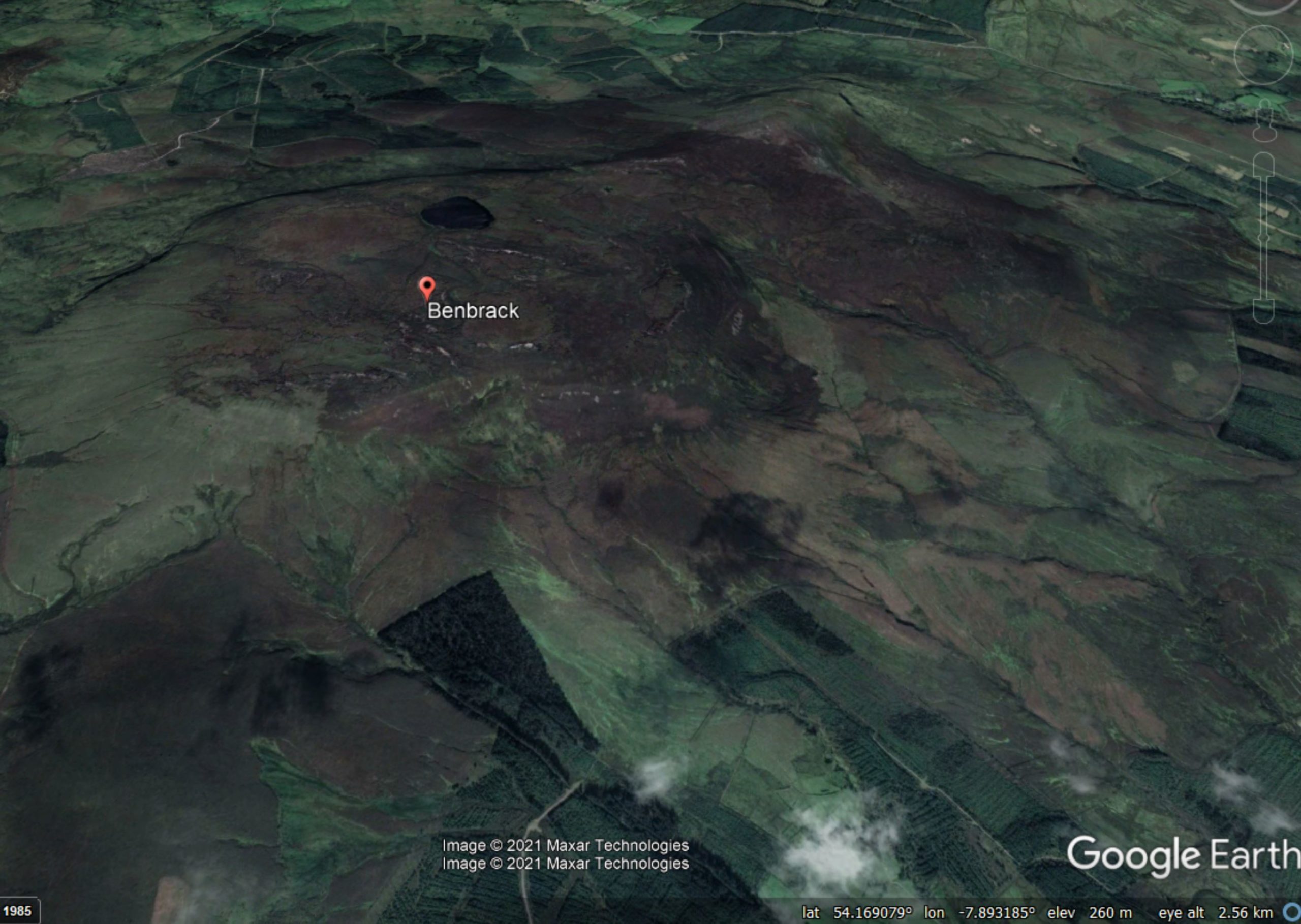
Google Earth image of the topography of Benbrack in Ireland, the site of a new peat landslide.
.
The landslide apparently occurred on 4 July 2021 during heavy rainfall. The landslide was photographed by a trekking enthusiast called Kevin Dockery:-
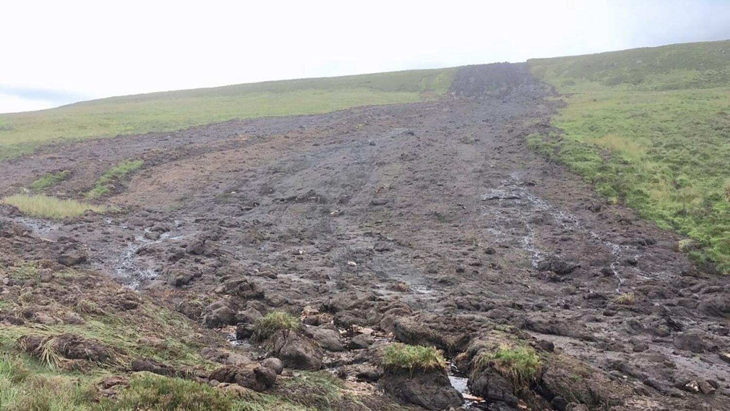
The peat landslide at Benbrack in Ireland. Image by Kevin Dockery via The Anglo-Celt.
.
The landslide is also visible on the Planet Labs imagery of the area:-
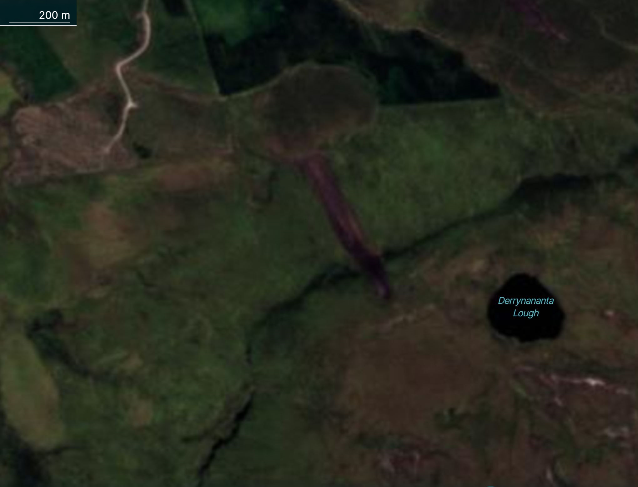
Satellite image of the peat landslide at Benbrack in Ireland. Image copyright Planet Labs, used with permission, captured on 17 July 2021. Note the scale bar. The crown of the landslide is towards the south – it moved towards the northwest.
.
Based on this image the landslide is about 600 m long. The newspaper article includes a description of the landslide:
…[T]he landslide started on the Benbrack summit plateau at a height of 470 metres above sea level, about 400m south west of Derrynananta.
“About six feet [2 m] deep of peat slipped away down the mountainside,” explained Kevin of the largest of three landslides in the area – two in Benbrack a smaller one on Cuilcagh.
“It was as if a big Hi-Mac scooped away all the peat down to the level where there were gravel and stones.
“There were massive chunks of peat gouged up – they wouldn’t fit into a car trailer they were that big. It just cascaded down the mountainside, it was extraordinary.”
This landslide does not appear to be associated with either forestry or wind farm development, as far as I can see.
.
Reference
Planet Team (2021). Planet Application Program Interface: In Space for Life on Earth. San Francisco, CA. https://www.planet.com/
21 July 2021
The extraordinary, almost unbelievable, rainfall in Henan Province yesterday
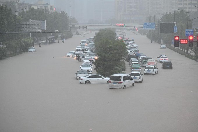
The floods in Zhengzhou in Henan, China on 21 July 2021. Image via the Hong Kong Standard.
The extraordinary, almost unbelievable, rainfall in Henan Province yesterday
There are widespread reports today of the terrible floods that affected Henan Province in China yesterday, triggering floods and landslides. There are some dreadful videos and images of the result of this rainfall, some of which are deeply harrowing, focusing mainly on the city of Zhengzhou. Xinhua is reporting that 25 people have been killed, but rescue operations continue and more heavy rainfall is forecast.
What has not been widely reported is the extraordinary nature of this rainfall event. The long term average annual rainfall in Zhengzhou is 640.8 mm. These are the stats for the current rainfall as at the end of the day yesterday:
- Max. 24 hour rainfall: 552.5 mm (from 20:00 on 19 July to 20:00 20 July);
- Max. 72 hour rainfall: 617.1 mm (from 20:00 on 17 July to 20:00 20 July);
And unbelievably:
- Max one hour rainfall: 201.9 mm (from 16:00 to 17:00 on 20 July).
This is extraordinary rainfall. To put this in context, there is a yellow weather warning for the UK for this coming weekend because there are fears of localised convective storms that might lead to locations receiving 100 mm of rainfall over the course of a 24 hour period.
As such, statistically, this rainfall in Henan was one in one thousand year event.
The highest one hour rainfall ever recorded is (I believe) 214.8mm in Penghu, Taiwan, but this was associated with a typhoon. To have >200 mm without the local presence of a tropical cyclone is very surprising.
The all time record one hour rainfall in China before yesterday was 168.3 mm, recorded at Maoming in Guangdong on 2 July 2002. Clearly the Henan event has soundly exceeded that value. It is worth noting that this rainfall event extended over a wide area, whereas many large one and 24 hour totals are highly concentrated. This may well also be the highest rainfall intensity ever recorded within a major city.
The cause of the heavy rainfall in Henan was a typhoon located to the east of Taiwan, with a high pressure system located to the north of Taiwan over the Sea of Japan. This fed an atmospheric river of water vapour into central China. This was intensified by another airstream from the south, pushed by a smaller tropical cyclone located off the south coast of China. The warm, moist air encountered the uplands of Henan, generating orographic rainfall in vast quantities.
This is of course only one of a series of extreme weather events in the last week, with severe flooding also being seen in western Europe, New Zealand, Oman and elsewhere.
20 July 2021
Hulunbuir: a very serious double dam failure in China on 18 July 2021
Hulunbuir: a very serious double dam failure in China on 18 July 2021
There has been surprisingly little international reporting of a very serious double earthen dam failure in the Hulunbuir area of Inner Mongolia in northern China on Sunday 18 July 2021. This looks to have been one of the most serious dam failure events in recent years, with 46 million cubic metres of water having been released, causing massive flooding. Reuters has a report of the event, but there are few other outlets providing much attention to it.
The dams in question are called Yong’an Dam and Xinfa Dam, located in Morin Dawa Daur. There is dramatic footage of the collapse of the Xinfa Dam on Youtube (apologies for the awful music):-
.
This dam is located at 48.609, 124.241. This is a Google Earth image in happier times:-
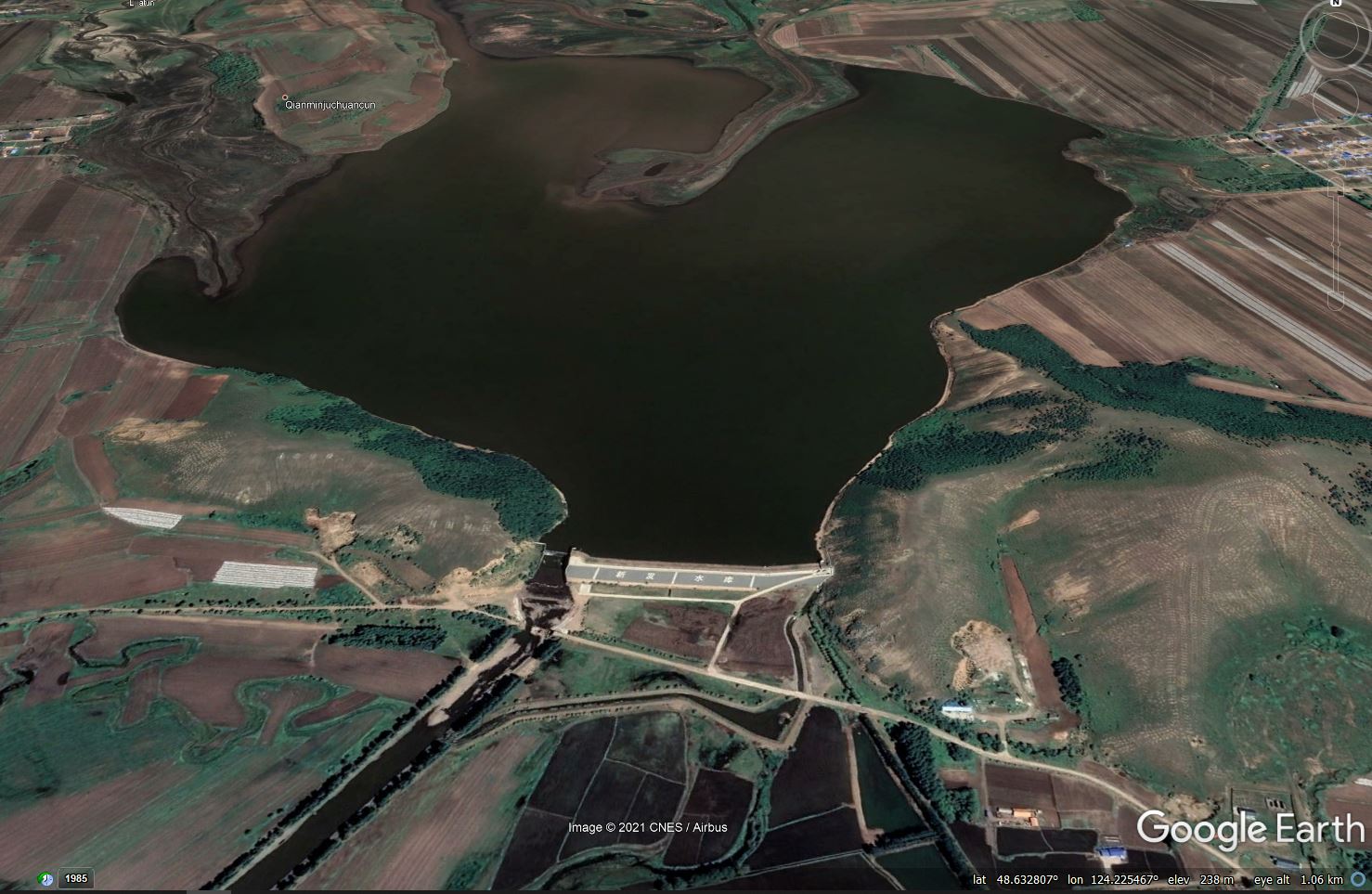
Google Earth image of the Xinfa Dam in Hulunbuir, Inner Mongolia, China, which collapsed on 18 July 2021.
.
Note that this dam has a substantial spillway structure, so overtopping is surprising. However, the video of the collapse shows that a very substantial volume of water had already overtopped the structure:-
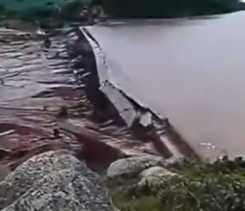
The collapse of the Xinfa Dam in China, as captured in a video posted to Youtube.
.
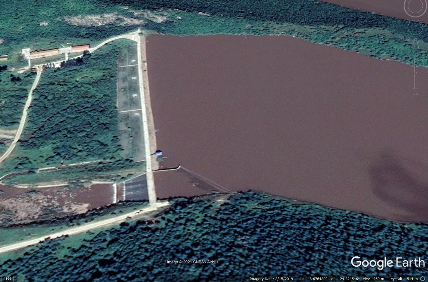
A good working hypothesis is therefore that this dam was affected by the collapse of the Yong’an Reservoir, which would have released a catastrophic volume of water. About 10 km upstream of the Xinfa Dam there is another dam, located at 48.675, 124.327. The Google Earth image below shows the comparative position of these two structures. Interestingly the adjacent town is called Yongfu:-
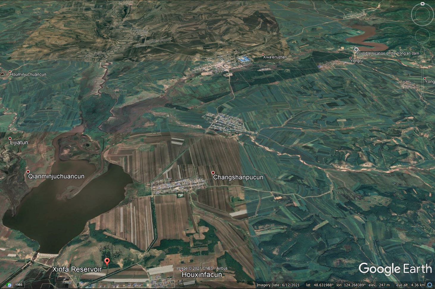
Google Earth image of the Xinfa Dam and the possible Yong-an Dam in Hulunbuir, Inner Mongolia, China, which collapsed on 18 July 2021.
.
One of the videos of the dam collapses, posted to twitter, appears to show the failure of a structure that is definitely not the Xinfa Dam:-
https://twitter.com/tw_tomy_/status/1416949532810637314
.
This is a still from this video:-
A still from a video posted to Twitter showing the collapse of the Yong’an dam in Hulunbuir, China on 18 July 2021.
.
I’m reasonable confident that this is the dam located upstream of the Xinfa Dam – the configuration looks to be identical. Edit: indeed this is now the confirmed location of the Yong’an Dam – see comments below:-
Google Earth image showing detail of the possible Yong’an Dam in Hulunbuir, China.
.
Thus, my hypothesis (untested at the moment) is that the Yong’an Dam failed due to the intense rainfall, which released a huge wave of water that overtopped and failed the Xinfa Dam, releasing a far greater volume to inundate the surrounding area.
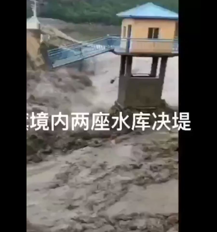
There are images and videos online showing very extensive and damaging flooding from this event, such as this:-
Flooding from the dam collapses in Hulunbuir in China on 18 July 2021. Still from a video posted to Youtube.
.
A report on Apollo News details the damage (I have edited lightly to improve the English):
“16,660 people were affected; 325,622 mu [21,775 hectares] of farmland was flooded; 22 bridges, 124 culverts, and 15.6 kilometres of highway were destroyed….Casualties are unknown.”
Given the sale of the disaster it would be surprising if there were no human casualties although the Reuters report claims that there were no casualties. In the past such reports from China have not been reliable, so the jury is still out.
Large-scale dam collapses such as this are rare but very serious. Interestingly, the Reuters reports includes the following:
China has more than 98,000 reservoirs used to regulate floods, generate power and facilitate shipping. More than 80% of them are four decades old or older, and some pose a safety risk, the government has acknowledged.
Given the rate of change of intense rainfall events, this must be of great concern.
19 July 2021
Mumbai: at least 29 fatalities in monsoon landslides
Mumbai: at least 29 fatalities in monsoon landslides
As the South Asian summer monsoon continues to intensify, the city of Mumbai in India has once again been affected by serious landslides in the last 24 hours. As is often that case, the current picture is quite confused, but details of two large events are emerging. The clearest picture at the time of writing is in an article in the Hindustan Times.
First, at 1 am on 19 July 2021 a retaining wall collapsed in New Bharat Nagar in the Chembur suburb of Mumbai, burying about five houses. In total it is believed that 19 people were killed, of whom at least four were children. At least five more people were injured.
A few hours later, at about 3 am, a further landslide occurred at Surya Nagar in the suburb of Vikhroli, burying at least seven houses. Reports indicated that ten people were killed, of whom three were children. The image below shows the aftermath of this landslide:-
The aftermath of the landslide at Surya Nagar in Vikhroli, Mumbai on 19 July 2021, which killed ten people. Image from The Indian Express.
.
Note that these landslides occurred in densely populated suburbs with informal houses constructed with a very high density. The vulnerability of such areas to slope failures is high.
News reports suggest that this was the second of two large rainfall events this week. On Friday 253 mm of rain fell, followed 235 mm of rainfall in four hours on Sunday. Reports also suggest that there had not been a warning for a heavy rainfall event on Sunday.
The Deccan Herald has a good article about the landslide problem in Mumbai, which notes that at least 290 people have been killed by slope failures since 1992. Many inhabited locations are prone to landslides, and action has been urged to relocate the most vulnerable and to engineer solutions in other spots. However, as usual I note that whilst relocation is often desirable and has been successful elsewhere, poorly planned displacement of people can make them vulnerable to a range of other (usually social) hazards, negating the benefits.
16 July 2021
Inden: a river changing course, eroding an old channel and flooding an open cast mine
Inden: a river rediscovering a previous course and flooding an open cast coal mine
The floods in Germany, Belgium and Netherlands this week have been truly catastrophic. The same storm system also caused flash flooding in London. It is likely that the this event will have triggered landslides, but we will need to wait to get more information when the priority is rescue and recovery. There are suggestions that an event has killed several people near to Cologne, but we await further information.
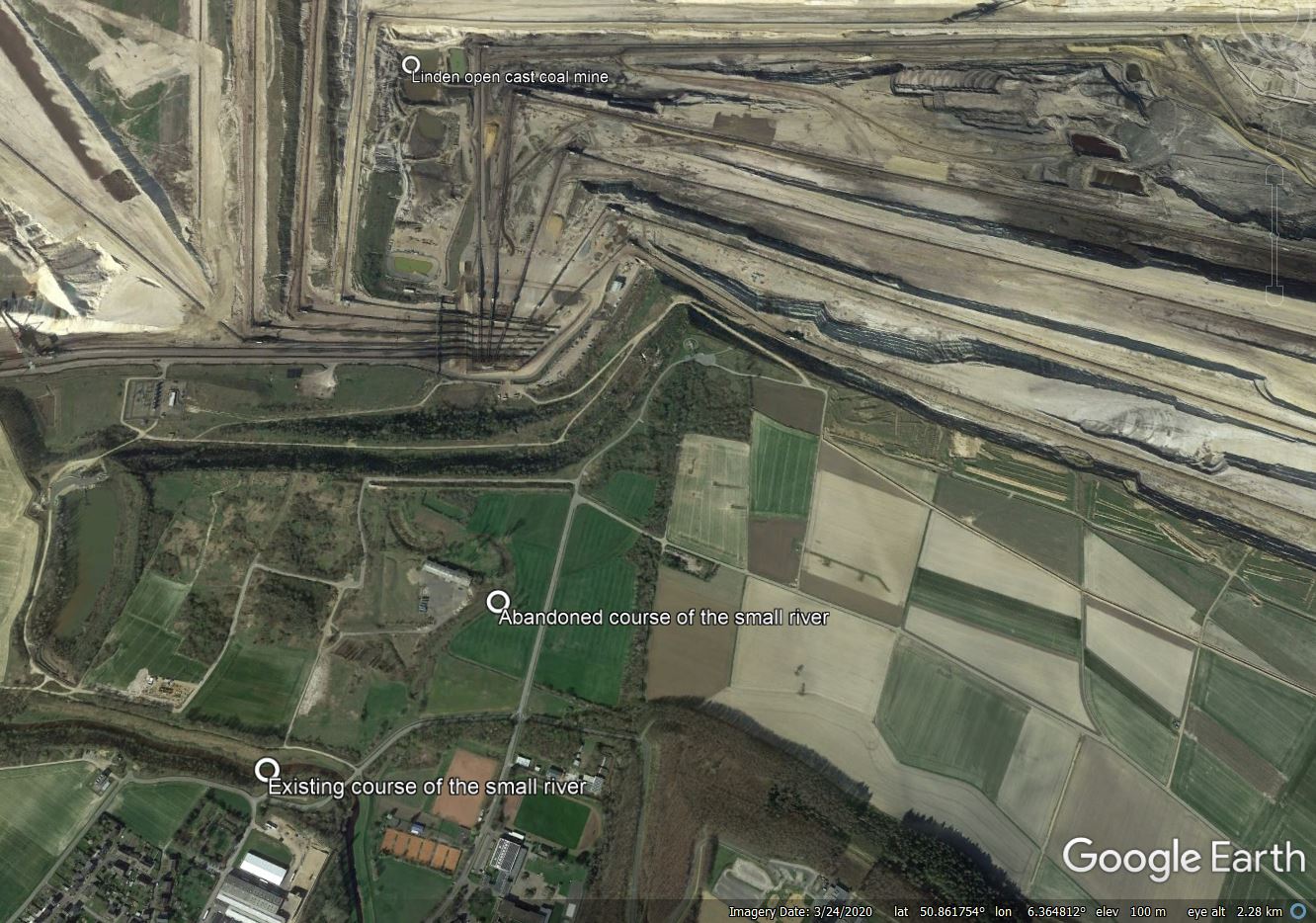
In the meantime, my attention has been drawn to a very interesting event at Inden in Germany, the site of a very large open cast coal mine. Here, the extreme rainfall has caused a small river to change course, partially flooding the mine. It is worth taking a moment to review the events. The Google Earth Image below shows the site – I have annotated the key features:-
The setting of the floods at Inden in Germany on 14 July 2021. Image from Google Earth.
.
The pertinent features here are the small river flowing towards the north from the bottom of the image, and then swinging around to flow twowards the west (presumably rerouted around the mine), An abandoned river channel is clear, with a large bend around the building:-
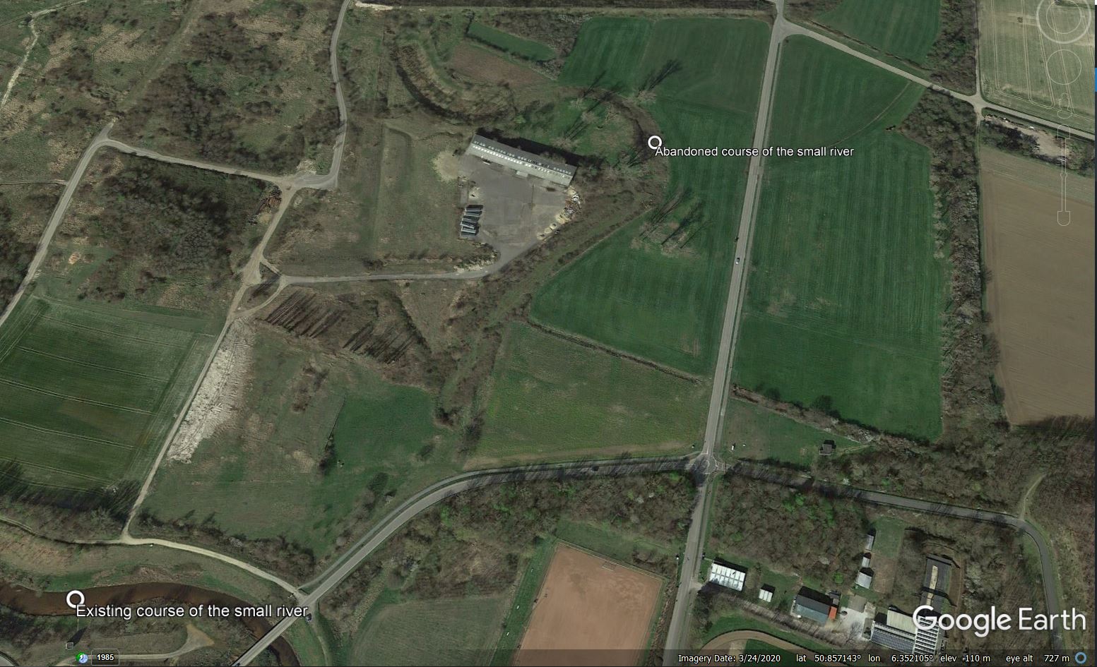
The abandoned channel at Inden in Germany. Image from Google Earth.
.
In the rainstorms of 14 July 2021 the small river has burst its banks and reoccupied its former course. The effects are dramatic. This video captures the huge erosion that has occurred as the flood has occupied, and down-cut, its channel:
https://twitter.com/cheetah_spotty/status/1415693905916538881
.
The water has flowed into a very large open cast coal mine, causing serious damage. There are videos on Twitter showing thgis in action:
Bursted in inden, the river 'inde' floating into coal mine.. Which is filled in 24 hours pic.twitter.com/IYH4gAFxjb
— Jana Schiffer (@SchifferJana) July 15, 2021
.
#tagebau #inden von #rwe geflutet #KohleArmin #LaschetLuegt #KlimakriseISTjetzt #LaschetVerhindern #LaschetWelle pic.twitter.com/61Su9wcyLs
— #Hambi bleibt (@DanniPilger) July 15, 2021
.
And this image shows the aftermath:-
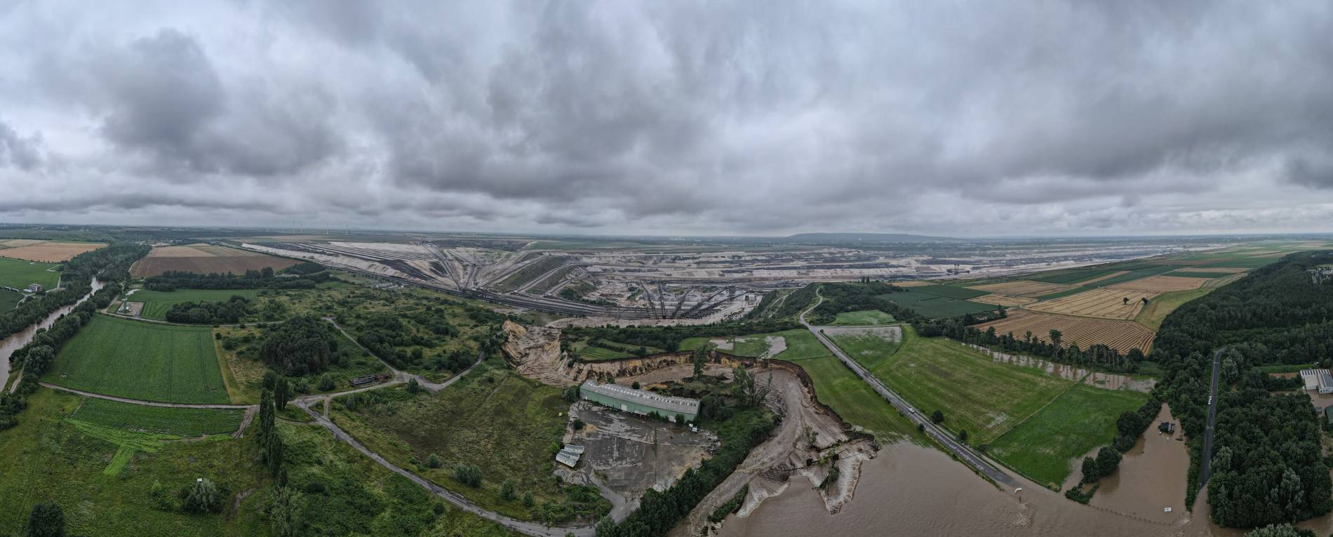
The aftermath of the flooding event at Inden in Germany. Image by Guido Jansen via Aachener Zeitung.
.
For a river to change channel during a flood is not unusual. In this case, the base level of the channel has been reset by the mining operations. The erodible materials then allowed the river to down-cut, creating the new, deeply incised watercourse.
The European floods are another example of global heating playing out in real time with tangible impacts. The last few years have demonstrated that regional effects are already intense, generating extreme temperatures and extreme rainfall, with a lot more heating baked into the system. I can only add my agreement to that of others, as expressed in a BBC article today – we don’t know exactly how much trouble we are in, but we do know that it’s very bad indeed.
13 July 2021
Diablerets: a very interesting video of a rock topple from the Swiss Alps
Diablerets: a very interesting video of a rock topple from the Swiss Alps
On Friday 9 July 2021 a rock topple occurred on the flanks of Le Dôme, a peak above Diablerets glacier in Switzerland. This rockfall was captured on a Go Pro camera by an anonymous skier on the glacier. The video is featured in a news report posted to the 20min.ch website. It is worth a visit – I can only post stills here:-

The rock topple above Diablerets glacier in Switzerland on 9 July 2021. Still from a video posted to the 20mins.ch news site.
.
The scale of this topple is difficult to appreciate – I suspect that it is less large than it appears. On the French version of the story on the 20mins.ch website it is reported to have been 30 metres tall but only 50 cubic metres in volume, which seems surprisingly low.
This is a classic topple, actually in the form of two pillars. Note also the rock debris that falls down the rock face as the pillars rotate away, and the way in which the blocks break up even before impact upon the glacier.
As I have noted previously, high altitude rockfalls often occur in the Spring and early Summer as a result of permafrost melting, and the role of climate change. The warm conditions at Diablarets on the day of the rock topple are clear from the video.
Interestingly, in the French version of the report, the local cantonal geologist is quite dismissive of the event (this is a machine translation):
“It’s good on the Valais side,” confirms Raphaël Mayoraz, cantonal geologist, who went up to see the situation in the afternoon. “It is a pillar about 30m high, or about 50 cubic metres, which collapsed from the small south face of Les Diablerets on a small glacier. A priori it does not represent a danger for people and infrastructures, except perhaps for mountaineers. The event is spectacular but relatively minor in terms of volume and impact. This does not give a clearly visible change in the morphology of the terrain. ”
The geologist indicates that the explanation is to be found on the side of the natural erosion of the massif, and the rains of recent days. “There is no trace of ice, which is unrelated to the melting of the permafrost. The overnight freeze / thaw hypothesis is plausible, but difficult to prove. The event is also not linked to climate change and in my opinion the retreat of the glacier has no direct impact on the instability of the cliff. ”
Bold statements indeed!
Many thanks to Martin Luethi for the heads-up on this one.
12 July 2021
The cause of the Petobo landslide from the 28 September 2019 Palu-Donggala Indonesia earthquake
The cause of the Petobo landslide from the 28 September 2019 Palu-Donggala Indonesia earthquake
Possibly the largest landslide-induced loss of life of the last few years was caused by the series of large liquefaction landslides triggered by the Mw=6.1 28 September 2019 Palu-Donggala Indonesia earthquake. I blogged about these events extensively at the time, and also noted that the GEER reconnaissance mission had provisionally suggested that the major cause might have been the presence of a series of canals high on the slopes.
A paper has recently been published in the journal Landslides (Kusumawardani et al. 2021 – you should be able to read the paper here) that examines one of the largest of these events, the landslide at Petobo in Palu. Just this landslide alone caused the destruction of about 3,300 houses and almost 2,000 people lost their lives.
The paper is a detailed description arising from a site reconnaissance. It is a very valuable catalogue of the features observed, accompanied by a high quality interpretation of them. This, for example, is an interpretation of the movement vectors of the observed features on the ground. These are remarkable given that the average slope gradient is just 2°.
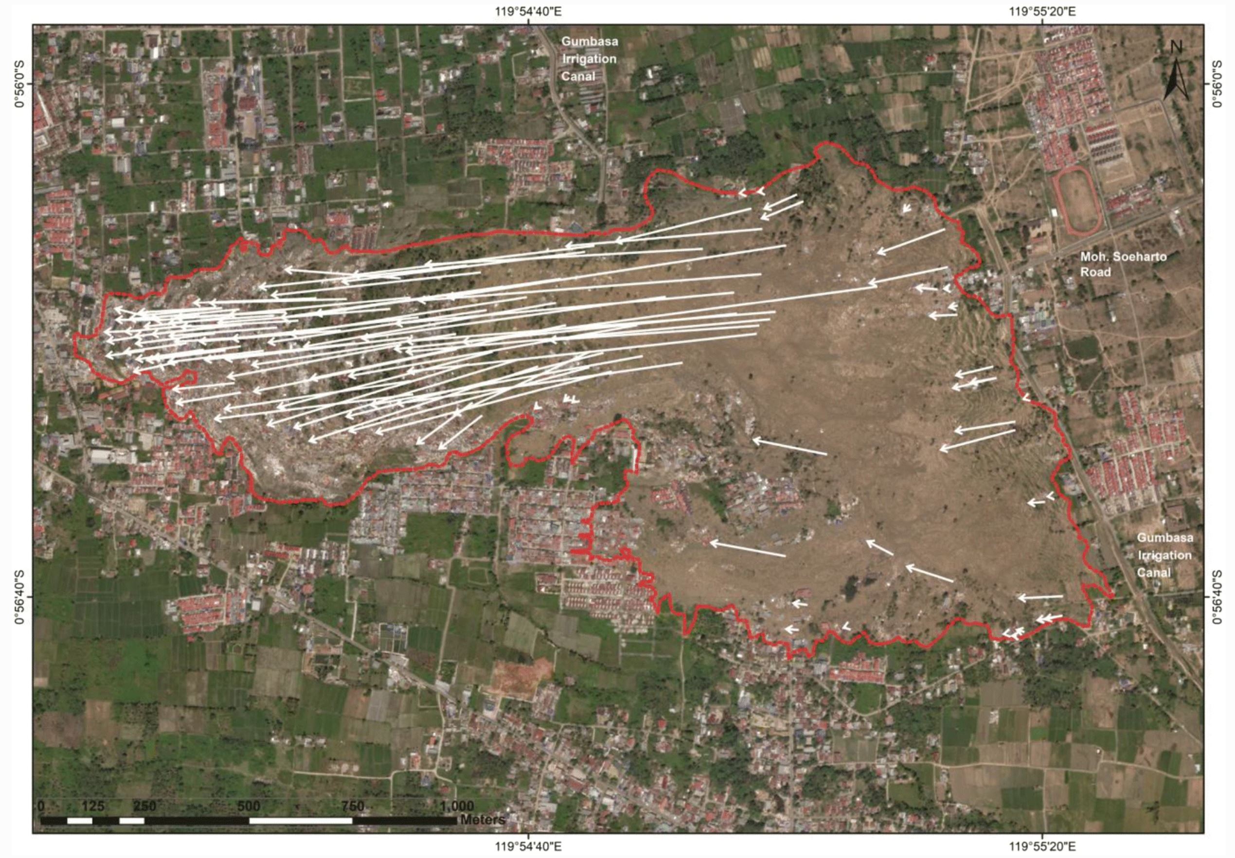
Movement vectors for the landslide at Petobo in Indonesia. Figure from Kusumawardani et al. (2021).
.
Kusumawardani et al. (2021) have revisited the issue of the cause of the Petobo landslide. They have considered carefully the role of the irrigation canal near to the crown of the landslide – note that this can be seen on the image above. The authors note that the unlined canal was constructed around 110 years ago. It had been upgraded through time but was unlined, and thus would have been charging the local groundwater levels. Prior to the earthquake the canal was full, and that it was being used to flood the local paddy fields to a depth of 30 to 50 cm.
Thus, Kusumawardani et al. (2021) have concluded that it is highly likely that the canal, and the resultant high groundwater levels and inundated paddy fields, led to a high level of susceptibility at Petobo to the effects of the earthquake.
An interesting aside is that the landslide was not rapid – the authors estimate that the rate of movement was in the order of 2.5 to 5 km/h, which is no more than a rapid walking pace.
An interesting question is whether this situation occurs in other earthquake prone areas in Indonesia.
.
Reference
Kusumawardani, R., Chang, M., Upomo, T.C. et al. 2021. Understanding of Petobo liquefaction flowslide by 2018.09.28 Palu-Donggala Indonesia earthquake based on site reconnaissance. Landslides https://doi.org/10.1007/s10346-021-01700-x
9 July 2021
A very disruptive start to the summer monsoon in Nepal
A very disruptive start to the summer monsoon in Nepal
The summer monsoon is now fully underway in Nepal, bringing heavy rainfall to a large swathe of the country. The early part of the monsoon has been unusually intense, with large numbers of rainfall-related incidents, including landslides and flood. According to an article in Khabarhub today, the monsoon has cost 51 lives already, including 10 children. A further 29 people are reported to be missing.
Nepal now collects and publishes good data on the incidence and costs of disasters via a DRR hub. In terms of landslides, from 1 June 2021 to 8 July 2021 a total of 135 landslide events have been recorded, leaving 27 people dead and a further 7 missing. Once again, more than half the people killed in the monsoon have died as a result of landslides. A further 41 people have been injured.
I have very quickly graphed the cumulative total number of reported landslides since 1 June 2021 (the data runs to 8 July 2021):-
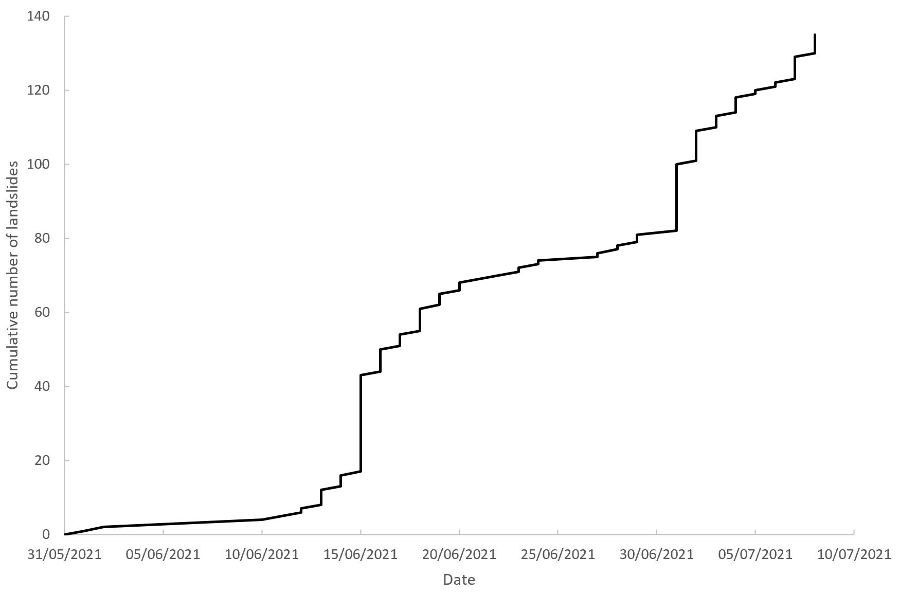
The reported number of landslides in Nepal since 1 June 2021. Data from the Nepal DRR portal.
.
As normal, landslides occur in intense period with comparative calm in between, reflecting the passage of weather systems across the country. There was an unusual early event around 15 June, and many more since the start of July.
In the last 24 hours, seven people have been killed in monsoon-related events. The Kathmandu Post reports that:
Three people were killed in a landslide at Jamir village in Naugad Rural Municipality-3 of Darchula district in Sudurpaschim Province on Wednesday night…In Tanahun of Gandaki Province, two persons were killed in a landslide at Dadhiban of Rishing Rural Municipality on Thursday morning, police said…In Palpa, two persons died in separate incidents at Tinau Rural Municipality-5 on Thursday. Police identified the deceased as Bir Bahadur Gurung, 45, of Hiudekhola and a four-year-old boy of Gittikhani. Gurung was buried when a landslide struck his house at around 3am while the child was swept away by a torrent.
Unfortunately, there is likely to be further events in the coming days. This is the NASA 3 hour nowcast for landslides in Nepal:

NASA landslide nowcast for 08:00 UT on 9 July 2021. Red is a high likelihood, yellow is moderate.
.
Interestingly, poor road building is increasingly identified as being a major factor in the high incidence of landslides in Nepal. For example, The Himalayan Times yesterday had a report on landslide impacts in Himali Rural Municipality in Bajura:-
According to Himali Rural Municipality Chairperson Govind Bahadur Malla, 40 families in Faiti village in Ward 4 and 97 families in Kyudi of Ward 5 of Himali Rural Municipality were displaced after the ground in their villages caved in. “The ground in the villages developed cracks and caved in, apparently due to the road dug from below the villages.
While some houses have already crumbled, the others which are still standing are at risk,” said Area Police Office Kolti in-charge Devendra Joshi, who returned after conducting field monitoring of the villages.
The cave-in was caused by the under-construction Rugin-Bichhyan access road built with the provincial government’s investment.
This is a pattern the occurs repeatedly.
 Dave Petley is the Vice-Chancellor of the University of Hull in the United Kingdom. His blog provides commentary and analysis of landslide events occurring worldwide, including the landslides themselves, latest research, and conferences and meetings.
Recent Comments