2 August 2021
Melamchi – satellite images and helicopter videos start to explain the catastrophic floods in Nepal
Posted by Dave Petley
Melamchi – satellite images and helicopter videos start to explain the catastrophic floods in Nepal
On 14 June 2021 a huge debris flow and flood destroyed Melamchi in Nepal. The event was triggered by heavy rainfall, and as I noted a few days after the event, there is a very large landslide upstream of the village that might explain the surge that came down the valley. However, the event has been slightly mysterious, partly because satellite images have not been available of most of the area upstream of Melamchi. It is now clear that the event was more complex, and more concerning, than was initially obvious.
Satellite imagery is slowly becoming available – this is slow as the area is still covered in monsoon cloud most of the time. To understand this event we have to go right up to the headwater area in the high mountains. This is the site:-
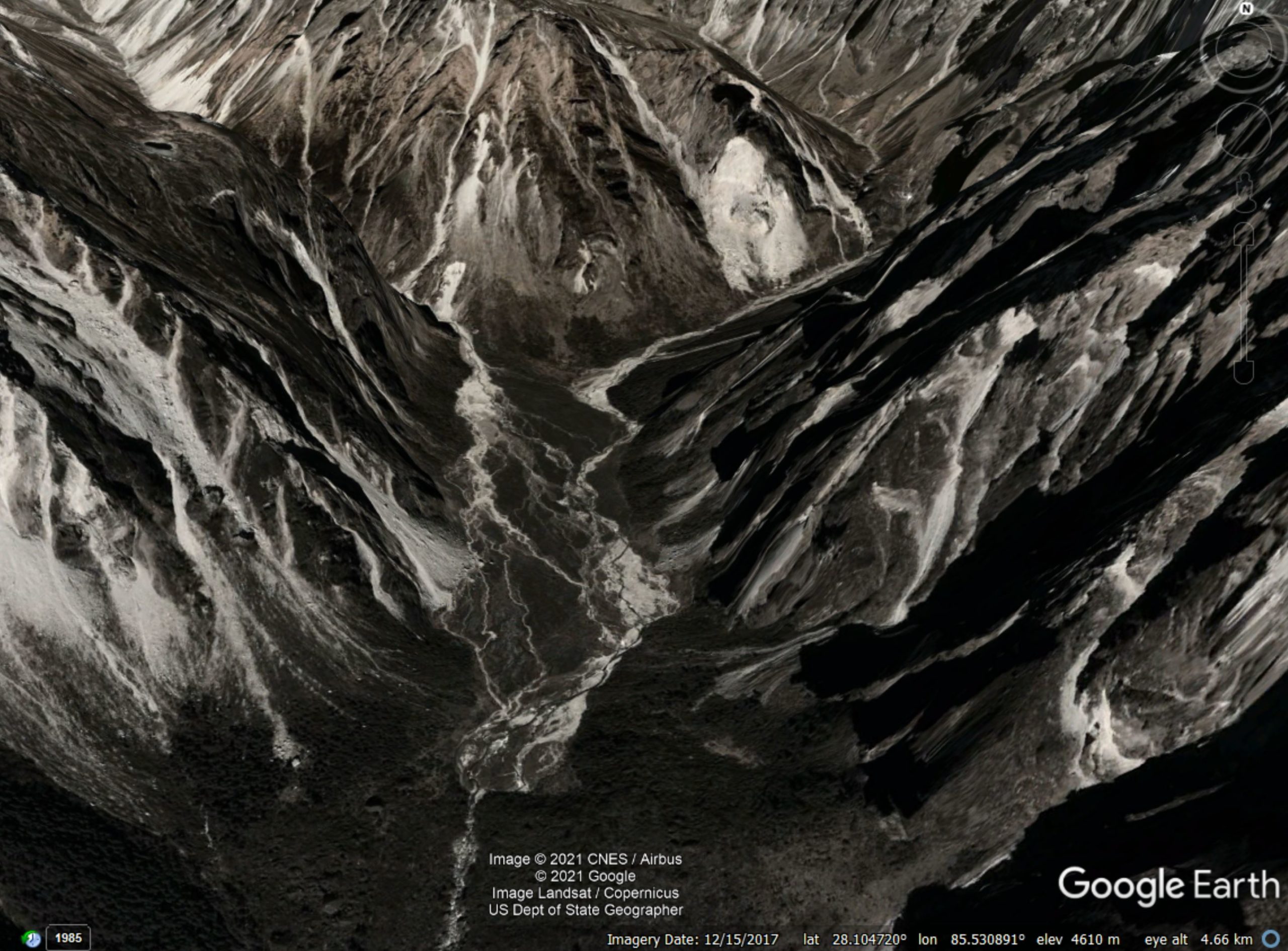
Google Earth image of the headwaters above Melamchi.
.
This is a very steep, very rugged terrain. Note in the centre of the image the large volume of sediment, partially vegetated, in the valley floor, trapped against some sort of barrier (very possibly an old landslide deposit).
Planet Labs captured an image of the same area on 29 July 2021. This is not the best image, but the change is startling:
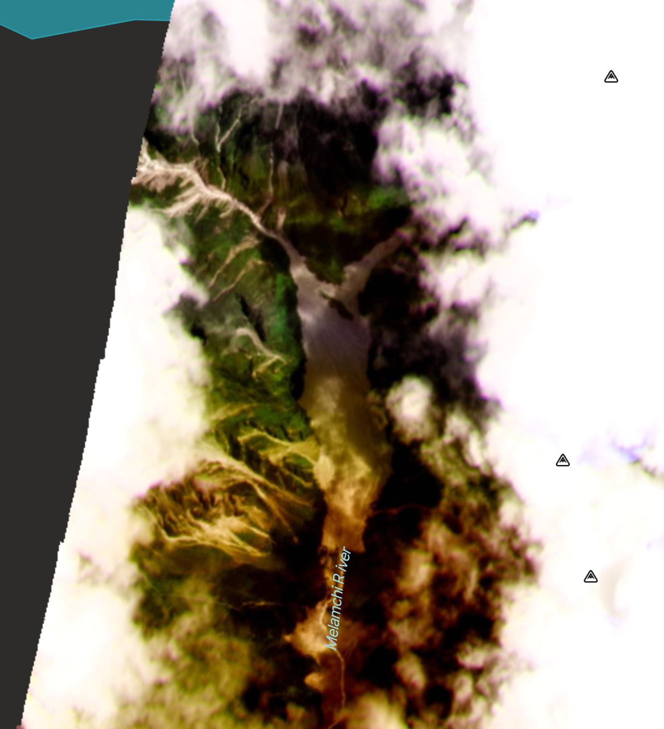
Satellite image of the headwaters area above Melamchi, captured on 29 July 2021. Image copyright Planet Labs, used with permission
.
Upstream of this area there are some landslides, most notably from the valley to the northwest. But there appears to be huge mobilisation of the sediment trapped behind the barrier.
Further insight comes from a pair of Tweets yesterday by Shiva Dahal (@dahalshivaji), which included both photographs and a startling video of the site:-
https://twitter.com/dahalshivaji/status/1421754169904357376
.
The lower left image shows this area of sediment, clearly dramatically mobilised by the flood. The helicopter video captures this even more clearly:-
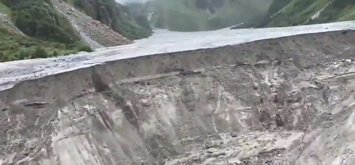
The collapsing front edge of the sediment deposit upstream of Melamchi. Still from a helicopter video posted to Twitter.
.
The view looking downstream is, if anything, even most dramatic:-
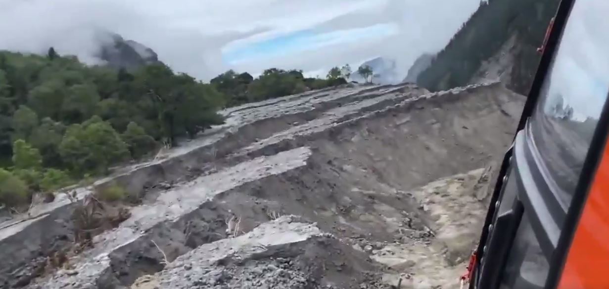
The collapsing front edge of the sediment deposit upstream of Melamchi. Still from a helicopter video posted to Twitter.
.
My interpretation is that this is effect the breach of an ancient landslide dam, which is now collapsing under successive rainstorm events. The sediment pile extends from about 2 km, and only a small proportion has mobilised to date.
The sediment pile is collapsing rapidly – the video even captures small collapses occurring – with big slumps developing, as seen in the second video. Downstream, a huge amount of erosion has developed, and the walls of the channel have collapsed extensively:
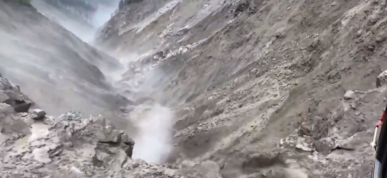
The deeply eroded channel upstream of Melamchi. Still from a helicopter video posted to Twitter.
.
Further downstream, as I noted in a previous post, there is a large landslide near to the village of Melamchigaon, but it appears that this was not the cause of the disaster:-
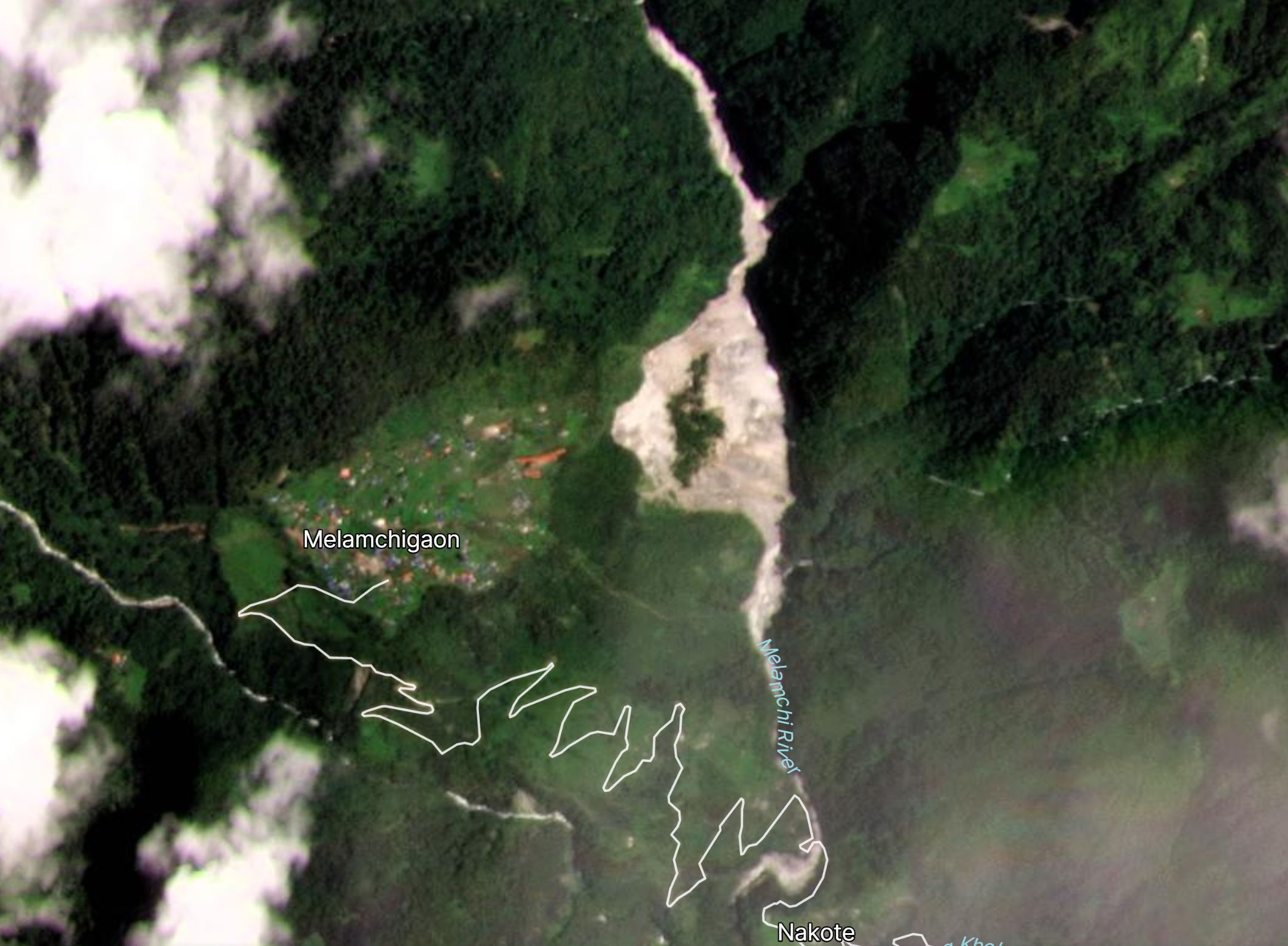
Satellite image of the landslide close to Melamchigaon. Image copyright Planet Labs, used with permission
.
These images are grim in terms of the safety of Melamchi. There appears to be a huge, unstable mass of sediment, undergoing collapse, upstream of the town. Heavy rainfall is likely to bring further major floods and debris flows, and indeed on Saturday a further dozen houses were lost to floods in the area.
My analysis is not definitive – indeed it is only provisional – a much more detailed examination of this site is needed (and is hopefully underway), led by local teams.
There is a much larger consequence of this event though. Melamchi is source of a major drinking water project for the capital city of Kathmandu – the Melamchi Drinking Water Project (MDWP). The works, which started to supply water to the city on 28 March 2021 after 23 years of construction, were substantially damaged in the June event. The excellent Himalayan Times has a good article about the impacts:
The head works of MDWP has been covered 10 metres high with flood debris according to officials. Worst of all, the flood has swept away around 10 kilometres road from Melamchi Bazaar up to the headworks, including two major concrete bridges.
The estimated costs to the project are 2 billion rupees (about £12 million), but the full extent of the damage is unclear.
However, there is a real but unquantified risk that the problems are much more serious, with continued large-scale mobilisation of sediment in future rainstorms. Once again, this needs very urgent attention.
.
Reference
Planet Team (2021). Planet Application Program Interface: In Space for Life on Earth. San Francisco, CA. https://www.planet.com/


 Dave Petley is the Vice-Chancellor of the University of Hull in the United Kingdom. His blog provides commentary and analysis of landslide events occurring worldwide, including the landslides themselves, latest research, and conferences and meetings.
In the upper reaches of the right tributary Melamchi Khola, you can see a large glacial lake (28 ° 9’4.04 “, 85 ° 29’45.24”), space image date in Google 12.15.2017. Maybe its breakthrough caused a catastrophic mudflow?
I’m with User. It appears to me that an enormous slug of water punched through that system, either by localized downburst or headwater lake blowout. That flat valley floor created by the landslide dam probably stored a large body of relatively loose sediment. A hyperconcentrated flood or debris flow would have been able to do a lot of mechanical erosion of that dam, leading to the catastrophic erosion of its outfall and mobilization of the impounded sediment we now see.
Also, as an addition to the comment above, if you look at the historic sat images on Google Earth, from at least 2017 the glacier that was in-front of that lake has been retreating…
Wow! That’s some very impressive sediment remobilisation. Looks like it will cause a cascade of geomorphic consequences for many decades? The Google Earth image dated Feb 2013 is reasonably clear – appears to show a landslide dam deposit impounding the very large volume of sediments now eroding.
I have taken a look at the glacial lake highlighted by User. On the 23 June imagery it was still intact, so was not the cause of the flood.
The erosion seems to start downstream of about 28.116, 85.533, although there is a great deal of shadow that makes interpretation difficult. The images do show a huge amount of snow and ice melt between 6 and 23 June. So my initial hypothesis would be that the source of the water was rainfall driving snowmelt, but that is just an opinion. We won’t really know until better imagery becomes available – after the monsoon I expect – and even field work.
After looking at google earth, it seems to me that the lake is on the other side of the mountain (it also could be a topographic artefact of google), so a burst won’t be able to go East. Another smaller lake is visible on the East side ( 28° 7’51.90″N, 85°30’53.87″E), but it could also be a serac fall (from hanging glaciers around), a rock avalanche going debris flow… waiting for sat or heli pictures !
ICIMOD have now published a comprehensive initial analyses of the Melamchi disaster – https://www.icimod.org/article/the-melamchi-flood-disaster/
There is a field reconnaissance on this if someone is interested. However, I haven’t read the report yet by myself.
https://www.researchgate.net/publication/353184908_Multi-perspective_field_reconnaissance_after_the_Melamchi_debris_flow_of_June_15_2021_in_Central_Nepal
The ongoing event could be a medium scale example, for this type in this region. The Planet Labs satellite image of Melamchigaon suggests that this village is located on a terrace generated by a similar event. I lack scale and depths for either location, but the image’s road (trail ?) trace suggests that the presumed alluvial infill at Melamchigaon, and thus the presumed landslide dam, were several times as deep, as in the current event.