14 July 2022
San Antonio de Prado: a high mobility landslide in Colombia
San Antonio de Prado: a high mobility landslide in Colombia
On Wednesday 13 July 2022 a major landslide occurred at San Antonio de Prado in Medellin, Colombia, killing at least two people. Videos of the event have been circulating on social media. For example, this news report on Youtube shows a slice of the rear scarp failing and then transitioning into a mobile flow, whilst from about 40 seconds it shows a different angle of the flow event:-
.
Later in the video there is drone footage of the aftermath, and some segments showing the impacts on the channels downstream.
El Colombiano has this image of the aftermath of the landslide, showing the landslide source and much of the long debris train:-
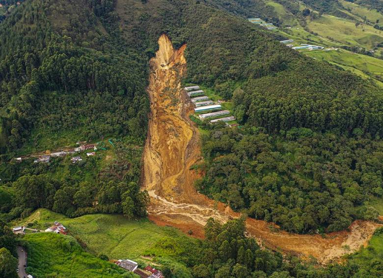
The aftermath of the 13 July 2022 landslide at San Antonio de Prado in Colombia. Photo by Manuel Saldarriaga via El Colombiano.
.
The location of the landslide is, I believe, 6.196, -75.658:-
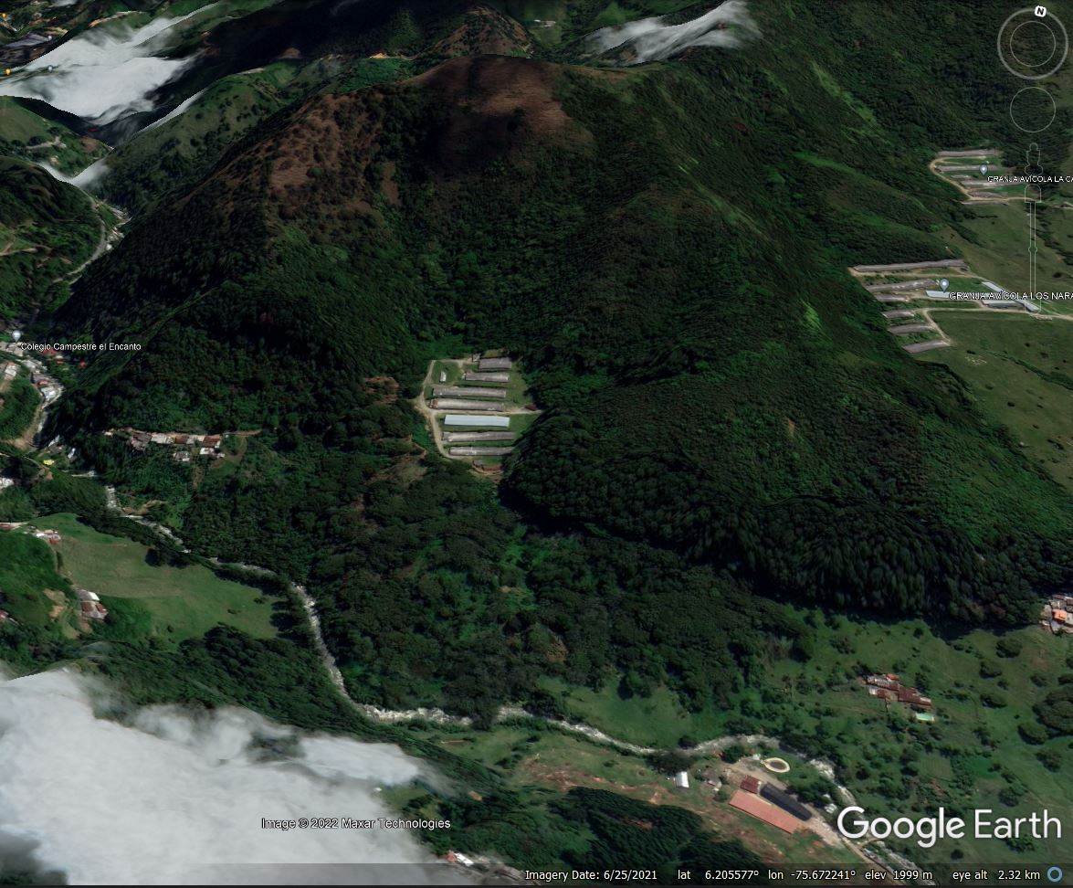
Google Earth image of the site of the of the 13 July 2022 landslide at San Antonio de Prado in Colombia.
.
It is interesting to note that the most recent Google Earth imagery, from November 2021, shows the site of the landslide to have been forested. The area around the landslide site appears to have suffered from landslides in the past, and the geological maps of the region mark much of this area as being slope deposits.
News reports indicate that the local communities had been concerned that a failure was developing on the hillside prior to the landslide. Infobae has a report (in Spanish) that highlights that a failure had developed over several months, and that Medellin Council was warned of the risks on 29 June 2022, which led to a visit by the Undersecretary for Physical Infrastructure, Adrián Alexis Correa. It appears that there are video records community leaders warning that a major landslide was possible.
But for now, there are concerns about further instability and of the implications of the damming of the channel, Quebrada Doña María. This will require attention in the coming days.
There has been heavy rainfall in Colombia in recent weeks, linked to the current La Nina conditions that are also triggering landslides in, for example, eastern Australia.
11 July 2022
Naina in Khaptad, Nepal: the terrible impacts of low quality road construction
Naina in Khaptad, Nepal: the terrible impacts of low quality road construction
The Nepali newspaper Nagarik News carried an article last week, in Nepali, about the impacts of low cost road construction on an isolated mountain community. The hamlet in question in Nainam located in the area of Chhededaha village in Khaptad. The article includes this image of the location:-
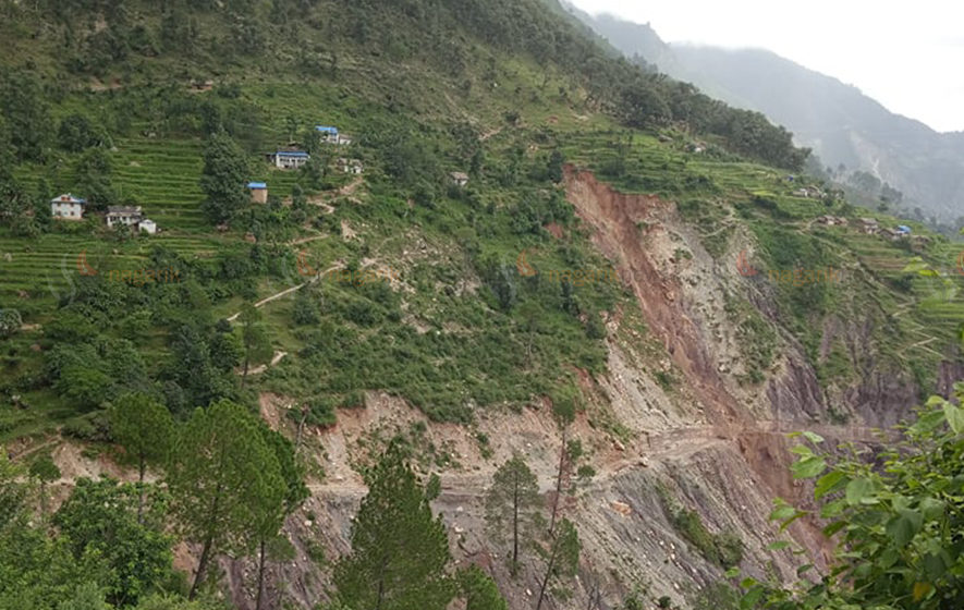
The village of Naina in Khaptad, showing the destabilising effect of low cost road construction. Image collected by a local citizen, published in Nagarik News.
.
As the image shows, a so called bulldozer road has been constructed on the slopes below the community. As is so often the case, the slope has been cut to create a road bench, with the spoil being dumped haphazardly on the downslope side. The material is likely to be colluvium sitting at its angle of repose, so steepening induces instability. The lack of drainage has of course exacerbated the problems.
In locations in which there are concentrations of water, the slope is destabilising at paces and there is active gully formation. On other sections of the road there is the potential for deeper-seated landsliding. The downslope side of the road is very badly damaged.
The article articulates the hazards faced by the community:-
Landslides have been reported day and night. A 12-meter road has been constructed below the settlement. Landslides have been raging in the village since the year the dozer built the road. There is no alternative to relocating an entire settlement. Since there is no open space nearby for comfortable accommodation, they spend the night on the roof of the local house.
In total, 25 families are being affected by these landslides. This pattern is common in Nepal, but road construction continues at a pace. Nepal is now in the middle of the summer monsoon, when these problems come home to roost.
8 July 2022
Shifting the blame for the deadly landslide at Tupul in India
Shifting the blame for the deadly landslide at Tupul in India
Recovery operations continue at the site of the 30 June 2022 landslide at Tupul in Northern India. The latest news is that 49 bodies have been recovered, whilst a further 12 people remain missing. The likelihood of recovering their remains is probably diminishing with time. In total, 29 of the victims were soldiers billeted on the landslide site, who were reportedly providing security to the project.
Inevitably, attempts are now being made to shift the blame for the disaster. The New Indian Express provides two perspectives. First, they report the words of an anonymous senior geologist from the Oil and Natural Gas Corporation:-
“We have loose soil here. The rocks are hard only in the deeper portions. So when it rains incessantly or heavily, chances are that the soil will erode,” the geologist, who has worked in the region, said requesting anonymity…”To avoid such incidents where development projects are coming up, we must ensure maximum plantations. Only the plants with roots that can reach the sub-surface should be planted in consultations with experts,” he said, adding that in Uttarakhand, which has hard rocks, the retaining walls should have steel nets to keep the earth stable.
Vegetation is of course important in landslide management, and it brings many other benefits. But there is no evidence that vegetation, or lack thereof, was the cause of the landslide at Tupul. Indeed, the deep-seated nature of the failure indicates that vegetation was probably essentially irrelevant. The clear evidence of slope cutting is likely to have been far more significant, although as I noted previously this needs to be investigated properly.
Secondly, the article quotes one or more railway officials in relation to the landslide:-
“When a hill is cut for a project, the angle and the slope need to be maintained. It was adhered to,” he said … A railway official blamed jhum cultivation for the recent incident.
“Rainwater had got accumulated at the site, rendering the soil soft. That place is not a natural basin,” he said.
Jhum cultivation is a shifting form of agriculture in which the forest is cut down and burnt, and the land is then farmed for a small number of years before being abandoned. In the traditional form the land is allowed to recover, but a shift to more intensive land use means that the time period between cycles has often been reduced. The consequences can be extremely environmentally destructive.
There is little doubt that jhum cultivation can be have adverse outcomes for the land, and there may be some evidence that it has been practised in the Tupul area. However, I will leave it to readers to consider whether this is the probable cause of a deep-seated landslide at this site:-
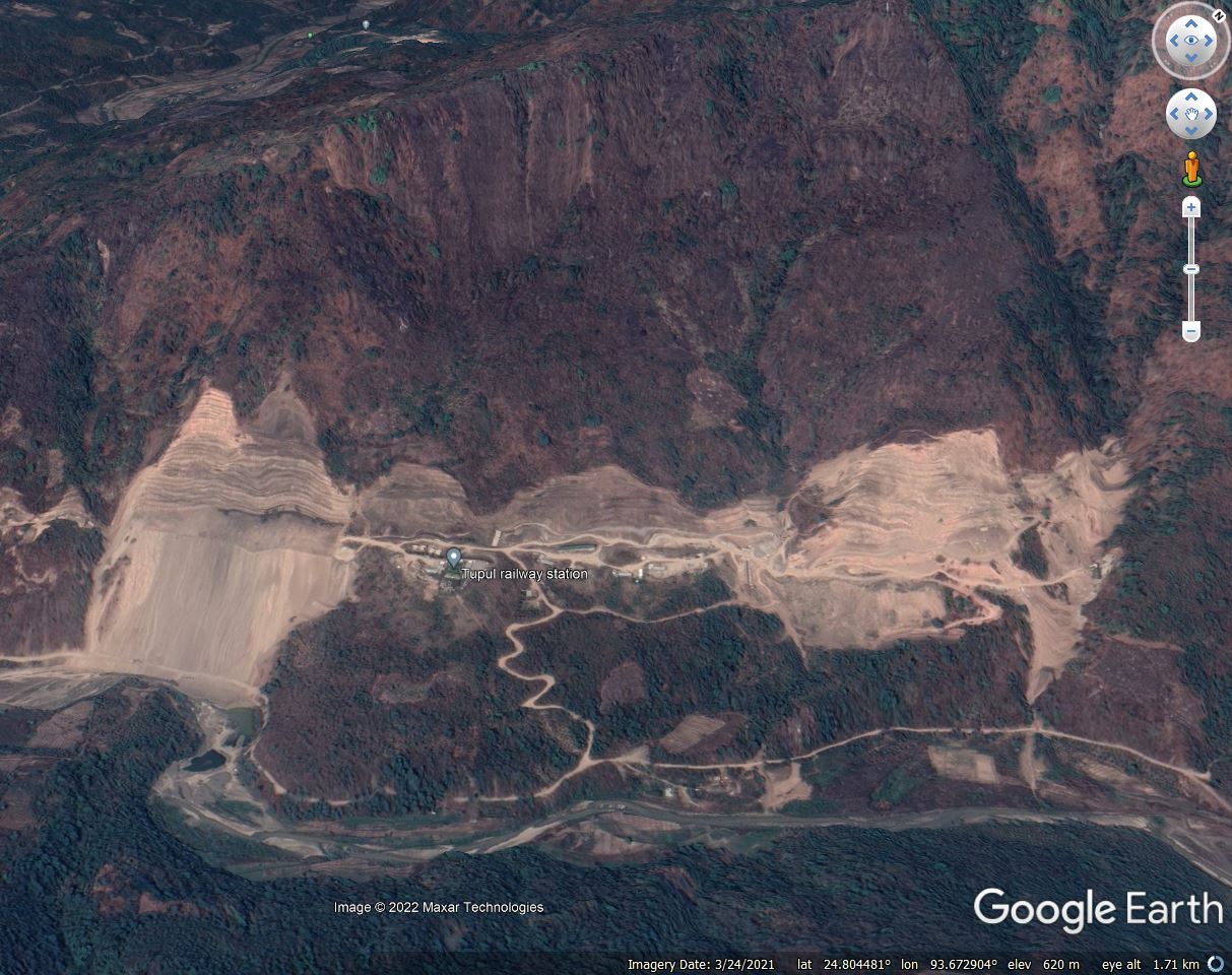
A Google Earth image of the site of the 30 June 2022 landslide at Tupul in northern India.
.
If losses from these types of landslides are to be reduced then there is a need for an honest conversation about the likely causes.
7 July 2022
The role of climate change in the May 2022 landslides in Pernambuco, Brazil
The role of climate change in the May 2022 landslides in Pernambuco, Brazil
On 27 and 28 May 2022 the state of Pernambuco in Brazil suffered exceptional rainfall that triggered deadly landslides, most particularly in the city of Recife. I wrote about these landslides at the time – the final toll is thought to have been 133 people, the large majority of whom died in landslides. Once again we have seen a landslide disaster caused by short duration, high intensity rainfall. As is often the case in these accidents, there has been discussion about the role of climate change.
This is the aftermath of one of the landslides:-
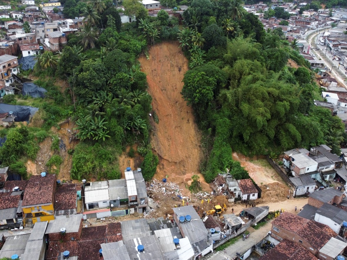
A landslide in Recife, Pernambuco, Brazil after the May 2022 extreme rainfall event. Image by Diego Nigro/Reuters via CBC.
.
The World Weather Attribution initiative is a consortium of universities and the Red Cross / Red Crescent, which focuses on using robust, peer reviewed methods to establish the role of climate change in extreme weather events. Earlier this week the consortium released results of a study into the landslides at Pernambuco. The focus of their study was 7-day and 15-day rainfall in the land areas affected by the heavy rainfall, based on the analysis of 75 rain gauge stations in the affected area.
The results are interesting. The rainfall lies in the range of 1-in-500 to 1-in-1000 year chance event. The team has noted that:-
“combining observations with our physical understanding of the climate system we conclude that human-caused climate change is, at least in part, responsible for the observed increases in likelihood and intensity of heavy rainfall events as observed in May 2022.”
They also conclude that the intensity of the rainfall is likely to have been increased by the impacts of climate change.
The evidence that climate change is placing a significant role in these extreme events is mounting. It is good though to see that the report highlights that a disaster is the consequence of the physical event and the vulnerability of the population. In poor areas of Recife this structural vulnerability is acute:-
The extreme nature of the floods made it so that exposure was the main determinant of impact, although long-term impacts and recovery will likely be mediated by socio-economic, demographic and governance factors. An increase in urbanisation, especially unplanned and informal in low-lying flood-prone areas and steep hillsides have increased the community exposure to these hazards. While forecasts and warnings were provided, it is unclear to what extent these informed anticipatory or early action that could have reduced the impacts.
Disasters are complex events, being exacerbated by climate change. Reduction is loss mostly occurs through measures that reduce exposure and vulnerability.
5 July 2022
The Tupul landslide: understanding the site
The Tupul landslide: understanding the site
Recovery works continue at the site of the 30 June 2022 Tupul landslide in Manipur, India. News reports at the end of 4 July 2022 indicate that the bodies of 47 victims have now been recovered, with a further 14 people missing, two of whom are soldiers.
Meanwhile, my post yesterday has prompted the unearthing of some further videos of interest. Loyal reader Ryukai has highlighted a video collected immediately after the landslide that captures the start of water flow over the landslide dam:-
.
A third video captures small collapses occurring in the head scarp area:-
.
Inevitably, questions are now being asked about the degree to which this landslide should have been anticipated and could have been prevented. For example, the Times of India has an article that points out details from Geological Survey of India report about landslides in the Tupul area, completed in 2018-19:-
While it may take some time to pinpoint the exact cause of the Tupul incident, the GSI had found that out of 170 landslides that occurred between 2011 and 2017, “most have occurred in extensive slope cut during construction of road/railway line. Out of 170 recorded slides, only 30 slides were on natural slopes abd tthe rest were of anthropogenic origin…The GSI report said even “railweay is at risk” on NH37, Imphal-Jiribun highway, because of “cutting of slope for railway line and increase in pore water pressure reducing the conhesive strength of the overburden materials”.
Whilst one might quibble at some of the detail here, the overall message is absolutely clear. This is landslide-prone territory, and slope cutting is exacerbating the situation. Back in 2020, concerns about this project were raised by the Centre for Financial Accountability, again citing the GSI report:
“A geotechnical assessment of landslides along the Jiribam-Imphal Broad Gauge Line, between Barak and Tupul, was undertaken by the Geological Survey of India, North East Region. In their report, they noted: “The unauthorised and unscientific dumping of excavated earth and disposal of chemical and solid wastes must be strictly checked in the proximity of the villages to avoid loss of property and life including aquatic life in future.”
The assessment report further stated that uncontrolled sudden increase in the discharge of major rivers – including Ejei – had caused severe erosion of the rivers and their tributaries, which would pose a danger to nearby villages. “Change in existing land use, uncontrolled cutting and excavation of critical slopes during construction of new approach road, particularly close to habituation, makes the area vulnerable to landslides.”
So what of the specific site of the Tupul landslide? As I indicated yesterday, I believe that there were good reasons to be concerned about this site prior to the events of 30 June 2022. The image below is the 3D view of the slope complex in 2009, prior to construction. The location of Tupul railway station is marked – this is where the camp that was destroyed was located:-
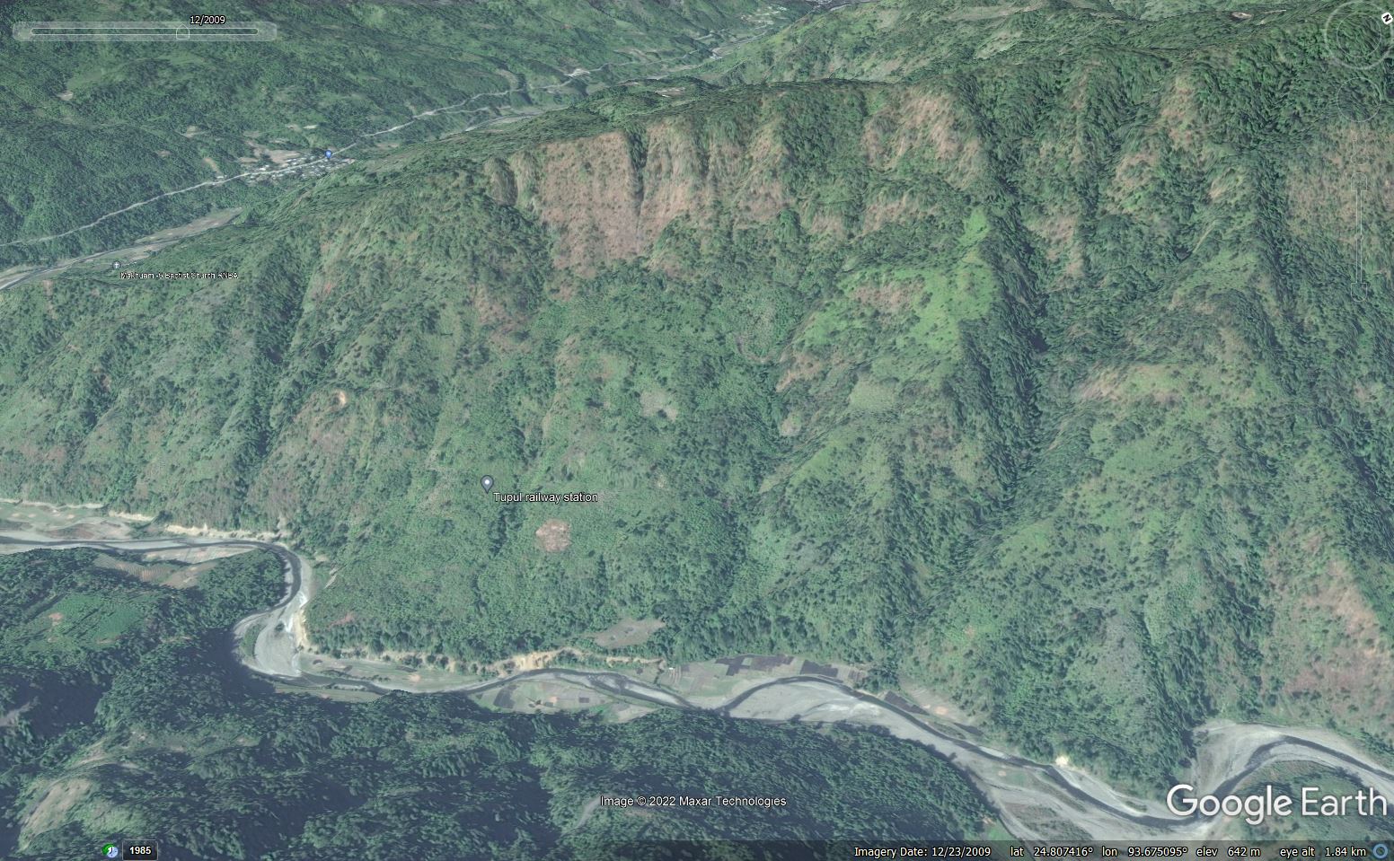
The site of the 30 June 2022 Tupul landslide in Manipur, India. Google Earth image from 2009.
.
I was a student of the wonderful Professor Denys Brunsden, a pioneer of applied geomorphology. He encouraged us to learn to read the landscape as the landforms indicate past and ongoing processes. At this site, there are multiple elements that to me indicate the likelihood that this slope is a relict (ancient) landslide. For instance, I would worry a great deal about those very steep slopes near to the ridge – does this indicate that material has slipped to expose them? Look at the uneven topography on the midslopes – could that be an indication of material deposited in a previous landslide? Why does the river have that sharp pair of bends on the left side of the image? Is this an indication that it has been pushed over by a landslide? Indeed, doesn’t the section of slope on which Tupul railway station is located look like an earthflow?
Is there a sign of a secondary failure in the slopes above the railway station – possible an arcuate but vegetated scarp?
If this is true then the slope on the left of the section is of particular concern. The river is actively eroding the toe and it is steeper than the adjoining slopes. There may be some signs of instability on the lower slope.
Of course all of this needed to be confirmed with detailed mapping from aerial photographs and on the ground, including analysis of the materials. Was that analysis undertaken, I wonder?
But once you are sensitised to the possible landforms at this site the construction approaches start to look somewhat courageous:-
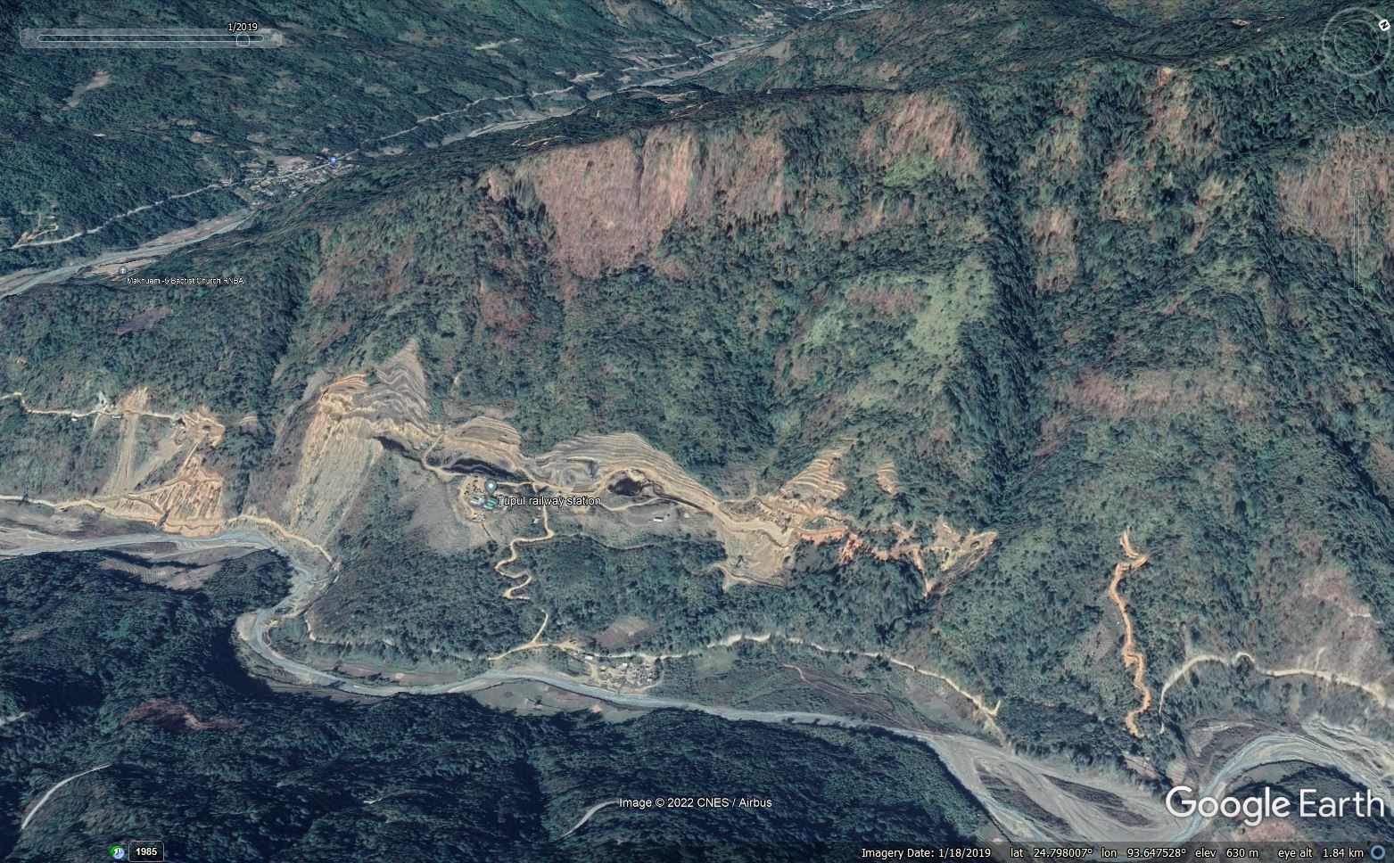
The site of the 30 June 2022 Tupul landslide in Manipur, India. Google Earth image from January 2019.
.
Look in particular at the area around Tupul railway station, where the landslide occurred, this time from an overhead view:-
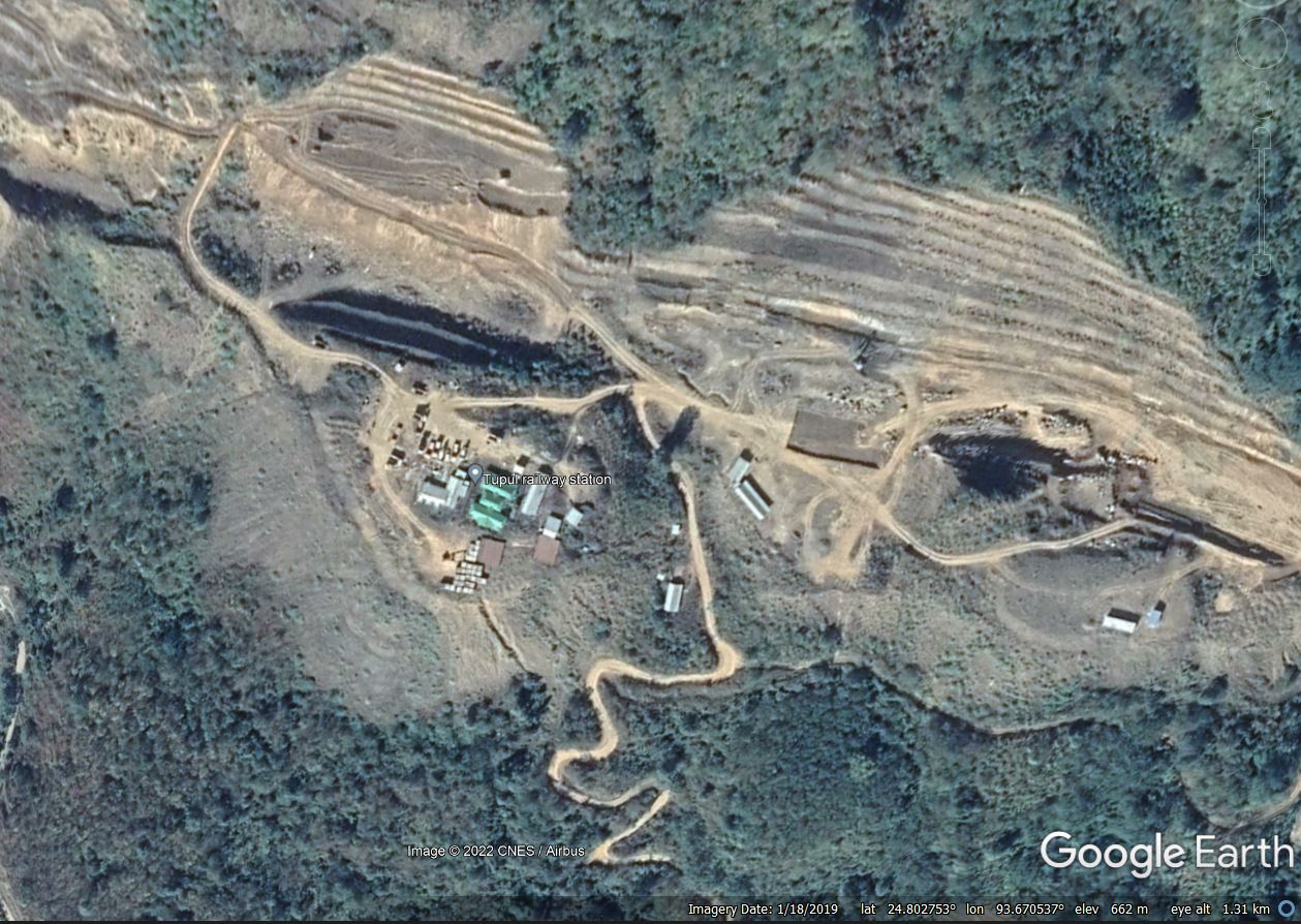
The site of Tupul railway station, part of the 30 June 2022 Tupul landslide in Manipur, India. Google Earth image from January 2019.
.
The lobe that I identified as a potential earthflow has been cut, and the slope has been benched. Downslope, spoil has been tipped to create a bench, loading the lower slope. If this location was an ancient landslide then both of these acts could have potentially destabilised the slopes.
Of course once again this is speculation, and a proper investigation is needed. The Print reports that the Chief Minister of Manipur, N. Biren Singh, has indicated that “the tragedy necessitated a “relook” at the railway project.”
“The Manipur hill soil is very soft, the railway people have the expertise, but unfortunately this kind of incident has taken place and they need to relook… this target of railway reaching Imphal by December 2023 will be delayed,” he had said.
I am unsure what a “relook” actually means. I hope it indicates a detailed investigation as to what caused the Tupul landslide, and a lessons learnt for the remainder of the railway alignment. Time will tell.
4 July 2022
Tupul: a landslide disaster in Manipur, India
Tupul: a landslide disaster in Manipur, India
On 30 June 2022 a very large landslide occurred at Tupul in Noney district of Manipur in Northern India. As of 3 July 2022 the confirmed toll was 42 people, with a further 20 people reported to be missing. A total of 18 people have been rescued. The majority of the fatalities consisted soldiers who were accommodated on the site of the landslide, with reports that they were from the 107 Battalion of the Territorial Army. The prospect of any further survivors is extremely low.
The best image that I have seen of the landslide was tweeted by Karma Paljor:
https://twitter.com/Karma_Paljor/status/1542833204515598337
.
There is also good drone footage on the following Youtube video (which has some annoying music):-
.
The drone footage confirms that the valley is not blocked by the landslide, which was an earlier concern. Indeed, it shows operations underway to widen the spillway.
The location of the landslide is 24.804, 93.674. The Google Earth image below shows the site on 24 March 2021:-
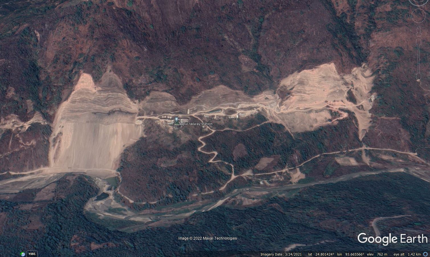
Google Earth image of the site of the 30 June 2022 Tupul landslide in India.
.
The image shows extensive slope works being undertaken at Tupul – this is for the construction of the Jiribam to Imphal railway line, which is planned to be completed by December 2023. Some of the works shown in the image appear to demonstrate questionable construction approaches, including large amounts of sediment being released into the river system.
The section of slope that has failed is shown below:-
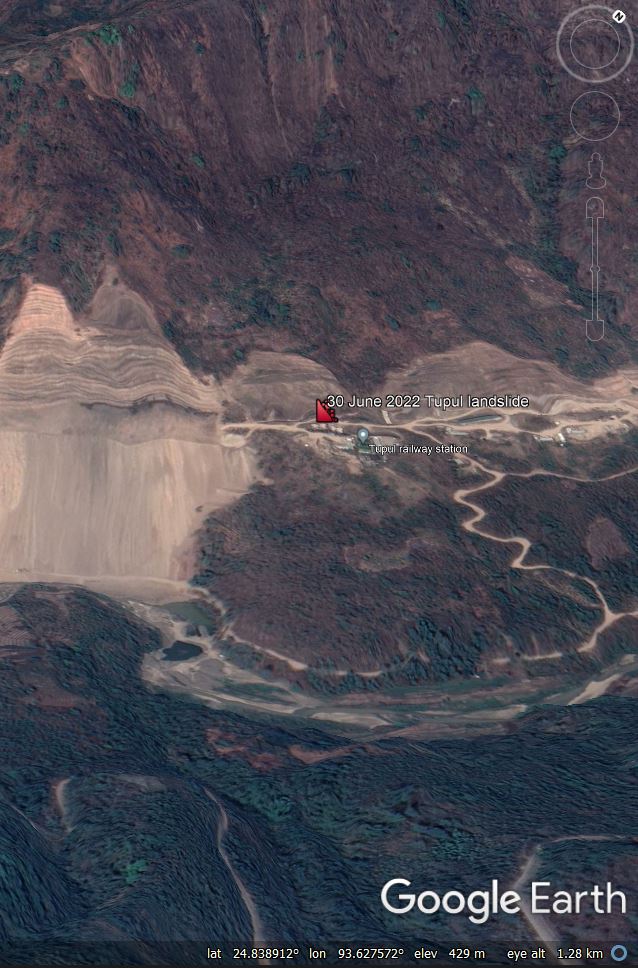
Google Earth image of the section of slope that failed during the 30 June 2022 Tupul landslide in India.
.
There are a number of aspects of this site, prior to the failure, that give me cause for concern, including the very steep upper part of the slope, the lobate form of the lower slopes and the large bend in the river. I would like to see the engineering geomorphological and geological interpretation of this site that was surely (?) undertaken prior to construction.
The section that has collapsed had been cut, so inevitably this must be the leading potential cause of the landslide. The width of the landslide appears to correspond closely to the section of cut slope, which may be an indication of process and causation. I have tried to annotate the image from Karma Paljor to indicate the main features – of course this is highly speculative:-
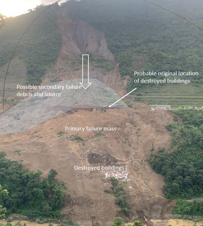
A speculative interpretation of the main features of the Tupul landslide, based on the image tweeted by Karma Paljor.
.
My initial (speculative) interpretation is that the cut slope failed, creating the large debris mass seen in the foreground of the image. The location of the destroyed buildings gives a sense of the movement direction and distance. The area that I have shaded appears to be a secondary failure from higher up the slope, probably because of a loss of support. This is a deep seated collapse that may have implications for the stability of the other parts of the slope. This scar has then been partially infilled by smaller failures around the steep backscarp. These are likely to continue for some time.
Note the water flowing down the rear scarp. The main part of the SW summer monsoon will occur over the coming weeks. A key concern right now must be the stability of the other cut slopes at this site.
Finally, it goes without saying that this landslide should be investigated independently and in a transparent manner, with the outcomes published and lessons learnt.
30 June 2022
The Hallett Peak rockslide in Rocky Mountain National Park
The Hallett Peak rockslide in Rocky Mountain National Park
On 28 June 2022 at about 4:30 p.m. local time a large rockslide occurred on the side of Hallett Peak in Rocky Mountain National Park in Colorado, USA. The event was captured on two videos that have been circulating on social media. The first was captured by Ryan Albert and posted onto Instagram by the Boulder Guide to Mount Evans and RMNP. I recommend visiting their Instagram site to see the video in full, but it can also be seen on the Youtube video below:-
.
The other video was captured by William Mondragon, and was also posted to Instagram. Once again I recommend going to their site to view the video, but it is also on Youtube, embedded in a news report:-
.
I admire the courage of William, standing below a failing slope as it moves towards them. Fortunately it did not move into a rapid movement phase.
The landslide appears to have occurred at 40.301, -105.681, as shown in the Google Earth imagery below:-
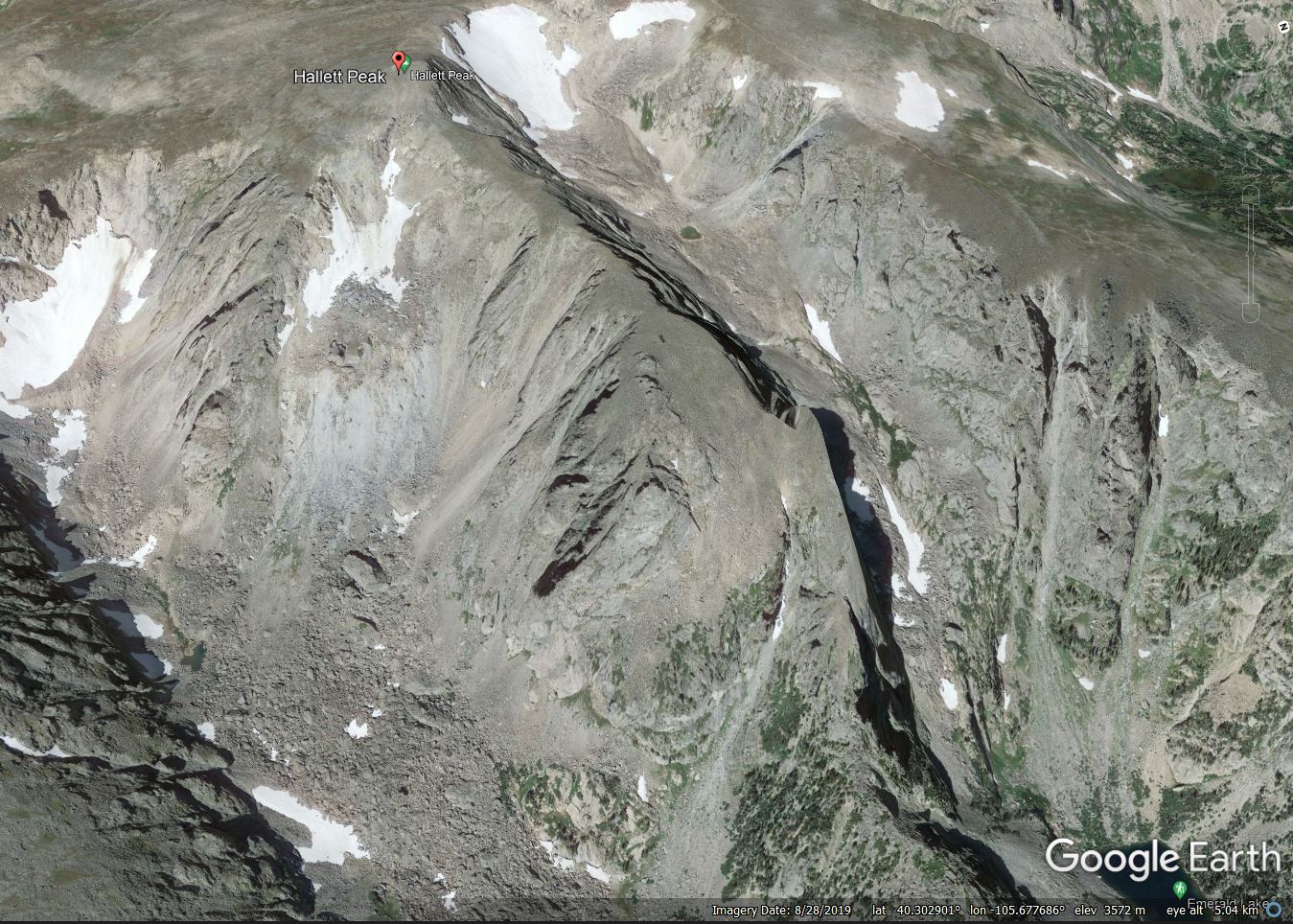
Google Earth image of the site of the 28 June 2022 rockslide on Hallett Peak in Colorado, USA.
.
It appears that the mass that has failed is the large accumulation of debris sitting just below the snow patch in the centre left of the image. My initial interpretation is that this is a relict (i.e. pre-existing) landslide, and thus the event of two days ago is a reactivation. This might have occurred because of progressive weakening of the mass, erosion of the toe or a failure from the rock wall onto the debris. Previous studies have suggested that high mountain rockslides often occur in the spring and early summer (e.g. Etzelmüller et al. 2022).
The rocky debris in the valley suggests to me that this is an area that has seen significant rockslide activity in the past, with some events showing greater mobility than was the case here.
At the moment I have not been able to track down any satellite imagery of the area since the rockslide occurred, but this should become available in the coming days. This will give us a true sense of the scale of the movement.
.
Acknowledgement and reference
Thanks to various people who highlighted this to me, and in particular to Corey Scheip, who tracked down the original Instagram posts.
Etzelmüller, B., Czekirda, J., Magnin, F., Duvillard, P.-A., Ravanel, L., Malet, E., Aspaas, A., Kristensen, L., Skrede, I., Majala, G. D., Jacobs, B., Leinauer, J., Hauck, C., Hilbich, C., Böhme, M., Hermanns, R., Eriksen, H. Ø., Lauknes, T. R., Krautblatter, M., and Westermann, S., 2022, Permafrost in monitored unstable rock slopes in Norway – new insights from temperature and surface velocity measurements, geophysical surveying, and ground temperature modelling Earth Surface Dynamics, 10, 97–129, https://doi.org/10.5194/esurf-10-97-2022.
28 June 2022
Always fly with the window blinds up: the West Salt Creek landslide
Always fly with the window blinds up: the West Salt Creek landslide
Over the last couple of weeks I have been in the USA and Canada in a series of meetings. The trip involved a fair amount of flying – not the easiest thing to do at the moment, but that’s a different story. On one leg I flew from the East to the West coast in a day time flight.
The USA is a stunningly beautiful country, so a long transcontinental flight is a treat. I am always slightly depressed that most people fly with the window blinds up – indeed on this flight the majority of the blinds were closed from boarding to landing. I was staring out the window when, by complete coincidence, I saw this:-

The West Salt Creek landslide in Colorado.
.
This is the failure that has become known as the West Salt Creek landslide, which occurred in Colorado on 25 May 2014. I was able to get a better image of the landslide:-
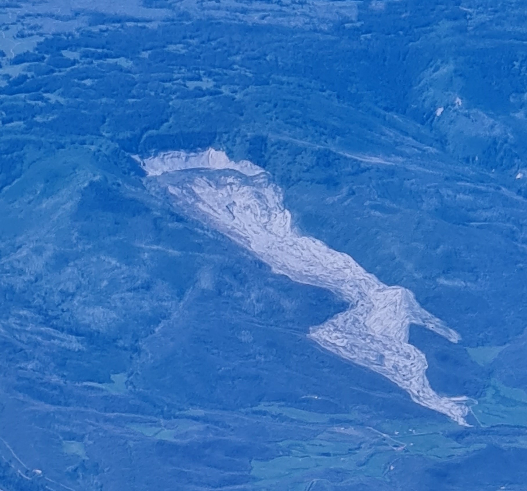
The West Salt Creek landslide in Colorado
.
The landslide has been described in detail in a report published by the Colorado Geological Survey (White et al. 2015). The slide is about 4.5 km in length, involving 29 million cubic metres of rock and debris. It is estimated that the landslide reached a peak velocity of 72 km/h. Secondary failures increased the volume to about 55 million cubic metres.
Sadly three men – Wes Hawkins, Clancy Nichols and Danny Nichols – were killed in the landslide. Their remains have not been recovered from the site.
On the same trip I saw two other features of interest. First is this large tailings facility:-
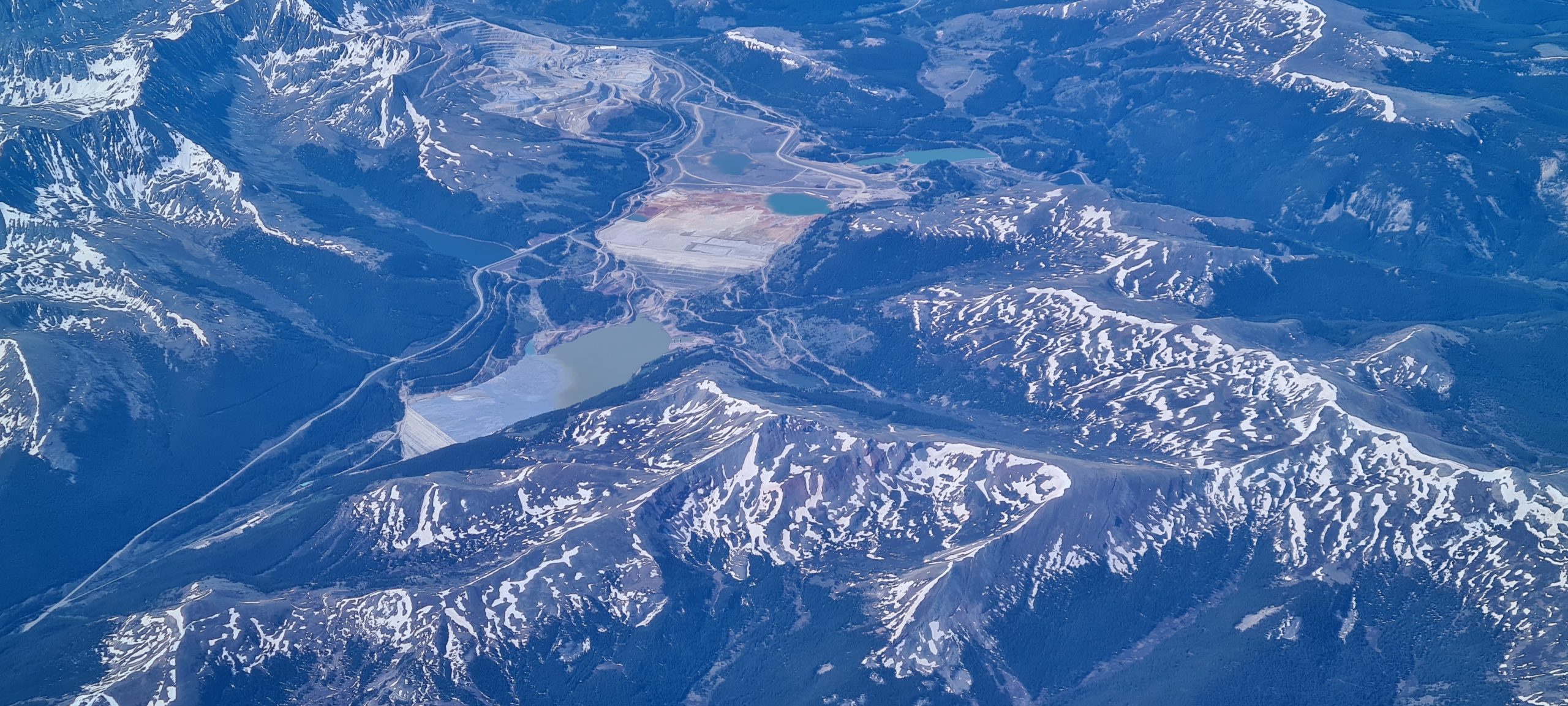
A tailings facility in the US.
.
And second is this fascinating ancient landslide in the mountains:-
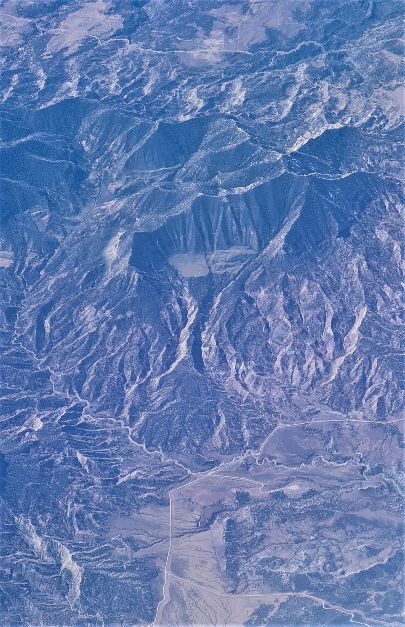
An ancient landslide in the US.
.
I’m sure that this ancient landslide has been studied properly – does anyone know the details? I would love to visit.
.
Reference
White, J.L., Morgan, M.L. and Berry, K.A. 2015. The West Salt Creek Landslide: A Catastrophic Rockslide and Rock/Debris Avalanche in Mesa County. Colorado Colorado Geological Survey, 45 pp.
9 June 2022
The Black Lake landslide at Thetford Mines in Quebec
The Black Lake landslide at Thetford Mines in Quebec
In the last few days a video captured by a drone of the aftermath of the 2009 Black Lake rockslide at Thetford Mines in Quebec, Canada, has gone viral. The video was captured by Optique video in 2021, and a very dramatic backing track has been added. You should be able to view the footage below:-
.
This landslide is located at 46.026, -71.363, and is very clear on Google Earth:-
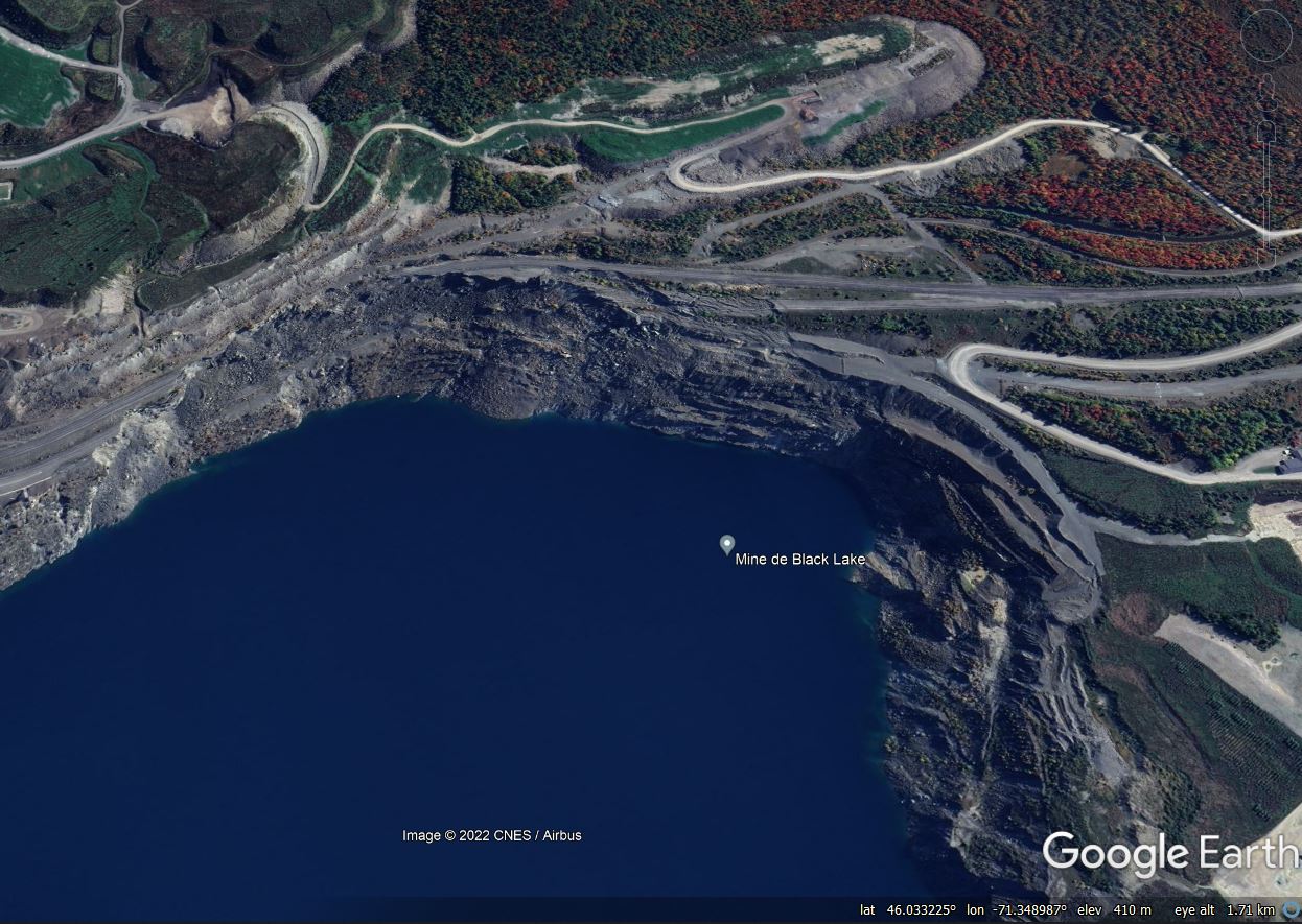
Google Earth image of the Black Lake landslide at Thetford Mines in Quebec, Canada.
.
The landslide destroyed a section of Route 112 in the area of the Lac d’amiante asbestos (serpentinised peridotite) mine, which closed in 2011. The road was rerouted, with a new section opened in 2015.
The development of the landslide is quite interesting. A Google Earth image from May 2009 shows the road in an intact state, but some of the benches below the highway in the pit wall had collapsed:-
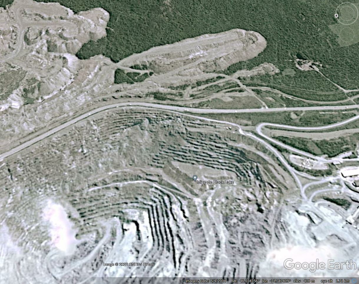
Google Earth image from May 2009 showing the site of the Black Lake landslide at Thetford Mines in Quebec, Canada.
.
By January 2012 the slope failure had retrogressed and damage to the road was evident. In one location a section of the side of the road had collapsed, and in others large tension cracks had developed:-
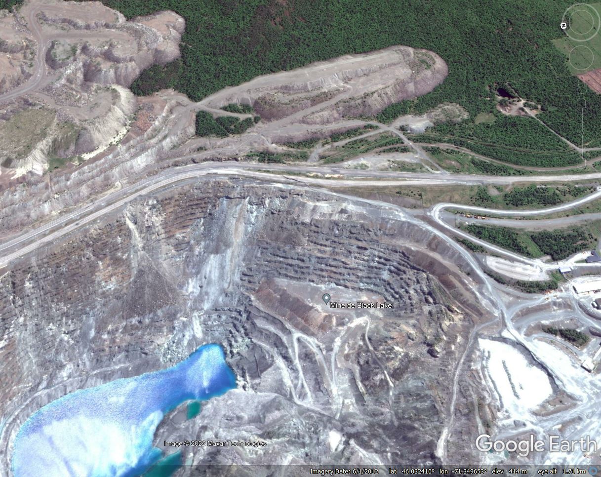
Google Earth image from June 2012 showing the site of the Black Lake landslide at Thetford Mines in Quebec, Canada.
.
The image from October 2016 shows that complete failure had occurred, whilst the mine was flooded at the end of operations:-
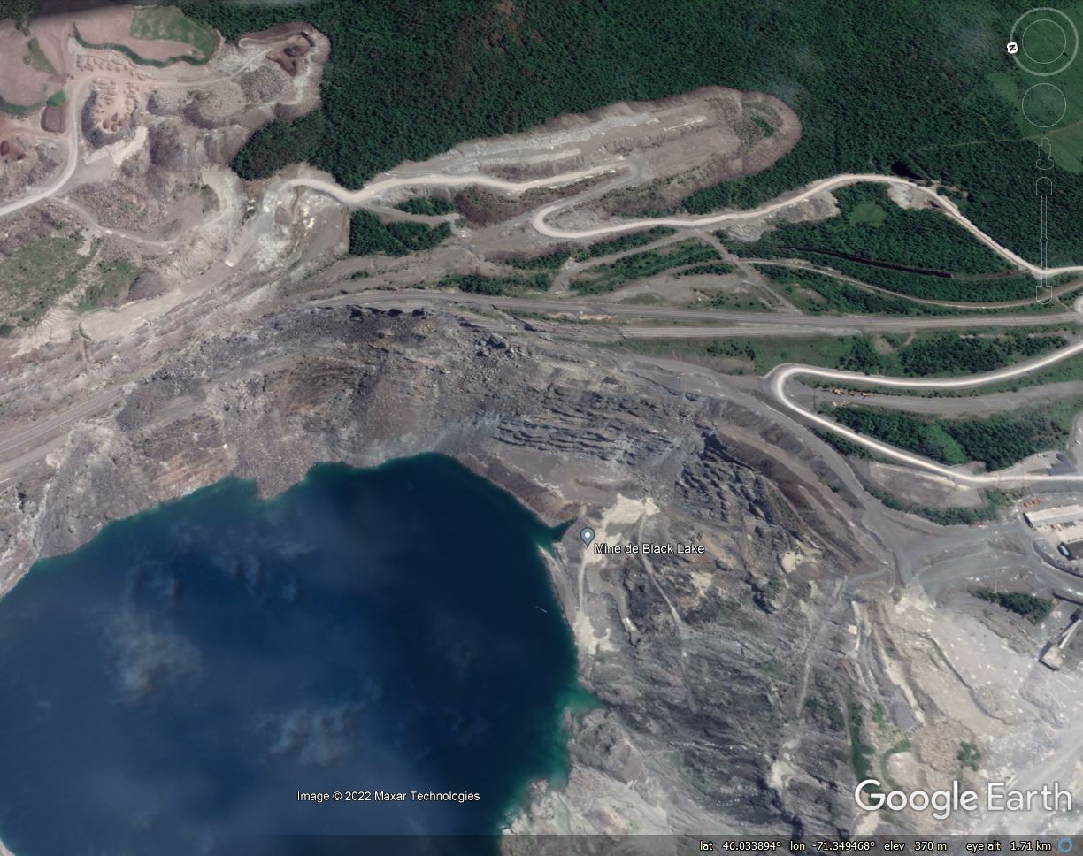
Google Earth image from August 2016 showing the fully developed Black Lake landslide at Thetford Mines in Quebec, Canada.
.
The Black Lake landslide is described in a paper (Amoushahi et al. 2018) published in the Canadian Geotechnical Journal, which analysed the stability of the slope. The study, and others, indicated that about 50 million cubic metres of rock slipped over a lateral extent of about 1,100 metres. Approximately 70 m of vertical movement was observed at the crown of the slope.
.
Reference
Amoushahi, S., Grenon, M., Locat, J. and Turmel, D. 2018. Deterministic and probabilistic stability analysis of a mining rock slope in the vicinity of a major public road — case study of the LAB Chrysotile mine in Canada. Canadian Geotechnical Journal. 55 (10): 1391-1404. https://doi.org/10.1139/cgj-2017-0298
8 June 2022
San Carlos de Bariloche: a deadly slope failure in Argentina
San Carlos de Bariloche: a deadly slope failure in Argentina
On Monday 6 June 2022 a slope failure struck a hotel located close to the town of San Carlos de Bariloche in Argentina, killing at least one person. According to reports, the slope impacted on the rear of Hotel Villa Huinid, killing a 78-year-old tourist, injuring three other people and leaving two missing. The person who lost his life, and the two that are missing, were reportedly in rooms at the rear of the hotel. There is good drone footage of the site, and some images of the aftermath, on Youtube.
The best image that I have found of the site has been posted by Rio Negro:-
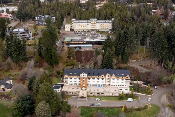
The aftermath of the landslide at Hotel Villa Huinid near to San Carlos de Bariloche in Argentina. Image by Marcelo Martinez via Rio Hegro.
.
The same source has also posted a view of the landslide crown:-
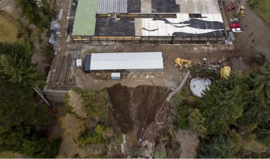
The crown of the landslide at Hotel Villa Huinid near to San Carlos de Bariloche in Argentina. Image by Marcelo Martinez via Rio Hegro.
.
In the second image note the wall of gabian baskets on the left side, and also on the right side of the landslide crown. On first inspection the material looks like fill, although this needs confirmation. The site is located at -41.133, -71.341, for which there is a really good archive of images on Google Earth. The image below, from 2019, appears to show significant works being undertaken on the slope:-
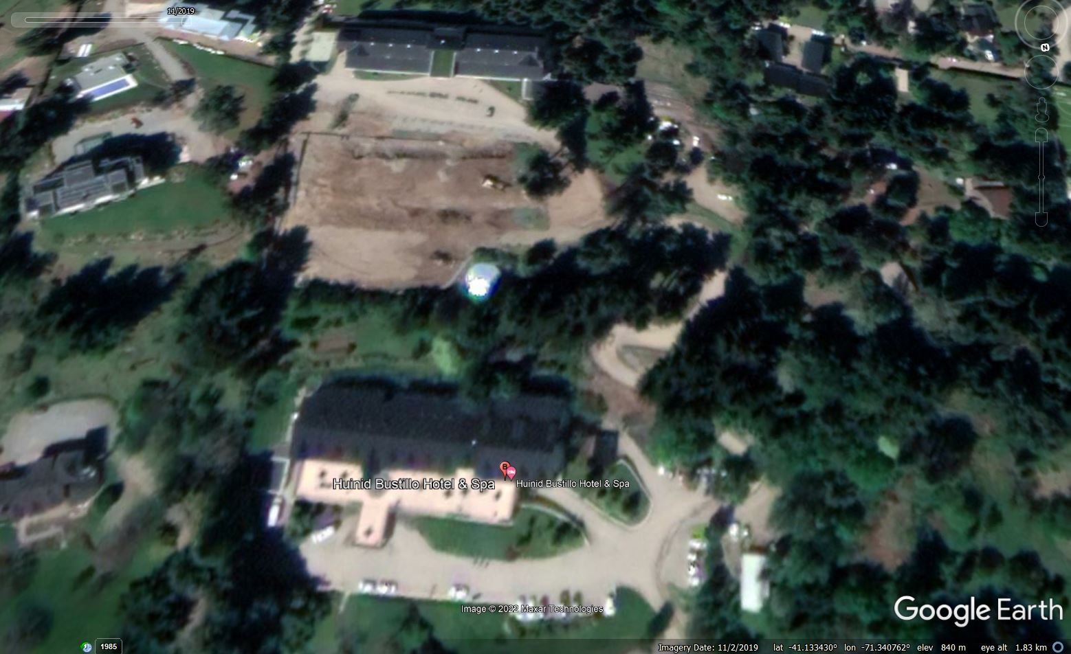
Google Earth image from November 2019 showing the site of the landslide at t Hotel Villa Huinid near to San Carlos de Bariloche in Argentina. It appears that works were underway on the slope.
.
My initial and of course speculative interpretation is that a new platform was constructed to allow a new building to be built. It appears to be the edge of this platform that has failed. It is intriguing to note that it appears that there might have been some construction occurring at the time of the landslide.


 Dave Petley is the Vice-Chancellor of the University of Hull in the United Kingdom. His blog provides commentary and analysis of landslide events occurring worldwide, including the landslides themselves, latest research, and conferences and meetings.
Recent Comments