30 June 2022
The Hallett Peak rockslide in Rocky Mountain National Park
Posted by Dave Petley
The Hallett Peak rockslide in Rocky Mountain National Park
On 28 June 2022 at about 4:30 p.m. local time a large rockslide occurred on the side of Hallett Peak in Rocky Mountain National Park in Colorado, USA. The event was captured on two videos that have been circulating on social media. The first was captured by Ryan Albert and posted onto Instagram by the Boulder Guide to Mount Evans and RMNP. I recommend visiting their Instagram site to see the video in full, but it can also be seen on the Youtube video below:-
.
The other video was captured by William Mondragon, and was also posted to Instagram. Once again I recommend going to their site to view the video, but it is also on Youtube, embedded in a news report:-
.
I admire the courage of William, standing below a failing slope as it moves towards them. Fortunately it did not move into a rapid movement phase.
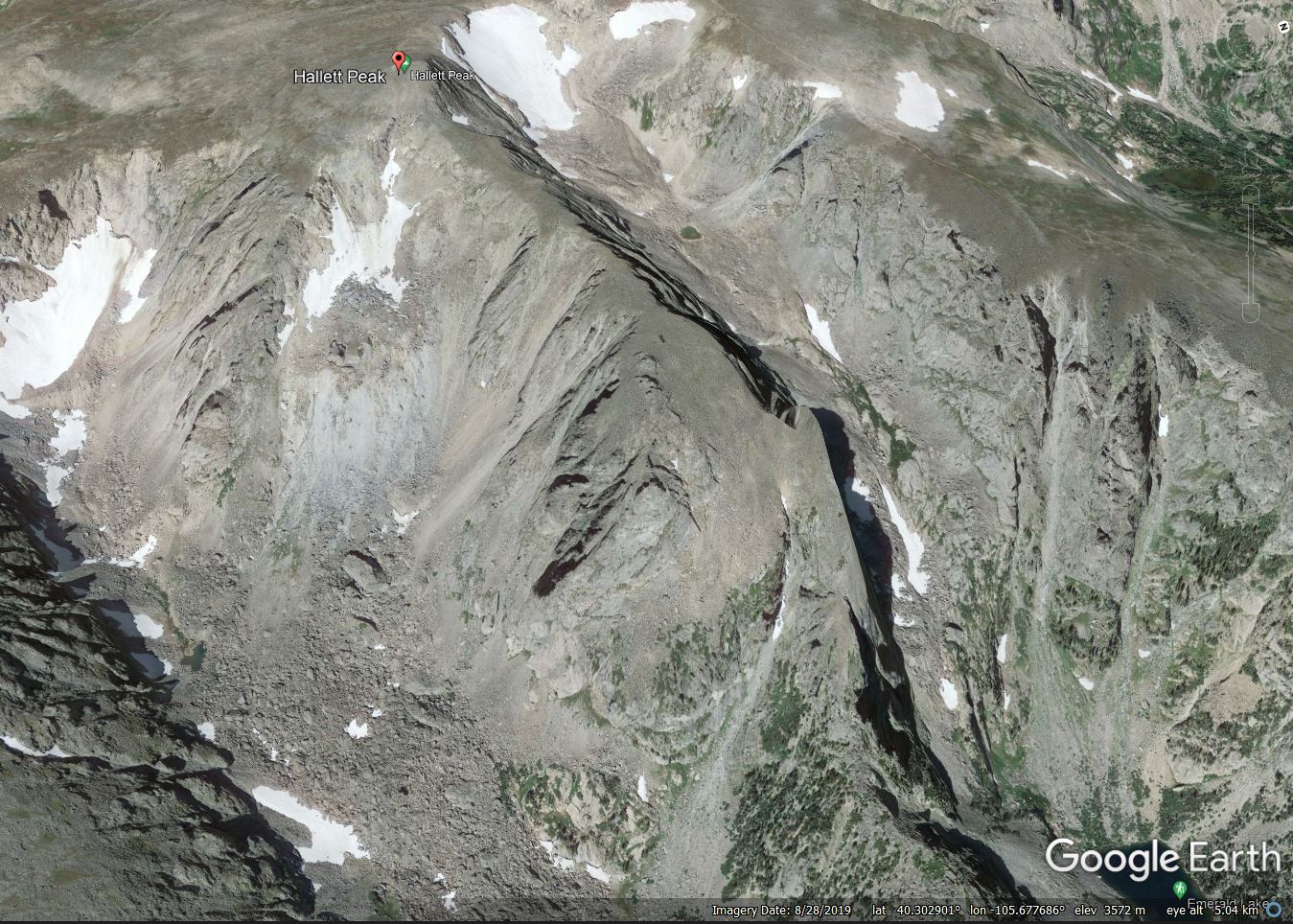
The landslide appears to have occurred at 40.301, -105.681, as shown in the Google Earth imagery below:-

Google Earth image of the site of the 28 June 2022 rockslide on Hallett Peak in Colorado, USA.
.
It appears that the mass that has failed is the large accumulation of debris sitting just below the snow patch in the centre left of the image. My initial interpretation is that this is a relict (i.e. pre-existing) landslide, and thus the event of two days ago is a reactivation. This might have occurred because of progressive weakening of the mass, erosion of the toe or a failure from the rock wall onto the debris. Previous studies have suggested that high mountain rockslides often occur in the spring and early summer (e.g. Etzelmüller et al. 2022).
The rocky debris in the valley suggests to me that this is an area that has seen significant rockslide activity in the past, with some events showing greater mobility than was the case here.
At the moment I have not been able to track down any satellite imagery of the area since the rockslide occurred, but this should become available in the coming days. This will give us a true sense of the scale of the movement.
.
Acknowledgement and reference
Thanks to various people who highlighted this to me, and in particular to Corey Scheip, who tracked down the original Instagram posts.
Etzelmüller, B., Czekirda, J., Magnin, F., Duvillard, P.-A., Ravanel, L., Malet, E., Aspaas, A., Kristensen, L., Skrede, I., Majala, G. D., Jacobs, B., Leinauer, J., Hauck, C., Hilbich, C., Böhme, M., Hermanns, R., Eriksen, H. Ø., Lauknes, T. R., Krautblatter, M., and Westermann, S., 2022, Permafrost in monitored unstable rock slopes in Norway – new insights from temperature and surface velocity measurements, geophysical surveying, and ground temperature modelling Earth Surface Dynamics, 10, 97–129, https://doi.org/10.5194/esurf-10-97-2022.


 Dave Petley is the Vice-Chancellor of the University of Hull in the United Kingdom. His blog provides commentary and analysis of landslide events occurring worldwide, including the landslides themselves, latest research, and conferences and meetings.
Back in the 30’s, my dad was a counselor at a boys camp nearby. He participated in retrieving the body of a climber who had died on Hallett Peak. It’s a popular climb, amazing no one was injured in this rock fall.
Dear Dave:
Thank you for sharing this event.
I’d seem to me that the main mass below the large boulders in the Google Earth image is a rock glacier. Perhaps a very unstable one, which could have triggered the rock fall on its front.
Regards,
Felipe
High temperatures 2 to 3 weeks ago caused increased snow melt and flooding in Rocky Mountain National Park, could have contributed to the deep seated failure plane of the reactivated landslide.
https://www.cpr.org/2022/06/14/snowmelt-flooding-closes-rocky-mountain-national-park-roads-tubing-restrictions/
USGS posted some great info via Twitter about the signal that was recorded ~100sec before the landslide. A M1.5 earthquake-like signal. Good stuff!
Whoops forgot the link!
https://twitter.com/usgs_quakes/status/1542614684569718784
Any updates?
It looks like the regional seismic stations record a defined signal most workday afternoons. (6-27, 6-28, 6-29, 7-1, etc.) Could this be from a local mine/quarry blast? Does the seismic signal on 6-28 indicate a huge rock impacting from the above headwall to reactivate, in combination with increased runoff and weathering, the historical landslide debris? Here is a preliminary update provided by the national park.
https://www.nps.gov/romo/what-s-happening-below-hallett-peak-in-chaos-canyon-and-lake-haiyaha.htm