
21 May 2015
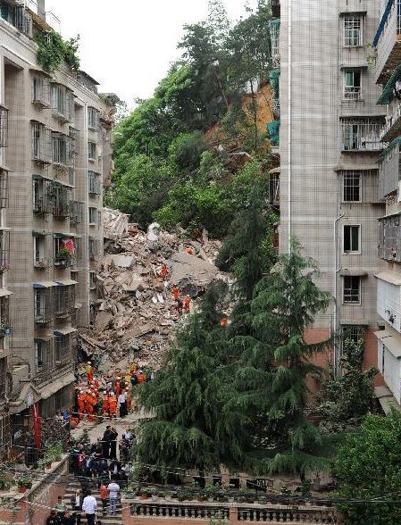
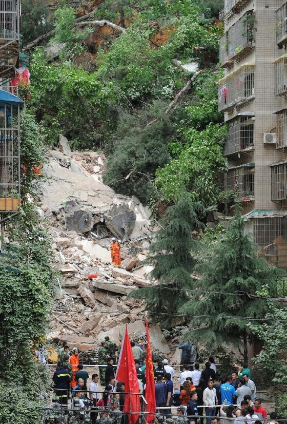
Guiyang, China: a landslide demolishes an apartment block, 16 people killed or missing
A landslide in Guiyang, China
A landslide yesterday morning in the Yunyan District of Guiyang, the capital city of Guizhou demolished completely an apartment building that was home to 114 people. Of these people, eight bodies have been recovered whilst eight remain missing. The authorities report that their mobile phone signals have been traced to the rubble.
It is clear that the building collapse at Guiyang was triggered by a landslide, caused by heavy rainfall. Some of the images show the collapsed block with the landslide behind. Both of these images are from Xinhua:
.
Judging by the images it appears that the building was connected to another, which fortunately did not collapse.
Such events are rare, but not unknown. The two best known examples are:
- The 1972 Po Shan Road landslide in Hong Kong, which killed 67 people. I featured the animation of this landslide in a previous post.
- The 1993 Highland Towers landslide in Taman Hillview, Kuala Lumpur, which killed 48 people
20 May 2015
The timing of the landslide season in Nepal
Timing the landslide season in Nepal
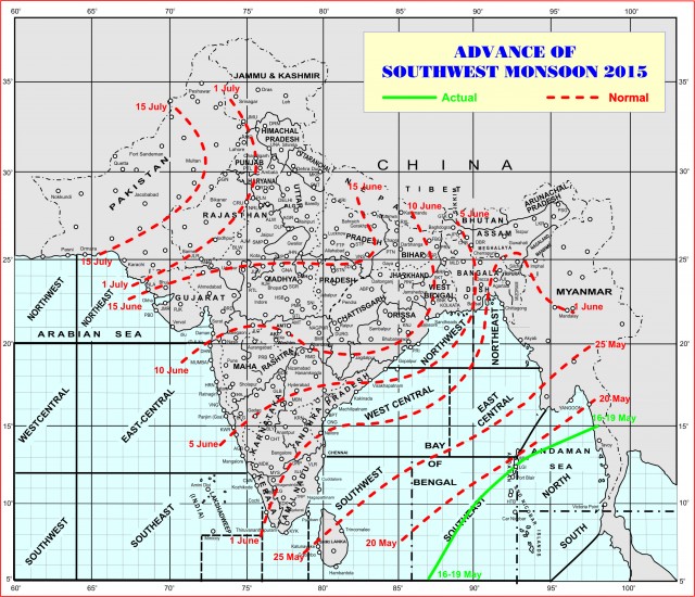
In a previous post I highlighted the threat posed by landslides in the SW monsoon in Nepal. A key question now is the timing – i.e. when will the rainy season (i.e. the landslide season) start? The IMD has a tracking map for the advance of the monsoon – at the time of writing the monsoon front is lying to the SW of India in the Andaman Sea, and the advance looks to be about normal for the time of year:
.
Based upon the timings on this map the rains might be expected to reach the eastern part of Nepal on about 5th June, and to have covered the entire county by about 20th June. These are average figures of course, so there may be considerable variability. But of course the arrival of the monsoon front is not necessarily the start of the landslide season. Landslides can be triggered by pre-monsoon rainfall (especially convective events), and the heavy monsoon rainfall may not be associated with the arrival of the monsoon front. So I have been looking at my Nepal landslide database. In the graph below I have plotted by year for the period from 2004 to 2014 inclusive the cumulative number of fatal landslides in Nepal:-
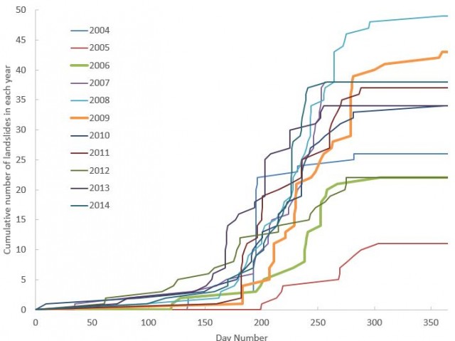
Cumulative number of fatal landslides in Nepal (author’s data)
.
Today (20th May) is day number 140, so it is clear that the main landslide season has yet to start. In most years the number of fatal landslides starts to increase at around about day 160 (about 8th June), with the main focus starting from about day 180 (28th June). So the main threat will start in about three weeks from now, and will intensify towards the end of next month. The landslide season typically ends at about day 280, i.e. somewhere around early October. Note that there is a great deal of variation between years both in terms of timing and the number of events.
I have highlighted two curves – 2006 and 2009. These were both years that represented the start of El Nino events – a medium-sized event in 2009-10 and a weak event in 2006-7. Interestingly both years saw a later than average start to the landslide season. We are currently in weak El Nino conditions. I am unsure as to whether this is significant.
19 May 2015
Salgar, Antioquia, Colombia: a landslide killed at least 63 people yesterday
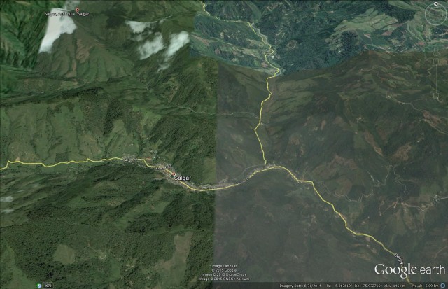
Salgar, Antioquia, Colombia
Early yesterday morning, a landslide struck the small town of Salgar in Antioquia, Colombia. Latest reports (in Spanish) are that at least 63 people were killed. At least 37 people have been injured and an unknown number are missing.
The event appears to have been a debris flow, triggered by heavy rainfall, that tore through the small town in the floor of the valley. Although the exact location of this event is not yet clear, the Salgar area is characterised by villages lying in the floor of valleys in quite steep upland areas:
Google Earth
.
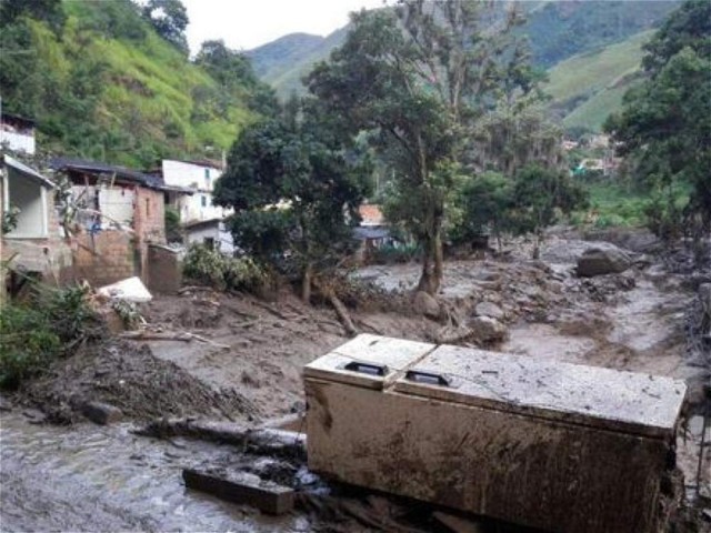
Images from the scene – there is a good gallery on the El Tiempo website – suggest that the flow may have been rapid and catastrophic:-
.
18 May 2015
Landslides in Nepal and the impact of the SW Monsoon
Landslides in Nepal and the SW Monsoon
As Nepal moves out of the emergency phase of the earthquake disaster and starts to transition into the recovery and reconstruction phases, attention is now turning to the potential impacts of the SW (summer) monsoon period. In particular, there is now real concern that the heavy rainfall that the monsoon brings may reactivate many landslides, and trigger a host of new failures as well. Based on experience from elsewhere, these concerns are valid.
Not entirely coincidentally, back in 2007 I wrote what is perhaps the definitive paper on the triggering of landslides by the monsoon in Nepal, based on a database of landslides that we constructed as part of the DfID Landslide Risk Analysis project. This paper, Petley et al. (2007), is available for download for free from the Natural Hazards journal website.
In the paper we demonstrated three key aspects of landslides in Nepal:
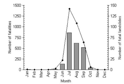
1. The SW Monsoon is the dominant factor:
This graph from my paper shows the monthly occurrence of landslides that cause loss of life in Nepal (the data is for 1978-2005 inclusive):
.
The trend is clear – landslides occur almost solely in the summer period, with low incidence in May, a few more in June (the data show that these are mostly in the last week of the month, and then increasing dramatically in July and remaining high for three months. The threat in the months ahead is clear.
2. The earthquake affected area is extremely landslide-prone:
Map A below shows the distribution of landslides that caused loss of life over the same period, plotted in terms of number of landslides per unit area:

.
Map B is the distribution of rainfall. It is clear that landslides are most serious in a swathe of Hill Districts in Central Nepal. This starts to look deeply worrying when compared with a map of the areas most seriously affected by the earthquake:
.
The coincidence between the area of intense landslides and the area affected by the earthquake is deeply worrying.
3. Nepal landslides are at their worst when the SW Monsoon across the whole region is weak.
This may seem like a perverse relationship, but we found that the worst years for landslides in Nepal occurred in years when the SW Monsoon for the whole region (as indicated by SASMI – an index of monsoon intensity) was low:
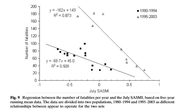
.
The reason that the data split into two groups is that the later values (with far higher losses from landslides) occurred after the start of the spate of road building in the mountains of Nepal, after which the occurrence of landslides increased dramatically. So, we might expect the landslide problem in Nepal to be particularly serious this year if the SW Monsoon across the whole region is particularly weak.
The India Meteorological Department has forecast that the SW Monsoon this year will be “below normal”.
Reference
Petley, D.N., Hearn, G.J., Hart, A., Rosser, N.J., Dunning, S.A., Oven, K., and Mitchell, W.A. 2007. Trends in landslide occurrence in Nepal. Natural Hazards 43:23–44. Download the PDF from here (no cost).
17 May 2015
Reports of a massive ice – rock avalanche in Akto County, Xinjiang, China?
A massive ice – rock avalanche in Akto County, Xinjiang, China?
The Chinese new agency Xinhua has some rather vague reports this morning of a massive “glacier collapse” in Akto County, Xinjiang, China. The reports in the English version are somewhat hard to interpret:
A huge body of glacier has collapsed in China’s Xinjiang, burying more than 100 cattle, crushing dozens of houses and damaging 1,000 hectares of grassland, local government said on Saturday. No casualties has been reported in the Kongur Tiube glacier slide that occurred in the Akto County of the Kizilsu Kirghiz Autonomous Prefecture. About 60 families were evacuated after the 20-kilometer-long and one- kilometer-wide glacier devoured their land.
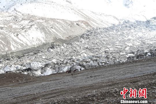
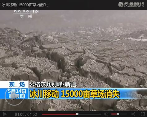
But a catastrophic collapse that generated a slide 20 km long and one kilometre wide is likely to be an ice – rock avalanche, or perhaps a more conventional landslide. IFENG has a more detailed report in Chinese, suggesting that the volume of the collapse might be 500 million cubic metres, and that the deposit is 20 – 50 m think. If so this is a truly enormous event. This report includes an image, but it is far from clear what this represents:
.
The IFENG report also includes a video, but again it is unclear what this is showing. It does include a sequence from which this still is taken:
.
This could be an ice-rock avalanche deposit perhaps?
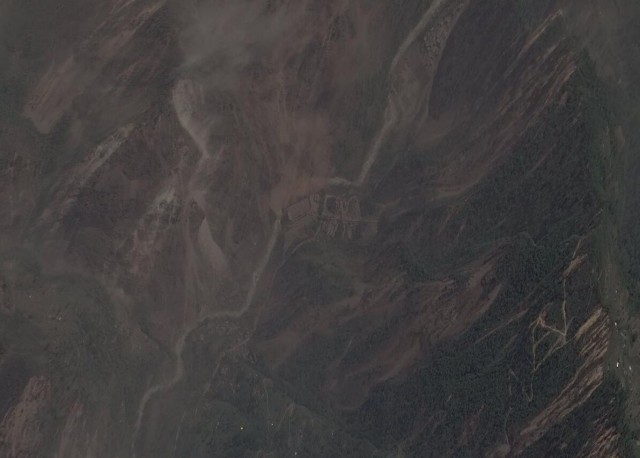
This is the Google Earth image of the area affected of Akto County by this landslide:-

Google Earth image of Kongar Tiube
.
This area is in the far northwest of China, near to the border with Tajikistan and Kyrgyzstan, so it is very unlikely that this event is associated with the Nepal earthquake sequence. Does anyone have any further information on this landslide? It appears to be a very unusual and interesting event.
16 May 2015
Landslides from the second Nepal earthquake
The second Nepal earthquake
The M=7.3 second Nepal earthquake on Tuesday released only about 13% of the energy of the first event. but the location and shallow depth meant that it still had the potential to generate landslides, albeit over a smaller area. The region affected by the second Nepal earthquake had already been affected by landslides triggered by the Gorkha earthquake, and this is one of the most landslide-prone regions of Nepal.
Digital Globe continues to release imagery of the earthquake-affected area on their online platform, for which we are extremely grateful. They have now collected some images of the areas affected by the second Nepal earthquake, most notably along the Araniko Highway, which is the main link between Nepal and Tibet. This image was collected on 13th May – a day after the second Nepal earthquake. The image quality is not great simply because there is so much dust in the air – and indeed the ground and buildings seem to be draped in a layer of dust, all generated by the landslides. But once you get your eye is you will see that there is massive landsliding across this area – indeed far more than was the case in the first earthquake:
Digital Globe
.
This is what the same area looked like before the earthquake (from Google Earth). It is almost unrecognisable:
Google Earth
.
The yellow markers are the larger landslides mapped by the Durham / BGS team after the Gorkha (25th April) earthquake. This is what the same area looked like after that event:
Digital Globe
.
The level of landsliding has clearly dramatically increased, and the road and associated infrastructure is very badly damaged. The landslides triggered in the second Nepal earthquake are characteristic of coseismic slides – they seem to be mostly shallow, disrupted rockslides, many of which originate from the ridge tops or other breaks of slope. The reasons why the second Nepal earthquake has generated so many landslides compared with the first event are not clear. This will need further study in the weeks ahead.
There can be little doubt that this area is going to be extremely difficult in heavy monsoon rainfall. The monsoon is a little more than a month away. In that context, the decision to refuse permission for the three Royal Air Force Chinook helicopters to operate in Nepal looks utterly absurd. Having witnessed first hand the amazing role that these helicopters played in the aftermath of the 2005 Kashmir earthquake, where the damage was so much worse, the refusal of the Nepal Government to allow these machines to operate is absolutely crass. In particular, the ability of these helicopter to carry large volumes of material in underslung loads was crucial in Pakistan. It is just crazy to stop that happening in Nepal.
12 May 2015
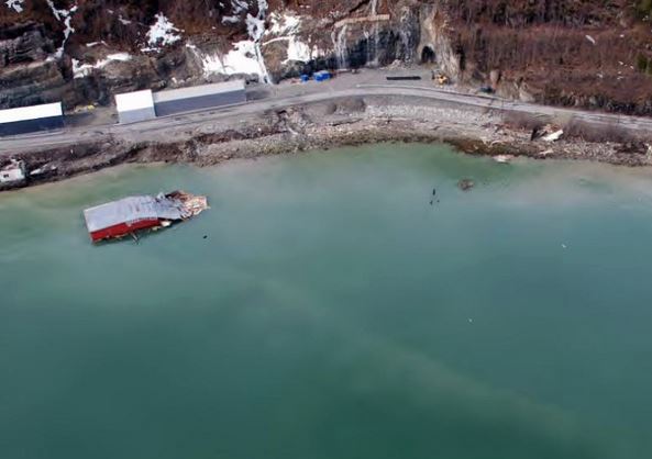
Sorkjosen (Sørkjosen) in Norway – an unusual underwater landslide
Sorkjosen (Sørkjosen) underwater landslide
Away from Nepal for a moment, a very interesting landslide occurred at the town of Sorkjosen (Sørkjosen) in Finnmark, Norway on Sunday. This appears to be the location as shown on Bing Maps:
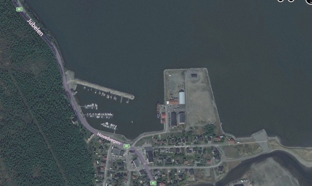
Sorkjosen (Sørkjosen) – Bing Maps
.
There is a good archive of images of the aftermath of the landslide on the NRK.no website (the article is in Norwegian):-
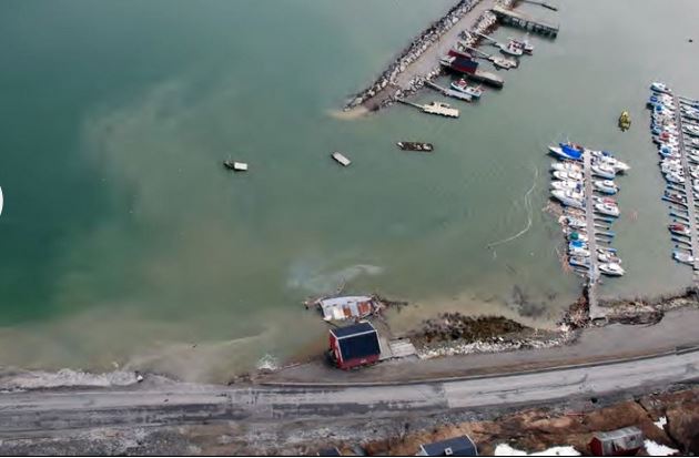
NRK.no
.
NRK.no
.
The landslide appears to have taken out an area of fill on the edge of the fjord and a large part of the jetty, plus some buildings, though fortunately no houses. If you compare the photographs with the Big Maps image the size of the Sorkjosen landslide becomes apparent. The timing of the landslide, in the early hours, meant that none of the buildings were occupied. The landslide has also effectively cut Norway in half as the highway through the town – the E6 road – has been closed. The diversion route is 700 km long via Finland (see this translation of the Norwegian article).
Interestingly, the images suggest that close to the crown of the landslide there was a large ongoing construction project on the highway, including the construction of a new tunnel (as seen in the image above). There is some speculation in the various articles that the landslide might have been associated in some ways with these works. Indeed, this article suggests that local fishermen have been concerned about this site for some time because of the dumping of spoil from the tunnel. The concern now will be to ensure that the landslide is not likely to retrogress and remove the road itself. In the longer term, it will be interesting to find out the causes of the landslide, and the mobility of the slipped mass.
This landslide is quite reminiscent of the Nord-Statland landslide, also on Norway in January of last year.
11 May 2015
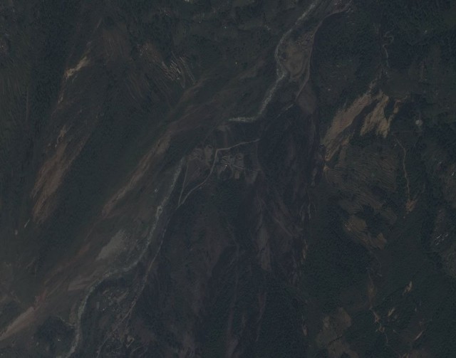
Jalbire, Sindhupalchok: the best landslide video from the Nepal earthquake to date?
Jalbire, Sindhupalchok landslide video
I think that this film, from Jalbire in Sindhupalchok, is the best landslide video to have emerged from the Nepal earthquake so far:
.
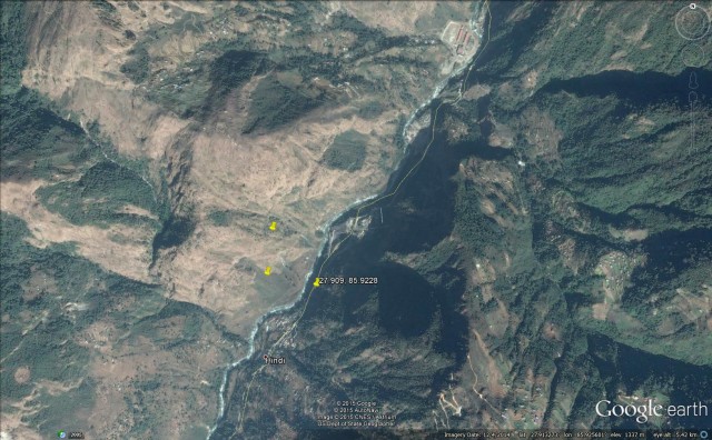
The location is Jalbire, which is a village in Sindhupalchok:
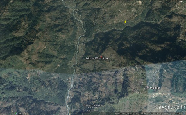
.
The yellow marker on the above image is a landslide mapped by the combined US / UK / Nepal team.
Gorkha earthquake update
Gorkha Earthquake update
The landslide situation in the aftermath of the Gorkha earthquake in Nepal is steadily becoming more clear due to the efforts of multiple parties. Importantly, the main groups working on mapping the landslides have now joined forces and are indeed generating a common dataset. There is a nice summary of their efforts on the ICIMOD Gorkha Earthquake portal, which notes that:
“To date, the response teams have identified over 3,000 landslides, and assembled a database of over 250 identified landslides and other large mass movements, focusing specifically on those that were generated by the earthquake and its aftershocks or other secondary effects.”
The Google Earth map of the 250 landslides is available to download as a kml file. The map looks like this:
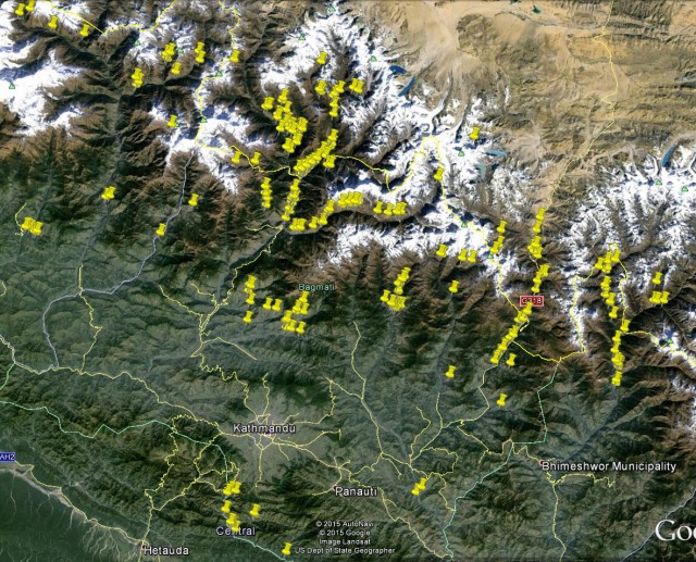
.
As the BGS / EWF team noted earlier, the landslides are concentrated in the northern area of the earthquake affected region, and many are along highways. Apart from the high losses associated with Langtang moraine and ice avalanche, the most serious landslide identified to date seems to be a valley-blocking slide on the Marshyangdi River upstream of Lower Pisang. NASA have a nice post describing this landslide, including this satellite image. This work was undertaken by Dan Shugar from the University of Victoria in Canada:
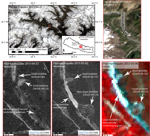
.
As of 6th May this landslide dam had not breached.
Meanwhile, news reports are describing the impact of landslides at various locations. For example eKantipur has an article outlining the loss of life from landslides in Rasuwa:
“Scores might be missing in landslides triggered by the devastating earthquake on April 25 at Mailung, which lies between Dandagaun and Haku VDCs in Rasuwa district. Rescuers have fished out 12 bodies from the debris as of Sunday. The Mailung settlement has been buried by landslides. Locals said around 250 workers at the 60 megawatt Upper Trishuli III A hydroelectricity project, access road of Upper Trishuli I and locals have been buried in landslides…However, the construction company has the record of 32 workers missing. Sixteen workers are from Rolpa, two each from Dang and Bardiya. The address of 12 others is yet to be verified.
Two bodies of workers engaged in constructing the Upper Trishuli I road track, have been found. Project chief Uttam Amatya said they had recovered the body of one Chinese and another Nepali whereas eight others are still unaccounted for.
The District Administration Office said one each from Nepal Army and Nepal Police were also killed in landslides. Police found six bodies of people who had reached Mailung for a picnic. Eight other picnickers are missing.”
The magnitude of landslide damage to new and under construction hydroelectric stations in Nepal is the subject of an article in the Himalayan Times, which details extensive landslide impacts at a number of sites.
Finally, to date 120 bodies have been recovered from the Langtang ice and moraine avalanche.
6 May 2015
Gorkha earthquake in Nepal: a landslide map and update on the landslide hazard
Gorkha earthquake in Nepal: update on landslide hazard
Vanessa Banks, Alex Densmore, Tom Dijkstra, Colm Jordan, David Milledge, Dave Petley, John Rees, Nick Rosser, Jack Williams
British Geological Survey, Durham University & University of East Anglia
This article was first posted to the EWF Blog yesterday
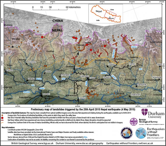
Key messages (all observations based on available cloud free satellite imagery)
- Major or disruptive landsliding is limited to a zone that runs east-west, approx. parallel to the transition between the Lesser and High Himalaya. This zone includes parts of the districts of Gorkha, Dhading, Nuwakot, Rasuwa, Sindhupalchok, Dolakha, Ramechhap, and Khavre.
- We observe several large valley-blocking landslides. Most observed landslides comprise comparatively small rockfalls and debris avalanches that have a significant local impact and loss of life.
- The need to plan measures to mitigate landslide deaths and disruption in the forthcoming monsoon season must remain a priority. Many more damaging landslides may occur in the 2015 monsoon, likely to start in late June, than would be expected if a major earthquake had not occurred.
Status
We were working to three objectives: identification of large landslides (1) blocking valleys and potentially causing significant secondary hazards; (2) affecting villages; and (3) disrupting infrastructure, such as roads. The team has undertaken a thorough investigation of available satellite imagery from multiple sources. The imagery has been investigated at 1:5,000 to 1:10,000 scales (with smallest features that can be distinguished ranging from about 5 to 15 m). Image resolution ranged from 2 m to more than 22 m. The team has obtained access to satellite imagery covering c.55,000 km2 with approximately 25% cloud-free. Analysis of imagery from the high Himalayas by the Charter Project Manager’s institution (NRSC-ISRO) has also been evaluated by the UK team.
We summarise some preliminary conclusions:
Siwalik and Lesser Himalayan regions
- We have high confidence that there are few major or disruptive landslides. Most landslides are small; many are re-activations of pre-existing failures whose locations will be known to local populations.
- Analysis of villages/infrastructure known to have been damaged by landslides shows that the latter are almost all small (> 10-50 m wide) and extremely difficult to identify using the available imagery.
High Himalayan region
- We have identified several large valley-blocking landslides (landslide dams) on the basis of satellite imagery (see Appendix 1). We stress that further valley-blocking landslides may still be found as additional imagery becomes available; other valleys in the High Himalayas should be assumed to be at risk until the existence of landslide dams can be confirmed or ruled out.
- A zone of relatively intense landsliding and disruption can be mapped in every valley for which cloud-free imagery is available, north and northeast of Kathmandu (red lines in the above map). This zone contains numerous rockfalls and debris avalanches, with many events following pre-existing pathways or channels and having long runout distances (in most cases, all the way to the valley floor). These events are individually localised but together are extremely widespread, and have had catastrophic impacts on roads and villages. It is these small, but widespread, landslides that are likely to have probably caused the largest loss of life due to landsliding.
- Cloud-free images are not yet available for all valleys within this zone; until they are, we must expect that similar levels of disruption are present in ALL valleys within the zone, not just those indicated in the accompanying map.
- Where visible, high-elevation areas (> 3,500 m) show evidence of some large rockslides, along with extensive avalanching (the latter especially above 4,500 m). Most of these areas are far from permanent settlements or infrastructure, and pose no direct threat to the population.
- Large areas of the High Himalaya, including valley floors and also most areas above 2,500 m, have not yet been examined because of cloud cover. We are continuing to monitor all possible sources of data.
Entire earthquake affected region
- The zone of intense landsliding corresponds to areas with high rates of seasonal rainfall-triggered landslides. We must thus expect that the risk due to continued landsliding in this area will escalate significantly as the rains begin. This continued landslide occurrence will threaten already-affected areas with continued failure, and will wash landslide sediment downstream onto valley floors and floodplains.
Landslides and major roads
The Arniko Highway (north to Tibet) is reported to be blocked from near Larcha to the Tibetan border by numerous rockfalls. This area has had chronic landslide problems prior to the earthquake, and the road is regularly impassable during the monsoon.
The Prithvi Highway (the main route from Kathmandu south to India) has also experienced ongoing landslide problems since the earthquake, including large rockfalls onto the road. This road has suffered extensive landsliding in the past. In August 2000 a single landslide blocked the road for 11 days, leading to severe shortage of fuel and other commodities in the metropolitan area.
Recommendations
- Before the onset of the monsoon, the potential valley-blocking landslides and valleys at risk discussed in the appendix should be inspected and monitored to assess the risk of landslide dam formation and further risk of failure during the monsoon. At present, there does not appear to be a high risk of imminent failure in any of the dams that may severely impact valleys downstream, but this may change as the monsoon develops.
- Road access to, and through, the zone of intense landsliding is going to be very challenging at least through the 2015 monsoon season. It would be sensible to undertake a survey of the major transportation corridors to identify where the problems are most likely to arise, and to prepare for the possibility of BOTH immediate action to clear rockfall debris AND continued clearance and maintenance of major roads after future landsliding.
- Collation of observations of the distribution, character and impact of landslides from people in the field is required to refine landslide hazard and risk assessments and validate the findings of the satellite-based survey we have undertaken. We have already instigated a social-media call to initiate this, but additional measures may be required, and a method of collation agreed.
- Users of post-event map products should be aware that several factors, unrelated to the actual distribution of landslides, may have influenced their apparent distribution: i) large areas of Nepal (such as most of those east of the map above) remain unsurveyed – largely because of cloud cover and image availability; ii) some other published maps are based on pre-earthquake landslide susceptibility evaluations rather than post-event observations; and iii) different methods have been utilised by respective agencies to map landslides; for instance, some do not appear to have taken full account of the occurrence of pre-existing landslides in their assessment of landsliding associated with the earthquake.
Appendix 1: List of confirmed or potential valley-blocking landslides
- Therapati, in the south of the Langtang National Park, in the Melamchi catchment. A landslide deposit has been identified on the edge of a high-resolution optical DG image (03/05/2015), and shows surface features characteristic of a rock avalanche (> 1M m3), which appears to toe-out across the valley base and likely causes a blockage. There is no evidence of a lake forming, but the valley at this time of year does not appear to have an active channel. The valley drains into the Trisuli River. If this interpretation is correct, this blockage may be a concern during melt / rainfall.
- Satellite images suggest multiple large valley blocking landslides in the main stem of the Trisuli, between Resuo (Nepal) and north to Jilong Community (Tibet). Some of these have already been identified by ICIMOD. This area presents concern.
- Video footage from the Upper Bhote Koshi suggests several reaches of rivers with abnormal standing water, notably immediately south of Chaku – most probably from extensive rockslides which appear to have removed extensive sections of the Arniko Highway, making this impassable. Flow downstream from these sites continues, so these blockages are unlikely to be high risk.
- Satellite images and news reports describe large post-seismic landslides in the 20 km north of Chaku to the Tibet – Nepal border at Kodari. Prior to the earthquake this road section had numerous deep-seated landslides in colluvium which tend to be highly active during the wet season. These sites pose significant risk of valley blocking should these landslides move. In addition, satellite imagery indicates extensive rockfalls and channelized failures on this stretch of road. Indications are that this area is still cut off. The Chinese army has cleared the road to Zhangmu (sometimes referred to as Zham) on the northern side of the border, but the communities of Larcha, Liping, Tatopani and Kodari appear still to remain isolated.
- Satellite images north of the Tibet – Nepal border at Nyalam show extensive areas of landsliding and avalanching. Rockslides have in places crossed the road and have reached the river, but none have generated lakes that are visible in the presently available imagery in the river network.
- Near Poki: a 1 km long rockslide (identified also by ICIMOD), appears to have blocked a valley, but has now been breached by the river. This area presents concern, but reports and imagery suggest that water is now flowing across this dam.
- Langtang: extensive landslides, rock avalanches and possible glacier snout collapses appear to have traversed the valley floor, and are likely to inhibit flow during melt. The situation in Langtang is well-documented elsewhere.
Note that the 2014 Sun Koshi landslide which cuts the Arniko Highway just upstream of the Bhote Kosi Hydropower plant, and the rock dam that it created, appear to be intact. The river and lake levels do not appear to have changed during the earthquake.
Appendix 2: Maps
High and low-resolution versions of the above map in both colour and black & white can be downloaded as PDF files from: ftp:\\topdog.dur.ac.uk\njr\nepal_eq
This article was first posted to the EWF Blog yesterday
 Dave Petley is the Vice-Chancellor of the University of Hull in the United Kingdom. His blog provides commentary and analysis of landslide events occurring worldwide, including the landslides themselves, latest research, and conferences and meetings.
Recent Comments