
22 June 2015
Landslide-induced sediment production after the Sabah earthquake in Malaysia
Landslide-induced sediment production after the Sabah earthquake in Malaysia
The Mw=6.0 5th June 2015 Sabah earthquake in Malaysia, which killed 18 people in rockfalls on Mount Kinabalu, generated landslides that have released large volumes of sediment. The heavy tropical rainfall in Sabah means that this sediment is now starting to enter the river systems in the form of mudflows and sediment-rich flash floods. So, for example, last week villages around the town of Ranau were struck by a series of mudflows. In particular, Mesilau was very badly affected, during a period of heavy rainfall last Monday. Mesilau lies on the flanks of Mount Kinabalu, but is some way from the main massif:
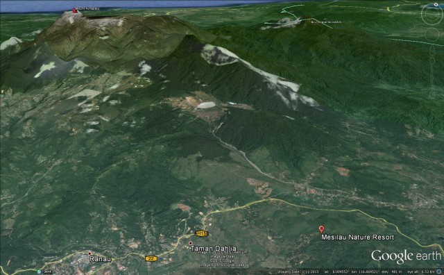
Google Earth
.
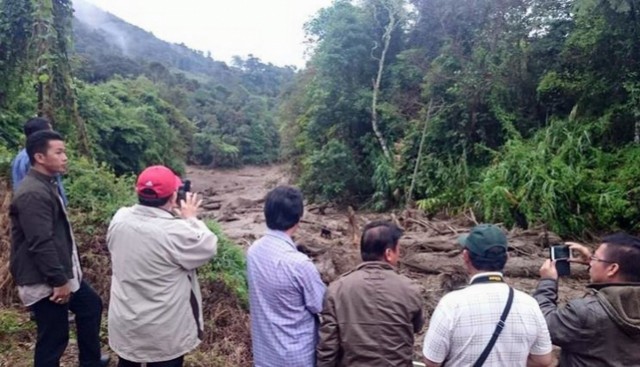
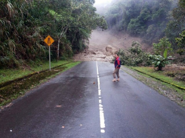
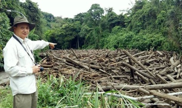
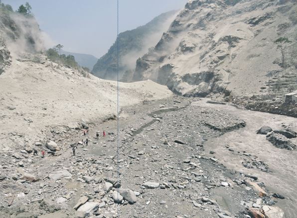
The AsiaOne website has an interesting gallery of images of the landslides that occurred last week:
.
.
.
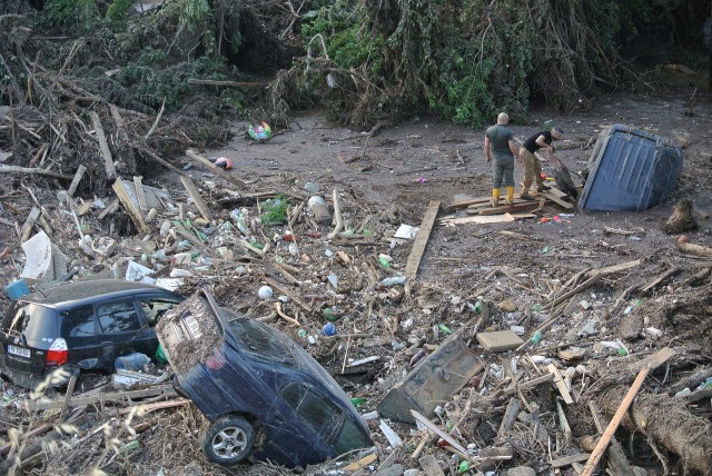
Notable here is the amount of timber in the river – to me this suggests that there must have been quite extensive landslides in the forested areas on the lower slopes of the mountain. I have not seen detailed reports or images of these landslides. The threat that this timber provides to the water supply and to the river itself is clear. The post-seismic landslides from the Sabah earthquake are also moving quite large volumes of sediment, including large boulders. Typically the riverbeds will aggrade (the bed level will rise as sediment is deposited), which will greatly increase the threat of flooding and damage to infrastructure. This slug of sediment will work its way down the river, extending the effects of the earthquake well outside the area affected by the high ground accelerations. In effect this will extend the effects of the earthquake in time and space.
The rainy season in Sabah starts in October, so this will be the main hazardous time. However, in the tropical environment of Sabah heavy rainfall can occur at any point in the year.
Fortunately Malaysia has an excellent slope management organisation, JKR, part of the Public Works Department.
21 June 2015
Tbilisi, Georgia:- a landslide dam-break flood killed 19 people
Tbilisi flood – 14th June 2015
A week ago, on Sunday 14th June, a flash flood ripped through a part of Tbilisi, the capital city of Georgia, causing a very significant amount of damage:
.
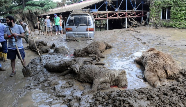
The floods are known to have killed 19 people and to have injured a further 457 people. Three people remain missing. The flood inundated Tbilisi Zoo, killing large numbers of animals and releasing many more:
.
Earlier this week it was reported that a tiger that escaped from the zoo killed a man before being shot. Another tiger was thought to be on the on the loose, but I am unsure as to whether it has been recaptured. News reports also suggest that one of the penguins in the zoo made a bid for freedom. In an effort that is somewhat reminiscent of a scene from The Great Escape it was finally recaptured 60 km downstream.
Understandably, the flood has been very controversial in Georgia. Whilst I am not really able to comment on the factors that underlie the event, it is clear that the flood itself was caused by the collapse of a landslide dam created on the Vere River near to the village of Akhaldaba. The Georgian Government has produced a video animation of the landslide and flood. Unfortunately due to a hosting problem associated with upgrading the software that hosts this site, I cannot embed videos at present. However, you can access it via the Youtube website. Although it is not in English, the sequence of events is clear, representing a classic cascading sequence of heavy rainfall, slope failure, valley-blockage, lake formation, dam collapse and catastrophic flood / debris flow.
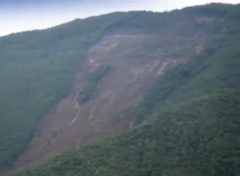
The landslide is estimated to have had a volume of about 1 million cubic metres. This still from the video above shows the slide:
 .
.
The landslide appears to be a shallow failure for the post part, possibly with a rotational component in the headscarp area. There appears to be a lot of water on the shear surface. Interestingly, Tbilisi also suffered devastating floods on a number of previous occasions, and the zoo has been destroyed by floods on the Vere River at least once before. It would be interesting to know if these earlier events were also due to landslide dams on the Vere River .
15 June 2015
Landslides in Art Part 22: Aberfan (7 pianos, percussion, voice and tools of rescue)
Aberfan: 7 pianos, percussion, voice and tools of rescue
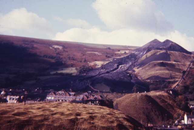
Laura Siersema is a composer and poet based in western Massachusetts in the USA. In the aftermath of the terrible 1966 Aberfan landslide disaster in Wales, in which 116 children and 28 adults were killed when a coal mine spoil heap collapsed and buried a school, her mother wrote a folk song “In a town called Aberfan”.
As we approach the 50th anniversary of the disaster next year, Laura has been working on anew, much longer piece about the disaster entitled Aberfan (7 pianos, percussion, voice and tools of rescue). In Laura’s words:
“My mother wrote a folk song, “In a Town Called Aberfan,” in the wake of the tragedy, that I used to hear when I was a child. I have been compelled for years to work on an adaptation of my own. Using excerpts of melody and lyric from my mother’s song, as well as portions of hymns sung earlier that morning and at the funeral one week later, Aberfan is now a full modern piece incorporating movements of Rain, Sunrise, Rubble, Rock, Hymns, Interludes, Trauma, Silence and a Field, and their alterations.”
This is a sponsored project of the New York Foundation for the Arts (NYFA). Two samples of the piece can be played online via Laura’s blog: First Hymn – Rock Sequence and Altered Rain. Laura also has posted some reflections on writing the piece on her blog.
Laura is seeking funding to record the full piece later in 2015, ahead of the anniversary of the Aberfan disaster next year. Details are on her website.
This is part 22 of the Landslides in Art series of posts on this blog. Part 21 is here.
8 June 2015
The Mount Kinabalu rockfall on Friday
The Mount Kinabalu rockfall
The Mount Kinabalu rockfall on Friday, triggered by a shallow M=6.0 earthquake, is thought to have killed 19 people. A significant number of them appear to have been children from Singapore on a school trip to climb the mountain. They were truly in the wrong place at the wrong time, a real tragedy.
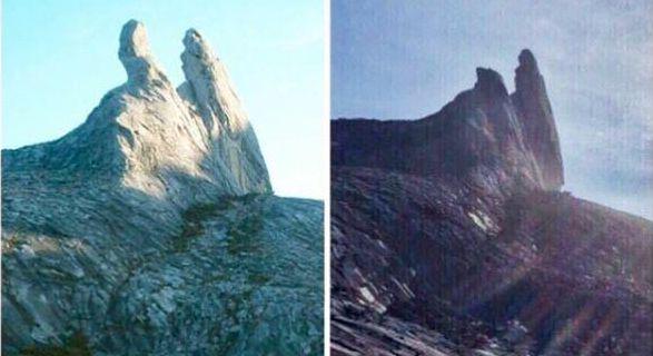
Whilst there appears to have been multiple landslides on the mountain, and indeed elsewhere, much of the loss seems to have come from the collapse of a rock pillar that formed one half of the “Donkey’s Ears” on the mountain. This is an image of this unusual rock formation before the earthquake:
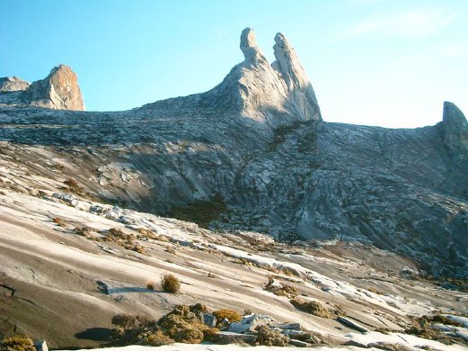
.
And this is how they look now (via Twitter):

.
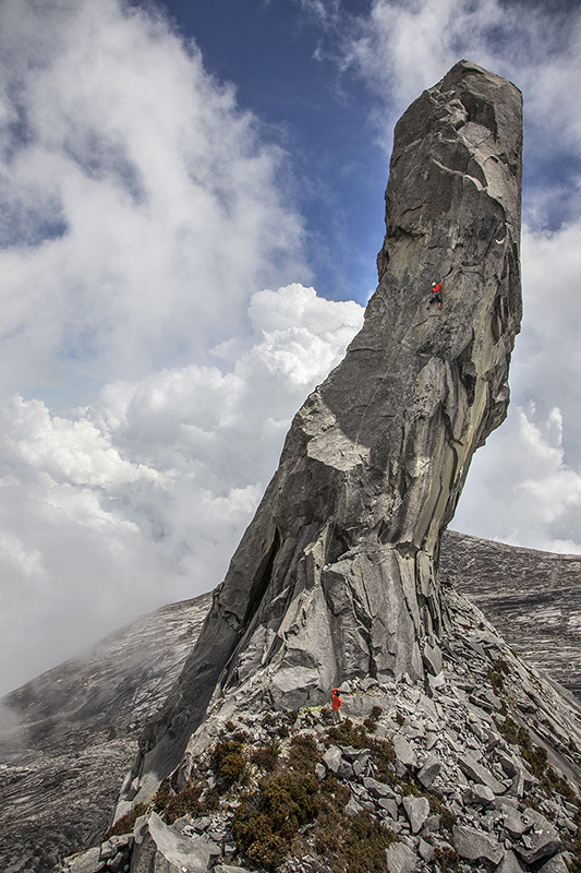
The column that collapsed is much larger than it might appear from the images. By coincidence, Planet Mountain ran an article late last week about new climbing routes on the Donkey’s Ears:
.
Interestingly, just below the climber in the image above there is a clear discontinuity inclined towards the right. About 20 m down there is another with a very similar inclination. I wonder if one of those was the detachment plane?
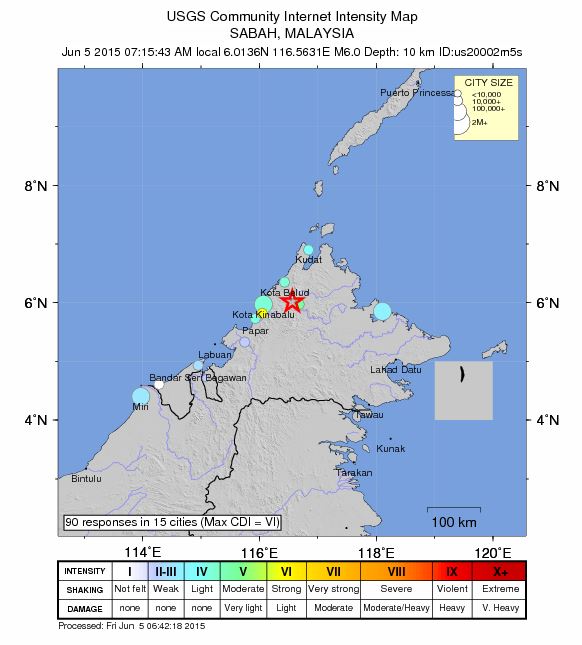
Whilst the image above shows that rockfalls on this column were far from uncommon (there is a huge amount of rockfall debris at the foot of the column, much of which is very large), this collapse event is very interesting. The column above would appear to be really vulnerable to the effects of seismic shaking, such that it is quite surprising that it has not collapsed previously. Does this indicate that the shaking associated with this seismic event was unusual in some way? The key is likely to be the very shallow nature of this earthquake, and its proximity to the mountain. This is the location, as given by the USGS, with Mount Kinabalu marked as well:

Google Earth
.
Such an earthquake could generate high Peak Ground Accelerations, but only over a very small area. These accelerations could have been amplified at the summit of the mountain. Thus. the key was probably the proximity of the earthquake event to the mountain and the shallow nature of the event. As such it may well prove to be an extraordinary but deeply tragic fluke.
5 June 2015
Malaysia earthquake: early reports of seismically-triggered landslides
Malaysia earthquake
Early on Friday morning (local time) a shallow (depth = 10 km) M=6.0 earthquake struck the west coast of Sabah in Malaysia:
.
Whilst not being large, this earthquake appears to have been responsible for at least some landslide activity. The clearest reports at the moment at from Mount Kinabalu, which is a popular trekking/climbing route. IBT Times is reporting that at least five climbers were killed close to the summit of the mountain:
The quake caused huge boulders and rocks to roll down the mountain as the climbers were descending at about 7.17 am, the report said.
Interestingly, The Star has an image that suggests that there has been a major rockfall at the summit of the mountain that has profoundly changed the geomorphology of the peak, known as the Donkey’s ears:
.
This would be a very substantive rockfall. There is also some early footage from the foot of the mountain that appears to show dust plumes created by the rockfalls:
.
Some early reports suggest landslides away from the mountain as well – this image possibly shows a lateral spread or fill slope failure; there are similar images from elsewhere on Twitter:
.
Hopefully more information will emerge in the coming hours. This earthquake should not have been responsible for large-scale loss of life, but there could be at least some infrastructure damage in a smallish area close to the epicentre.
3 June 2015
Pharkant, Burma: a liquefaction landslide in mine tailings (with a stunning video)
Pharkant, Burma: a liquefaction landslide in mine tailings
Pharkant is an important jade mining area in Burma. The mining is causing environmental destruction on an epic scale, and has been associated with large landslides on a number of previous occasions in recent years. The landslides appear to be primarily the result of poor mining practices, and in particular of inadequate management of the spoil generated by the mining activity.
Landslides in mine wastes are a major problem. In the UK the issue is best known because of the 1966 Aberfan landslide, in which the collapse of a spoil buried a school, with disastrous consequences. More recently, in 2013 a huge mine waste landslide in Tibet caused extensive loss of life. There are many, many other examples. One of the reasons for the terrible impact of these slides is the phenomenon known as liquefaction, in which apparently solid earth materials can transform into a very weak, fluid mass that can move both rapidly and over long distances. Under certain conditions some types of mine waste can undergo liquefaction, and very often it is the failure to manage (i.e. prevent) this process that causes catastrophic mine-related landslides.
Two videos have appeared on Youtube this week with no fanfare that illustrate this process to a degree that is unprecedented in my opinion. The videos apparently show a liquefaction landslide that occurred at Pharkant on 9th April 2015. The footage appears to have been shot from a mobile phone, and so it is understandably shaky. But I don’t think a mining-induced liquefaction landslide has ever been caught on camera like this. In terms of quality of the footage, the better video is the one that shows the second half of the landslide sequence:
.
.
The video starts as the first wave of debris spreads across the floor of the mine. Note the retrogressive nature of the landslide thereafter – material on the slope behind is going through progressive liquefaction and flowing down slope. The video is in effect capturing liquefaction in real-time.
Even better is the fact that the initial collapse event was also captured on video. Unfortunately, but understandably, the quality is much less good. In particular the video is rotated (is there a way of correcting this, does anyone know). But the footage captures the initial surge reaching the floor of the mine and sweeping up the machinery. The power and violence of the flow is terrifying:
.
.
The machines being swept up in the flow are not small by any means:
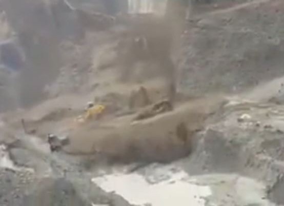
Pharkant liquefaction landslide via Youtube
2 June 2015
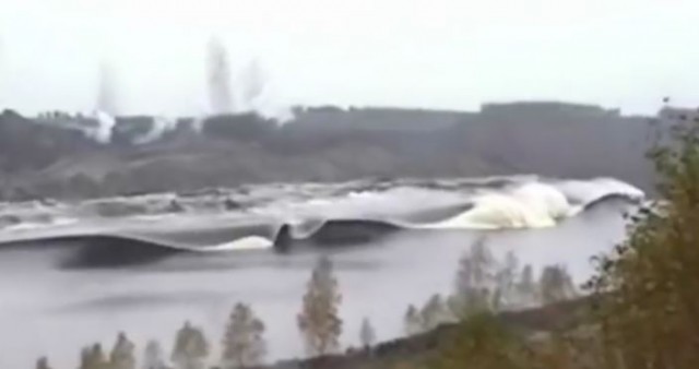
An amazing landslide tsunami video
Landslide tsunami video
I have absolutely no idea as to the setting or reason for this quite amazing landslide tsunami video:-
.
It is undoubtedly a controlled blast that has deliberately destabilised a very large section of slope. The effectiveness of the slide in generating the tsunami is clear, as is the complex nature of the water movement thereafter – see the image below. The speed and violence of this landslide tsunami is stunning.
28 May 2015
The 12th International Symposium on Landslides, Naples, June 2016
 The 12th International Symposium on Landslides (12 ISL) will be held on 12-19 June 2016 at the Royal Continental Hotel in Naples, Italy. This is a symposium jointly organized by FedIGS, ISSMGE, ISRM, IGS, JTC1. The previous symposia were as follows:
- 11th in 2012 in Banff, Canada (this is the meeting at which I gave the opening keynote lecture)
- 10th in 2008 in Xi’an China;
- 9th in 2004 in Rio de Janeiro in Brasil
The deadline to submit abstracts is 30th June 2015.
The organisers of the meeting have selected “Experience, Theory, Practice” as the key theme.
The symposium will focus on the following main session themes:
- Weather-induced landslides
- Earthquake-induced landslides
- Volcanic activity and landslides
- Man-induced (I assume that this means human-induced!) landslides
The Scientific Committee is encouraging authors to submit abstracts dealing with one or more of the following topics:
- Soil and rock properties
- Investigation and slope monitoring
- Mechanisms and mechanical aspects
- Analysis and modeling
- Risk analysis, assessment and management
- Control works
My view is that the International Symposium on Landslides remains the most important landslide meeting in the calendar. I have attended the last two, both of which have been both scientifically fascinating and hugely enjoyable. I strongly recommend it!
27 May 2015
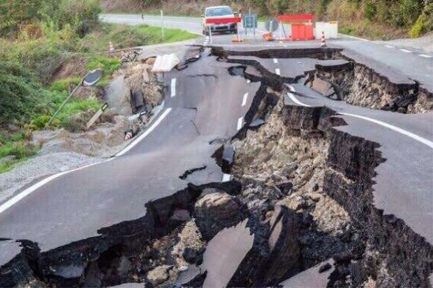
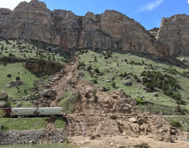
Wind River Canyon in Wyoming: US20 closed by rockslides and debris flows
Wind River Canyon in Wyoming
Unusually heavy rainfall in Wyoming on Sunday triggered a series of landslides that has led to the closure, probably until Wednesday, of the US20 highway between Thermopolis and Shoshoni as well as the BNSF railway line.
The best coverage of the event is on the County 10 website, which has a splendid gallery of images of the landslides. This image for example is both beautiful and technically interesting:
.
These are not simple landslides by any means. In all three cases they involves water that has been channelised on the steep slopes, from where it has collected debris, and which has triggered the detachment of boulders from the bluffs. The flows have transitioned into true debris flows on the fan below the bluffs. Note that in most cases the flows have eroded sediment from the fan in the steeper portion, adding to their volume. At the point at which the gradient of the slope reduces, just above the railway line, the flows have stopped eroding and have started to deposit, with the larger boulders being left higher on the slope and finer material further down. This is classic debris flow behaviour.
Other failures show slightly different behaviour. This one for example appears to have been erosive all the way to the river, probably because these was no reduction in slope gradient all the way down to the floor of Wind River Canyon:-
.
Google Earth gives a better understanding of the nature of these landslides. In fact above the bluffs each of these gulleys has quite a large catchment of more erodible material:
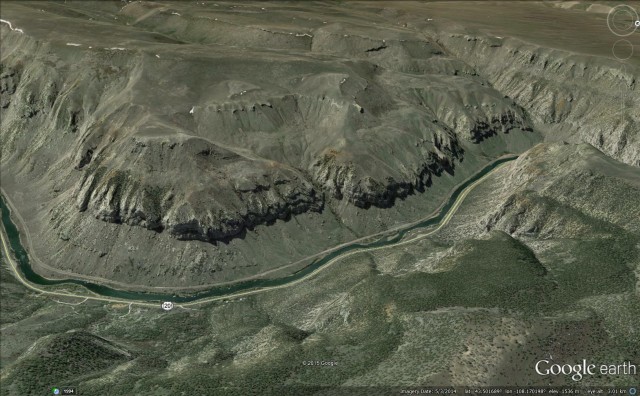
Wind River Canyon from Google Earth
.
These upper catchments are likely to be the source of much of the sediment that forms the debris fans at the slope toe and that comprises the solid part of the debris flows.
26 May 2015
Kali Gandaki: an interesting landslide dam and breach
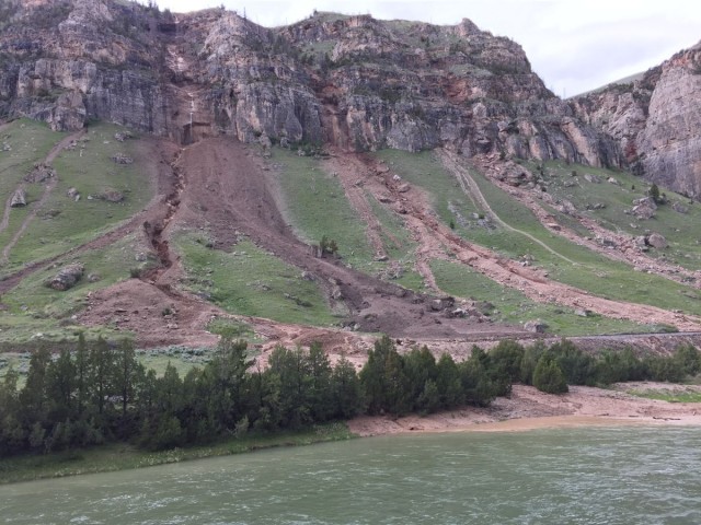
Kali Gandaki: an interesting landslide dam and breach
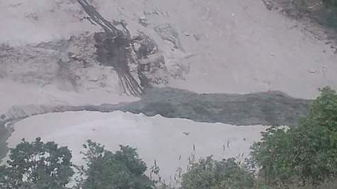
Early on Sunday a landslide occurred at Ranche in Myagdi District of Nepal, blocking the large Kali Gandaki river. The area affected by the landslide was affected by the earthquake of exactly a month ago, but interestingly there appears to have been no trigger. In this case the response of the authorities appears to have been exemplary, with downstream settlements, most notably the town of Beni, being evacuated and an assessment team being flown by helicopter to the site. The dam breached about 15 hours later, releasing a significant flood that caused damage but no loss of life.
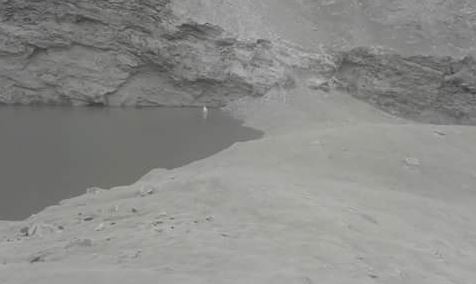
The best source of information throughout was the twitter account of @gocoolchhetri, even though it is in Nepali (and Google translate does not do a good job on Nepali to English). But from the start he tweeted a series of photographs of the blockage on the Kali Gandaki, including this one of the landslide dam itself:
.
Note the large amounts of dust from ongoing landslide activity. This one showed the lake as it filled:
.
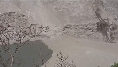
This one showed the top pf the landslide dam as the water level rose. Note the fine grained material mantling the top of the blockage:
.
And the dam from above:
.
And then the overtopping initiating:
.
And then developing rapidly:
.
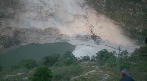
Ekantipur has an article today on the aftermath of the landslide, which states that:
A 2km long and 100 metre deep lake was formed after the landslide dammed the river. The site is about 9km north of Beni, the district headquarters of Myagdi. Massive rocks started falling past Saturday midnight, damaging 27 houses in Bhagawati and Ramche VDCs. Bhimsen KC, a local of the landslide-buried Baisari, said the dam is about 40 metres high from the riverbed. He believes there is no possibility of an outburst of the lake as the dam is about 100 metres wide.
And it includes this image of the aftermath of the landslide that blocked the Kali Gandaki:
.
This interesting event serves once again to highlight the challenges that face Nepal in the months ahead.
 Dave Petley is the Vice-Chancellor of the University of Hull in the United Kingdom. His blog provides commentary and analysis of landslide events occurring worldwide, including the landslides themselves, latest research, and conferences and meetings.
Recent Comments