
26 October 2016
Leaving the University of East Anglia
Leaving the University of East Anglia
Today is the my last working day at the University of East Anglia (UEA). I have the removal company coming in tomorrow, and by the end of the day, all being well, I’ll be in a hotel in Sheffield. I start my new post as Pro-Vice-Chancellor at the University of Sheffield and Professor in the Department of Geography on Tuesday.
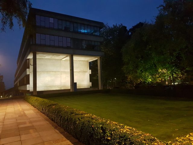
The University of East Anglia this morning
.
Here at the University of East Anglia I have been Pro-Vice-Chancellor (Research and Enterprise), a role that I have loved. UEA is a comparatively young university, but one that is immensely popular with students and that embeds a can-do attitude to research. In the latter it is most famous for Climate Change (UEA maintains the crucial HAD-CRUT4 temperature dataset) and creative writing, but there is also great strength across the disciplines from neurological physiotherapy to the Magna Carta, dementia to competition policy, international development to leafcutter ants, and much more besides. It has been a fascinating journey.
Inevitably, there have been frustrations, and as with all posts I leave pleased with the progress that we’ve made but with a sense that I could have achieved more; that is inevitable. But it has been a great pleasure to work with the rest of the senior management team, especially the Executive Deans and their Associate Deans, and I would like to single out Helen Lewis, the Director of the Research and Enterprise Division, for the extraordinary support she and her section have provided. Helen is a phenomenon, and I hope that the University continues to appreciate her talent and dedication. I could not have done my job without her.
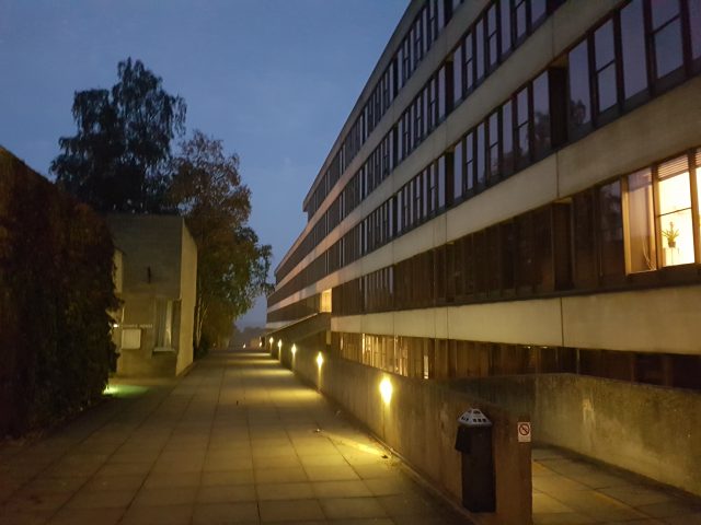
The iconic Teaching Wall, designed by Denys Lasdun, at the University of East Anglia
.
And of course my role needed the fantastic support provided the administrative team in the Vice-Chancellors Office, and I would especially like to single out my (now retired) wonderful PA, Jacqui Churchill.
My place is being taken by Professor Fiona Lettice for the next nine months. Fiona will do a fantastic job, and I wish her well.
Overall I have learnt so much, and I have enjoyed every minute of the role. Norwich is a wonderful city and the University of East Anglia is a great institution that is going places. At the end of the day universities are about people, and UEA has many wonderful people at all levels.
25 October 2016
Structures in the Aru Mountains giant avalanche deposits
Structures in the Aru Mountains avalanche deposits
The second enormous Aru Mountains avalanche in Tibet that I featured yesterday have been imaged by an innovative start-up satellite imagery company called Planet, which is launching a constellation of satellites that it is building itself. The quality of the image of the second Aru Mountain avalanche is fantastic, good enough to draw out some very interesting features:-
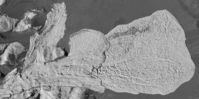
The second Aru Mountains avalanche, imaged by Planet
.
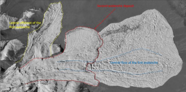
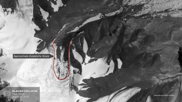
The first key element, that I mentioned yesterday is that it appears to me that this is two separate events, with the deposits lying on top of each other. In the image below I have drawn the boundary between the two. The first event appears to have been larger and to have traveled further:
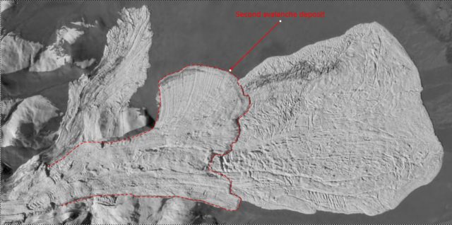
Annotated map of the Aru Mountain avalanche deposit, imaged by Planet
.
The second deposit very clearly lies above the first. The larger, initial, avalanche appears to have had a large lateral offshoot that traveled surprisingly far:
Annotated image of the second Aru Mountains avalanche, imaged by Planet
.
At first glance this looks quite illogical as the Planet image from before the avalanche (below) shows that it has crossed a line of elevated ground. However, this offshoot is almost dead in line with original orientation of the glacier. The implication is that the movement was so rapid that it a portion ploughed straight ahead, over the topography. The second avalanche followed the topography, which suggest to me that it was less energetic. The main deposit from the first avalanche has a very nice central flow structure that I have highlighted above as well; this is even visible beneath the second flow.
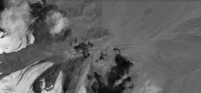
The “before” image of the second Aru Mountains avalanche, imaged by Planet. The glacier that collapsed can be seen bottom left. The avalanche initially flowed over the topography in line with the glacier. The later part of the first collapse, and the second one, followed the topography into the main valley
.
The dynamics of the flow are very complex, but a key factor is the basal friction. The role that this plays is beautifully illustrated by two elements of the second avalanche that I have highlighted below.
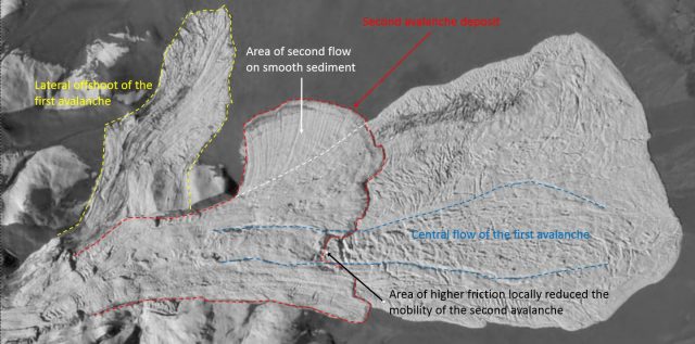
Annotated image of the second Aru Mountains avalanche, as imaged by Planet
.
The initial avalanche event flowed over glacial sediment, whilst the second phase flowed mostly over the deposit from the initial event. Thus the basal dynamics, and friction, were very different. I have annotated in black the portion where the second flow was traveling over the Central Flow structure (in blue). This must have been a rougher surface, with more friction, as the second flow has suffered reduced mobility in this area and has traveled less far, as evidenced by a cut out in the boundary of the flow. and in the north of the image the second flow has spilled over onto fresh sediment (annotated in white). The different basal regime is reflected in a very different deposit, with clear flow lines that are not visible elsewhere.
Thus, the quality of this satellite image allows detailed analysis of this giant avalanche, providing insight into the event. Of course with proper mapping and analysis it would be possible to provide a great deal more understanding.
Other posts that may be of interest
- The mysterious Tibetan ice avalanches of summer 2016
- Lamplugh Glacier rock avalanche: A massive new landslide in Alaska on Tuesday
- Sitka landslide in Alaska – the potential power of simple geomorphic mapping
- Review of a paper: The Donghekou landslide in China
- Oso landslide: differences of opinion about the landslide mechanisms
- Mount La Perouse landslide: a Landsat 8 satellite image
- Jupille 1961: an extraordinary fly ash landslide
- New high resolution images of Kedarnath – the cause of the debris flow disaster is now clear
24 October 2016
The mysterious Tibetan ice avalanches of summer 2016
The mysterious Tibet avalanches of summer 2016
At the start of the summer, a somewhat mysterious giant ice avalanche occurred in the Aru mountains above Lake Aru Co, the first of a pair of Tibet avalanches in this region. This was covered by Xinhua, with a strong sense of surprise.
The avalanche in southwest China’s Tibet Autonomous Region on Sunday was a glacier slide, it has been confirmed. A 600-meter rescue passage had been completed Wednesday morning, but no signs of life have been detected. Nine people, buried by the icefall in Dungru Village in Rutog County, Ngari Prefecture, on Sunday, were confirmed dead on Monday. … “Rescue work is continuing, while the cause of the ice avalanche is being investigated to avoid secondary disasters”, said Zhang Jianping, a police officer directing the rescue. UAV aerial images show that the icefall took place between glaciers on two snow-capped mountains at an altitude above 6,000 meters.
CriEnglish included some images of the avalanche:
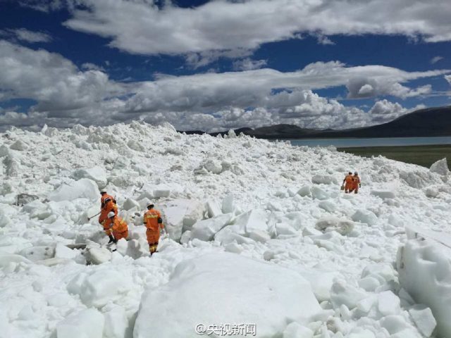
One of the Tibet avalanches, via Cri-English
.
It is hard to fathom this size of this event, but satellite images help. The European Space Agency imaged it with the EOI instrument, generating this before and after pair of shots (via NASA):
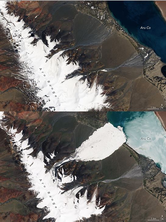
The first of the Tibet avalanches, imaged by the EOI instrument (via NASA)
.
This is a very large event – estimated at 60 million cubic metres and with a deposit that covers some 10 square kilometres. Few such events have been previously described, so their mechanisms are poorly understood. The Atlantic has a really nice article about this event, highlighting the work of Andrea Kaab at the University of Oslo, who has been investigating it. This includes a nice image of the source area, captured by Planet:
The source area of the first of the Tibet avalanches, via Andreas Kaab and The Atlantic. Image collected by Planet
.
But there is another really surprising aspect of this event, as The Atlantic describes:
This Planet imagery revealed new aspects of the Tibetan glacier. Before the Aru glacier failed, it looked like it was about to surge. Water pooled on its surface, and crevasses started to appear. Surging, though, is a regular part of a glacier’s life. Why had the Tibetan glacier failed catastrophically and not started surging like it should have?
For now, this question will require further study. More worrying was a feature that Kääb noticed in a Sentinel-2 image, something to the south of the avalanche’s debris field. Another glacier had started exhibiting the same characteristics as the Tibetan glacier which collapsed. It showed large crevasses. Would it collapse as well?
This second glacier collapsed on 21st September, generating another enormous avalanche deposit. Planet has a high resolution image of this second event; the edge of the remains of the first deposit are just visible at the top of the image:
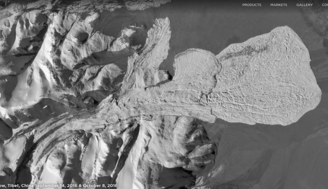
The second of the Tibet avalanches, image by Planet
.
The one such event should occur is remarkable; two is unprecedented. In fact the second avalanche look to me to be two separate events, the larger of which occurred first, based on the apparent presence of two deposits in the above image.
The most likely explanation for the Tibet avalanches, and the associated glacial collapse, is climate change. That Tibet is warming rapidly, and that the glaciers are retreating rapidly in response, is well-established. This style of extreme mass movement appears to be a rather dramatic, and worrying, response.
Previous posts that might be of interest
- More information on the disastrous mining-induced landslide in Tibet a fortnight ago
- So was the Tibet landslide, which killed 83 people, really “natural”? You be the judge
- The first anniversary of the Gorkha earthquake in Nepal: the Langtang rock and ice avalanche
- Reports of a massive ice – rock avalanche in Akto County, Xinjiang, China?
- The Siachen Glacier avalanche (138 people killed) was an ice-rock avalanche
- The physics of snow and ice – two videos
- A new mechanism for landslide initiation
Acknowledgement
Thanks to Dustin Rainey for pointing this one out to me.
21 October 2016
The Aberfan victims and survivors
The Aberfan victims and survivors
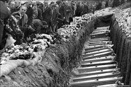
Today is the 50th anniversary of Aberfan, an event that will be commemorated both at the site and across the United Kingdom. It is of course a day to remember the Aberfan victims, the majority of whom were children and teachers at the Pantglas Junior School, and to hear accounts of the survivors. Those lost are remembered in a simple memorial garden at Aberfan, with two ranks of graves for the victims:
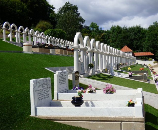
The memorial to the Aberfan victims
.
Of course there were survivors of the disaster too, and various media outlets this week have featured accounts of the day from their perspective. Perhaps the most powerful is an account in the Guardian yesterday, which has printed a letter that a young journalist, Alix Palmer of the Daily Express wrote to her mother having been dispatched to the site. The letter is worth reading in full, but this excerpt is very powerful:
Looking down on that terrible mess of a school from behind on the mountain side with a blanket of slag on it, nothing of the inside of the building could be seen.
Wherever you looked, women stood waiting. You could tell which were the mothers; they weren’t crying, just huddling together. The fathers straight from the pit were digging. No-one had yet really given up hope, although logic told them it was useless.
Every now and again the organiser of the operation would yell through a loud hailer for quiet. That was the most terrible moment of all. Someone had seen an arm or a leg and everyone longed for the sound of a child crying.
The gigantic bulldozer, operating in such confined spaces and with such deafening noise, would stop. The noise of spade against spade and the murmur of orders would cease, the women would draw a little nearer and everyone would hope.
Then a body would be brought out gently, cleared quickly of a casing of slag which clung to the skin and clothing. A doctor would push his way through and everyone waited. Then the doctor would wrap the little body gently in a blanket and it would be carried into the building of corrugated iron which served as a mortuary.
This went on for hours… All through the night we worked, talking to people or trying to, because how can you talk reasonably to mothers who have just identified a dead child?…
At eight o’clock, I went to the school in the next village where the parents were meeting the chief constable. They were asked to fill in forms, listing the children who had been at school that day which was the only way of checking because class registers were still buried. And as the mothers sat down to write the names of their children, the tears came.
I need say no more.
20 October 2016
The Aberfan tragedy – what happened next?
The dreadful reality of the Aberfan tragedy (via Getty Images)
The Aberfan tragedy – what happened next?
The National Coal Board and the tribunal
In the stunned aftermath of the Aberfan tragedy, a sense prevailed that there must never be a repeat. The Official Tribunal worked efficiently, and the final report pulls no punches about individual and corporate responsibility, even if this did not translate into criminal prosecutions. As I have noted previously, a remarkable aspect of the Tribunal is the belligerence of the National Coal Board – even more remarkable for the fact that it was a government body – to the extent that the Tribunal report includes a section entitled “The attitude of the National Coal Board“. The section on liability starts with the following observation:
Blameworthiness for the disaster of 1966 remained an issue strongly contested by the National Coal Board for the greater part of the Tribunal’s sittings
This is indeed the case, although ultimately they did concede responsibility, and the Tribunal report does not hide its distaste for the way that the National Coal Board conducted themselves. Given the facts of the case, as I have outlined in my previous two posts, how could the National Coal Board have argued that they were not to blame?
At the start of the Tribunal, the National Coal Board claimed that:
“The Board’s view is that the disaster was due to a coincidence of a set of geological factors, each of which in itself is not exceptional but which collectively created a particularly critical geological environment.”
The Tribunal report notes that:
The Tribunal is in no doubt that this was the starting-point of an attempt, persisted in for many weeks by the National Coal Board, to persuade acceptance of the view that the concatenation of geological features on Merthyr Mountain was such as could not reasonably have been expected to exist. The observation quoted at first sounded impressive, but it turned out that it explained nothing.

Lord Robens, painted by Jane Allison
.
The Tribunal is particularly critical, and rightly so, of Lord Robens, the Chairman of the National Coal Board, who gave evidence to the Tribunal investigation the Aberfan tragedy. The report notes that within two days of the disaster Lord Robens had made the following comment to a television reporter:
“It was impossible to know that there was a spring in the heart of this tip which was turning the centre of the mountain into sludge”.
This was of course clearly not the case – the Ordnance Survey maps clearly showed these springs. Despite this, the Tribunal notes that this remained the position of the National Coal Board until Day 65, and even then they only changed their position under cross-examination. Late in the day, the Tribunal decided to give Lord Robens the opportunity to give evidence. Remarkably, he initially maintained his position that the hazard could not have been known, and thus that the Aberfan tragedy could not have been anticipated:
I think it would have been apparent to anybody that what I was saying is that the people on the site did not know, and it would have been impossible for them to know, because we had failed as a Board to provide the necessary regulation [sic] to enable them to know…
The criticism of this position by the Tribunal is scathing:
That this interpretation was placed on his words by no other National Coal Board witness who was asked to deal with them and, furthermore, had not occurred even to learned counsel appearing for the National Coal Board, emerged clearly in the course of the Inquiry. Nor did we accept it for one moment. Ultimately, even counsel for the National Coal Board invited the Tribunal to ignore it. By his words, read in their entirety, Lord Robens had conveyed to no-one that he was accepting that any measure of blame lay with the National Coal Board.
Hidden in this statement is a remarkable observation:
Ultimately, even counsel for the National Coal Board invited the Tribunal to ignore it.
Thus, even the lawyers for the National Coal Board directed the Tribunal to consider Lord Robens to be an unreliable witness. The Tribunal also noted that during his cross-examination, Lord Robens eventually conceded that the National Coal Board had determined that the instability was foreseeable, even before the Tribunal itself began. The report notes:
If the position really was as Lord Robens said (viz, that before ever the Inquiry opened the National Coal Board realised that the instability of Tip 7 was reasonably detectable before the disaster) it followed that a vast amount of time had been unnecessarily spent on issues which were directed at establishing that very point.
Recommendations of the Tribunal
The Tribunal made a number of recommendations. The first concerned the site itself – the Tribunal of course recommended that the site be made safe, but noted the objections by the National Coal Board to the ideal solution, removal of the tips altogether. Thus, the Tribunal recommended recontouring and drainage. I return to this below.
The Tribunal also made clear recommendations about the assessment of sites to be used for tipping, and about management of the tips themselves, primarily through a National Tip Safety Committee, with properly qualified experts. The Tribunal notes the importance of proper governance, responsibility and accountability. This was enshrined in law in 1969. That there has been no repeat of Aberfan in the UK suggests that these recommendations were effective.
The scandal of the unquestionably unlawful extraction of money from the Disaster Fund to pay for the removal of the tips
In the aftermath of the Aberfan tragedy, the public donated £1,606,000 in almost 90,000 individual contributions to a Disaster Fund. In 1966 this was a vast sum of money (wikipedia estimates that this is £27.8 million by 2015 values). After the disaster, a decision was taken to remove the tips above Aberfan, although the National Coal Board maintained a view that as they were not dangerous they had no responsibility for the costs of this operation. Under “intolerable pressure” from the Labour government, but in secret, the trustees of the Disaster Fund agreed to provide £150,000 to pay for the removal. This deed did not become fully clear until 1997; subsequently the regulator of charities in the UK, the Charities Commission, have ruled that this was “unquestionably unlawful”.
In 1997, the Labour Government of Tony Blair repaid the £150,000 to the Disaster Fund, but without any interest. Whilst this in some ways repairs some of the damage, that interest was not paid means that the Disaster Fund made, in effect, an interest-free long term loan to the National Coal Board. This remains deeply unjust.
19 October 2016
Aberfan: The National Coal Board failures part 2
Aberfan: The National Coal Board failures part 2
Yesterday I described how the National Coal Board failed to recognise, or just ignored, the risks posed by spoil heaps, despite multiple previous failures. Some of these occurred at Aberfan itself. But this was not the only failure by the National Coal Board in the period leading up to the collapse. The Official Tribunal was also scathing about the siting of the spoil heaps at Aberfan:
With the enduring reminder of the 1944 slide so clearly visible and its causes still remaining unknown, no fresh tipping on the mountainside should have been begun without a complete survey, without boreholes, without proper drainage, and without indicating the limits of the tipping area. And even without a survey, reference to the available geological map would have revealed a line of springs at the Brithdir seam, the Ordnance Survey would have given warning of watercourses, and the site would thus have been revealed as obviously unsuitable for tipping beyond a short distance from the rail incline. Indeed, even without referring to a single map, we are satisfied that there were features clearly to be seen which should have brought home to Mr. R. N. Lewis (Colliery Manager) and Mr. Joseph Baker (Group Mechanical Engineer) how limited was the area of suitable tipping land there available to them.
So why did the Tribunal determine that the site was so unsuitable for the siting of a spoil heap? This lies at the heart of the collapse.
Britain is an exceptionally well-mapped country, such that both the mine planners and the Tribunal has access to very high quality, unbiased maps of the terrain prior to the construction of the tips. The Tribunal report included one of these maps in their analysis:
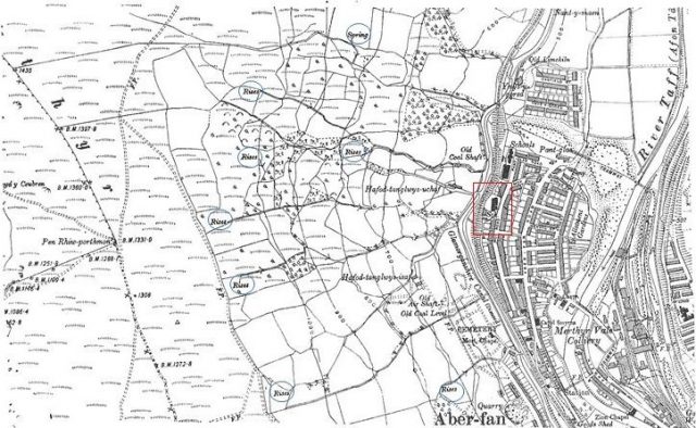
Annotated topographic map of the Aberfan site before the spoil heap was created, showing the springs (“rises”) that mantled the slope, from the Official Tribunal
.
The location of Pantglas Junior School is in red, and I have circled the multiple springs (labelled as “rises”) across the slope. Note the streams that flow down into the valley from these springs. The investigations were led by Professor A.W. Bishop of Imperial College, an authority in soil mechanics and slope behaviour. The Tribunal notes that Professor Bishop highlighted that this water contributed to the landslide in four ways:
I. Water issuing beneath the tip has caused back-sapping [this is erosion on the downslope face of the tip] and led to recurrent movements over the years since 1963.
II. Water under pressure acting in the tip material and in the limited area of the foundation where the slip surface was adjacent to the natural ground reduced the effective stresses in the fill and initiated a shear displacement. In view of the presence of pre-existing slip surface, this pressure need not have been very large.
III. Water filling (or nearly filling) the voids of the loose fill comprising the tip and covering the area of mountainside below it made it susceptible to a catastrophic flow slide, since a shear displacement or shock wave could result in the transfer of most of the load on to the relatively incompressible water in the voids, thus reducing the frictional strength to a very low value.
IV. Water released by the slip and consequent flow slide caused a ‘mud run’ of tip rubbish.”
The key mechanism is the second if course, in which the rising water level decreased the resistance to shear, allowing the slope to fail. The construction of the tips on top of the springs and their associated streams, without any means for the water to be managed, inevitably meant that water would collect in the spoil heaps. This was utter folly.
The point about pre-existing shear surface is critical – Bishop found that Tip Number 7 had been built upon waste from earlier failures, and of course had previously slipped. This meant that the materials were weaker than when freshly tipped, and so more likely to slip. But the slope was also mantled with a layer of glacial till, commonly known as boulder clay in the UK, upon which the tip had been constructed. This boulder clay may have provided an additional weak layer that allowed the tip to deform (it did not form the shear surface of the landslide itself), and it may also have prevented drainage of the water that was ponding in the tip. Finally, the role of the springs may have been exacerbated by mining disturbance, which had opened up new pathways for water to flow from the slope, probably nearer to the valley floor, and thus increased the ponding of water in the slope.
Thus, the Tribunal was clear about the failures by the National Coal Board. They highlight that it is obvious that construction of a tip on a pre-existing slope requires additional consideration, and in particular detailed site investigation. The Tribunal is clear that the National Coal Board did not undertake adequate site investigation, did not prepare the site correctly, did not plan the expansion of the tips (particularly with respect to allowing a new tip to be built on the deposit of a previous failure), and did not manage the tips in a responsible manner.
In the modern context, a basic requirement would be to undertake proper site investigation, to remove weak materials from the land surface before tipping begins, to build culverts to allow the springs to flow, to actively drain the water from the waste, to plan the tips and to monitor their stability. This has prevented repetition of this disaster in most developed countries, but as I point out in my New Civil Engineer article, water-induced failures of mine waste are still far too common in some places.
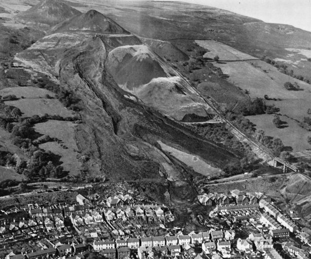
The impacts of the failures by the National Coal Board are all to clear in the image below of the failure, which I have annotated to show the main features:
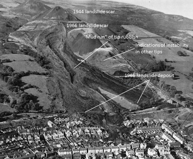
Annotated aerial photograph of the Aberfan flowslide, via the Official Tribunal
.
50 years on it is hard not to be horrified by the multiple failures of management that led to this catastrophe.
18 October 2016
Aberfan: the National Coal Board failures part 1
Aberfan: the National Coal Board failures
As I noted in my post yesterday about the Aberfan disaster, the official Tribunal roundly criticised the National Coal Board for the part that they played in the disaster. Indeed, having denied responsibility through much the of the hearing, late in the day the counsel for the Board accepted the blame. As the Tribunal states in its report:
But, as witness followed witness, the answer to the question — Should anyone be blamed for the disaster? — became crystal clear as far as concerned the National Coal Board. It was finally enunciated in this way on Day 74 during the closing speech of counsel for the Board: “Need it have happened? . . . There is a very short answer to that one. It need not have happened and should not have happened if proper site investigations had been carried out beforehand. The failure to have any site investigations beforehand must be attributed to lack of instructions from the Coal Board.”
Before the disaster (and indeed afterwards as well) there were multiple failures by the National Coal Board, but I will focus on two key aspects – the history of spoil heap flowslides in South Wales (which I will describe today) and the failure to understand the site conditions at Aberfan (which will be the subject of my next post).
Previous flowslides in coal spoil heaps
Perhaps the most unbelievable aspect of the Aberfan disaster is the failure of the National Coal Board to recognise that flowslides in spoil heaps represented a serious threat, despite multiple previous examples. The Tibunal report has almost 100 pages describing previous flowslide events, of which a number are very significant:
The 1939 Slide at Cilfynydd
In 1939 a very serious landslide occurred in a spoil heap at the Albion Colliery near to Abercynon, about 8 km from Aberfan. The Tribunal report describes it thus:
At 1:40 p.m. on 5th December, 1939, after a period of heavy rainfall, a large slide of a tip belonging to the Albion Colliery (owned by the Powell Duffryn Company) occurred at Cilfynydd Common, near Abercynon, some five miles from Aberfan. The tip, situated on the hillside adjoining the main Cardiff-Merthyr road, slid some 710 feet [215 metres] to the road, crossed it, and then progressed a further 720 feet [220 metres] to beyond the river bed. The width of the slide below the tip was 400 feet [120 metres], the main road was blocked for 585 feet [180 m] to a depth of 20-25 feet [6-8 metres], the Glamorgan Canal was filled for 540 feet [165 metres] and the railway for 500 feet [150 metres]. The River Taff was blocked to a depth of 15 feet [5 metres] for some 500 feet [150 metres] and substantially diverted. It was estimated that the total weight of the tip material in the slide was some 180,000 tons [163,000 tonnes]. Having regard to the heavy volume of traffic normally passing along this road, it is remarkable that there were no fatalities.
The tribunal provided a diagram showing the dimensions of this landslide:
The 1939 flowsllide at Cilfydnydd, from the official Tribunal report
.
In the aftermath of this landslide, which was clearly a lucky escape, a document was written about the risks of such failures:
Immediately following upon the Cilfynydd slide, in that same month of December, 1939, a Powell Duffryn engineer (thought to be a Mr. A. L. Davies) prepared an illustrated memorandum entitled “The Sliding of Colliery Rubbish Tips”. The Chief Engineer of the Rhymney Valley area of Powell Duffryn handed a copy of this memorandum to his son, Mr. Clifford Jones, who later became the Divisional Mechanical Engineer of the National Coal Board South Western Division. We shall have much to say hereafter about this memorandum, and content ourselves at this stage by saying that it was full of common-sense. Indeed, had its points and warnings been observed, the probability is that there would have been no disaster in 1966. But the memorandum was put into a drawer and forgotten until 1965.
The 1944 flowslide at Aberfan
Tip Number 4 at Aberfan started to be constructed in 1933. on 27th October 1944 a major flowslide occurred in this tip (although the report speculates that their may have been an earlier slide as well). This was a major failure – the spoil travelled about 500 metres. Indeed this slide is depressingly obvious in the images of the Aberfan site after the disaster: This is one of the few colour photographs of the landslide – I have annotated the 1944 landslide scar:-
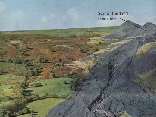
Colour image of the Aberfan landslide site after the 1966 disaster, showing the location of the 1944 landslide scar
.
As the tribunal noted:
It is difficult to exaggerate the importance of this slide in 1944. To all who had eyes to see, it provided a constant and vivid reminder (if any were needed) that tips built on slopes can and do slip and, having once started, can and do travel long distances. Mr. Geoffrey Morgan, while denying (in common with the vast majority of the witnesses) any appreciation of the possibility that a tip slide could ever reach Aberfan village, conceded that”. . . once a tip of considerable proportions on a mountainside does slip, it is impossible to predict how far it will reach”.
The 1963 landslides in Tip Number 7
The 1966 disaster occurred on Tip Number. Sadly, this spoil heap had failed previously, in 1963, probably more than once. In fact the Tribunal provides little technical detail about this set of landslides, noting with barely contained anger that the National Coal Board had not been very forthcoming about the events. The tribunal quotes Mr. W. R. King, the National Union of Mineworkers’ Lodge secretary:
“What I noticed on the day that I had a look at the tip in November (1963) was as if somebody had scooped the middle of the tip out with a huge shovel and also that the base of the tip had run forward. There was a distinct hole in the centre of the tip, and the top plateau of the tip had sunk a little, and the other feature then was the fact that slurry had run down for a considerable distance. . . . The hole extended up two-thirds of the tip itself . . . from the bottom. The width, as far as I could recall, (was) about 80 to 90 yards.”
Later the report provides a little more detail:
Although on Day 65 Mr. Piggott, the National Coal Board expert, accepted that . . . “there were signs of failure and degrees of failure on the tip from about 1963 onwards”, it was not until the 66th sitting of the Tribunal that the issue of whether or not there had been a slide of Tip 7 late in 1963 was removed from the realm of controversy. This was when Professor Nash, the expert witness called by the National Coal Board, agreed that the relevant aerial photograph established (a) that there had been a rotational slip of the tip which was quite different from a tailings run, (b) that a big volume of material had moved, though it might not have moved very far, and (c) that the result of this movement would inevitably have been observed by any proper investigation of the tip.
The Tribunal notes that the slope showed signs of movement and deformation from then right up until the failure. The Tribunal notes that:
Two convincing witnesses, Mr. D. T. Jones and Mr. M. W. Maybank, testified that they were able to judge by reference to a dead tree (known locally as Hangman’s Tree) on the mountainside that during the last six months before the disaster the toe of Tip 7 advanced downwards by some 20-30 feet. There is credible evidence that in the last three to four months there were frequent sinkings of the top of the tip of up to four feet and that a few times during that period the sinkings were of 10-12 feet. These occurred right across from one side of the tip to the other at the point where a ridge had existed ever since the major slide of 1963.
A failure to learn lessons
It is now clear that, in addition to the failures described in the report, other slips and flowslides occurred in spoil heaps in the South Wales coalfield. The failure to learn lessons from these multiple accidents, and the lack of recognition that spoil heaps were hazardous, is extraordinary, especially as the risks had been documented. In addition, there was an extraordinary local failure to recognise that the tips at Aberfan were particularly problematic.
Despite this, not a single National Coal Board employee was prosecuted, dismissed or even demoted in the aftermath of the accident.
17 October 2016
The Aberfan Disaster: a simple guide to what happened
The Aberfan Disaster: Aerial photograph from the east on the day of the disaster, image from the official tribunal
The Aberfan Disaster: a simple guide to what happened
Friday will mark the 50th anniversary of the Aberfan disaster in South Wales, Britain’s worst landslide disaster in which 116 children and 28 adults were killed. I will make a series of posts about the accident this week, but as a reference point I thought I would start by briefly reviewing the events of the day. Much of this is drawn primarily from the official investigation.
The village of Aberfan
Aberfan is a small Welsh village close to Merthyr Tydfil, in an area that was a powerhouse for coal mining. In 1966 the village was still dominated by mining, primarily in the adjacent Merthyr Vale colliery. The waste from this mine was tipped in a series of slag heaps on the slopes above the Aberfan. In the centre of the village, directly below one of the tips (Tip Number 7) was the Pant Glas Junior School.
On the day of the disaster, a crew arrived at Tip Number 7 to begin work at about 7:30 am. On arrival they noted that the tip had started to slide, with the track for their crane having deformed by about 3 metres. Unfortunately they did not have a telephone, so were unable to report the problems quickly (a worker was sent down to report the problem), but they resolved to move the crane back from the edge of the slide and to sever the overhanging rails. By 9 am the tip had subsided by another three metres. The report provides first hand testimony from the tipping crew of what happened next. These are the words of Gwyn Brown, the crane driver:
“I was standing on the edge of the depression. I was looking down into it, and what I saw I couldn’t believe my eyes. It was starting to come back up. It started to rise slowly at first. I still did not believe it, I thought I was seeing things. Then it rose up after pretty fast, at a tremendous speed. Then it sort of came up out of the depression and turned itself into a wave — that is the only way I can describe it — down towards the mountain . . . towards Aberfan village . . . into the mist.”
And these are the words of Leslie Davies, the charge-hand:
“When [Gywn Brown] shouted, we all got to the top of the tip and all I can tell you is it was going down at a hell of a speed in waves. I myself ran down the side of No. 3 tip all the way down towards No. 2 and No. 1 tip on the side. As I was running down, I heard another roar behind me and trees cracking and a tram passing me. I stopped — I fell down in fact. All I could see was waves of muck, slush and water. I still kept running . . . I kept going down shouting. I couldn’t see, nobody could. And I heard a voice answer me and he shouted, ‘Come out of there, for God’s sake’. That man was Trevor Steed . . . I went with Trevor Steed down on to the old railway line. By that time my mates had come down with me, behind me. We went along the line as far as we could towards the school, which we could see. All the houses were down. We could not pass that way because there was too much water rushing down . . . we could not go the way we wanted to go.”
The landslide involved about 105,000 cubic metres of spoil, which travelled at 17 to 34 km/h over a distance of about 500 metres. The landslide struck and engulfed 16 houses and Pant Glas Junior School. In total the Aberfan Disaster claimed 144 lives, and injured a further 35 people, most of them children.
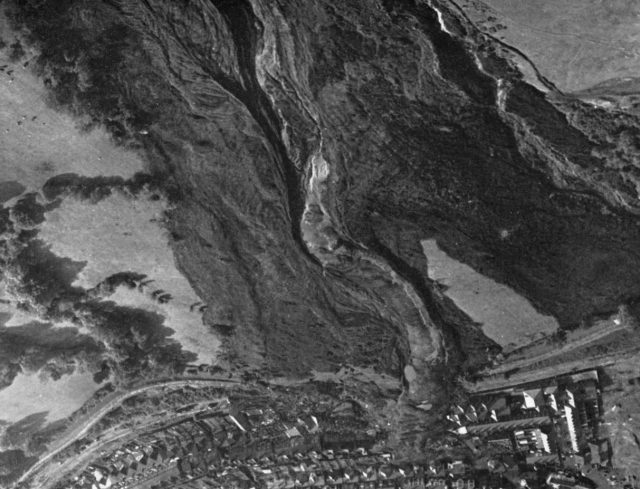
The Aberfan Disaster: View of the slope three hours after the disaster. Shows flow-slide with central mud-run, image from the official tribunal
The event was marked by haunting photography of the miners desperately digging through the waste in the destroyed school to try to save the children. However, the chances of surviving burial in this sort of landslide is low; the last survivor was recovered less than two hours after the accident.
In my next post I will describe the appalling actions by the National Coal Board. The Official Report is deeply critical of them, both in terms of their actions prior to the disaster and in terms of the way they approached the tribunal investigation the Aberfan disaster.
On the former point the report states:
While doubtless officials of the South Western Division, with their local knowledge and their awareness of slips which had actually occurred in the past, were more at fault, we cannot escape the conclusion that the Board must at national level also be blamed for its neglect of the stability of tips….Theirs was the overall responsibility for the initiation of policy, which involved that at national level there should have been due consideration of the proper methods to dispose of the waste of the coal-mining industry.
With regard to their approach to the tribunal:
On the other hand, if it really be the case that those with expert knowledge advising the National Coal Board had, even before the Inquiry began, come to the conclusion that the Board was to blame for the disaster — and that is precisely what Mr Piggott under cross-examination admitted…it is vastly to be regretted that the Board did not make this clear at the outset.
16 October 2016
JTC1 Workshop: Advances in Landslide Understanding
JTC1 Workshop on Advances in Landslide Understanding
JTC1 Workshop: Advances in Landslide Understanding
JTC1 (the Joint technical Committee on Natural Slopes and Landslides) has announced that it will hold the First JTC1 Workshop on “Advances in Landslide Understanding” in Barcelona, Spain from 24th to 26th May 2017.
The aim of the Workshop is to promote discussion on various aspects of Advances in Landslide Understanding, including:
- Brittle failures/ First time failures
- The transition between slow and fast motion
- The stability of weathered profiles
- Compound landslides
- Landslides in reservoirs
- Landslides in mines and tailing deposits
The organising committee has invited extended abstracts to be submitted, with the following schedule:
31st January 2017: Deadline for Extended Abstract submission
15th March 2017: Notification of acceptance of extended abstracts and registration opens
30th April 2017: Publication of final programme and end of early registration
10th May 2017: Late registration ends (without extended abstract submission)
20th May 2017: Online publication of extended abstracts (free access)
The organisers are inviting the submission of extended abstracts, which will be published in an electronic format book (Including ISBN). All accepted contributions will receive a slot for oral presentation in the workshop, which will strongly encoyrage discussion. The programme includes a number of keynote and invited lectures. The first day of the workshop will be a field trip.
Full details are provided in the conference website.
14 October 2016
Aletsch landslide: significant acceleration of movement
Aletsch landslide
The movement rate of the Aletsch landslide in Switzerland, which I highlighted last week, has accelerated significantly in the last few days. This is a very large rockslope failure – the estimated volume is up to 200 million cubic metres – at Moosfluh in the Riederalp, Canton du Valais, above the left flank of the Aletsch Glacier. Jens, a reader of the blog, kindly highlighted a report about the landslide, in German, on the Swiss SRF News website. This film should be visible below:
A translation of the key part of the report is as follows:
“The situation around the massive terrain movements on the Aletsch glacier has intensified in recent days. The fissures open up to 80 centimeters – daily…Large cracks in the ground – rocks that are slipping more and more: The hiking trails on the edge of the Aletsch Glacier are currently restricted areas…Geologists have been monitoring it around the clock for weeks.
The film shows the very extensive cracking that has now developed across the landscape:
Extensive ground cracking in the extensional component of the Aletsch landslide in Switzerland, via SRF
The report indicates that the landslide is moving faster than had been anticipated The report quotes the geologist from the canton:
“Everything is moving very fast, I have never seen such speeds,” says Raphaël Mayoraz.
An interesting dimension of this landslide is that a gondola the Moosfluhbahn – it even has its own Facebook Page – crosses the slope close to the landslide, constructed just last year. The upper station of the gondola was designed to move with the slope up to 11 meters horizontally and 9 meters vertically. At present the gondola remains open, and there does not seem to be major concern with regard to its safety..
The evolution of the slope will be fascinating to observe over the coming weeks.
Previous posts of interest:
- Aletsch: a major developing post-glacial rockslide
- The remarkable Preonzo landslide in Switzerland last week
- A fatal rockslide in Switzerland with major economic impacts
- Now that is what I call a divot! An unusual hazard on a golf course in Switzerland
- The Val Strem rockslide – a dramatic long run out landslide in Switzerland
 Dave Petley is the Vice-Chancellor of the University of Hull in the United Kingdom. His blog provides commentary and analysis of landslide events occurring worldwide, including the landslides themselves, latest research, and conferences and meetings.
Recent Comments