
7 December 2021
An update on the Mira Mar landslide in Albany, Australia
Posted by Dave Petley
An update on the Mira Mar landslide in Albany, Australia
In October I wrote about an ongoing landslide that is causing very significant problems for the residents of a neighbourhood in the Mira Mar suburb of the city of Albany in the southern part of Australia. At this spot a slow moving landslide has progressively destroyed or damaged a number of houses. The event remains contentious, with claims and counter-claims as to whether the cause is high levels of rainfall or the leakage of a water main. The slope has been moving since at least 2013, but it dramatically accelerated in the winter of this year. On 30 July a water main ruptured.
Last week a geotechnical report was released by a consultant, CMW Geosciences, commissioned by the Great Southern Development Corporation. This has been placed online. This is not a detailed site investigation, but it is instead primarily a desk study. However, this site has been extensively studied in recent years, and there is a movement monitoring record for the last few weeks, so the study usefully summarises the state of play.
Perhaps strangely, the report contains neither an interpreted plan view of the landslide nor an interpreted cross-section. I would be interested to know why this is not present. At the back of the report there are photographs of the landslide, including these images of surface damage:-
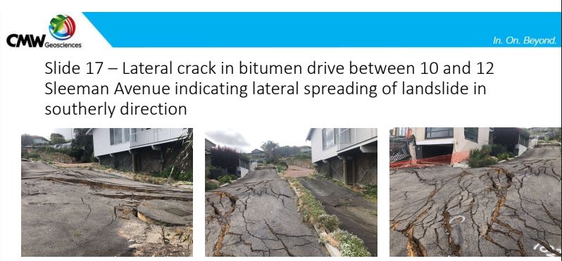
Ground deformation in the Mira Mar landslide in Albany, Australia. Image from a geotechnical report by CMW Geosciences.
.
The report concludes that the landslide is complex, active and extending in size. It also notes that groundwater is likely to be the cause of the landslide, but it is clear that it is not possible to determine whether the source was rainfall or leakage. The report recommends that dewatering of the landslide is enhanced. In the short term the report recommends that two houses (10 and 12 Sleeman Avenue – see image below) are demolished – the damage to the houses means that they are unsafe and demolition would provide access for investigation and remediation. Finally the report recommends a more detailed investigation, using Lidar to understand the topography and morphology of the slope, and boreholes to understand the subsurface geometry, materials and pore water pressures. All of these recommendations seem reasonable.
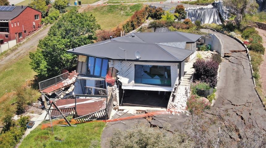
Damage to a house caused by the Mira Mar landslide. Image from ABC Great Southern: Tom Edwards
.
The Minister for Regional Government has provided a response to the report that indicates that a further three properties will be evacuated, that AUS$150,000 will be made available for further investigations and that dewatering will be supported. It is probably true to say that the response has not been welcomed by those affected by the landslide.
This event is a nightmare for the residents of the properties on the landslide, and for those living around it. The report is correct in noting that the long term solution will need to address the stability of the whole landslide system, not individual properties. This is entirely possible from an engineering perspective, but it will be complex and expensive, and will require a long period of investigation, planning and construction.
 Dave Petley is the Vice-Chancellor of the University of Hull in the United Kingdom. His blog provides commentary and analysis of landslide events occurring worldwide, including the landslides themselves, latest research, and conferences and meetings.
What I see in the report : First movement in 2013 during the construction of 7th block of Anzac rd, a big retaining wall almost parallel to the slope below the 7 a,b,c block of Anzac rd (which is the toe of the landslide, see the 7block construction on google st view ), groundwater flowing into the site material (especially, again, at the 7abc block on Anzac rd, where “the vegetation is greener” said the geotec report, and, also the most important to me : “Groundwater Spring within the block of 7 Anzac Road” (see page 6). Dewatering system only above the slide, one below would have been not bad as well. Reminds me of the 1930 Fourvière cathedral landslide (“Catastrophe de Fourvière” on wikipedia if you want to have a look)… the cause was the progressive obstruction of more or less old drainage systems (some of were old roman drainage galleries…) by modern constructions. Groundwater accumulated into the slope, until the landslide happened. I see similarities (and if you had a leakage, it’s worse).