30 November 2021
Ananea: a significant mine waste failure in Peru
Posted by Dave Petley
Ananea: a significant mine waste failure in Peru
On 26 November 2021 a significant landslide occurred in mine waste near to the town on Ananea in Peru. I will say from the start that I am finding it extremely difficult to piece this event together as there is a wide range of conflicting information and images. I am unsure as to whether this was a single event or a series of related failures, and I am unsure as to the level of damage. Unfortunately at present there is no good satellite imagery.
I would welcome any insight that anyone can provide.
I’ll try to set out what I do know. The official COEN-INDICI (Centro de Operaciones de Emergencia Nacional) Twitter site confirms that an event occurred on that date:-
#COENInforma
El 26/11 se produjo un #Deslizamiento que causó daños a viviendas y carretera en el distrito Ananea, provincia San Antonio de Putina (Puno). Autoridades locales evacuaron a las personas afectadas y coordinan su reubicación. (1/2) pic.twitter.com/gEqFENttIr— COEN – INDECI (@COENPeru) November 29, 2021
.
The translation is: On 11/26 there was a #landslide that caused damage to homes and roads in the Ananea district, San Antonio de Putina province (Puno). Local authorities evacuated the affected people and are coordinating their relocation.
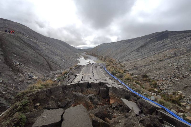
The photograph shows the aftermath of a large landslide. There is also a set of images on the Sin Fronteras website, with a set of photographs. The text says:
ANANEA. IN THE CHAOS! THE OVERFLOW OF THE MINING TAILINGS FROM A SEDIMENTATION POOL HAS LEFT THE ANANEA DISTRICT, IN THE SAN ANTONIO DE PUTINA PROVINCE, WITH THE STREETS FLOODED WITH MUD AND IMPASSABLE, SO THE RESIDENTS ASK THAT IT BE DECLARED IN EMERGENCY.
The overflow occurred yesterday at 8:30 in the morning, apparently from one of the sedimentation ponds of the San Antonio mining cooperative, located on the Q’oñiunu hill.
The collapse of the highly toxic material would have occurred due to the alleged negligence in the management and control of the mining waste pools; irresponsible work of some cooperatives.
It also includes some images, but I cannot figure out how they all fit together:-

An image of the aftermath of the landslide at Ananea in Peru. Image from Sin Fronteras.
.
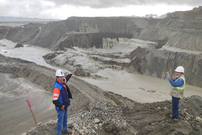
The image above is consistent with that tweeted by COEN. However, another image appears to show a different site altogether:-

An image of the aftermath of the landslide at Ananea in Peru. Image from Sin Fronteras.
.
There are also some videos of a flood event circulating, such as this one on Tic Toc, and this one on Twitter:
Desastre ambiental en mina de #LaRinconada en #Ananea #Puno. Dirá algo la Primera Ministro o su chamba es solo destruir valor bursátil de empresas mineras formales.
Esta es la minería que Contaminación, esta es la minería que apoya #Castillo #Cerron #Vasquez y #Mendoza pic.twitter.com/QnQOk5cQKF— ★Luis Romero★ (@luroel) November 29, 2021
But again I am unsure as to whether this is the same event.
Can anyone shed any more light on this event, or set of events?


 Dave Petley is the Vice-Chancellor of the University of Hull in the United Kingdom. His blog provides commentary and analysis of landslide events occurring worldwide, including the landslides themselves, latest research, and conferences and meetings.
Dear David,
It looks like a slope failure occurred on the slopes above the sediment lake. It looks like a translational failure which “pushed” water and sediment out of the pond and down the hill (aligned with the road) towards the village. Maybe it was not only one slope failure but a couple but one significant that produced the wave. Or some photos may be old (sometimes news sites do not have actual footage and use previous ones)
Not that easy, but I presume the tiktok video that shows the minivan making a U-turn in front of the flood is taking place at this spot : -14.682476°, -69.528006° (you can see the rectangle building and the blue roof building in the background). So the landslide/dam failure seen in the image must be above this place, looking at the slopes on latest images of google earth, maybe this spot : -14.685898°, -69.517704°… But I can’t see the relation with the damaged road… Hope I helped a little. (Thanks as usual for the posts).
Adding some new informations ; found this picture (https://radioondaazul.com/ananea-identifican-peligro-inminente-por-lagunas-artificiales-construidas-por-operadoras-mineras/) showing an aerial view of the upraised road destroyed by a landslide… pretty sure the location is here : -14.686312°, -69.515816°… and if my prevous comment is true… it is just above the location if the dam failure (-14.685902°, -69.517749°)…! Now we have an interesting “near geographical events” chonology to find out! Is it possible that a first landslide (looks rotational), impacting the road then the tailing dam just in front of it, makes this last one collapse as well, resulting in the mudflow ? That would be pretty crasy… but like Jame said, this a land where disasters are wainting to happen.
What a devastated landscape. Indiscriminate, uncontrolled mining. Makes Aberfan look like a holiday resort……
Holiday Resort! What a truly awful comment, I can only hope that you have a very limited knowledge of the Aberfan disaster.
Your location is correct. The road goes through the middle of concession 13000004Y02 owned by CENTRAL DE COOPERATIVAS MINERAS SAN ANTONIO DE POTO DE ANANEA LIMITADA (CECOMSAP). https://geocatmin.ingemmet.gob.pe/geocatmin/
Dues were owing. They have more concessions up the road. The town of Ananea sits on the concession of another co-op.
The dam on the north side breached. The large dam along the road was built encircling a number of small ponds. The south dam was similarly built and starts 200 m east of where the north dam failed. The two men in the Sin Fronteras photo are standing on the edge of the south dam.
Armoured diversion channels through the town were finished in June 2022, 70% paid for by CECOMSAP.
https://larepublica.pe/sociedad/2022/06/29/puno-ananea-es-protegida-con-una-defensa-ante-posibles-desbordes-de-relaves-mineros-lrsd/
There’s plenty of danger upstream.
Peru mines database: https://www.minem.gob.pe/_publicacion.php?idSector=1&idPublicacion=652