24 July 2023
An update on the 19 July 2023 Irshalwadi landslide and a catastrophic debris flow in Bhutan
Posted by Dave Petley
An update on the 19 July 2023 Irshalwadi landslide in India
The rescue and recovery operation for the 19 July 2023 Irshalwadi landslide in India has now been terminated. In total, 27 bodies were recovered. A further 57 people have now been recorded as having been killed but not recovered, leaving a total toll of 84 people, making this the most deadly event of the 2023 Northern Hemisphere monsoon to date.
The focus us now on those left homeless by the landslide. The Indian Express has an article that notes that commitments have been made to rehouse the survivors. I very much hope that this happens, but around the world the record is not good once the focus shifts to the next event.
[I have removed the image that was originally here as it turns out it was a different landslide].
Heavy rainfall continues across parts of India, with Uttarakhand being particularly at risk this week.
.
The 20 July 2023 debris flow at Ungar in Lhuentse, Bhutan
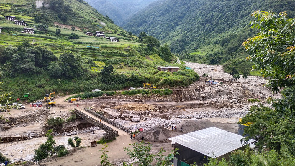
Meanwhile, on 20 July 2023 a debris flow hit Ungar in Lhuentse in Bhutan. Whilst this has been reported as a flash flood, the descriptions match that of a debris flow. Khuensel has an article providing the latest information – to date seven bodies have been recovered and a further 16 people are missing, with no prospect of survivors. It appears that the debris flow struck a camp that was housing workers from Druk Green Power Corporation.
“The victims included Druk Green Power Corporation employees like work supervisor, section officer, surveyors, machine operators, electricians, and plumbers.”
And
“Machinery like excavators, air compressors, bumping machines, rod bending and other machines were lost to the flood. The eight private light vehicles were also damaged.”
The camp had been established as part of the Yungichhu Hydropower Project. I have noted previously that many hydroelectric schemes in the Himalayas pay inadequate regard to the landslide risk; this could be another such case.
Interestingly, Google Earth has a site marked as “Yangichu hydroproject campsite” at [27.5263, 91.1281], but I cannot confirm whether this is the location of the disaster.
Another Kuensel article has a image of the aftermath of the debris flow:-

The aftermath of the 20 July 2023 debris flow at Ungar village in Bhutan. Image from Khuensel online.
.
There are reports of cloudburst events in the region at the time, so it is likely that this disaster was caused by localised, very intense rainfall.


 Dave Petley is the Vice-Chancellor of the University of Hull in the United Kingdom. His blog provides commentary and analysis of landslide events occurring worldwide, including the landslides themselves, latest research, and conferences and meetings.
There’s a place much further down the valley than that, which is marked as the Yungichu Hydroproject Campsite on Google maps ( 27.526185°, 91.128159°) . You can see the same bridge that’s in the Photo (orientated in the same way along with the roadway matching up with the one seen in the photo. I’m thinking the confusion comes from the Buildings in the background. Newest pic is dated 12/26/2020. So it’s possible that the y have been built in the last couple of years