11 July 2023
The Rolling Hills Estates landslide in California
Posted by Dave Petley
The Rolling Hills Estates landslide in California
It has been a busy few days in the landslide world, with major events being reported in various locations. The most serious is likely to be the extreme rainfall event that has hit Himachal Pradesh and Uttarakhand in northern India, but the true picture there remains somewhat unclear. There has also been extreme rainfall, with resultant landslides, in China, Japan, the USA, Turkey, Pakistan and elsewhere. The northern hemisphere summer rainy season is only just getting going, so there is likely to be a lot more to come.
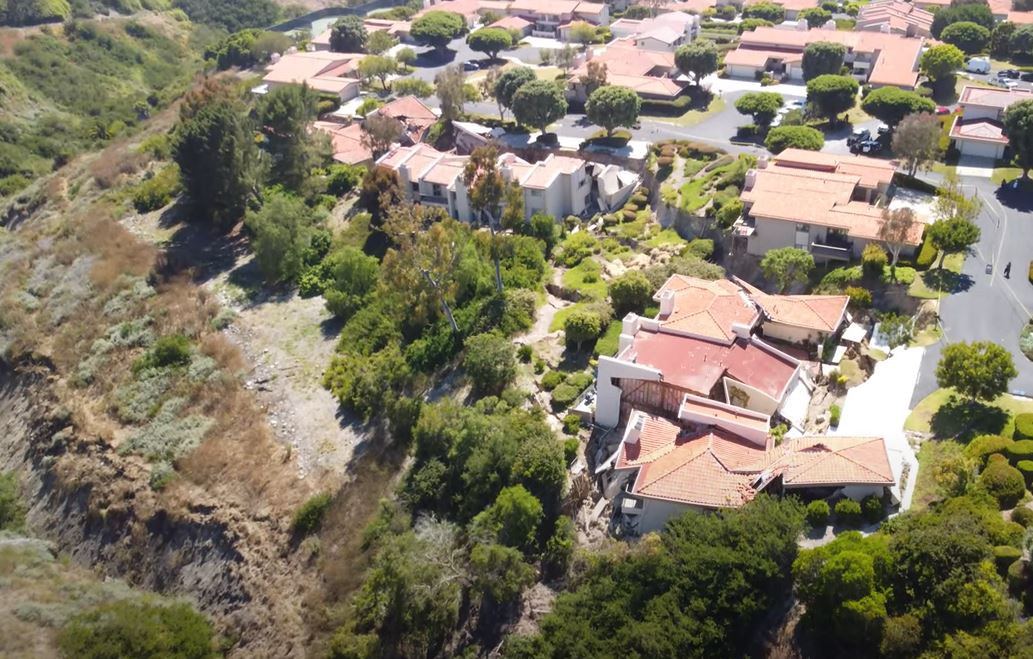
Meanwhile, in California a major landslide impacted (the ironically-named) Rolling Hills Estates, in Los Angeles County, located on the northern side of the Palos Verdes Peninsula. The landslide started to move rapidly on 8 July 2023, and reports indicate that movement is continuing. Reports indicate that 12 houses have been damaged or destroyed on Peartree Lane. The location of the landslide is approximately [33.7637, -118.3888].
John Kay has posted a drone video of the site to Youtube, which is worth viewing:-
.
This is a still from that video:-

The 8 July 2023 landslide at Rolling Hills Estates. Still from a drone video posted to Youtube by John Kay.
.
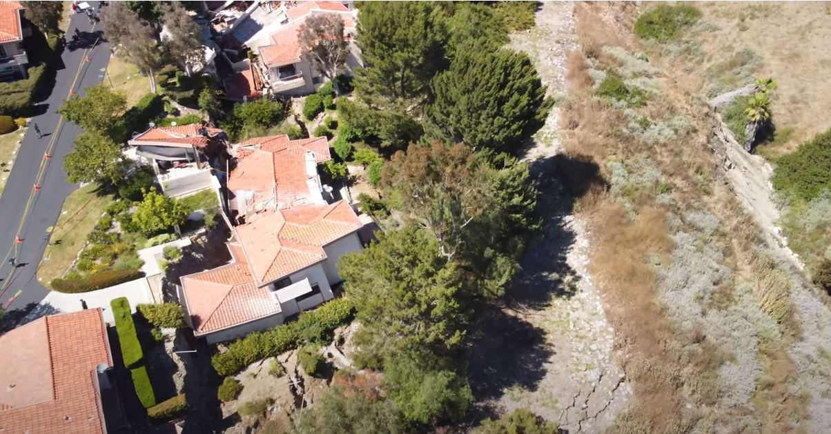
Whilst this is a view from a different angle:-

An alternative view of the 8 July 2023 landslide at Rolling Hills Estates. Still from a drone video posted to Youtube by John Kay.
.
On first inspection this appears to be a slump, possibly driven by toe erosion in the canyon?
Loyal reader Funkenbeachin has kindly put together an animation of the site using the 1 m DEM, which might support the above interpretation:-
.
This video also shows very clearly that this area of California is no stranger to landslides, including the Portuguese Bend landslide.
This event will of course be a devastating blow to the owners of the properties affected, all of whom have been evacuated. The images above suggest that at least some of these houses will not be habitable.
.
Acknowledgement
Many thanks to various people who contacted me about this event.


 Dave Petley is the Vice-Chancellor of the University of Hull in the United Kingdom. His blog provides commentary and analysis of landslide events occurring worldwide, including the landslides themselves, latest research, and conferences and meetings.
FYI this is a good thread as to the cause of the landslide
https://twitter.com/mrbrianolson/status/1678432356909334528
This sort of activity is common on the coast (see San Clemente, Pacific Palisades, etc.) and we had an exceptional rain year with the much of it sweeping in from the south onto slopes that don’t usually face the brunt of the rain.
A more specific reason is the Palos Verdes/Rolling Hills area (PV Peninsula) is bounded on the east and north by the late Pleistocene-Holocene active Palos Verdes fault zone, which has caused folding and faulting of the Miocene marine sedimentary rocks. This has made the area prone to landslides. Given typical SoCal hillside development, it is also likely that there was fill placed on the upper slope to make the building pads.
Note in the comments on the DEM pan ( https://youtu.be/xmL_UkD_JFY ), @cammyfayes has found that the landslide is in fill built in the ’70’s, below (south) of Peartree Land, on a pair of old landslide deposits (Qols).
A new movie reviews USGS topographic maps of 1951, 1963, 1996: https://youtu.be/FLn1y2Roz58
Here is where the fill placed in 1972-80 was found: A commercial website: https://www.historicaerials.com/viewer
Copy the lat/lon 33.7637, -118.3888 Paste in the search box by ctrl-v. Choose aerials, then the year. See 1972, no fill at the slide site, then 1980, fill and structures at the site. It appears that the fill was built on a pair of old slumps, 2 arcuate head scarps and a terrace on the bodies, the stream is deflected to the southeast. The damaged homes are on fill which failed. On the northwest side of Peartree Lane, homes on older fill, see 1963 image, are not damaged, In the 1952 images, looks like hay fields. Thanks to @cammyfayes for finding this.
I think the Sentinel-1 radar, as good as 5m resolution, may see the Peartree landslide. Using less energy, I did the difference between Sentinel-2, 10m, band 8, between July 7 and 12. Some more spots of change up and across the canyon and behind Peartree Lane. https://youtu.be/dNhbqfziUDk
See a pan of Sentinel-2 true color images and pixel value change map https://youtu.be/JykOp52n_pI The landslide is just visible in the before/after images.
For the people purchasing these properties, discovery of the historical fills would not have been easy. I hope their insurers pay up.
Another video https://youtu.be/0zNdWKXhnko explores soil moisture, before and after rapid movement of the landslide.