
28 June 2023
Planet satellite image of the 11 June 2023 Flüchthorn rock avalanche
Posted by Dave Petley
Planet satellite image of the 11 June 2023 Flüchthorn rock avalanche
Once again my friends at Planet have captured a remarkable satellite image of a landslide. They have imaged, using their high resolution SkySat instrument, the 11 June 2023 Flüchthorn rock avalanche. This is the image:-
Planet SkySat image of the 11 June 2023 Flüchthorn rock avalanche in Austria. Image, captured on 18 June 2023, copyright Planet, used with permission.
.
The image above has not been orthorectified (i.e. it is shown from the perspective of the instrument). This is corrected in the version of the image below:
Orthorectified Planet SkySat image of the 11 June 2023 Flüchthorn rock avalanche in Austria. Image, captured on 18 June 2023, copyright Planet, used with permission.
.
I have also imported the image into Google Earth, and have draped it onto the topography:-
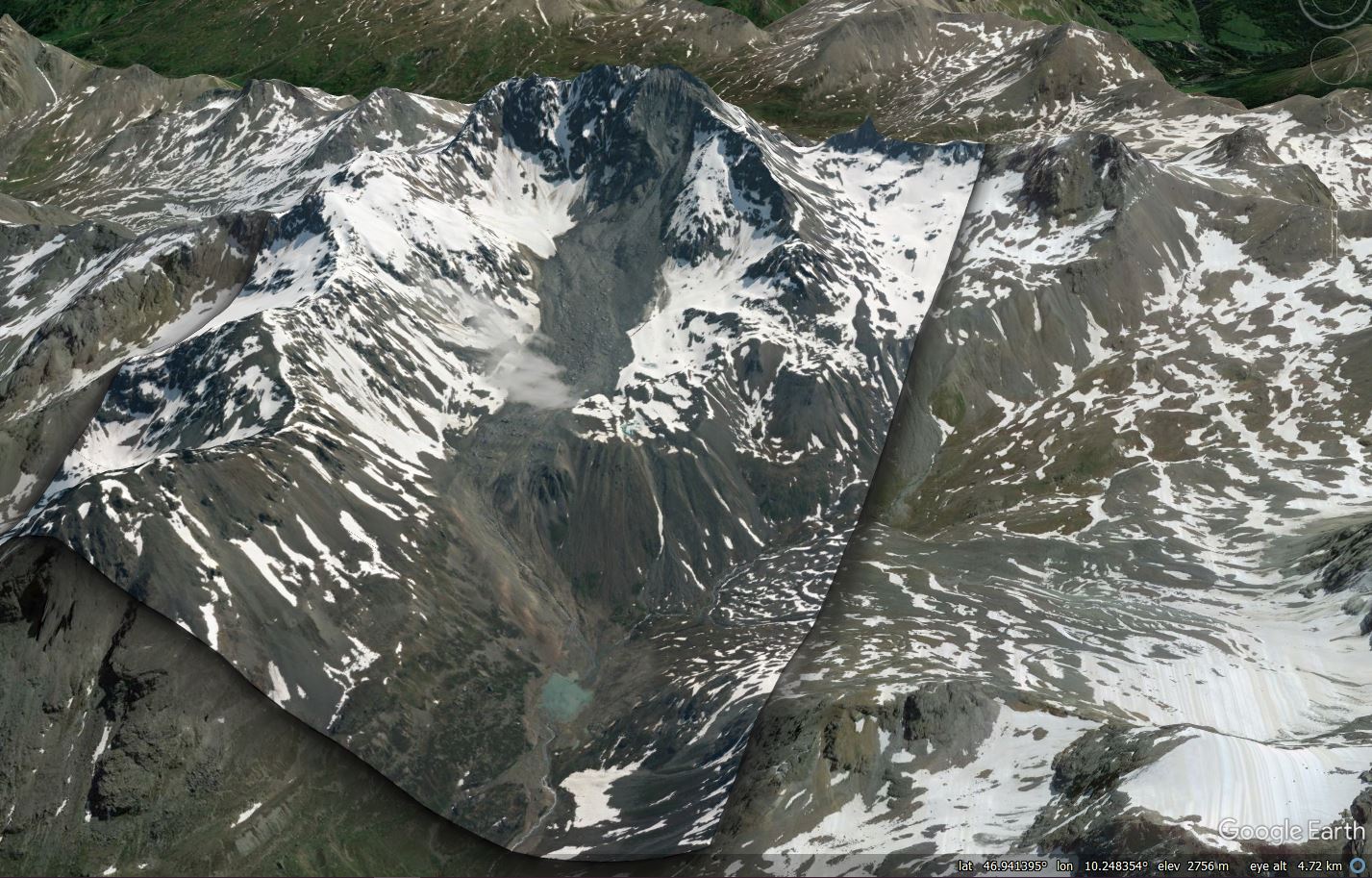
Orthorectified Planet SkySat image of the 11 June 2023 Flüchthorn rock avalanche in Austria, draped onto Google Earth topography. Image, captured on 18 June 2023, copyright Planet, used with permission.
The image captures very beautifully the steep source zone of the landslide and the very bouldery upper portion of the deposit. The transition into a debris flow, probably because of the entrainment of ice and saturated sediment as it crossed the upper plateau, can be seen. Almost no deposition has occurred as the landslide descended the steep lower slope. The landslide has scoured the sediments at the foot of the steep lower slope but has then started to deposit material, allowing a small lake to form. The width of the flow dramatically reduces from this point onwards.
It is extremely fortunate that no-one was in the path of this dramatic landslide.
It is also worth noting that the failure also caused a small landslide on the other side of the Flüchthorn:-
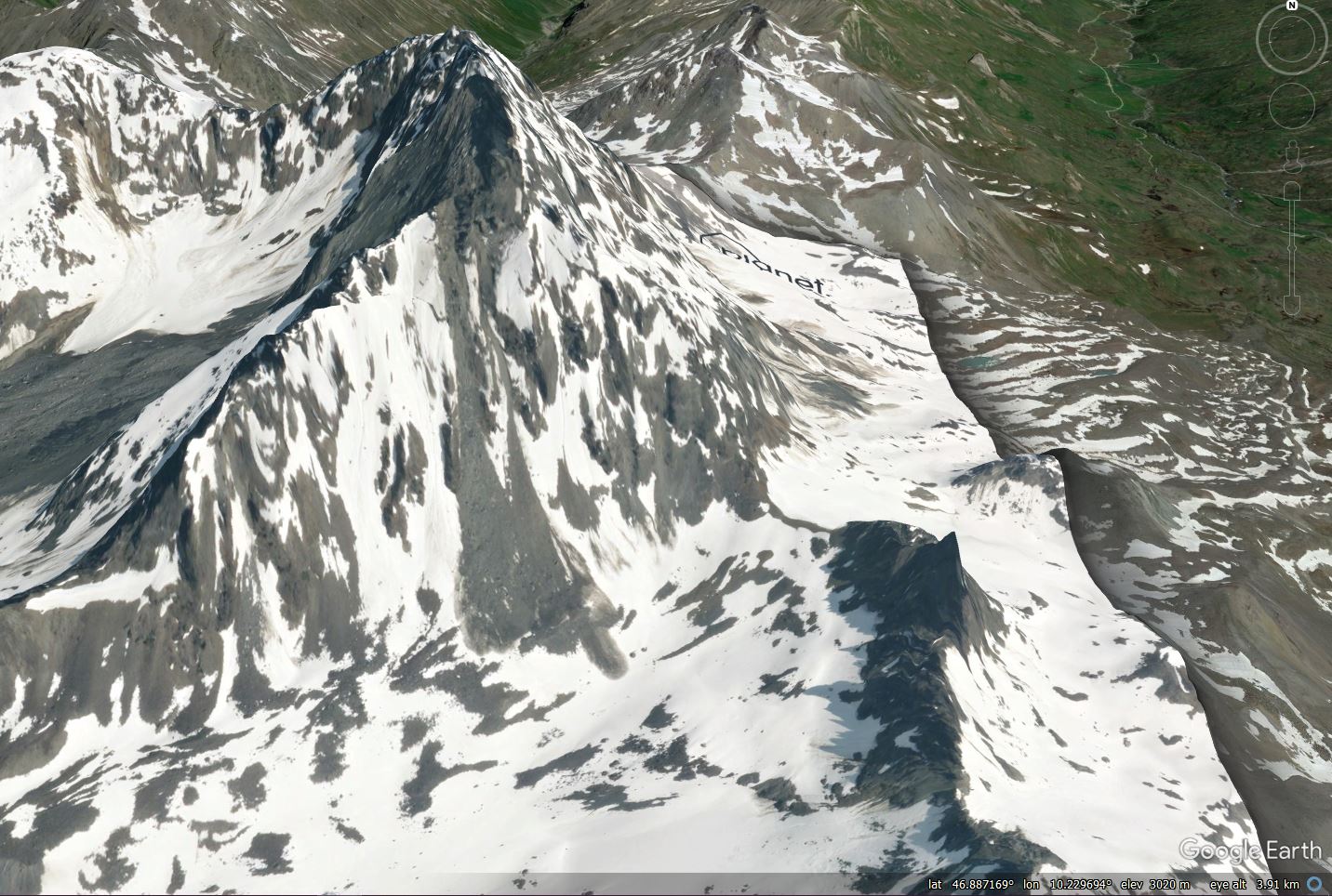
Orthorectified Planet SkySat image of the other face of the Flüchthorn, draped onto Google Earth topography, showing another small landslide. Image, captured on 18 June 2023, copyright Planet, used with permission.
.
Acknowledgement and reference
Planet Team (2023). Planet Application Program Interface: In Space for Life on Earth. San Francisco, CA. https://www.planet.com/
 Dave Petley is the Vice-Chancellor of the University of Hull in the United Kingdom. His blog provides commentary and analysis of landslide events occurring worldwide, including the landslides themselves, latest research, and conferences and meetings.
I notes a series of smaller slides in the image. Wondering if these were triggered by the larger slide, or if they are common this time of year.
25 June 23 clear sky, natural color, Sentinel-2 satellite image yielded a decent footprint of the slide:
https://youtu.be/lqsV57K0YKg
Yet another landslide footprint from the Planet image, georeferenced and draped on the 1-m DEM: https://youtu.be/ae09YmlOcW0