
29 March 2021
Yarlung Tsangpo: another giant, high mountain landslide on 22 March 2021
Posted by Dave Petley
Yarlung Tsangpo: another giant, high mountain landslide on 22 March 2021
On Friday evening, as I was queueing to receive the first dose of the Oxford / Astra Zeneca vaccine for Covid-19 (a wonderful day), I received an email from Göran Ekstrom of Columbia University making a small group of us aware that he had detected, using seismic instruments, a probable large-scale landslide in the vicinity of the Yarlung Tsangpo in Tibet. As always, the seismic data gives an indication of location, but not a precise grid reference, and an idea of the mass (in this case about 100 million tonnes – a very large one indeed).
Fastest out of the blocks was Marten Geertsema, who used partially cloudy Planet Labs satellite imagery to identify a possible site. Yesterday, Planet Labs data with low levels of cloud became available. Dan Shugar from the University of Calgary was able to identify that the location was correct, and that a large landslide had occurred:-
https://twitter.com/WaterSHEDLab/status/1376247670419808259
.
This is the Planet Labs image of the site, captured yesterday:
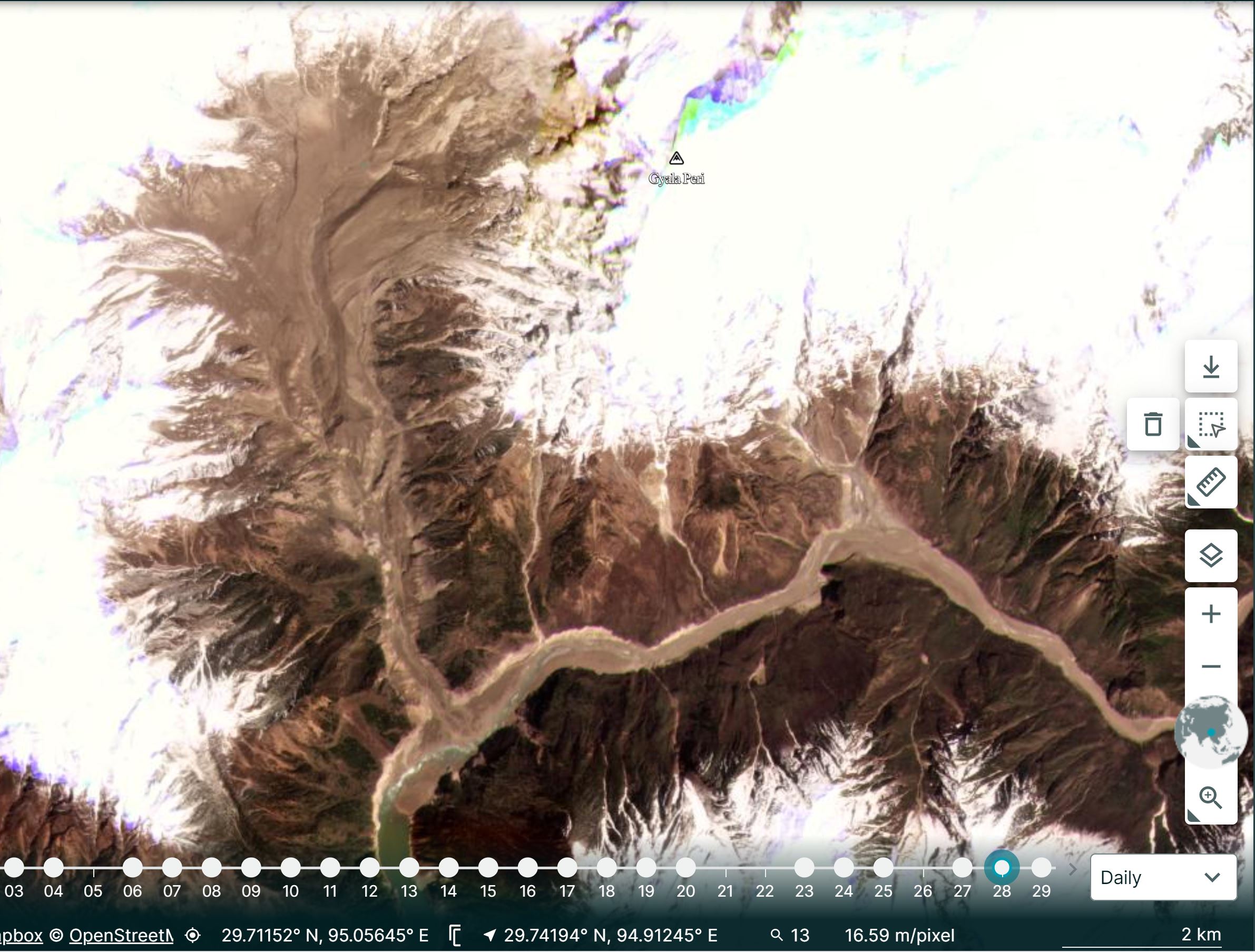
Planet Labs image of the 22 March 2020 landslide at Tsangpo in Tibet. Image cop right of Planet Labs, used with permission.
.
The coordinates of the site, 29.815, 94.932 are the centre of the landslide source. Note the scale in the bottom right corner.
Dan and I slightly disagree with how this (and Chamoli) should be described (which is fine of course). Dan describes this event as the collapse of hanging glaciers, whereas I consider it to be a rockslide that has taken some ice with it. Researchers love semantics! Either way, at Yarlung Tsangpo it is clear that a large amount of rock and ice have detached from the east side of the tributary valley, moving westwards and then to the south. Once again this has formed a catastrophic channelised flow that has travelled down the channel to deposit a large volume in the main channel. This was probably blocked briefly, but as the image above shows water is now flowing freely.
Note the huge increase in turbidity of the water downstream of the blockage on the Yarlung Tsangpo.
Stuart Dunning of Newcastle University tweeted a very interesting aspect of this site yesterday in response to a tweet from Dan:-
@davepetley active place this! pic.twitter.com/wdkPkZh1LM
— Stuart Dunning (@Rock_Avalanches) March 28, 2021
.
This must be one of the most dynamic landslide locations on Earth. I have previously written about another landslide at exactly the same site. That event looks broadly similar to this one.
As Dan’s tweet above notes, there is a discussion about hydropower development in this area. As with Chamoli, that would seem unwise given the landslide threat.
.
Reference
Planet Team (2021). Planet Application Program Interface: In Space for Life on Earth. San Francisco, CA. https://www.planet.com/
 Dave Petley is the Vice-Chancellor of the University of Hull in the United Kingdom. His blog provides commentary and analysis of landslide events occurring worldwide, including the landslides themselves, latest research, and conferences and meetings.
Dave – I agree entirely with your description above 🙂
[Thanks Dan. Dave]
I visited this area in 2017 with Chinese scientists before access for westerners became more difficult due to the border conflict with India. Due to the earth tremors and earthquakes, the very steep valley sides are extremely unstable. Driving along the single-carriage road a boulder as big as a minibus rolled slowly out into the road in front of us. The driver reversed rapidly as more rocks rolled onto the road. There is no alternative route and the local road gang swang into action and the road was reopened the next day. We passed in trepidation! Glacier snouts overhang the main valley in several places and landslide dammed lakes are common. Some prehistoric slope failures are so large they are difficult to identify in the field as they have similar scale to the valley walls.