
16 December 2020
Bute Inlet: a very long runout proglacial landslide in Canada
Posted by Dave Petley
Bute Inlet: a very long runout proglacial landslide in Canada
News has emerged over the last few days of a recent very large landslide close to Bute Inlet in British Columbia in Canada. This is a really big one – I think the runout is in the order of 13 km, based on a back of the envelope calculation from Google Earth. This landslide has been reported as a variety of phenomenon including a glacial lake outburst flood (GLOF) and a tsunami, and as loyal reader Hig points out below there is an element of these in the chain of events. The location is approximately 50.975, -124.609.
A good starting point is a set of videos posted to Facebook by 49 North Helicopters, who I think discovered the landslide. These show the track of the lower part of the landslide, which was confined within the valley below the glacier. You should be able to access them via the embedded tweets below:-
https://twitter.com/GeoBrentatlarge/status/1338535716813344768?s=20
.
Brent Ward from the Department of Earth Sciences at Simon Fraser University has been tweeting extensively about this landslide, and he has also appeared on the TV News to discuss the slide. His interpretation of the events is I think spot on, and my description here is based on this.
The full extent of the landslide can be seen on the Google Earth image, obviously captured before the failure, below. I have annotated the location of the original landslide, the position of Elliot Lake, the track of the landslide and the location of the outwash deposits:-
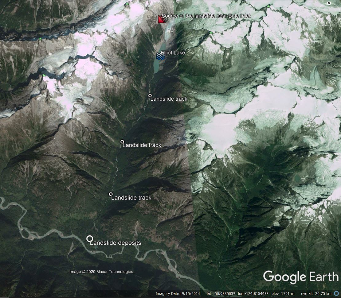
Annotated Google Earth image of the approximate details of the landslide near to Bute Inlet in Canada
.
Planet Labs has imagery from 2 December 2020 that captures the aftermath of the landslide – clearly the event occurred before this date. This is the source area of the landslide and the remains of Elliot Lake:-
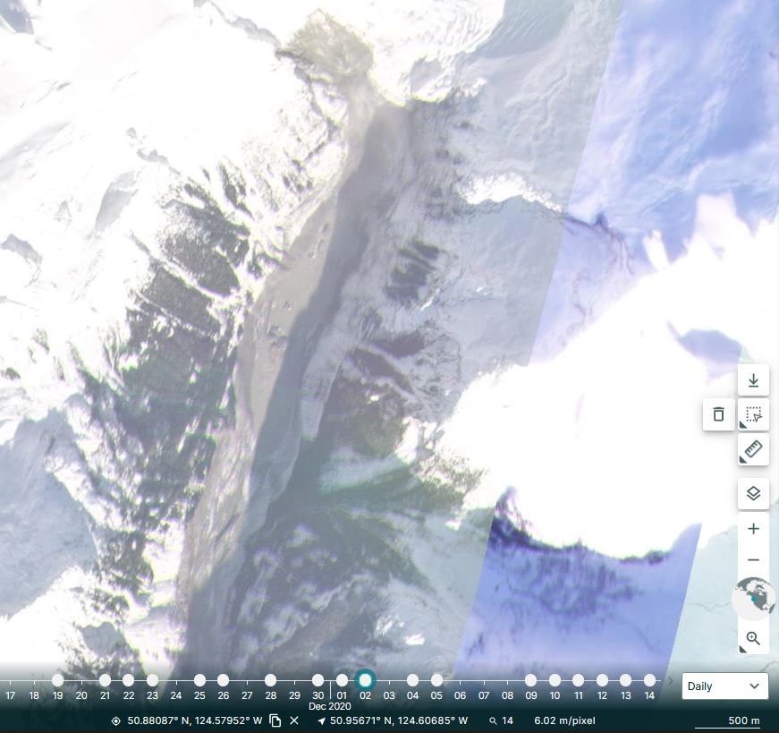
Planet Labs image of the landslide near to Bute Inlet in Canada. Image copyright Planet Labs, used with permission.
.
Note the scale bar in the bottom right corner of the image – this is a very large failure. The interpretation is that a large failure occurred on the rock slope to the west of the front of the glacier. The very large mass entered the lake, driving a huge displacement wave and entraining both the water and lake sediment to form a catastrophic debris flow (or a hypersaturated flow?) down the valley. The track of the flow is captured very nicely in the 49 North Helicopters videos. This is a still from one of them:-
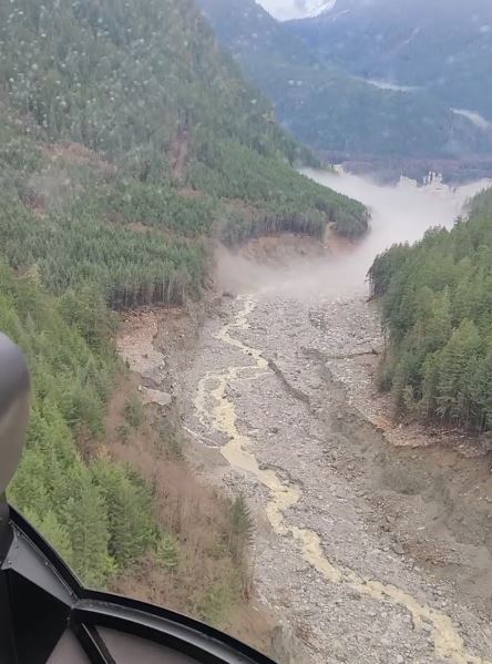
A still from one of the 49 North Helicopters videos of the track of the Bute Inlet landslide.
.
At the mouth of the valley there is extensive deposition of sediment:-
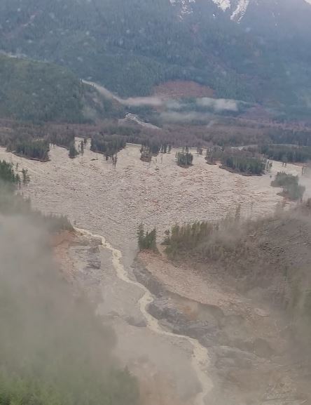
A still from one of the 49 North Helicopters videos of the lower part of the Bute Inlet landslide.
.
The flow then travelled westwards down the Southgate River into Bute Inlet, where a large amount of floating timber was observed.
This is a classic compound hazard chain – landslide, displacement wave, debris flow, debris flood and possibly even a submarine density flow in Bute Inlet.
Detailed analysis of this event may need to wait until the Spring, but good data should be available from the regional seismic network, which should yield data on the timing, volume and velocity of the event. It is very interesting that this large failure occurred very close to the snout of a retreating glacier – there are parallels to the Barry Arm landslide in Alaska.
 Dave Petley is the Vice-Chancellor of the University of Hull in the United Kingdom. His blog provides commentary and analysis of landslide events occurring worldwide, including the landslides themselves, latest research, and conferences and meetings.
I’m intrigued by your assertion “This landslide has been reported as a variety of phenomenon including a glacial lake outburst flood (GLOF) and a tsunami, but it is most definitely a landslide and associated debris flow.” I think that it’s reasonable to say it was all of the above. It seems to me that it’s clear there was a landslide, and it clearly generated a tsunami in the lake. This tsunami then exited the lake (possibly downcutting, but perhaps that wasn’t a significant piece of the story) as a flood. Given it’s a flood exiting a glacial lake, it seems fair to call it a GLOF at that point. And then perhaps it became a debris flow – I agree that’s what the track looks like in the heli videos, but I’m not sure we can rule out a surge of water that was mobilizing a lot of sediment but never actually reached the point where it was a proper debris flow. It’s also pretty clear there was a turbidity current in Bute Inlet, so add one more to the cascade of events beginning with glacial retreat and consequent landslide…
[Thanks, good point, I have amended the post to reflect your observations. D.]
Elliot Creek is a tributary of the Southgate River, which in turn flows to Bute Inlet.
[Thanks, corrected. D.]
What strikes me is how intact Elliott Lake is after the event. Comparing the GE and Planet Labs images, the lake is roughly the same shape and extent with perhaps some “islands” of debris in it. I would have expected much more infilling or draining, especially with the downcutting visible downstream.
In the GE imagery from 2014 there’s a hint of tension cracks at the failure zone, but that could be my imagination. It’s interesting to consider the role that glacial debuttressing may have played here, as you allude to.
Also, a colleague mentions that there were mapped large landslides in this valley prior to the event (which makes sense, given the terrain). He is trying to track down the original report that mentions them.
There was a good article on the CBC website.
https://www.cbc.ca/news/canada/british-columbia/landslide-bute-inlet-southgate-river-elliot-creek-lake-glacial-slide-triggers-wave-1.5840743
There was a good article on the CBC website regarding the event.
https://www.cbc.ca/news/canada/british-columbia/landslide-bute-inlet-southgate-river-elliot-creek-lake-glacial-slide-triggers-wave-1.5840743
Fascinating. “Beautiful” imagery. The hazard chain concept is reminiscent of compound disturbance chains in ecology as well.
I used Google earth to look at elliot lake it is northwest of 105 mile house.the lake that the landslide impacted has no name like many lakes in this province.
I used Google earth to look at elliot lake it is northwest of 105 mile house.the lake that the landslide impacted has no name like many lakes in this province.
Here is the link to a short video with processed Sentinel 1 data of the slide aftermath. You can see the GLOF path in red and some debris/ice islands in the lake. The red patch above the lake appears to be the slide scar. https://youtu.be/88tDws9t9co
Using Sentinel-1 data, it appears the landslide happened between the 26 and the 30 November: https://www.sentinelvision.eu/hyperlook/32b5a5643a3148b4b3bedb2989ddf0e6
Great summary. We are examining this as well as an example of extreme rainfall impacts and how to alert for such events. Your insight and discussions are very helpful! Thanks.
Thanks for the summary and insight. IMHO this should not be called a GLOF since it was not caused by glacial ice damming and sudden release as far as the evidence shows. Is there a more appropriate name for a mountain lake landslide induced flood or have a name more appropriate or a Glacial lake Landslide flood … such as MLLF or GLLF ?
The mechanism for glacial lake ouburst floods (GLOF) is specific to how Glacial ice dams water, and causes a sudden release of the lake connected to a glacier. The sudden release of water is due to frictional induced heating and erosion of the ice tunnel damming the water, and can be physically modeled to aid predictions.
This Nov 28 Bute Inlet area landslide-lake tsunami – periglacial event seems to be a dramatic example of landslide induced mountain lake tsunami formation, which is quite different from a glacial lake outburst flood (GLOF) . Both GLOF and MLLF are likely to increase as denudation of the landscape combines with more intense rainfall, wildly fluctuating freezing levels and rapid melt associated with global warming impacts. I hope at CMOS this year (AGM coming up later this month – late May to early June 2021) we can learn more about this event and trigger further insight and discussion with our presentations.
Great multimedia: https://hakai.org/the-big-slide/