
18 December 2020
Arequipa, Peru: landslides from a M=5.6 earthquake on 16 December 2020
Posted by Dave Petley
Arequipa, Peru: landslides from a M=5.6 earthquake on 16 December 2020
The city of Arequipa in Peru was struck by a M=5.6 earthquake at 17:48 UT on 16 December 2020. This was a comparatively deep earthquake (87 km according to the USGS) in an area with a history of significant seismicity. It is not expected that an earthquake of this magnitude at such a depth would cause large amounts of structural damage (or indeed extensive landslides), and indeed there are no reports that I can find of loss of life.
This earthquake is however interesting because it appears to have generated significant landslide activity in the mountains around the city. These were caught on a video that has been posted to Youtube, which is quite dramatic:-
.
The video of course is showing the clouds of dust generated by landslides (most probably rockfalls) in this extremely dry environment. We have seen this effect previously where earthquakes have occurred in very arid environments, most notably in the 2010 M=7.2 earthquake in the Sierra Cucapah, Mexico, which was also caught on video. In Mexico we studied the landslides via remote sensing and wrote up the results (Barlow et al. 2014). Whilst the videos of the event were very dramatic, and rockfalls were widespread, the volume of material moved by the failures was quite small.
It is difficult to know whether this will be the case here:-
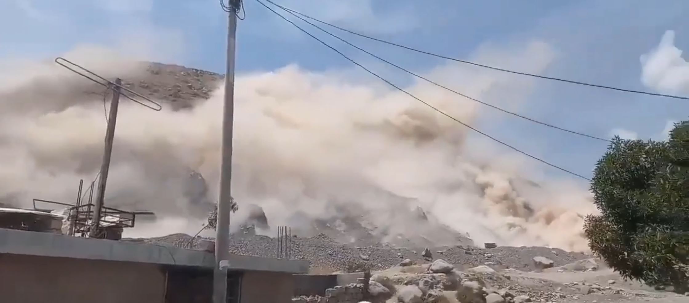
Landslides from the 16 December 2020 M=5.6 earthquake in Peru. Still from a video posted to Youtube.
.
There are some images online of rockfalls triggered by the earthquake, especially on roads, but I have not been able to track down any images of larger failures. These may of course be located in remote areas, if they have occurred.
.
Reference
Barlow, J., Barisin, I., Rosser, N., Petley, D., Densmore, A. and Wright, T. 2015. Seismically-induced mass movements and volumetric fluxes resulting from the 2010 Mw = 7.2 earthquake in the Sierra Cucapah, Mexico, Geomorphology, 230, 138-145. http://dx.doi.org/10.1016/j.geomorph.2014.11.012.
 Dave Petley is the Vice-Chancellor of the University of Hull in the United Kingdom. His blog provides commentary and analysis of landslide events occurring worldwide, including the landslides themselves, latest research, and conferences and meetings.
We need to be cautious of rainfall induced landslide.People should be alarmed and prepared for the upcoming rainfall event. Slopes become less stable after earthquake and propagated cracks will ease water infiltration.
[Yes that is a very good point. You are quite right. D.]
Here are some detail measurement of the earthquake done by Peruvian Geopysical Institute (IGP) – http://intranet.igp.gob.pe/reportes-acelerometricos/20200771.pdf
Hello David,
As always, thank you for your wonderful post!!
I have been using your videos & landslide examples for oh-so many years now (since early 2007) to help teach my Engineering Geology students about the overall risk of landslides, earthquake-induced landslides, slope stability, and how best to address this most significant geologic hazard. And for your contributions, again, I thank you.
In this particular video case, I noticed one detail that has me thinking. And so I would like to present the following open question to this forum.
Where exactly was this video taken? Clearly, the central Arequipa community (as found on Google Earth) is quite flat. According to Wikipedia, there are approximately 1M residents in this region.
The video clearly shows significant hillside topography very near the videographer’s location, so obviously the clip was taken in a hillside community along the outskirts of the city. When looking at the local topography, the site is essentially flat (so obviously, alluvium is present). In the video, right around the 40-second mark, the clip shows a water tower in this flat area. And at the 47 second mark, I also see (radio antenna?) towers; again, in the flat area.
Obviously, the earthquake triggered significant landslides along the steep slopes, but any amplified shaking (due to the lower density alluvium) was not enough to trigger failures in the taller (water tower & antenna) structures.
Is this an obvious case of ridge amplification? (any experienced geo-scientist should be immediately reminded of the 2010 Haiti earthquake and ridge-amplification articles).
My questions are literally endless…
1) was the water tower empty or full? Clearly, that makes a difference.
2) was there an investigation for placement of the radio towers? (I would assume not, but one could only hope).
I could go on and on…
I know I am asking a lot; but does anyone have an estimate on what is the VS30 value in that valley?
We can at least speculate….
Looking forward to input from all.
Dear Ernie,
Once you have located the site, I recommend you contact the following researchers in Peru for geotechnical info: Isabel Bernal (isabel.bernal at igp.gob.pe, Instituto Geofisico del Perú) and Fernando Lázares (f_lazares at uni.edu.pe, CISMID – Universidad Nacional de Ingeniería). They have led many site effects studies in Peru. Here is one example of site effect studies in Arequipa city (IGP 2014, see section 11): https://repositorio.igp.gob.pe/handle/20.500.12816/1327
All the technical reports of IGP are available at https://repositorio.igp.gob.pe/discover and those of CISMID at http://www.cismid.uni.edu.pe/category/informes-tecnicos/ and http://www.cismid.uni.edu.pe/category/publicaciones/ .
Best regards,
Pablo Ampuero – Geoazur – IRD, UCA
https://scholar.google.com/citations?user=RHXdl6EAAAAJ
I think I might have a possible geolocation for the landslides shown in the video. Examining the broader Arequipa area, this looks like the steep rock slopes north-northwest of Apipe neighbourhood. Most of these appear to be abandoned or active quarries. Approximate coordinates 16.321 S 71.558 W. Panoramic views later in the video are probably filmed somewhere north or northeast from the airfield (Caypa?).
These slopes also show evidence of debris disturbance in post-eq satellite imagery (Sentinel-2 December 20).