
25 December 2018
Bureya River: a large landslide but not a meteorite impact in Russia
Posted by Dave Petley
Bureya River: a landslide but not a meteorite impact in Russia
There are reports in various media outlets today about a large landslide on the Bureya River in the remote Khabarovsk region of Russia, which reportedly was triggered by a meteorite impact. The Siberian Times for example has the following report:-
Experts are at odds over the cause of an extraordinary landfall amid reports of hot rocks and extraterrestrial meteorite fragments on a 160 metre-high hill partially now damming the Bureya, a tributary of the Amur River. Some experts believe the phenomenon maybe a landslide but this is disputed especially by those who have visited the remote site, some 1,300 km by road from regional capital Khabarovsk.
Alexey Maslov, the head of Verkhnebureinsky district, said after witnessing the newly formed hill: ‘The riverbed is blocked by a bulk, about 600-to-800 metres wide.
‘The height is from 80 to 160 metres above the ice level. There is no radiation. An object entered at a sharp angle, pulled down a mound and spread it along the river bed. It is not clear what it is: maybe an explosion, a bomb, or a falling airliner.’
This is picked up by for example the Daily Mail:
“A massive landfall in eastern Russia was caused by a meteorite, a falling UFO or a massive bomb, it was claimed today. First pictures from a remote location in Khabarovsk region show how the 390 mile long Bureya River was partially dammed by a monumental rock fall. The top was severed from a large hill with rocks crashing down and forming a new 525 ft-high mound in the river bed.”
The location of the landslide is at: 50.559, 131.472. Satellite imagery suggests that it occurred between 04:49 UT on 11th December and 00:52 UT on 12th December 2018. This is a Planet Labs image of the failed slope and debris pile:-
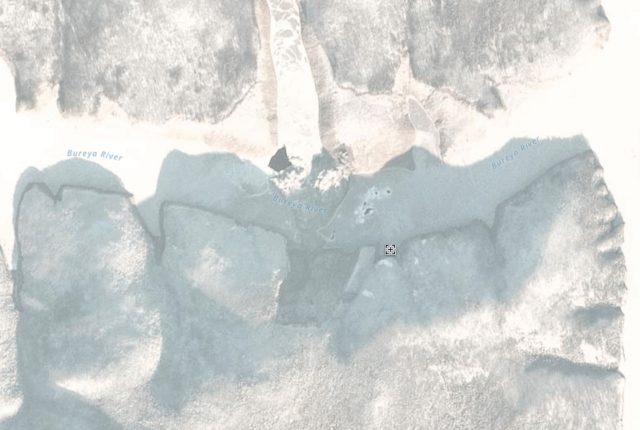
Planet Labs image of the landslide on the Bureya River. PlanetScope Ortho image collected 13th December 2018, used with permission.
.
The landslide appears to be about 500 metres wide and up to about 1.5 km long. It does appear to have blocked the Bureya River, although the debris pile does not appear to be excessively high close to the toe of the failed slope.
This is the slope before the snow arrived – this image was collected by Planet Labs on 19th October 2018:-
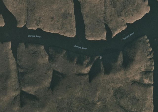
Planet Labs image of the landslide on the Bureya River. PlanetScope Ortho image collected 19th October 2018, used with permission.
.
From this imagery we can say that this is certainly a rockslope failure, and that it is highly unlikely to be associated with a meteor impact event. The slope appears to show a pre-existing tension crack or depression that aligns with the rear of the failed mass. This is at an elevation of about 580 m, the valley floor is at about 190 m.
This makes sense in light of the YouTube video from the Siberian Times article, which appears to show a conventional rock slope failure:-
.
The best understanding of the landslide comes from this still from the video:-
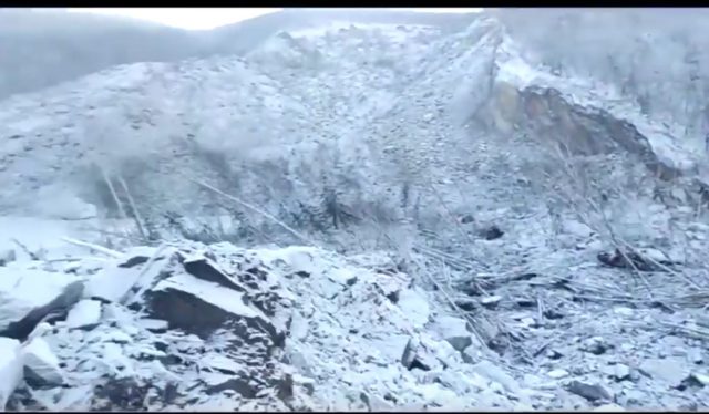
The source of the Bureya River landslide. Still from a Youtube video
It is a spectacular rock slope failure, with a quite mobile component. The speculation of a meteor event is incorrect. The slightly only surprising aspect is the timing – in cold areas rock slope failures mostly (but not exclusively) occur in the warmer months. An interesting aspect though is whether the depression to the west of the rear scarp is another extensional feature? If so there may be a larger failure yet to come.
Reference
Planet Team (2018). Planet Application Program Interface: In Space for Life on Earth. San Francisco, CA.
 Dave Petley is the Vice-Chancellor of the University of Hull in the United Kingdom. His blog provides commentary and analysis of landslide events occurring worldwide, including the landslides themselves, latest research, and conferences and meetings.
According to the weather records from the nearest settlements available at https://www.gismeteo.ru/diary/, on December 3 there was a significant warming (from -20 to -3 C), and after that – a sighificunt cooling – up to -33-34 in the night time. May be rapid freesing of water in the fractures could trigger rock slope failure.
As I was informed by Mr. Nikilai Kharitonov – the former head of the seismological survey of the Bureya HPP, o local eahquake that could trigger it have been recorded. But landslide failure itself was recorded by local seismic network installed to monitor induced seismicity. The nearest station is about 80 km from the site.
I also note the big runup zone on the north side of the reservoir.
Looks like the reservoir started filling in earnest in 2003, extending east to this location as evidenced by the water level advancing up adjacent tributaries – an apparent highstand occurs around 2010. A drawdown “bathtub ring” is visible in the latest photo. Maybe this was induced by filling to maximum, then a drawdown event.
https://www.facebook.com/photo.php?fbid=1980950565307801&set=gm.1975569782542190&type=3&eid=ARBpb5APA_4BR6feains9BgXzZvOdAjMfQUE0MJYZYFOqyTzzyuPmCtAJQDPzc4shAbXBsNM4Sr0DUez&ifg=1
Information is scarce even in Russian, but many outlets reported that Russian president ordered the military to be ready to blast the new dam that blocks 28% of reservoir volume.
“Following instructions from Russian President Vladimir Putin, the Ministry of Defense joined forces to clean up the bed of the Bureya River, which was blocked by a collapsed hill. ” https://tech2.org/russia/cleaning-the-dam-on-the-bureya-river-will-take-military-service-declarations/
Local scientists already expressed a concern that blasting the dam may trigger another landslide.
An expedition from academia is working in the area now in parallel with military camp being set nearby…
The only agency not releasing any information is the Rushydro Company the owner of Bureya reservoir, drawdown of which probably facilitated the landslide….
Thanks immensely for this article. The mainstream media are sensationalizing this event with a “UFO crash” story. This analysis brings some common sense back into the picture!
Blasting started at Bureya Reservoir lanslide site
http://www.transrivers.org/2019/2544/
Historical weather – https://world-weather.ru/pogoda/russia/khabarovsk/december-2018/