
17 January 2018
The fascinating Rattlesnake Hills landslide in Washington State
Posted by Dave Petley
The fascinating Rattlesnake Hills landslide in Washington State
In Washington State the Rattlesnake Hills landslide continues to develop under conditions of close scrutiny from the media. The Washington Department of Natural Resources (WA DNR) has a website dedicated to the problem, which includes the following schematic map of the monitoring that is being undertaken and the broad patterns of movement:
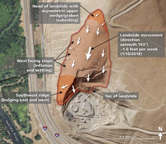
WA DNR schematic map of movement patterns for the Rattlesnake Hills landslide.
.
The map indicates a highly complex landslide with what I would consider to be an unusual movement pattern, with displacement apparently approximately parallel to the ridgeline. This is probably associated with the underlying geological structure, WA DNR interpret it as sliding on a silty layer between fractured basalts, dipping at about 15° into the quarry. This of course asks questions about how the quarry was permitted in such geological setting (on the face of it, the setting as described by WA DNR appears to be quite prone to instability), but that is a different issue.
WA DNR have extensive monitoring on the slope, including GPS monitoring sites, prisms for total stations, ground-based LIDAR and of course mapping of the slope. This is a good combination, and the authorities have retained the skills of a number of specialists. If find the drone images of the tension cracks very interesting – this video was published on Youtube on 13th January:-
.
Particularly interesting is the comparison between the deformation on the east and west flanks of the landslide:-
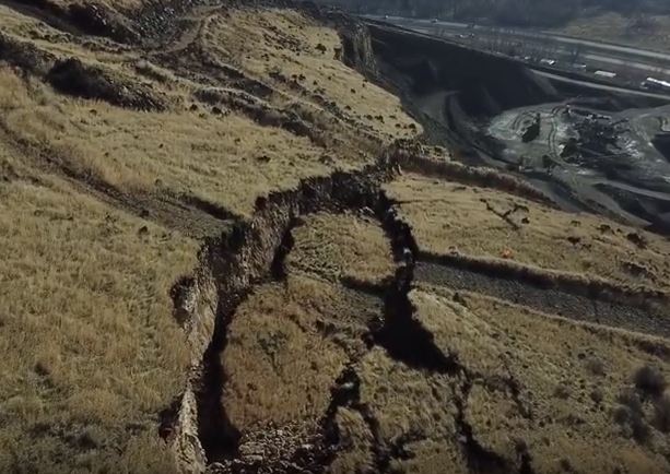
Deformation on the east flank of the Rattlesnake Hills landslide, via a Youtube drone video
.
Meanwhile on the west side the deformation is quite different, with limited ground cracking and some bulging:-
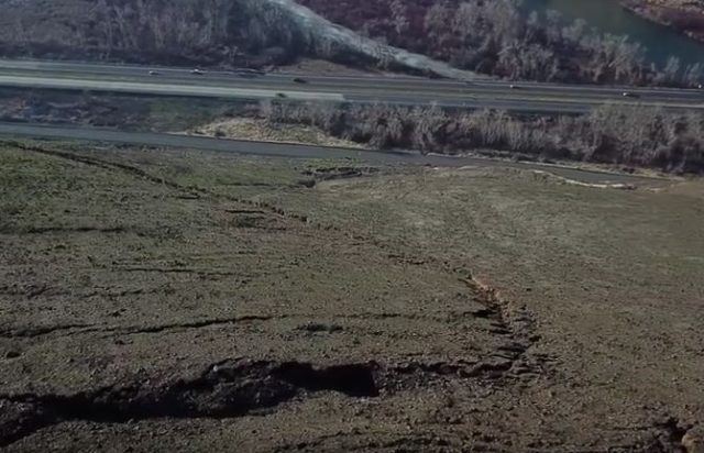
Deformation on the west side of the Rattlesnake Hills landslide, via a Youtube drone video.
.
This suggests a highly complex movement pattern that is hard to interpret without proper data (which WA DNR are collecting). I can understand why the authorities are being so cautious about predicting the time of final collapse. This one will be interesting to observe over the coming weeks.
 Dave Petley is the Vice-Chancellor of the University of Hull in the United Kingdom. His blog provides commentary and analysis of landslide events occurring worldwide, including the landslides themselves, latest research, and conferences and meetings.
Thanks for the information. Saw the same thing happening year after year for decades along the coastal area of Monterey County, California and known as Big Sur. Hope these folks up in Washington realize the potential for a very dangerous and massive movement at ANY given moment. Noted is the fact that the two areas may not be caused by exactly the very same conditions, the end result will be the same. Potentially, lives could be lost and a massive undertaking/rebuild/repair would certainly follow. Thanks again for the info. Gordon Sonne’
Well noted Gordon ….the spring of 2017 was very tough on the Big Sur area. Communities up and down the coast, and the State itself were burdened by economic, and resources loss and limitations. Caltrans worked with us (IDS GeoRadar) to deploy and monitor 4 sites with our IBIS radar interferometers. Every 2-4 minutes differential velocity, displacement, and inverse velocity plots were available that allowed work to continue — while the slides remained ACTIVE .. Safely, and on time (mitigation projects) schedules were met.
We have offered a similar capacity in WA, but so far have been met with lack of interest — or AWARENESS of the good that can be done with the best instruments and coordination of data with site professionals.
ACTION when these events unfold … amounts to many millions of dollars, and irrecoverable hours, that can be leveraged positively … when allowed to do so …