10 November 2017
The Mocoa debris flow disaster: satellite imagery reveals the cause
Posted by Dave Petley
The Mocoa debris flow disaster: satellite imagery reveals the cause
The Mocoa debris flow disaster, which occurred in Colombia on 1st April 2017, is believed to have killed 399 people, and left a further 329 people injured. Triggered by heavy rainfall, the debris flow swept through the town at 3 am. I discussed the landslide at the time, and speculated on possible causes, but at that stage it was hard to know what had happened upstream of the town to cause the disaster. In May GFZ Potsdam provided an initial analysis of satellite images of the site.
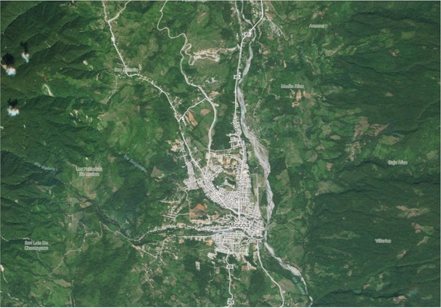
Seven months on there is an archive of satellite imagery of the area available. This is not an easy place to image because of the high prevalence of cloudy conditions in the mountains, but in the PlanetLabs archive it is now possible to find before and after images. This is a RapidEye Ortho image, with 5 m resolution, collected before the disaster on 22nd November 2017:-

Rapideye Ortho image of the Mocoa area, collected on 22 November 2016, via PlanetLabs.
.
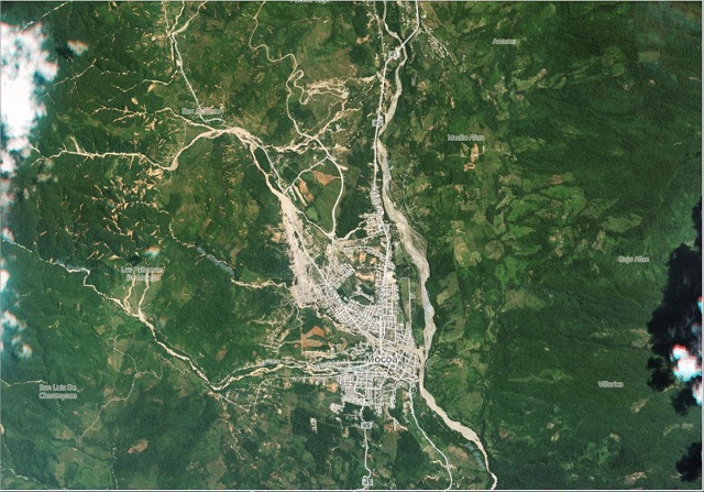
This is a further RapidEye Ortho image of the same area, collected on 10th April 2017, nine days after the disaster:

RapidEye ortho image of the Mocoa debris flow disaster collected on 10th April 2017, via PlanetLabs
.
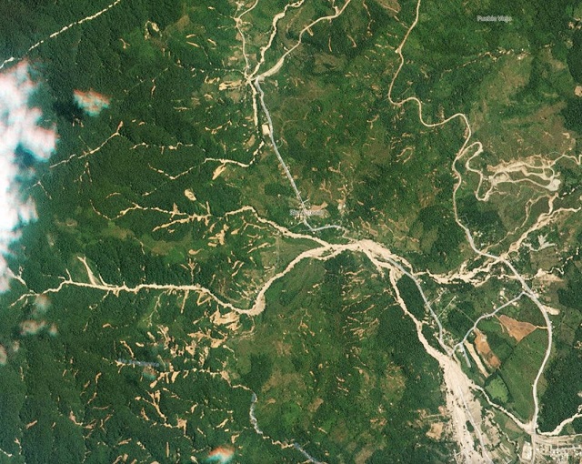
The aftermath of the disaster is clear, with extensive destruction to the western part of the town. To the west and northwest of the town very large numbers of landslide are visible. It is worth taking a look at that area in a little more detail – this is a zoomed in version of the image from 10th April showing the area to the immediate northwest of the town, which can just be seen in the bottom right hand corner:-

The aftermath of the Mocoa debris flow disaster. RapidEye Ortho image collected on 10th April 2017 via PlanetLabs
.
It is clear that upstream of the town the rainfall triggered hundreds of small, shallow landslides on the eastern-facing slopes. Most of these landslides connected directly into the channels, and thus almost simultaneously would have fed debris into the drainage system. It is this water and debris, that combined to create the catastrophic debris flow that destroyed the town.
A really interesting aspect of this is that it appears that this may have been generated by a very isolated, presumably extremely intense rainfall event. As the secon image above shows, the slopes to the east of the town did not undergo intense landsliding. This is also true of the slopes to the southwest of Mocoa (as the second image shows). Indeed the area of very intense landslides is no more than 10 km from north to south and 3 km from eat to west. Mocoa was incredibly unfortunate to lie downstream of this area of rainfall and resultant landslides.
Reference
Planet Team (2017). Planet Application Program Interface: In Space for Life on Earth. San Francisco, CA. https://api.planet.com


 Dave Petley is the Vice-Chancellor of the University of Hull in the United Kingdom. His blog provides commentary and analysis of landslide events occurring worldwide, including the landslides themselves, latest research, and conferences and meetings.
date at end of 2 nd paragraph is wrongly given as Nov 2017; it is correctly attributed in the text accompanying the image below.