
23 July 2015
Ambunti, Papua New Guinea: an interesting riverbank landslide
Posted by Dave Petley
Ambunti, Papua New Guinea
Via Twitter, Dr Phil Collins of Brunel University (@PhilCollins_UK) highlighted an interesting story on an Australian news website about a “sinkhole” that developed on Saturday on the banks of the Sepik River in Ambunti, Papua New Guinea. The original news report has some images:
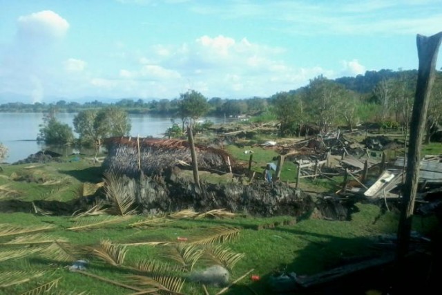
Ambunti landslide via ABC News and Jamie Asa
.
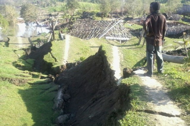
Ambunti landslide via ABC News and Jamie Asa
.
Pacific Islands Report has a longer description of the landslide:
According to witnesses Jamie Asa and Frank Warakai, the sinkhole formed about midday last Saturday at the Forex Camp and Saksak Compound, along the Sepik River. “Sixteen houses went down as the earth opened up unexpectedly.
“The settlers panicked and scrambled out of their houses within minutes as the earth shook,” a shocked Warakai said, adding that his house was the first one to be sucked in by the sinkhole.
He said he was woken from his sleep by the movement of the earth and jumped out of his house. As he ran for safety, the earth gave way within seconds, causing a large stretch of land to immediately sink in, creating huge cracks that destroyed houses. Mr Asa said the people in the settlements also panicked and many managed to escape to higher grounds. He said the displaced people are seeking shelter in makeshift houses and at nearby villages.
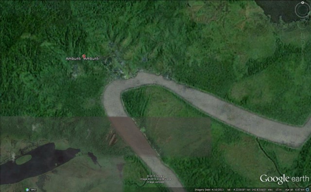
Whilst this is being reported as a sinkhole, I am certain that this is a riverbank landslide. Unfortunately the Google Earth imagery for this location does not have a high resolution, but Ambunti appears to be on the outside of a sharp river bend, and there is a feature sticking into the river on the apex of the bend that looks suspiciously like an old landslide, but that is pure speculation at this stage:
Google Earth
.
 Dave Petley is the Vice-Chancellor of the University of Hull in the United Kingdom. His blog provides commentary and analysis of landslide events occurring worldwide, including the landslides themselves, latest research, and conferences and meetings.
Several maps suggest Amburti is within the river’s horseshoe and not where “Amburti Amburti” is indicated on the Google Earth image you show. Enlarging the image at http://mapcarta.com/16547544 shows there is much higher resolution in the brown-hued section. This shows many buildings (a few with ‘white’ roofs) were built along the west bank of the river, and very few on the east bank. I don’t doubt the river is lined with settlement(s) where the river appears to be bound by a green hedge. (Looks like landslide debris on the north side of the river bend to me too.)
I happen to have lived in Ambunti, ESP between the years of 1984 and 2002. The main town is in fact located on the north side as the google pin indicates (the opposite side is also populated although rather sparsely compared to Ambunti). The area where the river landslide occurred (Western-most portion of the town along the north shore of the river) was a low-lying area which was heavily populated and had poor drainage. In addition, that section of the bend takes the full force of the river as it turns and constricts. As to the supposed former landslide that is unlikely due to the topography of that location: the long green stretch extending Northwest is actually the grass airstrip, this site was chosen because it was a very level portion of the valley to begin with. That bulge into the river, is caused by a large rock outcropping which protects that area and causes massive turbulence reaching as far out as half way across. This diversion of the river actually causes the river to flow backwards along that bulge during most times of the year, a phenomenon known as “bakwara” or “back water” by the locals.