6 January 2015
The Scorciavacche Viaduct in Sicily: an earthworks failure that has become a national scandal
Posted by Dave Petley
The Scorciavacche Viaduct in Sicily
In Italy there is something of a scandal developing around the newly completed Scorciavacche Viaduct, a new (very impressive) elevated highway not far from Palermo. The road opened a couple of days before Christmas, but has now had to be closed again because of the collapse of a section built on an embankment. The story has attracted considerable attention from the international media, who are generally describing the problem as “subsidence”.
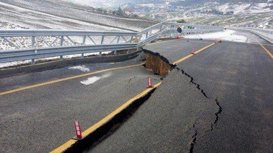
The best images that I can find of the site are on the Repubblica website (text in Italian), which has an excellent portfolio. This includes a good picture of the roadway – it’s not hard to see why the highway has been closed:
.
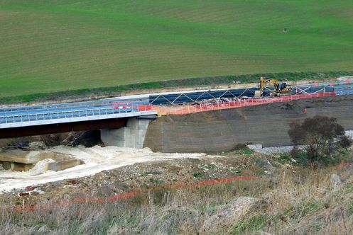
The problem appears to be the failure of a set of remarkably steep earthworks alongside one of the bridge abutments (the abutment itself seems to be intact):
.
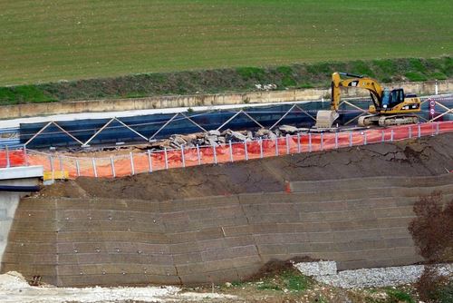
A closer view of the problem gives a better indication of the problem:
.
The failure seems to have affected quite long section of the embankment:
.
This is clearly an earthworks failure – i.e. a landslide in the embankment. I am not really familiar with the construction technique here – others ate probably better placed to comment. The embankment seems to be founded on gabians. Above this is some sort of slope protection covering a steep earth bank. Close to the abutment (see the second picture) this might be soil nailed (comments – experts have subsequently suggested that these are not likely to be soil nails, it is not clear what these objects are), but this doesn’t seem to be the case for most of the embankment. The major failure seems to be in the first section without the soil nails, which is showing distress directly above the base of the embankment. Further to the right the failure is more complex and difficult to understand.
This case is now subject to formal investigation by an Italian magistrate, so hopefully the cause will become apparent soon. It will be very interesting to see what emerges. In the meantime, I’d welcome comments from those who know about embankments.


 Dave Petley is the Vice-Chancellor of the University of Hull in the United Kingdom. His blog provides commentary and analysis of landslide events occurring worldwide, including the landslides themselves, latest research, and conferences and meetings.
Interesting. The gabions appear to be in front of and at the base of the embankment and are presumably there to provide some scour protection at the base of the embankment.
The facing on the lower part of the embankment slope is more difficult to pin-down (pun intended). I can see why people might think that the ‘points’ are soil nails, but they appear to be to more widely spaced than one might expect, especially vertically. The facing looks like a bio-mattress intended to promote vegetation growth and I wonder if the embankment might have been constructed using a pre-formed shuttering/reinforcement system – the ‘points’ might then be holding-down pins of some sort or, indeed, soil nails. And the fact that the ‘points’ stop some way back from the abutment does point to them being soil nails.
What I do not understand is why the facing stops some way from the top.
This is of course all pure conjecture and made from a viewing of few rather low resolution photographs.
It will be interesting to learn what the design and construction philosophy was and why this embankment failed.
Theories: Most likely poor compaction.
1) Fill installed too dry, or not enough compactive effort.
2) Dry/loose fill hydrocompacted when it got wet this winter.
Need a good side shot down the face of the embankment to see how steep it really is. Tough to tell if that’s a bulge in the face, or misaligned facing panels.
Doesn’t look like the hillside beyond is affected.
[Agreed. This is a landscape that is clearly very landslide prone, but the failure appears to be in the embankment only. D]
Apart from the vertical component the facing doesn’t seem to have displaced too much; I’d guess its probably reinforced earth from the apparent steepness, regular horizontal layering and termination before the crest? The abutment hasn’t shifted either so is likely founded below any movement.
From the lumpy terrain and sidelong ground my guess would be a simple foundation failure, possibly on a pre-existing landslide surface or on low strength material such as colluvium / alluvium. The political outcry is interesting to see (from a distance!)
[Indeed – this article (in Italian) suggests that the builders also believe that its a bearing capacity failure. A rough translation of the key section is:
“The engineer, Pier Francesco Paglini, head of CMC in Sicily, claims that there may have been an erroneous assessment of the load-bearing capacity of the foundation soil.”
D]
How does the surface paint control the trace of the fault? There is an even better example in your earlier blog here: https://blogs.agu.org/landslideblog/2013/02/22/the-bitter-springs-landslide-in-arizona-usa/ where the fault trace clearly ramps from one line to another.
Likely the paint runs along the joint between adjacent strips of asphalt, which will be a weakness within the road surface. http://s3.freefoto.com/images/21/62/21_62_26_web.jpg