
2 April 2014
The Oso (Steelhead) landslide in Washington State – could it have been foreseen?
Posted by Dave Petley
The Oso (Steelhead) landslide in Washington
The best news about the Washington landslide is that, as forecast, the number of victims is likely to be rather lower than was feared at one stage (I noted earlier that this might well be the case). The official toll has now reached 28 people known to have been killed, with a further 22 remaining missing. To have recovered 28 bodies to date is an impressive achievement, and this will have been deeply traumatic for those involved in the search and rescue operations.
So now attention, in the media at least, is focused on whether the landslide could have been foreseen. Opinion on the internet varies greatly (no surprises there!), ranging from the view that the risk was tolerably low to the view that it was completely foreseeable. I’ll nail my colours to the mast – to my mind this was foreseeable event, and as such the disaster represents a failure of hazard management.
Using the past as a guide to the future
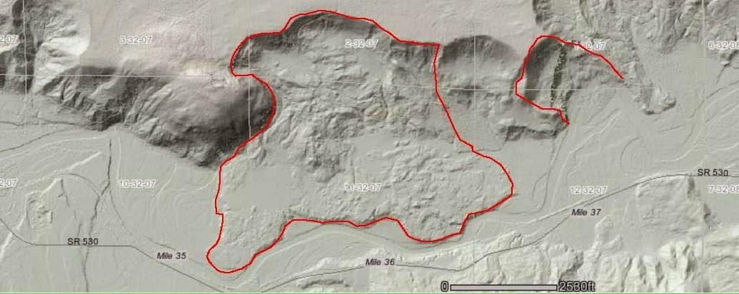
The simplest way to understand the likely future behaviour of a landslide is to examine how similar landslides have behaved in the past. In the case of the Steelhead landslide, this was very simple. Immediately to the west of the landslide there is another large failure. This landslide is very obvious on the LIDAR imagery. Dan McShane provided an analysis of the Steelhead landslide history from Google Earth images within a day or so of the slide event, and included LIDAR imagery (from before the most recent movement of the Steelhead landslide) that showed this other failure to the west:
..
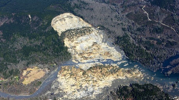
In this image the Steelhead landslide is highlighted on the right, and this much larger landslide is highlighted in the centre of the image. Note that there is another landslide scar between these two landslides. The key aspect of this larger landslide is the extensive area that the debris has covered. And look at the morphology of the deposit as shown in the imagery, and in particular the structure of the material that has flowed onto the valley floor, as shown in this BBC/AP image:
..
So this bluff has a long history of landslides, and the evidence on the ground suggests that they can be very mobile. Note also from the LIDAR imagery the shape of the land above the old Steelhead landslide scar – this promontory does not look like a stable configuration in such a weak deposit.
The defence of the emergency planners (as reported by Andrew Alden) in Washington seems to be that after the 2001 movement event at Steelhead the landslide was mitigated by protecting the toe from erosion by the river. There is little doubt that a large amount of work was undertaken in this respect. This is a Google Earth image of the foot of the landslide in 2003:
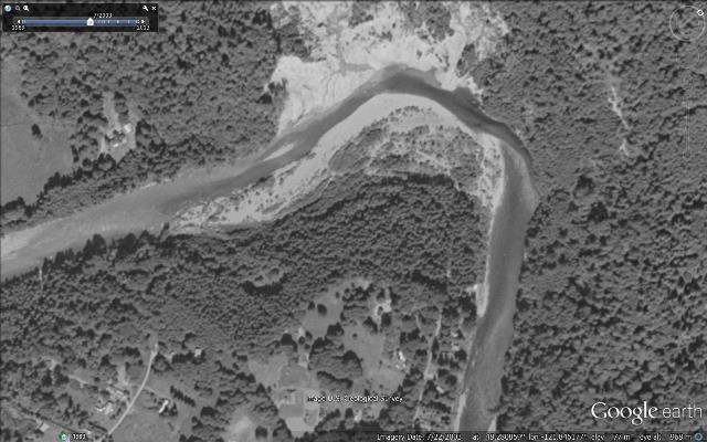
…
And this is the same view in 2007:
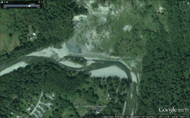
..
Clearly the river was relocated and the toe of the landslide was protected. Note the houses that are visible in the second image that were not there in 2003. However, for these very large landslides it is likely that the failure is driven by groundwater driven processes in the upper part of the slope. Protecting the toe will have done little to prevent this from occurring. Thus, the mitigation did not address the primary concern.
The 2001 landslide left material high on the hillside that was sitting above a scar that was far too steep (see the image in this post). The LIDAR data suggests that the runout from such a collapse could be extensive. In that context I find the decision to build new houses at the foot of the landslide to be very surprising.
 Dave Petley is the Vice-Chancellor of the University of Hull in the United Kingdom. His blog provides commentary and analysis of landslide events occurring worldwide, including the landslides themselves, latest research, and conferences and meetings.
I believe this is a fair interpretation. It is sad that no terrestrial InSAR was acquired in any of the most current events, or as a seasonal review ..clearly there are issues in communication and education between scientists, planners, officials, and citizens ….still in 2014 ..
I am making an effort to do some scanning of the headwall, and perhaps allied areas .. noted in your information …there is a likely integration of the two slide features … overtime.
There are numerous areas of risk like this across the USA … near Provo, Utah (2 killed a few months ago), Interstate 70 at Glenwood Canyon/Hanging Lake (millions in repair/mitigation) ..yet we roll on, build on …thanks much for your insight and information, I have shared it across my network .. excellent work.
Remarkable LIDAR. The large runouts of these slides on low gradients suggest the presence of quick clay or somesuch in the sedimentary stack. Once the material fails, it behaves as a viscous fluid, IIRC. These remind me of slides commonly seen in the Leda Clay of Quebec, and another large slide in Norway in the late 1970’s(?) that was used as an example when I was in college.
Google Earth image July 2013 https://www.google.com/maps/place/Oso,+WA/@48.2826061,-121.8445289,6097m/data=!3m1!1e3!4m2!3m1!1s0x54853788978dc709:0xd1f04d517f367e50
A slide on this exact site in 2001. Another in January 2006. The slope could still be seen in pre-slide images to have an open wound giving rain water access to the interior of the slope. It was not a matter of if this hillside would slide again, but when. The question is: how many other locations are similarly demonstrably unstable? Will we be surprised when these other hillsides collapse?
You are all welcome to explore and/or download the Oso Landslide GIS Geologic database I generated last week from public data viewable on Google Earth on my website.
http://www.geological-assessments.com/Oso_Landslide.html [link corrected – D]
The other web pages also contain more fascinating original GIS databases by me. If I get enough interest I may post my blog address for the 2011 Adirondack NY landslide as a reward.
The questioning of responsibility should not be intended to point a finger during this time of private and public shame and despair, but to encourage others to explore the multi-faceted shared responsibility we all have in terms of local, state and federal public and private entities as well as private and public landowners and citizens. The lack of interest or concern for spatial, geologic and environmental knowledge by many is a problem as well as the pressure for short term profit for the few that may supercede practical concerns for safety and long term profit and prosperity for communities. Before we can develop for the future, we must look at the past to envision our communities beyond the present. One way to do this is to value and utilize historic topographic maps and historic aerial photographs.
E. Martinez, April 5, 2014 at:
http://community.seattletimes.nwsource.com/reader_feedback/public/display.php?source_id=2023288058&source_name=mbase
To view my documentation of the 2011 landslide in Keene Valley, NY, visit http://erosion2011.blogspot.com/p/blog-page.html
After the landslide happened, I opened Google Earth to the location, and saw the Before picture as an unmaintained wall, with logs lying askew, allowing the force of the North Fork of the Stillaguamish River to jet into to the unprotected hillside.
I would point MY finger at whichever Department deals with maintaining the once-built and disheveled log wall that I saw on Google Earth.