
1 September 2010
The latest NASA image of Attabad
Posted by Dave Petley
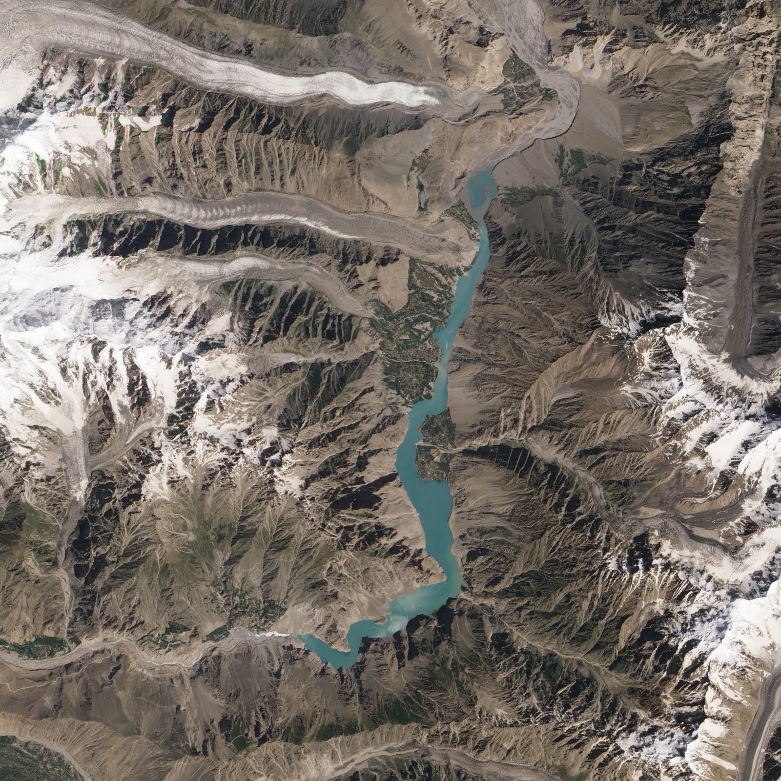
NASA have released another spectacular satellite image of the Attabad dam and lake. In the article they focus on the upstream end of the lake:

The article states that the water level can be seen to have dropped as the area upstream of Hussaini is no longer inundated. Now there is some evidence that the water level has dropped a little – the Pamir Times reports 12 feet (4 metres), although this may well be a downslope distance rather than a vertical fall. As inflow decreases the water level should decline until the outflow balances this amount. The Pamir Times article above also alludes to operations on the spillway, though it is unclear as to whether these have actually started. I think that it is more likely that the apparent drop in the imagery is actually due to sedimentation in the river channel. This is supported by a close look at Hassaini itself, which shows no signs of a drop in water level.
To me the most interesting aspect of this new image lies in the main part of the lake:
This is a comparison of the two most recent images of the landslide scar, dam and spillway area. The first was collected on 7th July. Note that it is partially obscured by dust:
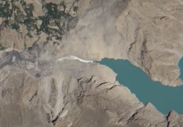
Whilst the second is the most recent image, collected on 23rd August:
The key thing to note is that the spillway has evolved considerably – it has widened and become more sinuous. There is also some apparent change in the water flow upstream end of the channel, which appears to be more turbulent now. This could be due to a change in the volume of flow. Finally, note that there also appears to be a couple of dust clouds in the upper part of the scarp area, suggesting that this is still evolving.
All of this means that system has not yet reached an equilibrium state, and thus remains a threat. Fortunately though as winter approaches the risk of a rapid collapse is reducing, although unfortunately not to residual levels.
 Dave Petley is the Vice-Chancellor of the University of Hull in the United Kingdom. His blog provides commentary and analysis of landslide events occurring worldwide, including the landslides themselves, latest research, and conferences and meetings.
Hi,I follow your blog since the landslide in Attabad.I was in Pakistan this summer and went in Gojal-Hunza just during the floods. Landslides at the place of the dam were very frequent at this period.You can see some pictures of this here if you want :Gallery AttabadI hope the best for the friendly people of Pakistan.Guillaume
If you take a look at the mointain structure north of the dam you will recognize, that still huge landslides have happened there between the two pictures. The mass has dropped into the lake near to the dam, so the lower end of the lake has become thinner. I guess these masses also have an influence on the turbulences in the upper part of the spillway!Maybe one or another day in the recent weeks these further landslide caused the unexpected rising of the lake level!?
Around Hussaini, the riverbed is surrounded by very steep slopes, so I highly doubt you would be able to identify a 4m vertical drop of the water level from an aerial image.Upstream of Hussaini, the NASA August picture looks quite comparable to the (old) Google maps image. I think it can be concluded that the river level really did drop and receded as shown.
A very nice 9+ minute video of the Attabad spillway taken on Aug 6. If not at peak flows, perhaps very close.I think this is new to youtube.It's worth your time to set the viewer to 480p. Note the vehicles to give scale to the water flows.
Thanks so much for the Attabad info, Dave.
Superb pictures and slide show, Guillaume. And the most recent video of the spillway is very well made too. Thanks.Special note to Dave: I'm gettint a warning that the certificate of security is off when clicking to post a comment. Did you know this?Brigitte