31 August 2010
Catching up – recent landslide events
Posted by Dave Petley
The next few posts will be an attempt to catch up on the things that I missed whilst on vacation in Switzerland last week. Thanks to the many people who have tipped me off about landslide events. I will cover Pakistan in another post.
1. A large flow in Austria
Thanks to Martin Springer for highlighting this one. On Saturday 21st August a severe storm triggered a 100,000 cubic metre flow in the Karwendel Nature Reserve. Fortunately no-one was killed, but a dozen cars are trapped in a car park. It will take two months to clear the debris. There is a short video of the deposit and further details about the landslide (in German) here.
Read more by clicking below:
2. The power of a mudflow illustrated by an articulated truck in California
Thanks to Lisa Denke for this one. A large storm in eastern California on Thursday last week triggered a mudflow in the Owens Valley in eastern California. An articulated truck (known as a tractor trailer in the US) was caught in the path. There is a short but useful video of the event in this news report:
http://content.secondspace.com/news/detailsplayer.swf?videoSrc=http://kidkbim.s3.amazonaws.com/floodtru-1282928772.1.mar.mp4&prerollAdTag=http://ad.doubleclick.net/pfadx/KBAK/LOCAL;tile=1;sz=320×240;ord=17211858&clickURL=http%3A//www.bakersfieldnow.com/home/video/101657338.html&startPlaying=false
3.An excavator in Gilgit-Baltistan
Accompanying the video above is an extraordinary image of the aftermath of the rains in Pakistan, courtesy of the Pamir Times:
I am reminded of the old “how does the driver of a snowplough get to work?” line.
4. Devastating landslides in Turkey
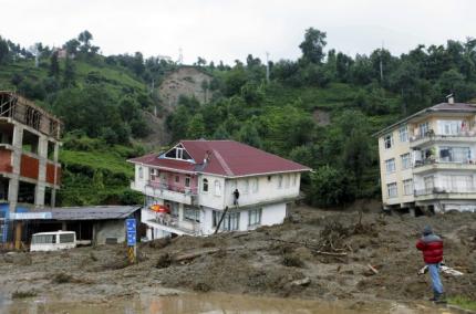
Also on Thursday last week, heavy rainfall triggered landslides in the town of Gundogdu, in Rize Province in Turkey, killing 12 people. The image below is taken from this news report:
5. The typhoon season has now got started
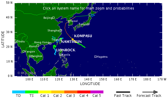
Finally, the very slow start to the Pacific typhoon season has now come to an end, with a series of storms developing at the moment. The three storms currently active all have the potential to cause landslides (image from Tropical Storm Risk):
Lionrock and Namthuen could both bring very heavy rainfall to southern China as they track inland over the next couple of days. Meanwhile, the forecast track of Typhoon Kompasu suggests that this very intense typhoon could bring substantial amounts of rainfall to the Korean peninsular. North Korean in particular is very vulnerable to the effects of heavy rainfall due to the extensive deforestation endemic in that country. The potential impacts of this storm are serious, although note that there is considerable uncertainty in track forecasts.


 Dave Petley is the Vice-Chancellor of the University of Hull in the United Kingdom. His blog provides commentary and analysis of landslide events occurring worldwide, including the landslides themselves, latest research, and conferences and meetings.
The Attabad lake level is falling.Nasa's Earth Observatory has a comparison of images taken a week apart of the head end of the lake.
I thought you might be interested in this article. NASA Images Show Anatomy of Pakistan Flood Disaster The full version of this story with accompanying images is at: http://www.jpl.nasa.gov/news/news.cfm?release=2010-274&cid;=release_2010-274
Maybe this website in China interests you:http://news.ku6.com/c2010/8154/nishiliu/(use the Google toolbar translator like I do… ;)[email protected]