2 June 2010
Attabad – so why hasn’t it breached yet?
Posted by Dave Petley
Several people have emailed to ask why the lake has yet to breach. Well, I would like to emphasise two things – first, that every landslide is different, so predicting the behaviour of any particular slide is effectively impossible. Second, there is a peculiarity about the spillway that appears to be delaying the breach event.
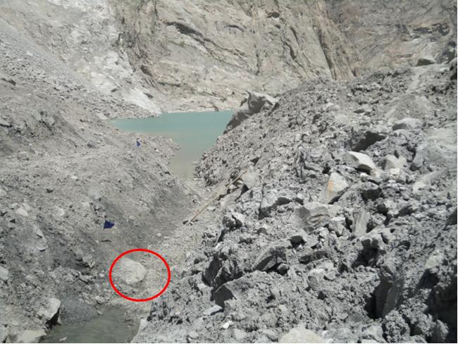
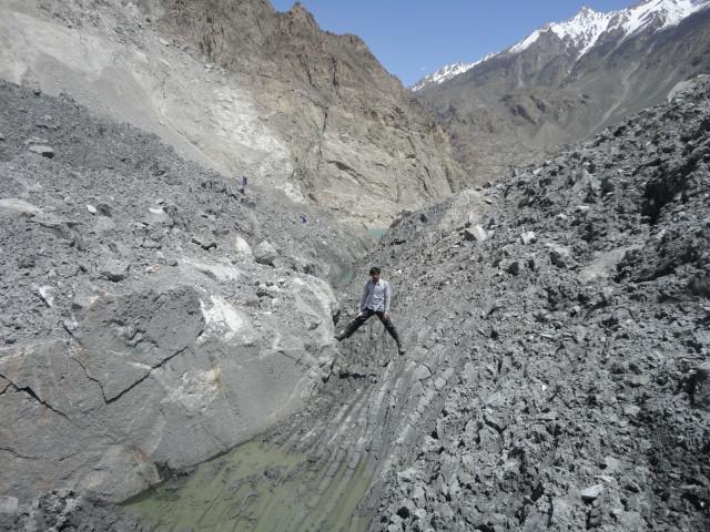
Regular readers (of which there are now several thousand each day I think – thanks to you all) may remember that a few days ago I noted the presence of a large boulder in the channel, right at the crown of the spillway:
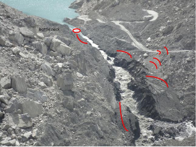
Well it is this boulder that is preventing the scour from propagating upstream and that is, in effect, protecting the upper part of the channel against further erosion, as this image shows. The boulder is circled:
The lower part of the channel is continuing to erode with some power, and the channel is widening. The red lines show substantial cracks suggesting further potential widening. The steepest part of the channel is continuing to erode backwards, such that sooner or later the boulder will start to be undercut.
Meanwhile, there appears to be an increasing level of frustration about the very confused spillway discharge statistics emerging from NDMA. This is understandable. If we take the last four daily reports we get:
29th May 18:00: 150 cusecs (cubic feet per second) from the spillway, 350 total discharge
30th May 18:00: 900 cusecs total discharge
31st May 18:00: 900 cusecs total discharge
1st June: 18:00: 1050 cusecs discharge at Ganesh Bridge.
This is a quite bizarre mixture of measurements, but we should all understand that the NDMA team dealing with this are under huge pressure too.
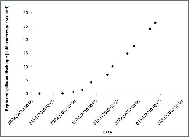
Meanwhile, the more reliable measurements of inflow suggest that the rate is continuing to increase linearly with time, probably because of the choke provided by that boulder. However, I am very surprised by just how linear this increase is proving to be, so please treat this with some caution:
The lake level upstream continues to rise, increasing both the damage and the amount of water in the lake. In the last 24 hours the lake level rose by 75 cm, perhaps suggesting that the rate of inflow is further increasing.
Finally, several people have emailed to ask why I have not covered the multiple landslide accidents around the world in the last few days, including the multiple slides in Central America (and that amazing sinkhole), the landslides in China, the non-fatal slide in New Zealand, etc. I will try to catch up on all of those things as and when this event ends – please accept my apologies. You will understand that I have to maintain my day job whilst doing this, plus yesterday and today I am moving house!


 Dave Petley is the Vice-Chancellor of the University of Hull in the United Kingdom. His blog provides commentary and analysis of landslide events occurring worldwide, including the landslides themselves, latest research, and conferences and meetings.
The rising lake level means that at some time the water could be descending with increasing force on whatever is downstream and below the bottleneck boulder. What happens next will depend on what the boulder sits on. If bigger stable boulders, we may see widening of the spillway with of course more rapid erosion of any less resistant material that becomes exposed to the stream flow. If the material below the boulder is erodable, the boulder could roll/slide downstream and the channel could rapidly erode the remaining distance to the lake with a high rate of flow increase. Whether that happens before retrogressive erosion undermines the bottleneck boulder is a bit of a race.George
Good luck moving and thanks for all your hard work!
Excellent information and commentary as usual.I note from yesterday's photo that there is an area of white water downstream of the area circled as the bottleneck, whereas at the location shown the channel is quite wide and the water flow looks smooth. I also wonder if the boulders shown in the two photos are the same. Difficult to be sure despite the excellent quality of the photos. The material beneath the second boulder looks quite cohesive as shown by the imprint of the teeth of the excavator. This would presumably be harder to erode.If the lower location is the bottleneck, then this brings it closer to the active area of erosion increasing the risk of undermining of the boulder.As stated previously, measuring the discharge from the spillway must be very difficult, but if the data is reasonably correct, the outflow needs to increase substantially before the lake inflow is balanced.
I would sure like to see today's picture, bigger and without the red lines.The large rock that leads the right side of the spillway looks like it will be an island soon. The lake is rising enough to make that boulder moot. I would not be surprised if the channel shifts to right before that boulder is undercut.
Dave,Thanks so much for all the updates about this event. Here in New Zealand we hear absolutely no other news about this and I've followed your updates with great interest.And to all those affected, my thoughts and prayers are with you.Kind regardsPhil
Those large boulders have always been of particular interest, at least to myself…
1 What is nature of former river slopes?2 What is nature of slide material?Why so many apparent terraces in photos of the downstream areas?Suggest that slide debris is poorly sorted varying from rock flour silt with some clay from weathered to disintegrated rock to intact rock seams fractured during the slide.Former channel deposits likely consist of larger cobbles, boulder and stone sizes with sand and gravel infill or open voided honeycomb structure. As levels within the impoundment area rise either progressive piping and collapse of the former river banks and/or differential head are increasing the seepage portion of the flow. It may be that the flow paths are long enough that the slide is initially stable against piping and stability failure. Down cutting of the softer erodible materials in the excavated spillway (was the spoil placed on the adjacent slope) will eventually result in a breach assuming sufficient inflow is available. Look at Freed's Dambreak Model and adjust for material mix. Looking at the photos you may end up with a rock fill with the porosity of swiss cheese instead of a Grand Teton failure mode.GRider
Just an FYI: it looks like the Guatemala event may be another instance of journalists calling everything circular a sinkhole. A geo who has worked in the region before was adamant that it's piping in an interview with Discovery News: http://news.discovery.com/earth/dont-call-the-guatemala-sinkhole-a-sinkhole.html
Your work is appreciated so much. Thanks for everything, Dave, and good luck with the move. Don't forget to leave the kettle and teabags out!
The following readings of downstream flows at Ganesh Bridge have been received from Ataabad today at 1100 hours on 3-6-2010Date Time Q- Cusecs31 May 1800 75001 June 1200 98601 June 1800 105002 June 0900 164002 June 1700 2060Above data suggests that spillway channel will attain critical velocity of say 3 m/s some time today or tonight. As soon as the big boulder hindering flows and channel cutting in upper half part gets undermined the present slow process of channel widening and deepening will instantly change into rapid breaching of the dam.
I was wondering if we could learn from previous big landslides around the area.Looking in g-earth, I am surprised to see that many villages in the valley seam to lay over landslide debris: Ghulkin, Ahmedabad, Faisabad, Altit, Sultanabad, Sumair, and others. I am right? They have over them polished planar rock mountain faces that could be a sliding surface.Can we deduct some information from the actual topography of those presumably old landslide dams?
if the NDMA is measuring water at Ganish bridge ,they might be doing it wrong as the water from Ultar glacier adds up there
Spot on!If you watch this video, the boulder in spillway will appear as a blocker.
The photo on 4/6/2010 it looks the water will not able to cut enough to the downstream becauseof boulders and heavy rocksplease if you visit Gojal and make measurement the in flow of water to the lake.I understandthe water in flow will not remain in same quantity due to weather changing.My on assessment by naked eye. the Gojal will remain under the flooding up to the end of August.Hikayat shah
I must commend your committment to our worries and the confidence you inspire in all of us.On behalf of my country I thank you from the depth of my heart.Wish you and your family good luck in your new house. Pakistan is also now your house, it would be an honour to have you amongst us,you have given a lot of insight and motivation to our people to analyse the technical aspects of Geological phemenon in our region.Please do not forget us. My apologies for the amatuer remarks of our senior government officials( Bureaucrats) who Know everything but Geology!RegardsKaiser Hameed Khan Islamabad Pakistan