
4 September 2009
The geological structure of the Hsiaolin slide
Posted by Dave Petley
Thanks to reader Chingying Tsou, who has answered my request for information about the geological structure of the Hsiaolin landslide. He has provided a link to the website of the Sino-Geotechnics Research and Development Foundation, which provides the key information. The page is in Chinese, but the diagrams are really helpful, as is the Google translation.
So here is a topographic map of the landslide site, with the major faults and of course the landslide itself marked on: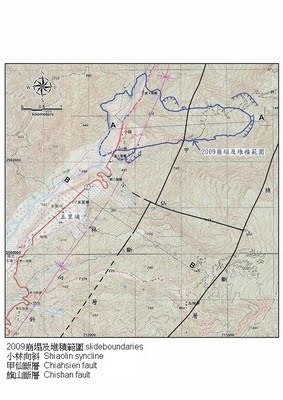
You will note two cross-section lines on the map, one of which (A-A’) runs down the axis of the landslide. This cross-section is reproduced below:
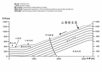
It is clear from this that the landslide is a dipslope failure – i.e. the slide has occurred on beds that are orientated parallel to the slope, and thus facilitate failure. The cross-section indicates that the rocks are a mixture of sandstone and shale. This can often cause problems as the shale is weak, impermeable and prone to weathering, whereas the sandstone is often stronger but allows the accumulation of water (i.e. pore pressure generation). The presence of the fault is an additional factor – it may well be that the movement on the fault has caused the beds to be disrupted and thus weakened. It should also be noted that this cross-section is probably only indicative. It would not surprise me to find that the river has actually eroded out the lower portions of these beds, then filled in the spaces with the terrace deposits upon which the village was built, further weakening the slope.
 Dave Petley is the Vice-Chancellor of the University of Hull in the United Kingdom. His blog provides commentary and analysis of landslide events occurring worldwide, including the landslides themselves, latest research, and conferences and meetings.
Dear Sir,Landslide near Mumbai. 10 people died. Location Saki-Naka, Lal Bahadur Sashtri Nagar Slum. 4 years back another slide occured at the same place killing 78 people.with regardsSekhar