4 September 2009
The Cikangkareng village landslide, Indonesia
Posted by Dave Petley
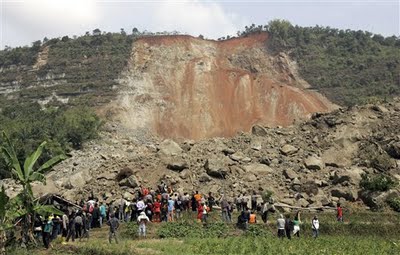
As I reported a couple of days ago, the Mw=7.0 earthquake in Indonesia on Wednesday triggered a substantive landslide in the village of Cikangkareng in West Java. This landslide buried ten houses, a mosque and an amusement (video game) arcade with the loss of about 57 lives. AP have today released images of the landslide that are quite interesting. In particular this one:
 Why is this interesting? Well, first lets note that we should ignore the red colour on the face of the scarp – this is a mantle of tropical soil that have come down from the crown of the slide (you can see the red soil at the very top of the landslide – this is of course typical of a tropical area). More important is the structure behind the mantle of soil debris. Here it is clear that the rocks are horizontally-bedded (or at least nearly so). Such a large failure in horizontally-bedded rocks is certainly not unprecedented, but is slightly surprising. The debris is very coarse-grained and has travelled quite a long way, which is also interesting.
Often, failures like this are associated with some process that has caused undercutting of the toe – for example wave erosion. Clearly there are no waves here – I wonder if there had been any activity to quarry stone from the slope, perhaps as a building material?
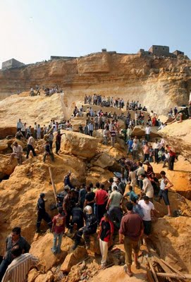
I am reminded of the Manshiet Nasser landslide in Cairo a year ago:
 In that case the key cause was probably quarrying at the foot of the slope.


 Dave Petley is the Vice-Chancellor of the University of Hull in the United Kingdom. His blog provides commentary and analysis of landslide events occurring worldwide, including the landslides themselves, latest research, and conferences and meetings.
I am so sad for the loss of lives here in
Indonesia