12 August 2008
July 2008 fatal landslide map
Posted by Dave Petley
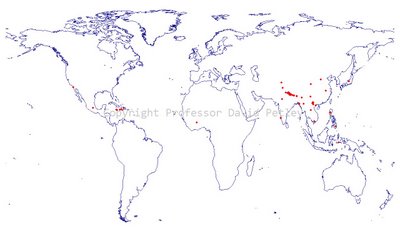
The map below shows the provisional distribution of fatal landslides for June 2008. The (again provisional) statistics are:
Number of fatal landslides: 55
Number of fatalities: 2127
Once again, the number of recorded fatalities this month has been substantially below the average for 2002-2007, which is 504 deaths. This is consistent with the monthly totals for the whole of the year – indeed at the moment 2008 has the lowest number of fatalities that I have recorded for any year, excluding the Wenchuan (Sichuan) earthquake of course. I will in due course write a post about the likely causes of this very interesting pattern.
Figure 1 shows the distribution map for July. As ever, click on the map for a bigger version. Please acknowledge any use of it or Fig. 2.
The effect of the monsoon in South Asia is now being clearly felt, with a very marked line of landslides along the southern edge of the Himalayas. The usual cluster of landslides in Central China is also clear. Once again there is a higher incidence of landslides in Central and S. America than is normal.
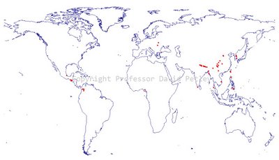
Fig. 2 shows all of the recorded fatal landslides in 2008 to the end of July, excluding those associated with the Wenchuan (Sichuan) earthquake. The typical annual patterns are now becoming clear, with clusters in Central China, S. Asia along the southern edge of the Himalayas, the Philippines and Central / S. America. There are certainly more recorded fatal landslides in the latter area so far this year than has been the pattern over the last few years, but there are also rather fewer in the Himalayas. The western part of the Himalayan chain (e.g. Kashmir) in particular seems to have far fewer fatalities than has been the case for the last few years.
 Fig. 2: Recorded fatal landslides in 2008 up to the end of July. Each dot represents a single landslide. Click on the map for a larger version in a new window.
Please leave a comment about this map and dataset! I would really like to know what you think about the data, the maps and the general approach.
Of course, if you know of an event that I might have missed I would like to hear from you...


 Dave Petley is the Vice-Chancellor of the University of Hull in the United Kingdom. His blog provides commentary and analysis of landslide events occurring worldwide, including the landslides themselves, latest research, and conferences and meetings.