
18 May 2008
Landslides after the Sichuan Earthquake – the major threats
Posted by Dave Petley
I thought it would be useful to summarise the key issues / threats associated with landslides in the aftermath of the Sichuan earthquake that I can see at the moment:
- Delayed landslides from the main earthquake: there is some evidence that there can be a substantial delay between the earthquake and occurrence of large-scale landslides. This is because: i) in some cases pore pressures in slopes take some days to respond to the earthquake shaking; and ii) there is a mechanism of landsliding called progressive failure, which means that the landslide evolves over time. There remains a serious risk of large-scale slope failures in the earthquake zone, notwithstanding other triggers (see below);
- Landslides triggered by aftershocks: there is also a great deal of evidence that landslides are being triggered by aftershock events, some of which are substantial earthquakes in their own right (i.e. magnitude M>6). These landslides will continue to pose a real threat in the earthquake affected areas, although this will diminish with time;
- Landslides triggered by rainfall. Unfortunately, rains are expected to return to this region on 20th May. If this rainfall is heavy then we are likely to see very substantial amounts of landslide activity. This situation will become increasingly critical as the monsoon develops. The threats posed by this must not be under-estimated. In the worst affected areas in the 1999 Chi-Chi earthquake in Taiwan, the area of landsliding increased three-fold in the next rainy season!
- Failure of landslide dams: this threat is well-reported. For example, Xinhua reports that “Massive landslides following Monday’s 7.8-magnitude earthquake have dammed rivers and lakes in several counties of southwest China’s Sichuan Province, posing threats to downstream areas, the water conservancy authority said on Sunday. Twenty-one landslide blockages had been reported in the counties of Beichuan and Anxian counties in the city of Mianyang, Qingchuan county of Guangyuan, Mianzhu and Shifang cities of Deyang, and Pengzhou city near the provincial capital Chengdu.” Fortunately, so far this appears to have been well-handled by the Chinese authorities, for which they deserve great credit. However, the ones that have failed to date will be the smaller blockages. It is the large ones that pose the real threat. I have included a little more detail on this below. However, there is also a substantial threat from very large landslide dams that might have formed in the high mountain areas, which are uninhabited. These can be absolutely catastrophic – for example, Dai et al. 2005 report a landslide dam in Sichuan that formed during the 1786 M=7.75 earthquake . This collapsed ten days later, killing over 100,000 people. There is an urgent need to survey the high mountains to find any similar landslide dams.
- Sediment production: One of the lessons of the 1999 Chi-Chi earthquake in Taiwan was that the sediment released by the landslides represents an appalling threat in its own right. This sediment is mobilised by the rains, causing massively damaging debris flows. This affects infrastructure downstream. For example, in the aftermath of the Taiwan earthquake six hydroelectric stations in the Tachia River Valley were put of commission long term by this problem. In places the sediment choked the river system, causing the river bed to rise by as much as 30 metres. The impact on communities and roads close to the river was terrible – last December I calculated a post-earthquake cost in this area alone of £384 million ($770 million).
All of these issues need energency attention. Hopefully the authoroties, with help from the international community, are being able to act appropriately.
Dam break landslides
Thanks to my friends Lynn Highland and Edwin Harp at the USGS for comments on this point. Lynn in particular has provided some very useful translations of Chinese articles. Two of the smaller blockages are at Beichuan. These blockages, which are considered to be very dangerous, are shown very well in this image:
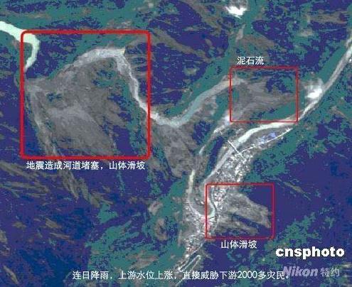 This image and associated article is from here. The translation states that:
After the Wenchuan earthquake [Note: aka East Sichuan Earthquake] the Ministry of Land and Natural Resources immediately send remote sensing aircraft to carryout out remote sensing and photography in the disaster zone to study the disaster and geological disasters caused by the earthquake. The Ministry of Land and Natural Resources provided the information to the expert group on May 15 for their interpretation. They interpreted 69 images covering between 500 square meters and 10,000 square meters. In those images they found that in 19 places rockslides from the mountains with a total volume of 100,000 cubic meters had collapsed or slid off the mountainsides. Roads or bridges were damaged in 38 places, for a total stretch of road damaged of 5.39 kilometers. The debris slide blocked the Jianjiang River in Beichuan County. If the there is a heavy rainfall soon, this could result in the break of this natural dams. Moreover there are also six places where d
ebris slides of 500,000 to 1,000,000 cubic meters could create a new disaster if there were to be an aftershock or heavy rains. The Ministry of Land and Natural Resources has asked that the Land and Natural Resources bureaus of disaster-affected provinces such as Sichuan, Gansu, and Shaanxi take full advantage of technologies to save lives and so organize work on preventing geological disasters. With respect to areas where serious geological disasters may occur, suggest to the local government a plan for evacuating the local population in order to avoid deaths from secondary disasters caused by debris slides. Moreover, it is important to strengthen work on the analysis of damage to the transportation network, determine their causes and to send technical personnel to the scene to assist in and provide guidance in repairing the transportation network. (article from the China News Network by Ruan Yulin)
These images clearly cover only a small part of the affected area. There is a great deal of work to do.
Reference
Dai, F.C., Lee, C.F., Deng, J.H. and Tham, L.G. 2005. The 1786 earthquake-triggered landslide dam and subsequent dam-break flood on the Dadu River, southwestern China. Geomorphology, 65 (3-4), 205-221.
 Dave Petley is the Vice-Chancellor of the University of Hull in the United Kingdom. His blog provides commentary and analysis of landslide events occurring worldwide, including the landslides themselves, latest research, and conferences and meetings.
Thank you for this blog. I have family in Mianyang and this helps me get perspective. Keep up the good work!!