
21 March 2017
Longdendale: dam building in an area of ancient landslides
Posted by Dave Petley
Longdendale: dam building in an area of ancient landslides
Last week I was in a taxi being driven from Manchester airport back to Sheffield along the A628 road across the Pennine hills in northern England. As we were passing through the hills I was admiring the impressive landslides on the hillside above the Longdendale dams. These landslides can be seen on the southern (right) side of the valley in the Google Earth image below:
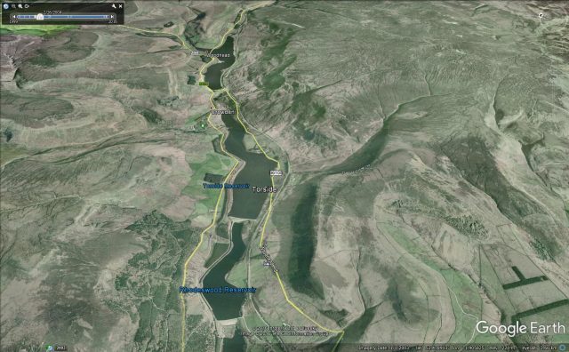
Google Earth image of the Longdendale dams and the landslides on the southern slope
.
These dams were constructed between 1848 and 1877 to provide water to the city of Manchester to the the west. These are early Victorian puddle core dams. With hindsight building such structures in an area of such obvious landsliding was courageous (though of course that was not known at the time); unsurprisingly the project hit major problems (which explains the very long construction time). To provide an illustration of the scale of the landslides, this is a Google Earth image of the Woodhead dam and reservoir, which is the highest of the sequence, with the spectacular ancient Lawrence Edge landslide on the slope above:
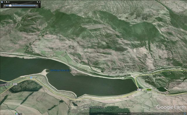
Google Earth image of the spectacular ancient landslide above the Woodhead dam in the Pennines of northern England
.
A book published by E.A. Labrum entitled “Civil Engineering Heritage: Eastern and Central England” provides a lovely description of the problems encountered with these dams. This book is available online. The first of the Longdendale dams to be constructed was Woodhead, shown above, which in the words of E.A. Labrun:
“…had geological problems in the form of the Lawrence Edge landslide on the south slope of the valley and faulted rock, heavily fissured, on the north side”
Whilst the dam was completed in 1851, it suffered severe leakage problems, requiring a new dam to be constructed. Downstream further problems with landslides were encountered during the construction of the Rhodeswood dam (this can be seen on the first Google Earth image above, but in this case I suspect the landslide is on the north side of the valley). The landslide was ultimately stabilised with drainage adits.
These dams and slopes are of course actively monitored now, and show no sign of instability. Further up the valley, the Millstone Rocks landslide is considered to be active but not dangerous.
 Dave Petley is the Vice-Chancellor of the University of Hull in the United Kingdom. His blog provides commentary and analysis of landslide events occurring worldwide, including the landslides themselves, latest research, and conferences and meetings.