
17 December 2014
Landslides from the 2010 Mw=7.2 earthquake in the Sierra Cucapah, Mexico
Posted by Dave Petley
Sierra Cucapah earthquake
On 4th April 2010 a Mw=7.1 earthquake struck the Sierra Cucapah range of northern Mexico. I blogged about that earthquake at the time (though the blog post didn’t survive the migration to the AGU website so well – it works a bit better on my original blog site) because the amazing dust clouds generated by the landslides triggered by the earthquake were captured on a mobile phone camera, and were subsequently uploaded to youtube:
At the time I had a post-doctoral researcher, Dr John Barlow, working with me at Durham. He and I, together with other colleagues, became intrigued by the landslides triggered by this earthquake for a number of reasons. First, we wanted to know just how many slides would generate this sort of effect. Second, there is very little data on landslide triggering in an earthquake in an arid regime. And third, it has been hypothsised that in an arid, seismically-active area most of the erosion might be generated by earthquake-induced landslides. So we applied to the Natural Environment Research Council (NERC) in the UK, and obtained a grant to study these landslides.
This is a hazardous area, and we were strongly advised that it would be risky to spend much time in the mountains (these are human rather than natural hazards of course), so we undertook the research using remote sensing. The results (Barlow et al. 2014) have just been published in a paper in the journal Geomorphology. In the paper we calculated the volume of material that was moved into the mountain chain by the earthquake. For a thrust-type of event, this can be substantial as the mountains can be uplifted by the movement of the fault. However, in the case of the Mexico earthquake this volume would be expected to be quite small because most of the predominantly strike-slip movement of the fault. In fact, in this case we found that there was more subsidence than uplift – i.e. the net effect of the earthquake was to reduce the mountain volume.
We also mapped the landslides triggered by the earthquake. Despite the appearance from the video, there was not very widespread landsliding in the mountains – we only identified 452 landslides in total. However, we can use this to estimate the total volume of soil and rock released by landslides, which comes out at about 2.6 million cubic metres, again not a big total.
We also looked at the controls on the landslides triggered in the earthquake. We found a very strong control from slope gradient – i.e. steep slopes were much more likely to fail – and from peak ground acceleration (i.e. those slopes that had been shaken most intensely were most likely to collapse). So, if you were living on a steep slope close to the fault (where the shaking is most intense) you were at a high level of risk. But interestingly, we also found that there was a strong influence exerted by slope orientation. In particular, those slopes orientated perpendicular to the fault were four times more likely to fail than those orientated parallel to the fault. The reasons for this are not clear at present.
From the work that we’ve undertaken we have been able to generate graph of the occurrence of landslides in relation to distance from the fault in the mountains:
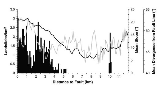
The relationship between landslide occurrence and distance from the fault, from Barlow et al. (2014)
.
The bars show the number of landslides per square kilometre, which is at a peak alongside the fault and then declines with distance. The black line shows average slope angle, which also declines away from the fault. The relationship between the landslides and the distance from the fault is generally quite simple, but at about 1.5 km from the fault the occurrence of landslides notably declines. The cause is valley orientation – this is a section of the mountains in which the valleys are orientated perpendicular to the fault, such that the slopes are parallel, as shown by the grey line on the graph. Thus landslide occurrence was much lower in this zone.
So, in conclusion, the youtube video was the inspiration to undertake a really interesting study of the landslides triggered by this significant earthquake in Mexico. As a result we now understand landslides triggered by earthquakes a little bit better.
Reference
Barlow, J., Barisin, I., Rosser, N., Petley, D., Densmore, A. and Wright, T. 2014. Seismically-induced mass movements and volumetric fluxes resulting from the 2010 Mw = 7.2 earthquake in the Sierra Cucapah, Mexico, Geomorphology, Available online 24 November 2014, http://dx.doi.org/10.1016/j.geomorph.2014.11.012.
 Dave Petley is the Vice-Chancellor of the University of Hull in the United Kingdom. His blog provides commentary and analysis of landslide events occurring worldwide, including the landslides themselves, latest research, and conferences and meetings.