
16 December 2014
Oso: The SR 530 Landslide Commission report
Posted by Dave Petley
Oso: The SR 530 Landslide Commission report
Yesterday, the Oso / SR 530 Landslide Commission released its final report – it is available online as a PDF. It its a very interesting document, carefully crafted and sensible in its recommendations. I would recommend that anyone interested in landslide, or indeed other geophysical, disasters reads the report as its findings are almost universally applicable. It is notable that the commission notes that there were many successes in the response, but that inevitably not everything went as smoothly as it could have done. Some aspects are almost bizarre – for example, the commission notes that:
On March 23, 2014, the second day following the landslide, Chief Willy Harper, District 25 (Oso), made a request to Chief Eric Andrews, Northwest Regional Coordinator for the Washington State Fire Defense Board, for a mobilization of state resources. Chief Andrews assessed the situation per state mobilization guidelines and made a formal request to the Washington State Patrol (WSP) for state fire service mobilization (all-hazards or state mobilization) under RCW 43.43.960 – -.964. This request was denied by WSP due to their legal counsel’s interpretation that state fire service mobilization resources and funding is available only for fire disasters.
Not surprisingly the commission recommends that this strange anomaly is put right.
However, in the context of this blog the most interesting aspects pertain to the landslide hazard and risk elements. Here the Commission makes a three key recommendations (amongst many others):
1. Support a Statewide Landslide Hazard and Risk Mapping Program
The Commission recommends the Legislature significantly expand data collection and landslide mapping efforts, which will provide the foundation for sound public and private land-use planning and decision-making.
The report provides more detail about how this should be undertaken, in particular with the use of lidar data. It is also suggests prioritization of transportation corridors, residential areas, urban growth areas, emergency evacuation routes and some forest lands. The work should be undertaken by the State Geological Survey, be subject to peer review and be overseen by a technical advisory group. The Commission illustrates the structure of this programme with the following diagram:

SR 530 Landslide Commission vision for landslide hazard management
.
It is hard to disagree with this recommendation, and indeed it is reported that the Governor has requested a budget of $36 million for “improved mapping and other landslide mitigation measures”. Whether this budget is granted is a different matter of course. My only criticism of this recommendation is in terms of the use of the information. Hazard maps are only useful if there is clarity in how and when they are to be used, and by whom. In particular it is perhaps slightly surprising that there is no mention of risk assessment or mapping, but perhaps this is considered to be a step too far at this point.
.
2. Establish a Geologic Hazards Resilience Institute
The Commission recommends the Governor explore the creation of a geologic hazards resilience institute to address education, outreach, and research needs, professional practice guidelines, and other geologic issues impacting Washington communities.
In my view this is the most interesting recommendation, and the one that could have the greatest long term impact. The vision is for an institute that provides support by:
-
Assisting tribal, state, and local governments to establish programs and staffing to address local geologic hazards.
-
Providing accurate information on geologic hazards and risks relevant to land use planners as well as to the general public.
-
Identifying needs and providing training for geohazard specialists; for example, ICS training, and other training that assures successful emergency response.
-
Establishing public information response protocol for emergencies.Enhancing public education and awareness programs and partners.
-
Identifying long-term research and education/outreach funding partners.Conducting educational, outreach, and research activities.
If such an institute were to be established then Washington State could become a world leader in hazard management, a very exciting prospect.
.
3. Conduct Landslide Investigations
The Commission recommends the Department of Natural Resources (DNR) Division of Geology and Earth Sciences, Washington State Department of Transportation (WSDOT), Snohomish County, and the US Geological Survey (USGS) conduct landslide investigations to characterize the mechanisms that activated the landslide and to understand the stability of the landslide mass.
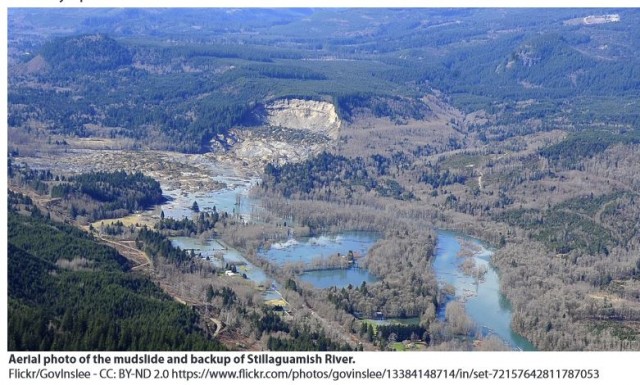
Oso landslide overview, from the SR 530 Landslide Commission Report
.
I cannot over-emphasize just how important this is. Undertaking a proper, detailed assessment of this landslide, and others as they occur, using a combination of detailed mapping, drilling, monitoring, lab testing and modelling is vital if we are to understand where such hazards will occur in the future. Opinion remains divided as to whether the incredibly destructive, fast and long runout of the landslide could have been foreseen (I remain convinced that it could have been), but we still need to understand properly the mechanisms that allowed this behaviour to occur. Proper forensic investigations are the key. Interestingly, this will be discussed in detail at the AGU Fall Meeting on Friday – I wish I could be there for both the poster session and presentations).
So overall, I think that this is an excellent report that deserves to be both read widely and to be implemented properly. It will be interesting to see what happens to the budget requests over the next few months.
 Dave Petley is the Vice-Chancellor of the University of Hull in the United Kingdom. His blog provides commentary and analysis of landslide events occurring worldwide, including the landslides themselves, latest research, and conferences and meetings.