
27 September 2009
Photos and text from a visit to the Shiaolin landslide in Taiwan
Posted by Dave Petley
The aim of this post is to present an initial interpretation of the Shiaolin landslide, based upon a couple of days of fieldwork by Chris Massey and myself over the past two days. The interpretation here, which I have written (so don’t blame Chris!) should be considered to be provisional at best. At the end of the post there are some thoughts about future work. We have no intention at this stage of publishing our analysis – that is for others to do – and so are happy for others to develop the ideas presented here. If so, we would just ask for acknowledgement in any resulting publications and that you let us know what you have found.
Disclaimer – please note that this is a personal assessment based on a very provisional walk over survey. Far more work is needed to produce a definitive evaluation – this is not that! Please do not use this in any formal sense – that is not its purpose.
Geological setting
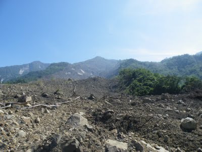
The basic geology of the landslide is an interbedded sandstone and mudstone sequence. The structure is quite complex – on the west side of the river the beds are steeply dipping, as the image below shows. The steeply dipping bedding is clearly evident on the left (west) side of the image:

Steep dips are also seen at the toe of the slope on the east side of the river near to the location of the old bridge. Further up the slope the bedding is difficult to discern, and we did not have time to get that far. There are clear planar surface visible – we interpreted these as being bedding, perhaps dipping approximately parallel to the slope, although these could have been joints. On the south edge of the landslide bedding is visible, but as the slope is steep we could not get a proper idea of the dip and dip direction. The upshot of this is that it is clear that the simple geological sections that appear to indicate a simple syncline and with failure occurring as a dipslope may not be supported by field evidence. An initial interpretation would be that there is a fault running through the valley close to the toe of the slope (probably on the right side of the image above), but this needs a great deal more detailed work.
Landslide morphology
This is an attempt to calculate some crude initial details and statistics of the landslide:
Landslide type: Rock-slide/debris-flow
Volume: 30 to 45 million cubic metres
Source area: 1.4 square kilometres
Depth (average): 20 to 30 m
Distance from crown to assumed toe (western side of river): 3,400 m
Vertical fall: 1,000 m
Angle of reach: 16°
The morphology of the slide is indicated below. To the left is the original image, to the right is the same image with annotation. The labels are meant to be indicative only – a much more robust mapping exercise would be needed to do this properly.
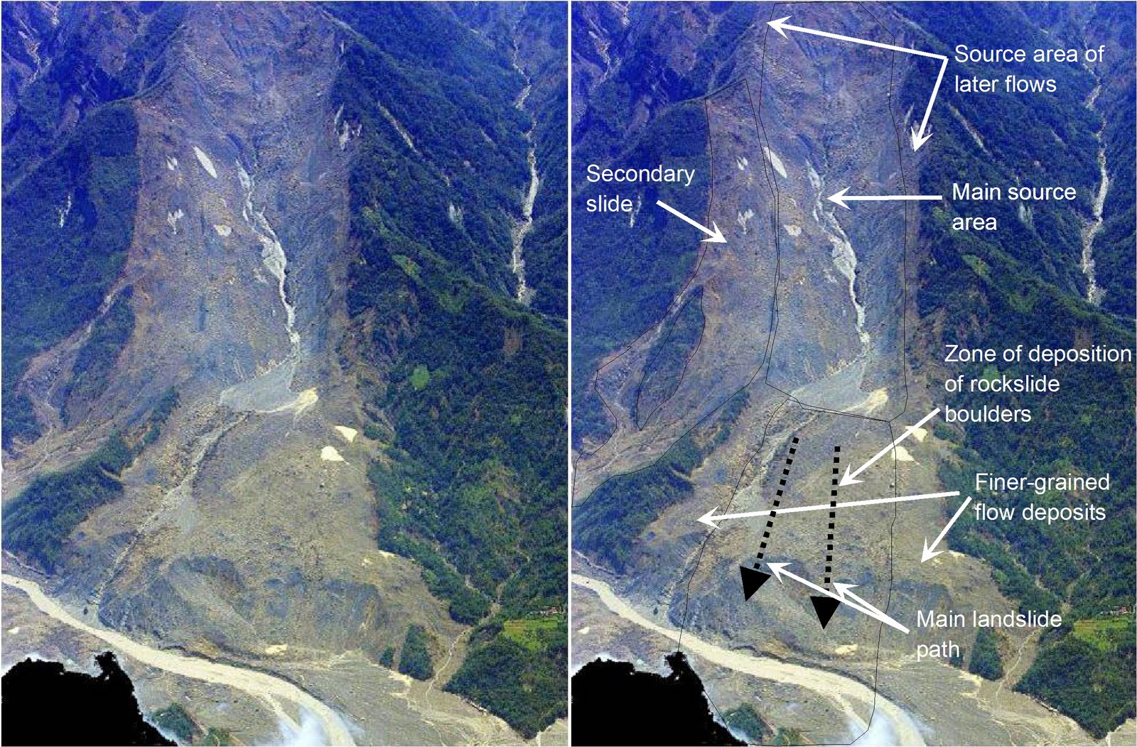 (Base image taken from a helicopter by Mr Chi)
The key points are as follows:
- There are effectively two slides at this site – the main one to the south (in the centre of the image above), and the other to the north, which is a much smaller (though still very substantial) slide. The slides are divided by a bedrock ridge for essentially their entire length;
- The main slide is a structurally controlled failure in bedrock. A large promontary high on the slope has failed and collapsed. At this point the failure is quite deep. The detachment surfaces are likely to be joints and/or bedding.
- The debris from the main failure has travelled directly downslope, unfortunately through the location of the village. In this central part the landslide appears to have been highly disrupted and to have bulldozed everything in its path;
- Most of the debris was deposited in the river channel. The river was blocked near to the old bridge, but there would also have been substantial amounts downstream. Much of this debris has been removed in the subsequent flood. It is likely that this is also the case for the remains of the village;
- The main rockslope failure was followed by a complex series of debris flows that have deposited finer grained, matrix supported materials on top of, and on the flanks of, the main slide deposit. The flows form distinct lobes that could be mapped. In some cases there is intact vegetation associated with them;
- The final phase of deposition was of fluvially reworked sediments.
The main rockslide
The main event appears to have been a catastrophic failure of a large area of the upper part of the landslide. Failure was without doubt structurally controlled, as evidenced by the surfaces visible in the scar:

This failure transitioned into a high speed failure that ran straight down the hill, across the first terrace and into the river, taking the lower terrace with it. The remains of this deposit are clear, including large boulders This one is on the river bed, hence the fine sediment and the rounding):
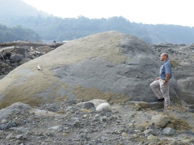
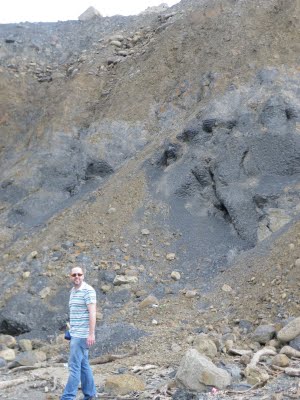
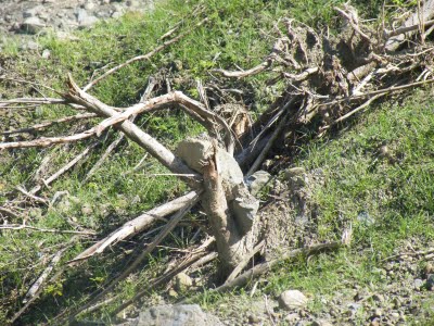
The deposit is clast (i.e. rock) supported, implying a rockslide mechanism, although there is some finer material, primarily derived from crushing and fragmentation. There are some highly shattered tree remains visible as well:

This part of the landslide appears to have run across the upper terrace, leaving some rockslide material behind, without eroding the terrace substantially. In places terraces gravels are still visible, overlain with rockslide material and underlain by bedrock:
 The lower terrace has been mostly removed, and there is little evidence of debris from the village.This might indicate that it was incorporated into the landslide mass that was deposited in the river channel. Most of this debris has been removed by the dam break flood.
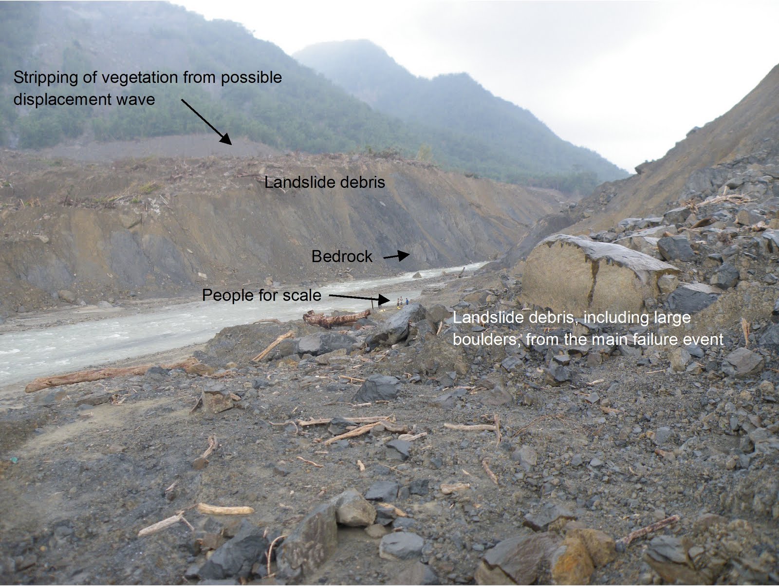
Just upstream from the old bridge (and from the village) the river channel is quite narrow. Landslide debris is found on top of the terrace on the far side of the river. Above this debris the slope has been stripped of trees and vegetation. This could be the outcome of a possible displacement wave. It appears that the main channel was blocked at this location by the landslide debris:
 Subsequent debris flows
There is lots of evidence of subsequent debris flows overlying the main rockslide debris. These vary in character but all have a fine matrix with clasts. Some of these debris flows appear to contain little vegetation other than very splintered wood:
 However, in other locations large amounts of vegetation are present, some of it still quite green with foliage:

On the margins of the slide these flows have bifurcated, leaving areas with in situ vegetation in place. In some cases there is evidence that rocks have travelled over these vegetated surfaces, leaving blocks caught in tree remains:
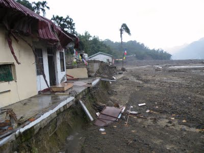
The dam break and flood
We did not really spend much time examining the remains of the subsequent flood. However, there are two houses left standing from the southern edge of the village. These show the after effects of the flood very clearly, even though the river was very wide at this point:
 Downstream the effects are severe, with damage to bridges, embankments and even the river bed. For example, the central spans of this bridge have been washed away:
 Future studies
The text here is no substitute for a detailed examination of this site. We are sure that this is being undertaken by our colleagues in Taiwan. For example, to understand this landslide properly there is a need for a full geological and geomorphological mapping exercise, including a structural geology assessment. It would be great to see an attempt to reconstruct the multiple events by mapping out the different lobes. The landslide should also have been recorded on the seismometer network, so an analysis of this might help to constrain what happened, and indeed to allow the event to be tied to the rainfall events that have been recorded from this storm. An interpretation of stallite and aerial imagery from before the slide would also be good. There is a need to reconstruct the terrain before and after the slide – using aerial images from before and ideally LIDAR data from the present. This would allow a calculation of the mass balances of the slide and of the geometry. Later on stability assessment based upon geotechnical testing could be undertaken, and ultimately even full modelling (although it is not clear what purpose this would serve). We are sure that all of the above is planned or under way (and a lot more as well) – the results will be very interesting.
A final disclaimer
All of the above is based on no more that a brief walk over survey. None of what is written here should be considered to be authorative or a substitute for a detailed survey. What is written here is the personal opinion of the author only and should not be used formally in any way.
Comments and thoughts welcome of course!
 Dave Petley is the Vice-Chancellor of the University of Hull in the United Kingdom. His blog provides commentary and analysis of landslide events occurring worldwide, including the landslides themselves, latest research, and conferences and meetings.
[…] After the storm hit Taiwan, Ekström noticedsomething strange on global seismic charts—their wiggles indicated that a cluster of events, each with shaking exceeding a magnitude 5 earthquake, had occurred somewhere on the island. “Initially, no other agency had detected or located the four events that we had found, so it seemed very likely that we had detected something special,” Ekström explained. A few days later, news reports of landslides—including the monster that swept through Xiaolin—began to pour in, confirming what the scientists hypothesized about the events’ source. A view within the debris of Taiwan’s Xiaolin landslide. Photo by David Petley […]