
4 February 2019
The speed of the Brumadinho tailings dam landslide
The speed of the Brumadinho tailings dam landslide
The two important videos showing the Brumadinho tailings dam landslide allow some estimates to be made of the speed of the movement. Both videos are time-stamped, allowing some parameters to be deduced.
The video showing the collapse itself is available here:-
.
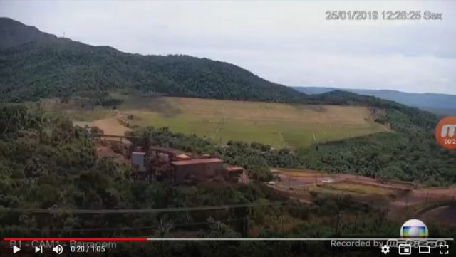
The failure process is first visible at 12:28:25:-
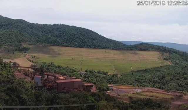
The initiation of the failure that generated the Brumadinho tailings dam landslide. Still from a Youtube video.
.
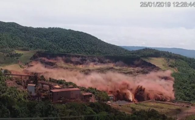
Incidentally, I have seen some suggestion that the failure initiated at the toe. I see no evidence for this in the video, as the image above shows. The dark line at the crest of the dam is the first sign of the rear scarp opening as the main portion of the dam subsides. There is no obvious failure event in the toe at this point (though it was undoubtedly moving):-
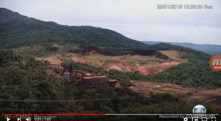
The still below shows the front of the Brumadinho tailings dam landslide / debris avalanche reaching a fairly distinctive structure below the dam:-
The passage of the Brumadinho tailings dam landslide. Still from a Youtube video.
.
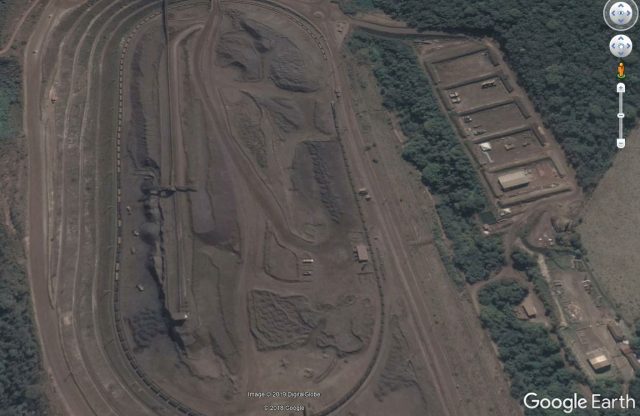
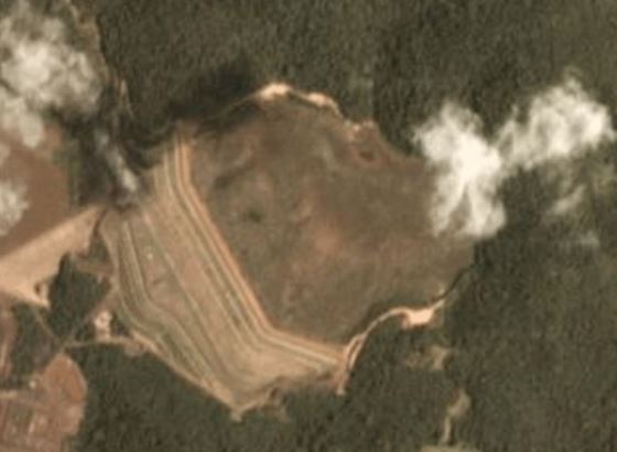
This structure can be clearly seen in the Google Earth image below:-
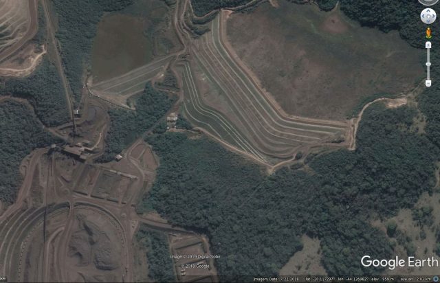
Google Earth image of the location of the Brumadinho tailings dam landslide
.
The distance from the toe of the dam to this point is about 300 metres, the imagery suggests that the landslide covered this distance in about 9 seconds, giving a velocity at this point of about 33 m/sec, or about 120 km/h. This is a very rapid acceleration, suggesting extremely rapid weakening of the debris mass. This seems to point to a liquefaction mechanism.
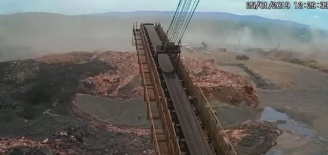
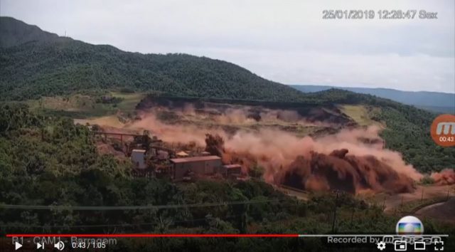
The next video shows the front of the flow arriving in the processing area below the dam. This is the video:-
.
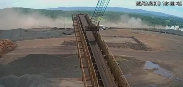
The arrival of the Brumadinho tailings dam landslide at the processing plant. Still from a Youtube video.
.
This site can also be clearly seen in the Google Earth imagery:-
Google Earth image of the location of the processing plant shown in the Brumadinho tailings dam landslide video.
.
The direct line distance from the structure below the dam considered above is about 460 m (total distance from the dam toe is about 760 m), and the time stamp is 12:29:09. Thus, in this second phase the landslide traveled 460 m in the time between 12:28:44 and 12:29:09, i.e. 25 seconds. This indicates an average velocity of about 18.4 m/sec, or 66 km/h. Thus, this was still a very rapid landslide, although as the video shows it had slowed appreciably by this point. The structure of the landslide mass at this point is quite interesting, as the still below shows:-
The structure of the Brumadinho tailings dam landslide at the processing plant. Still from a Youtube video.
.
The red mass is undoubtedly the tailings, whilst the grey is probably the remains of the starter embankment (and perhaps other embankments) at the toe. If so the deposit has remained well segregated, which may tell us something about the failure process.
There has been a lot of speculation in the media about the activities of the people who were on the dam at the time of the failure. Vale has released a statement saying that they were undertaking routine work:
“In the specific case of the footage broadcast by the media on Friday (01/02), which showed the exact moment when the Dam I breached at the Córrego do Feijão mine in Brumadinho, the professionals who appear in the footage in the dam area were performing routine tasks. One of the activities performed included the collection of data for compliance with legal requirements, as determined by the Brazilian Mining Agency. It is important to highlight that no construction works were being carried out at Dam I.”
The footage suggests that this is true. There does appear to be some coring activity though, with the rig being visible on the footage:-
Possible coring activity prior to the initiation of the Brumadinho tailings dam landslide. Still from a Youtube video.
.
And there is an article online that describes the experiences of the operator of this rig (who, amazingly, survived the landslide, though his colleagues did not). This includes this image of the equipment on the dam:
A coring rig on the tailings dam at Brumadinho. Photo: Arquivo personal / Lieuzo Luiz dos Santos, via Globo.
.
Apparently, this was being used as follows:-
“The drilling is responsible for drilling and monitoring the movement of dams. On the day of the tragedy, Lieuzo had just drilled to install a gauge that would gauge the pressure of the dam.”
I am reminded of the Rissa quick clay landslide in Norway in April 1978. Famously, this landslide of about 5 million cubic metres was triggered by a farmer undertaking a small excavation of a pit as part of the construction of a new barn. Is it possible that this landslide was so close to failure that minor disturbance from the drilling triggered a runaway liquefaction event, and thus the collapse? If so this of course would not the fault of the individuals operating the equipment, it would simply be the straw the broke the camel’s back.
1 February 2019
First thoughts on the Brumadinho dam collapse video
First thoughts on the Brumadinho tailings dam collapse video
The video that has emerged today in Brazil showing in high resolution the collapse the Brumadinho tailings dam is apparently genuine, no matter how sensational this might seem. The video is on Youtube, and is absolutely amazing:-
.
Let me include three stills from this video that illustrate what appears to have happened. The first shows the very start of the failure process At the crest of the dam active deformation can be seen – the dark line is a scarp forming as the mass moves downwards. The toe is probably bulging, but this is not really clear:-
The inititiation of failure at the Brumadinho tailings dam. Still from a Youtube video.
.
The second shows the failure fully developed. The slope is going through a massive rotational failure that extends across the full width and involves the full height of the dam:-
The front of the mass is starting to break up. The third shows the transition to a high velocity flow:-
The development of failure and transition to a flow at the Brumadinho tailings dam. Still from a Youtube video.
.
Further rotational slips are occurring on the back scarp, but the front of the flow is travelling very rapidly. To me this look to have the characteristics of a debris avalanche rather than a debris flow – the presence of so much dust suggests that this frontal portion might not be saturated. But I would be interested in other views.
The remarkable thing here is that the mass failed as a single landslide involving the full width and full height. There is now sense of a small slip destabilising the mass, or of a series of events, or of retrogression. I find this surprising.
There is also footage now of the flow downstream. That is also deeply alarming:-
.
I really hope that this video will bring home the need for proper tailings management, and thus worldwide change. There can be no better illustration of just how terrifying and deadly these failures can be.
Brumadinho disaster: the extent of the environmental impact
Brumadinho disaster: the extent of the environmental impact
The human cost of the Brumadinho disaster in Brazil is becoming increasingly clear. Latest reports suggest that there are 110 known fatalities, of whom 71 have been positively identified, and a further 238 people remain missing. Six people remain in hospital. The cost of this disaster feels very real when you look at this news report, which provides details of just of few of the victims. In addition, the environmental impact of the disaster is also apparent. The image below, collected by Planet Labs, shows the area covered by the tailings:-
Planet Labs image showing the area covered by the tailings in the Brumadinho disaster. Image copyright of Planet Labs, used with permission.
.
The area affected is somewhat smaller than that of the Samarco disaster in Brazil. The total ecological destruction in the river is clear. There is now an urgent need to retain the remaining tailings left in the storage area and to contain the waste, and any toxins draining from it, in the river channel.
Meanwhile, there remains considerable speculation as to the causes of the disaster. The image below is a Planet Labs image collected on 25th January 2019, showing the dam that collapsed to generate the Brumadinho disaster:-
Planet Labs image of the site of the Brumadinho disaster, collected on 25th January 2019, two days before the collapse. Image copyright of Planet Labs, used with permission.
.
This image shows no obvious indications of ongoing work on the tailings dam itself, and there are no signs of work on the tailings stored in the pond. Indeed. there is also no obvious indication of the incipient failure developing. Thus, the events that led to the collapse remain intriguing, and it is going to be important to ascertain the causes if similar accidents are to be avoided.
The paper on the dam that I highlighted earlier this week (Pirete and Gomes 2013) shows that the dam was built using the upstream method. This is a cross-section of the structure:-
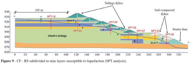
Indicative cross section of the tailings dam that collapsed to generate the Brumadinho disaster. Diagram from Pirete and Gomes (2013).
.
In this case most of the retaining structure is built upon the tailings themselves. This is not unusual, and it is not necessarily unsafe, but it does assume that the properties of the tailings are well-understood. Note in particular that the tailings are described as being dilative – there is a nice primer on the mechanical behavior of tailings here, but in essence dilative tailings are assumed to show strain hardening, i.e. they will become stronger as they deform. This may be a key assumption on the context of this failure. It is perhaps worth looking at the report of the Samarco tailings dam accident, which attributed the collapse to an extrusion process. In this case, failure also developed in a dam built using the upsteam method. The original design assumed that a layer of sand sitting over the tailings would be kept in an unsaturated state, but this was changed during construction, and the sands were allowed to become saturated. Ultimately, this allowed a so-called lateral extrusion event to develop, precipitating the collapse of the dam.
The operator of the site, Vale, are reported to have decided to remove all tailings dams of this type. It will be interesting to see the timescale for these plans, and how they will monitor the stability of these structures in the interim so as to ensure no repeat of the Brumadinho disaster.
References
Pirete, W. and Gomes, R.C. 2013. Tailings liquefaction analysis using strength ratios and SPT/CPT results. Soils and Rocks, 36 (1), 37-54.
Planet Team (2019). Planet Application Program Interface: In Space for Life on Earth. San Francisco, CA. https://www.planet.com/.
Acknowledgement
Thanks to Robert Simmon of Planet Labs for his help in acquiring and processing the imagery.
30 January 2019
Planet Labs image of the Brumadinho tailings dam failure
Planet Labs image of the Brumadinho tailings dam failure
Planet Labs have captured a high resolution image of the aftermath of the Brumadinho tailings dam failure at the Córrego do Feijão Mine in Brazil. This image, which is copyright Planet Labs and used with permission, shows the tailings pond and failed dam:-
Planet Labs high resolution image of the aftermath of the Brumadinho tailings dam failure in Brazil, captured 28 January 2019. Copyright Planet Labs, used with permission. Please note that the label has now been corrected.
.
It is worth comparing that image with the Google Earth image of the same site:-
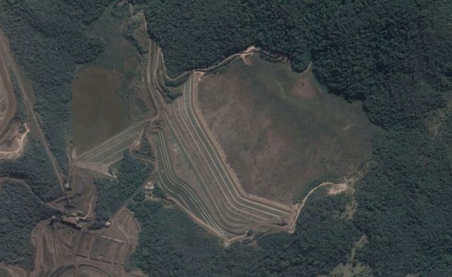
Google Earth image of the site of the Brumadinho tailings dam failure. Image dates 22 July 2018.
.
There are a few points to note here. First, the central portion of the dam has failed catastrophically, creating a high mobility flow. In fact, very little of the dam itself is intact. Second, the compromised smaller dam to the west of the main failure can also be seen. The toe has scoured out; clearly this needs careful monitoring but the retained volume is not very large. Third, there is a substantial volume of tailings left within the pond that now has not retention in place. These tailings can mobilise in heavy rainfall, so careful management is needed.
Meanwhile the number of fatalities from the Brumadinho tailings dam failure has now reached 84 confirmed losses, of whom 42 have been identified, with a further 276 people reported missing. This would mean that the minimum final total will be 318 fatalities, making this one of the worst mining landslides in recent history. No-one was rescued alive yesterday.
Five people from Vale and from a contractor, TÜV SÜD, were arrested yesterday in relation to the accident.
Finally, a comment by Caner Zanbak from my earlier post on the Brumadinho tailings dam failure noted that there is an article online about the behaviour of the tailings at Dam 1 of the Córrego do Feijão Mine. This presents a detailed analysis of the liquefaction potential of the tailings. It concludes:
“Considering a rapid rise of the phreatic line through the tailings deposit reaching the toes of the intermediate rising dykes, with complete saturation of tailings layers susceptible to liquefied, a post-triggering analysis indicated that the flow failure susceptibility of the Dam I is low even under a such critical loading event”
and
“The conclusions of these analyses, in addition to laboratory testing program results and based on rigid management procedures adopted in field, demonstrate that Dam I constitutes a safety structure against mechanisms from liquefaction-induced failures”.
Clearly these analyses did not properly characterise the behaviour of the tailings (which is not necessarily a criticism of the authors). I wonder if we know why?
Reference
Planet Team (2018). Planet Application Program Interface: In Space for Life on Earth. San Francisco, CA. https://www.planet.com/.
27 January 2019
The scale of the tailings dam collapse at Feijão mine in Brumadinho, Brazil
The scale of the tailings dam collapse at Feijão mine in Brumadinho, Brazil
The disastrous and tragic tailings dam collapse at Feijão mine in Brumadinho, Brazil is already fading from the attention of the international media, despite about 300 fatalities and a global-scale scandal. I will come back to the latter point below, but it is worth first examining the scale of the collapse at Feijão mine. The tailings dam that collapsed so dramatically is the one shown below, from Google Earth:-
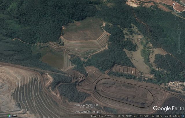
Google Earth image of the tailings dam that collapsed at Brumadinho in Brazil on 25t January 2019.
.
This view appears to support the reports that the tailings pond was not in use at the time of the collapse – the vegetated pond shown above would seem to imply that tipping had ceased. As an aside, the second structure that is now considered to be at risk is shown in the centre left of the image.
The scale of the collapse is breathtaking. The image below was tweeted by John O’Leary:-
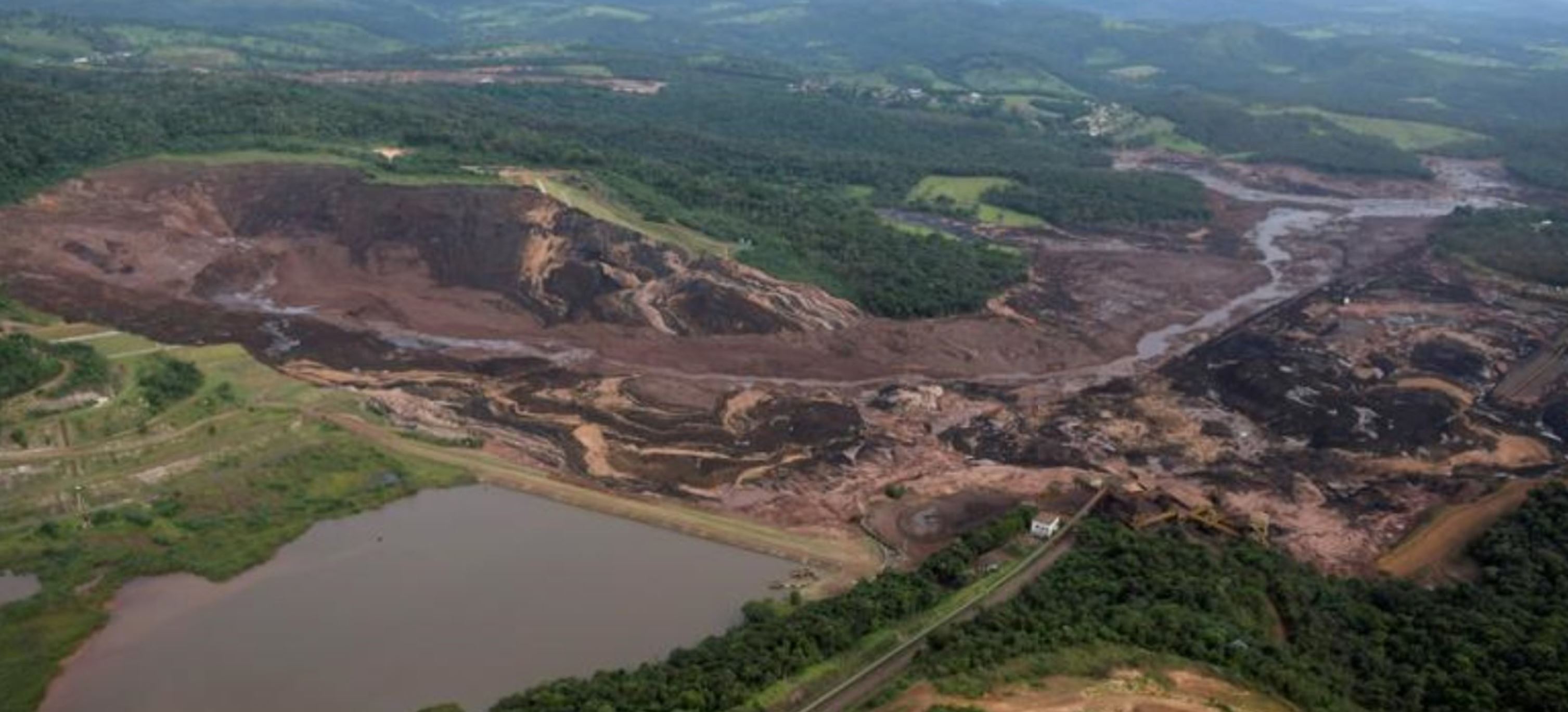
Image tweeted by John O’Leary showing the collapsed tailings pond at Brumadinho in Brazil.
.
This is clearly a complete collapse of the retaining structure, which was tall and steep, with most of the tailings having been mobilised into a high velocity flow. Note the complete destruction of the various buildings in the Google Earth image above, presumably accounting for the large numbers of fatalities.
The tweet by John O’Leary also shows the second dam that is considered to have a high potential for failure. This dam has been badly damaged, and the risk appears to be high:-
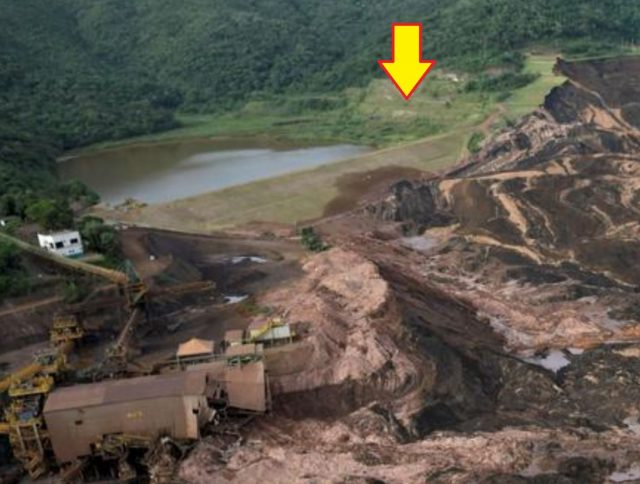
Image tweeted by John O’Leary showing the compromised tailings dam at Brumadinho in Brazil.
.
There is a presentation online showing the various tailings structures owned by Vale in this area, published in 2016. The tailings dam at Feijão mine in Brumadinho that collapsed is Slide 44 in the presentation:-
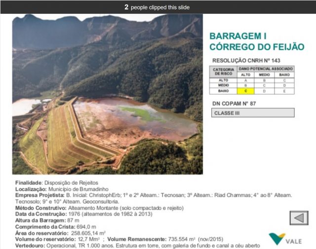
Vale assessment of the risk of the tailings dam that collapsed at Brumadinho in Brazil.
.
This assessment appears to indicate that the potential losses were assessed as being high should the dam collapse, but that the potential for this to occur was considered to be low. Clearly that was not correct, even though the assessment appears to post-date Samarco.
The presentation indicates that the dam was 87 m high, impounding almost 13 million cubic metres of waste.
But this event is indicative of a much larger global issue. The impacts of tailings dam collapses on people and the environment can be catastrophic, as this event illustrates. As such it must be incumbent upon operators to ensure that collapses cannot and do not occur under any foreseeable circumstances. But we repeatedly experience tailings dam failures – recent examples include Cadia in Australia (2018), Mishor Rotem in Israel (2017), Henan Xiangjiang Wanji in China (2016), Samarco in Brazil (2015), Mount Polley in Canada (2014), Xichuan Minjiang in China (2011) and Kolontor in Hungary (2010), amongst many, many others. No other area of geotechnical engineering would tolerate a failure rate like this, and no other area of geotechnical area would be allowed to operate in the area of the risk / consequence matrix occupied by tailings dams. That this situation is allowed to continue is an absolute disgrace.
And Vale themselves have had two major tailings dam failures in Brazil in four years. I do not need to comment further.
Acknowledgement
Thanks to reader Raphael, who found the Vale presentation on the risk associated with their tailings dams.
23 January 2019
Bureya Reservoir: blasting has started to clear the landslide dam
Bureya Reservoir: blasting has started to clear the landslide dam
The website Rivers Without Boundaries is reporting that works have now started to clear the landslide dam at Bureya Reservoir in Russia. You will remember that this is a large, valley blocking landslide that occurred on 11th December 2018. This generated a bit of a flurry of interest because some parties ascribed this event to a meteorite impact event, which is highly unlikely to be the case. However, the landslide dam is significant and, of course, potentially dangerous, so the authorities are rightly attempting to clear the blockage.
Rivers Without Boundaries report that in the first instance about 10 tonnes of explosives have been used in an operation that involves 400 people:-
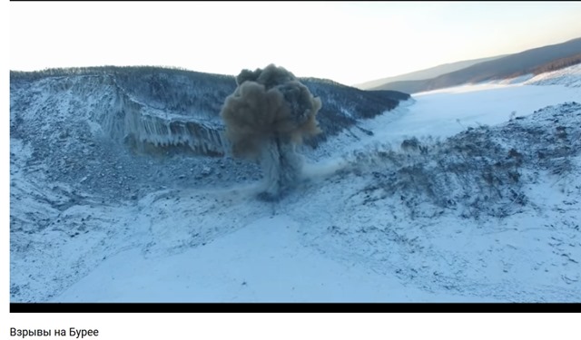
The first blast to clear the landslide blockage at the Bureya Reservoir. Image via Rivers Without Boundaries.
.
Rivers Without Boundaries point out that the effects of these operations can be seen in satellite imagery – and indeed this is the case. This is a Planet Labs image collected on 21st January. The channel being excavated using the explosives can be seen clearly:-

Planet Labs image of the Bureya Reservoir landslide site, showing the effects of the ongoing blasting work. Four band PlanetScope image collected 21st January 2018. Used with permission, copyright Planet Labs.
.
Operations are expected to take about nine days to clear the blockage.
.
Further examination of the causes of the Bureya Reservoir landslide
Interestingly, the Rivers without Boundaries has another piece that looks in more detail at the potential causes of the landslide. It rightly rejects the impact hypothesis. Most interestingly, it provides details of changes in the water level of the Bureya Reservoir in the period leading up to the collapse:-
“As we know now the site of the landslide, despite being 100 kilometers from the dam of Bureyskaya Hydro, experiences regular significant change in water level ranging from 237.6 m above sea level meters on May 25, 2018 to 253 meters ASL on December 12, 2018 (difference more than 15 meters). The landslide on Bureya occurred during the period of intensive reservoir level drawdown (5-12 centimeters a day), that is the usual phase in which other reservoirs are known to trigger landslides. So, the draw down of reservoir may well be a major factor in that case, and there is certainly a need for the owners of the dam to monitor the site carefully for other land-slide prone slopes.
“According to early reports from Dr Aleksey Makhinov, leading geomorphologist in the region, who visited the spot on December 26, the failed slope’s toes were regularly flooded in recent past. Other experts suggested it could be exacerbated by ice-cover formation on December 9-14 and by water freezing in the cracks.”
Rapid draw down is a far more likely cause than is an impact event, especially as the satellite imagery suggests that he slope had deformed prior to the collapse.
Reference
Planet Team (2018). Planet Application Program Interface: In Space for Life on Earth. San Francisco, CA.
20 January 2019
Landslides on the White Bluffs in Hanford Reach National Monument
Landslides on the White Bluffs in Hanford Reach National Monument
Geologist Bruce Bjornstad has posted a really interesting video onto Youtube showing the development of landslides on the White Bluffs in Hanford Reach National Monument in Washington State. The video, which should be visible below, combines beautifully shot drone footage with a commentary on how these landslides have developed.
.
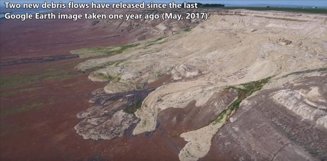
The image below provides a still from the video – these are very spectacular features:-
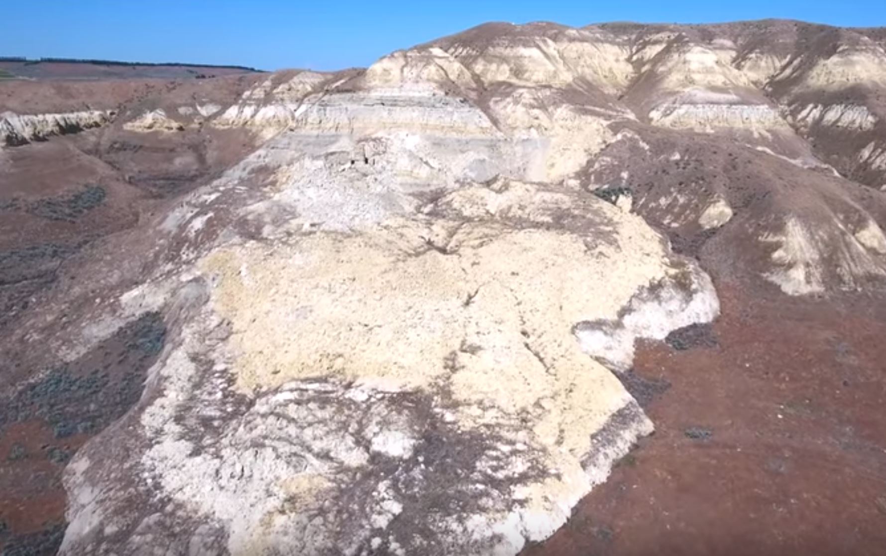
Landslides on the White Bluffs River in Hanford Reach National Monument in Washington State. Still from a Youtube video by Bruce Bjornstad.
.
In the video Bruce explains the landslide mechanism, in which irrigation water moves down through the soil before hitting an impermeable layer and spreading laterally. This moves to the bluffs on the edge of the river, driving up pore water pressure and thus triggering failure. The resultant landslides have been developing with time. The locations in which water is exiting the slope can be seen in the Google Earth imagery in the video as vegetation growth has been enabled.
The resulting landslides are causing a serious change in the morphology of the bluffs in this protected area, as the still below shows:-
Landslide on the White Bluffs River in Hanford Reach National Monument in Washington State. Still from a Youtube video by Bruce Bjornstad.
.
This is a beautiful example of the ways in which poor water management can inadvertently trigger slope problems away from the location in which the irrigation is being applied. Of course the long-term implications are damage to the bluffs (which may well have implications for the ecosystem in this location), increased sediment supply to the river (which may have downstream implications) and of course loss of land at the top of the slope. Providing excess irrigation is presumably inefficient as well, so this is an unfortunate situation.
Acknowlegement
Thanks to Bruce Bjornstad for putting together the video and for highlighting it to me.
18 January 2019
Hidroituango: the complex geology behind the major problems in the mountain
Hidroituango: the complex geology behind the major problems in the mountain
The successful closure of one of the inlet tunnels at the Hidroituango hydroelectric power scheme in Colombia has allowed a better understanding of the situation in the mountain. Noticias Caracol has a good article replaying the news from the operators, EPM, after the closure of the gate of tunnel number 2. The verdict is that the void in the mountain, which had already been identified, is providing a direct link between the two tunnels. I guess the good news that no further damage has been found. The bad news is that this is going to be complex, expensive and time consuming to resolve.
The underlying question, for which there will need to be a solution before any resolution is possible, is the geological situation that is causing these problems. This rock mass has suffered collapse events, the opening of underground cavities and, of course, major slope failures. The implication is that there is something going on with the geology in this area.
Back in July, Humberto Ortiz tweeted a video apparently showing a presentation by Carlos Albertro Solano, Vice-President of Energy Generation at EPM, in which he described the presence of two major faults running through the mountain in the area of the powerhouse cavern. The screenshot from the video below is not great, but you can see the two faults in question highlighted in red:-
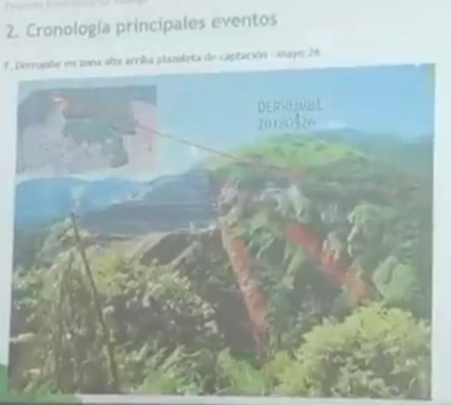
The faults at the Hidroituango site. Screenshot from a video tweeted by Humberto Ortiz in July 2018.
.
On Twitter, Zarafa has uploaded a conceptual representation of these faults in terms of the works:-
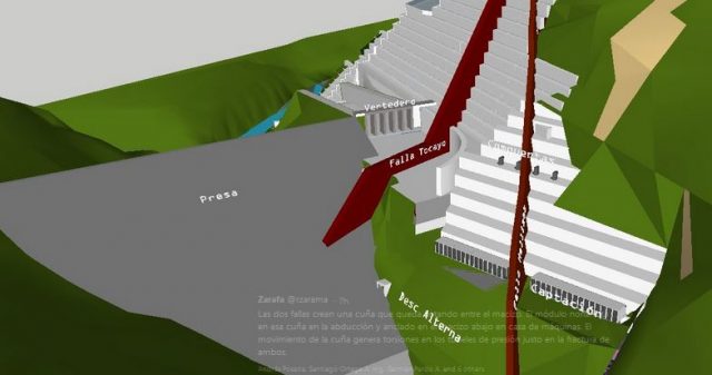
The possible fault geometry at Hidrotuango. Tweet uploaded by Zarafa
.
It is hard to know the degree to which this interpretation is grounded in fact, rather than conjecture. If this representation is correct then there is a possible explanation for the multiple problems. Close to both faults we might expect to see a highly disrupted rock mass, with shearing and greatly weakened material. Thus, the integrity of the rock in which the excavations have been undertaken might be somewhat weaker than might have been anticipated. In both representations the two faults appear to define a wedge. I suspect that it is difficult to anticipate the behaviour of this wedge in the aftermath of excavation. Is it a zone of massively weakened rock? Could it behave as a single mass and thus allow a large volume displacement? Or some sort of combination of the two? It seems quite logical to me that many of the problems that are being experienced are the consequences of such a structure.
Of course it is impossible to know the degree to which this is understood at present. I also wonder the degree to which this complex geology was identified and understood during the ground investigation. Whatever lies behind the current difficulties I think it is hard not to conclude that something has gone wrong in terms of the engineering geology of this site. If so, how did that happen in a $5 billion project?
16 January 2019
New problems at Hidroituango
New problems at Hidroituango
Last year I wrote on a number of occasions about the major problems at the Hidroituango hydro-electric project in Colombia. In the last few days new problems have emerged, although there has been very little international coverage. Last Thursday, EPM (the dam operator) announced in a press conference that a significant void had been discovered in the rock mass close to the dam. The only reports that I can find are in Spanish; Noticias Caricol has a good report that Google Translate seems to be able to interpret:-
This Thursday at a press conference EPM gave details of an unexpected discovery that is the subject of research in the project.
The manager in charge of EPM, Jhon Maya Salazar, in the company of the mayor of Medellín, Federico Gutiérrez, the governor of Antioquia, Luis Pérez and the mayors of Ituango and Valdivia, explained that a scour was found.
This finding according to Maya Salazar occurred during the drilling work that was being done to close the gates of the powerhouse.
The manager indicated that two holes were made between the unloading tunnels 1 and 2 that connect to the machine house, “the first excavation was through rock and perfect, nothing was found. Then in the second perforation, not vertically but diagonally, at 30 or 40 meters there is a vacuum, which tells us that there is a scour”
My interpretation is that these are the tunnels that represent the water inlets to the turbines, which are located in a huge cavern, shown below:-
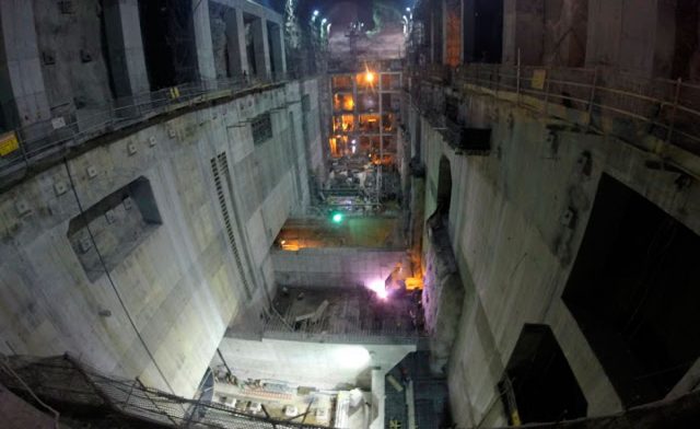
The machine house at the the Hidroituango dam prior to the flood. Works are now under way to ascertain the level of damage. Image via: https://www.ituangoenergiadecolombia.com/
.
Two of these tunnels are currently allowing water to flow uncontrolled through the machine house (the others are intentionally blocked). To ascertain the damage there is a need to close these two open tunnels. Unfortunately, the exploratory drilling has found this large void between them. At the time of writing it was not clear to me as to whether this is a void made by the flow of water since the problems started, or it had been present from the start. Either way, this appears to be deeply problematic for the project.
Meanwhile, works are underway now to start to ascertain the level of damage to the powerhouse, induced when water flooded the tunnels in an uncontrolled manner last year. To this end, one of the two open gates (Gate 2) to the machine house will be closed today, with the second being closed in a few weeks time. It will be interesting to see what they find. Most of the dam has been evacuated, and warnings remain in place downstream. However, the operation is not considered by the authorities to be high risk.
15 January 2019
Two new landslide videos: Lebanon and Russia
Two new landslide videos: Lebanon and Russia
Two new (to me at least) landslide videos have been posted onto Youtube:-
A landslide in Lebanon
There have been a number of reports of landslides in the Lebanon since the start of the year. Reports on 9th January described a landslide on the Tyre – Sidon highway, injuring one person. Then on 14th January a landslide injured three people on the Chekka – Batroun highway, injuring three people. There are warnings of more landslides to come.
On 7th January, the following video was captured in Lebanon. It is not clear as to where this landslide occurred:-
.
An earthflow in Russia
Meanwhile, a video has emerged, apparently captured in Russia in 2012, although there is very little information about it:-
.
This is a pretty dramatic event. Reports say that the trees are being felled by an earthflow, and there are signs of that on the road:-
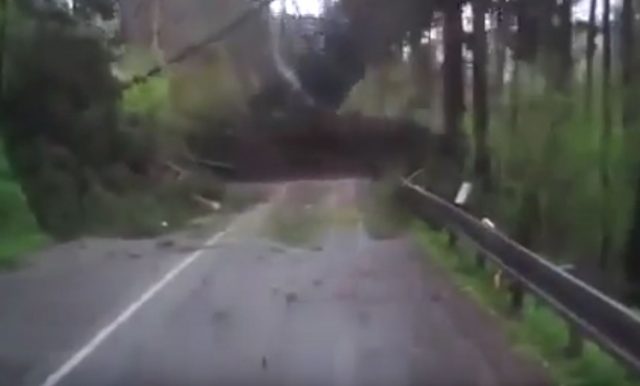
.
The number of trees being felled suggests that the landslide was occurring across a broad front. It would be interesting to know how this ended.
Thanks to Ellen Brundige for highlighting the Russian earthflow to me.
 Dave Petley is the Vice-Chancellor of the University of Hull in the United Kingdom. His blog provides commentary and analysis of landslide events occurring worldwide, including the landslides themselves, latest research, and conferences and meetings.
Recent Comments