
30 January 2019
Planet Labs image of the Brumadinho tailings dam failure
Posted by Dave Petley
Planet Labs image of the Brumadinho tailings dam failure
Planet Labs have captured a high resolution image of the aftermath of the Brumadinho tailings dam failure at the Córrego do Feijão Mine in Brazil. This image, which is copyright Planet Labs and used with permission, shows the tailings pond and failed dam:-
Planet Labs high resolution image of the aftermath of the Brumadinho tailings dam failure in Brazil, captured 28 January 2019. Copyright Planet Labs, used with permission. Please note that the label has now been corrected.
.
It is worth comparing that image with the Google Earth image of the same site:-
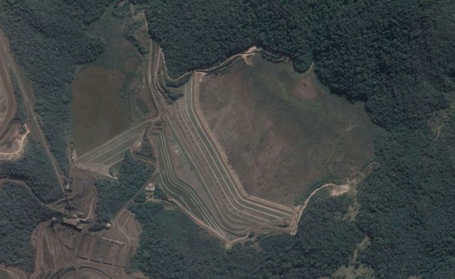
Google Earth image of the site of the Brumadinho tailings dam failure. Image dates 22 July 2018.
.
There are a few points to note here. First, the central portion of the dam has failed catastrophically, creating a high mobility flow. In fact, very little of the dam itself is intact. Second, the compromised smaller dam to the west of the main failure can also be seen. The toe has scoured out; clearly this needs careful monitoring but the retained volume is not very large. Third, there is a substantial volume of tailings left within the pond that now has not retention in place. These tailings can mobilise in heavy rainfall, so careful management is needed.
Meanwhile the number of fatalities from the Brumadinho tailings dam failure has now reached 84 confirmed losses, of whom 42 have been identified, with a further 276 people reported missing. This would mean that the minimum final total will be 318 fatalities, making this one of the worst mining landslides in recent history. No-one was rescued alive yesterday.
Five people from Vale and from a contractor, TÜV SÜD, were arrested yesterday in relation to the accident.
Finally, a comment by Caner Zanbak from my earlier post on the Brumadinho tailings dam failure noted that there is an article online about the behaviour of the tailings at Dam 1 of the Córrego do Feijão Mine. This presents a detailed analysis of the liquefaction potential of the tailings. It concludes:
“Considering a rapid rise of the phreatic line through the tailings deposit reaching the toes of the intermediate rising dykes, with complete saturation of tailings layers susceptible to liquefied, a post-triggering analysis indicated that the flow failure susceptibility of the Dam I is low even under a such critical loading event”
and
“The conclusions of these analyses, in addition to laboratory testing program results and based on rigid management procedures adopted in field, demonstrate that Dam I constitutes a safety structure against mechanisms from liquefaction-induced failures”.
Clearly these analyses did not properly characterise the behaviour of the tailings (which is not necessarily a criticism of the authors). I wonder if we know why?
Reference
Planet Team (2018). Planet Application Program Interface: In Space for Life on Earth. San Francisco, CA. https://www.planet.com/.
 Dave Petley is the Vice-Chancellor of the University of Hull in the United Kingdom. His blog provides commentary and analysis of landslide events occurring worldwide, including the landslides themselves, latest research, and conferences and meetings.
Good afternoon.
I can’t tell by the picture if it really is Brumadinho. But the name on it says Bento Rodrigues, and Bento Rodrigues is the dam failure that happened in 2015.
I was once a surveyor and engineer on a 1.5 km-long tailings dam project for a large multi-national. The dam was compacted rock fill with internal cobble drainage system. It was built by the downstream construction technique, rather than the upstream method that appears to have been used at Córrego do Feijão. (The difference between these techniques is easily searched online.) The slimes were kept well away from the dam through continuous placement of coarse sand on the upstream side, using a system of cyclones perched along the crest. It was expensive but safe. I do not know the how or why of this particular failure, but wanted to reiterate what is probably obvious, that safe tailings dam construction is both technically and economically feasible.
I’m not sure if it’s the image of Brumadinho in this picture or not, but it’s written “Bento Rodrigues” and that’s the dam failure that happened in 2015.
Professor and Colleagues:
In support of a baseline Mine Operations Tailings Structure Monitoring paradigm — as the first SatSAR data starts to come out — the displacement and velocity were moving too fast for Satellite (SAR) to capture more than potential precursors some months before –(that is called phase ambiguity –SatSAR providers sometimes toss it out — it is THE indicator that you NEED to bring in or switch to your GbSAR data that could be acquiring in the 45 seconds to <2 minute differential range.)
I am not sure why there is such a gulf between SatSAR and GbSAR providers — see this from the Mt. Polley Review Panel submissions …. where lessons for the industry were supposed to have taken root — Note Thought No 9 (joint SatSAR and GbSAR actions)
https://www.mountpolleyreviewpanel.ca/sites/default/files/SUB00008_2014-12-05_METZCOMM%20Services%2C%20LLC.pdf .
Costs mentioned here have been reduced on the rental side by 2/3 ….this implementation and joint effort is possible today anywhere on the globe.
Vale announces the decommissioning of all its upstream tailings dams
http://www.vale.com/EN/aboutvale/news/Pages/Vale-announces-the-decommissioning-of-all-its-upstream-tailings-dams.aspx
Hi Dave,
After (quickly) reading the Soil and Rock article, like youy I was a little bit doubtful on the analysis… the flow failure potential safety factor found is between 1.14 and 1.36, so this means “moderate” to “low” (not only “low” as written) using the proposed range. As a geotech, I use a SF of 1.5, expecting an “unlike” potential failure, even for common slope safety management… For such a dam, a SF of 1.5 or more would be the least to have…
Here is a good description of raised embankment designs. There are three main types, downstream, upstream and centreline structures.
http://www.tailings.info/disposal/conventional.htm
Re the upstream type, … The construction of an upstream designed embankment starts with a pervious (free draining) starter dyke foundation. The tailings are usually discharged from the top of the dam crest creating a beach that becomes the foundation for future embankment raises (Vick 1990). … Where the tailings properties are suitable, natural segregation of coarse material settles closest to the spigot and the fines furthest away (not always the case with thickened tailings discharge). …
Some speculation. Perhaps partial sealing of the starter dyke foundation could cause the phreatic surface (water table) behind the wall to rise increasing the load on the wall leading to failure. It could be that reduced flow from the dyke base was misinterpreted as being due to the dam’s decommissioned status when maybe some of the reduced flow was due to decreased permeability of the starter dyke structure, in my opinion of course.
I read somewhere that the starter dyke for this dam was constructed mainly from ore fines.
Here is a video with the exact moment of the dam collapse.
https://www.youtube.com/watch?v=XRc6pikwKZo
New and verified footage:
https://youtu.be/l5zjjUicHGE
https://youtu.be/dJCvqb5Mxq4