
18 January 2019
Hidroituango: the complex geology behind the major problems in the mountain
Posted by Dave Petley
Hidroituango: the complex geology behind the major problems in the mountain
The successful closure of one of the inlet tunnels at the Hidroituango hydroelectric power scheme in Colombia has allowed a better understanding of the situation in the mountain. Noticias Caracol has a good article replaying the news from the operators, EPM, after the closure of the gate of tunnel number 2. The verdict is that the void in the mountain, which had already been identified, is providing a direct link between the two tunnels. I guess the good news that no further damage has been found. The bad news is that this is going to be complex, expensive and time consuming to resolve.
The underlying question, for which there will need to be a solution before any resolution is possible, is the geological situation that is causing these problems. This rock mass has suffered collapse events, the opening of underground cavities and, of course, major slope failures. The implication is that there is something going on with the geology in this area.
Back in July, Humberto Ortiz tweeted a video apparently showing a presentation by Carlos Albertro Solano, Vice-President of Energy Generation at EPM, in which he described the presence of two major faults running through the mountain in the area of the powerhouse cavern. The screenshot from the video below is not great, but you can see the two faults in question highlighted in red:-
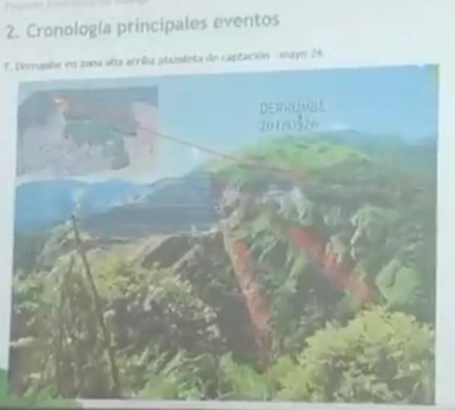
The faults at the Hidroituango site. Screenshot from a video tweeted by Humberto Ortiz in July 2018.
.
On Twitter, Zarafa has uploaded a conceptual representation of these faults in terms of the works:-
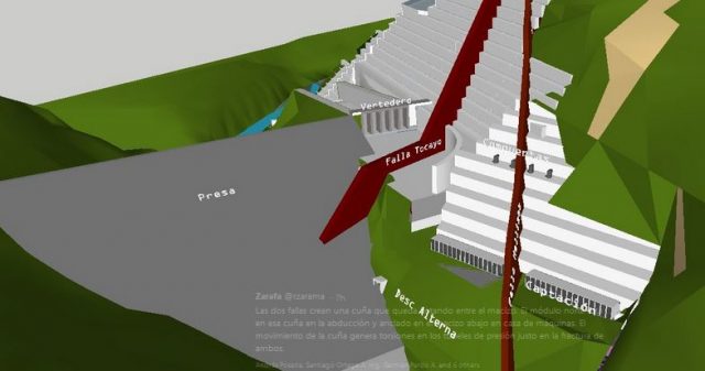
The possible fault geometry at Hidrotuango. Tweet uploaded by Zarafa
.
It is hard to know the degree to which this interpretation is grounded in fact, rather than conjecture. If this representation is correct then there is a possible explanation for the multiple problems. Close to both faults we might expect to see a highly disrupted rock mass, with shearing and greatly weakened material. Thus, the integrity of the rock in which the excavations have been undertaken might be somewhat weaker than might have been anticipated. In both representations the two faults appear to define a wedge. I suspect that it is difficult to anticipate the behaviour of this wedge in the aftermath of excavation. Is it a zone of massively weakened rock? Could it behave as a single mass and thus allow a large volume displacement? Or some sort of combination of the two? It seems quite logical to me that many of the problems that are being experienced are the consequences of such a structure.
Of course it is impossible to know the degree to which this is understood at present. I also wonder the degree to which this complex geology was identified and understood during the ground investigation. Whatever lies behind the current difficulties I think it is hard not to conclude that something has gone wrong in terms of the engineering geology of this site. If so, how did that happen in a $5 billion project?
 Dave Petley is the Vice-Chancellor of the University of Hull in the United Kingdom. His blog provides commentary and analysis of landslide events occurring worldwide, including the landslides themselves, latest research, and conferences and meetings.
Very interesting!
Thanks.
Is this the same project?
https://www.youtube.com/watch?v=pABKhTHP83M