
8 July 2014
Komansu rock avalanche: a landslide with exceptional runout
Posted by Dave Petley
Komansu rock avalanche
The Komansu rock avalanche is described in a new paper by Robinson et al. (2014), which has recently been published online by the journal Landslides. The landslide is located in the Alai Valley of Kyrgyzstan, in the Trans Altai range of the Pamir Mountains. The landslide deposit is ancient – the slide has been dated at 5,000 to 11,000 years BP, which is the period after the retreat of the glaciers in this region.
The Komansu rock avalanche is both very large and quite hard to see. This is a perspective view Google Earth image of the landslide – I’ve annotated the key parts of the slide, based on the interpretation in Robinson et al. (2014):
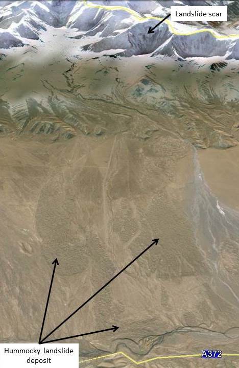
Google Earth perspective image
.
The current landslide deposit has an estimated volume of 3 – 5 cubic kilometres (although a large part of the deposit has been eroded away), and covers an area of 64 square kilometres – i.e. this is a very large landslide indeed, and we’d expect such a large landslide in very steep, high terrain to have a long run-out. Empirical relationships from similar events suggest about 10 km. However, the Komansu rock avalanche has a run-out that is much longer than this – about 26 km – which asks real questions about the dynamics of the landslide. In other words, what was special about this landslide that allowed it to go so far? An obvious explanation is that the landslide volume was much larger than the modern deposit suggests, but given that the source area only has a volume of about 4 cubic kilometres, this then poses the question as to the origin of the additional material.
Robinson et al. (2014) have compared the hummocky topography of the landslide deposit with that of other large landslides from this region. This is a Google Earth perspective view of the deposit:
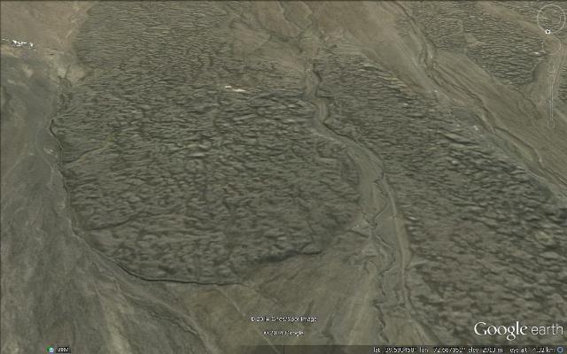
Google Earth perspective view
.
Whilst on the face of it the deposit might look a little strange, it is very similar to that found in many other large rock avalanches both in this area and more widely. From this perspective, the landslide is not unusual. The one mechanism that is known to generate usually long runouts is the presence of large amounts of snow and ice – i.e. that is a so-called rock-ice avalanche. However, such landslides tend to have a distinctive final morphology; Robinson et al. (2014) suggest that the Komansu rock avalanche deposit does not match this. An alternative, but similar possibility is that the landslide ran-out over a glacier within the valley, but again the morphology does not seem to match that observed from other known examples.
Robinson et al. (2014) suggest that the unusual mobility might be explained by the presence of a large amount of ice in the initial failure, and that the landslide then entrained a large volume of material from within the valley. So, the authors propose that the initial failure was about 4 cubic kilometres of rock together with about 500 million cubic metres of ice. This very large landslide then entrained about 4 cubic kilometres of sediment in the valley, plus additional glacial ice, to generate a flow that behaved in a manner that was similar to a volcanic debris flow, allowing the very long runout distance.
A final observation in the paper is that such landslides have substantial implications for hazard assessment in high mountain areas. These giant rock avalanches with long runout distances are clearly extremely destructive. As people increasingly populate the high mountains the likelihood of a mass fatality event, especially during a very large earthquake, increases.
Reference
Robinson, T.R., Davies, T.R.H., Reznichenko, N.V. and De Pascale, G.P. (2014). The extremely long-runout Komansu rock avalanche in the Trans Alai range, Pamir Mountains, southern Kyrgyzstan. Landslides, DOI: 10.1007/s10346-014-0492-y
 Dave Petley is the Vice-Chancellor of the University of Hull in the United Kingdom. His blog provides commentary and analysis of landslide events occurring worldwide, including the landslides themselves, latest research, and conferences and meetings.
Dave,
In Google Earth, there’s a Panoramio icon (Farm in Alay Valley) at 39° 35′ 35″ N, 72° 53′ 54″ E which shows contained (entrained?) boulders bigger than horses – if the Panoramio icon is correctly located.
Also, do you think the dark- grey deposit crossing the E-W-striking bedrock units around 39° 34′ 20″ N, 72° 19′ 16″ E is a (multiple?) mudflow or similar, about 1.5km long?
Bill
That Panoramio is correctly placed however its actually in the Ashiktash glacial moraine deposit; the Komansu deposit is the next hummocky deposit to the West. The hummocks in Ashiktash are very much larger and chaotic than in the Komansu and only reach about half way across the Alai Valley. On a brief visit to Ashiktash we think these large boulders are glacial erratics. There are far fewer boulders exposed at the surface in Komansu but clear evidence of entrained material was found at one of the only sites with a cross section visible. Unfortunately I can’t find a decent photo of it on Google Earth however.