
3 May 2019
Bajo Llojeta: a major landslide, with dramatic videos, in La Paz, Bolivia
Posted by Dave Petley
Bajo Llojeta: a major landslide, with dramatic videos, in La Paz, Bolivia
Over the last few days, but primarily on 30th April 2019, a major landslide affected the community of Bajo Llojeta in La Paz, Bolivia. There are a number of dramatic videos of this event, most of which have featured the collapse of houses as the rear scarp of the landslide has undergone retrogression. In fact the most remarkable videos capture the main body of the landslide. This is an astonishing example that captures the movement of the toe of the landslide, with some sense of the damage in the urban area:-
.
From this video it is clear that this is a very large, rapid (for this type of landslide), retrogressive earthflow. The damage to the properties involved in Bajo Llojeta is total. News reports suggest that 64 houses were destroyed, affecting 88 families. The retrogressive nature of the landslide might well mean that further properties will be at risk. The destructive nature of the landslide is well-captured in this video:-
.
Note the movement event from about 2 minutes into the film, possibly caused by a rotational failure in the back scarp that then triggered an undrained loading event in the main landslide deposit?
There is a very interesting aspect to this landslide that is well-captured in the above video, and shown in the screenshot below:-
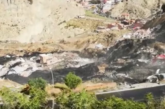
The landslide at Bajo Llojeta in La Paz, showing the remains of the landfill in the landslide debris. Still from a video posted to Youtube
.
The material involved here is very black, and is clearly different from the surrounding geology. There is an explanation for this in a news report (in Spanish – translated by Google):-
As explained by the mayor of the city, Luis Revilla, “the land was mixed with old rubbish” and there was “a strong infiltration of water in the cracks of the landslide started in San Jorge Kantutani”. No fatalities have been reported, but two have disappeared. According to preliminary data, the landslide has affected 88 families and left 64 homes damaged.
So it appears that this was an unplanned settlement built on a landfill site. The reports indicates that there were significant inadequacies in the local drainage and sewerage system. This may have had a cumulative effect – i.e. initial movement of the landslide disrupted the drainage, allowing water to enter the slope, which deformed, and so on.
The location of the landslide is -16.519, -68.121. This is a Google Earth image of the site, I believe:-
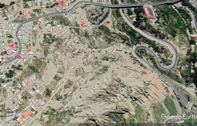
Google Earth imagery of the site of the landslide at Bajo Llojeta in La Paz, Bolivia. Image from April 2019.
.
Fortunately there are no reported fatalities from this landslide. Landslides are common in La Paz, this thesis by Nick Roberts explains the setting (this is the abstract, the full thesis can be downloaded:-
“La Paz lies in a deeply incised valley on the Bolivian Altiplano. It has experienced frequent damaging historic landslides and numerous, much larger, prehistoric landslides…The upper part of the sediment sequence beneath the Altiplano is glacial in origin and fines distally away from the Cordillera Real. It records at least 15 late Pliocene and Early Pleistocene glaciations, most of which predate the oldest known North American continental glaciation. The plateau surface formed by ca. 1.0 Ma, but most likely before ca. 1.8 Ma. After that the headwaters of the Amazon River extending westward through the Cordillera Real incised the underlying sediments. The poorly lithified fill sequence is exposed in steep slopes, promoting instability. Between 1995 and 2014, La Paz experienced 43 discrete landslides and slow ongoing landslides at 13 additional locations. Landslides were most frequent late in the rainy season and generally happened after particularly wet periods weeks in length, indicating a strong hydro-meteorological control.”
 Dave Petley is the Vice-Chancellor of the University of Hull in the United Kingdom. His blog provides commentary and analysis of landslide events occurring worldwide, including the landslides themselves, latest research, and conferences and meetings.
Big outburst of black fluid at 3:55 in the second video confirms overpressured material.
PS: someone’s cat visible at 2:55 running along the edge of the sidewalk. Hope it made it. 🙁
Looking to the upper left at the valleys in the distance, the entire area appears to be out of equilibrium. Lots of sheer walls with slides and slumps in front of them, some covering enormously large areas. Closer in, spires in unconsolidated sediments. Bad situation.
Not a lot of geotechnical and civil engineers getting hired by big engineering-construction firms to do borings, stability analysis, moisture content analysis, shear strength, etc. before anything is built there. No regional plan for drainage, or storm water management or roads or residences. None of that is happening in places like La Paz. No money for that. No social infrastructure to support that.
Instead, locals move into an undeveloped area and start building, and people move in because they can afford it and it’s somewhere to live. This is and was reality for most of humanity’s existence. It’s only very recently, in the last 100-200 years in the highly developed West, mainly, that the economy and social institutions are robust enough that sufficient resources and knowledge are available to do those things as a matter of course.