7 May 2019
Bajo Llojeta landslide: a high resolution Planet Labs SkySat image
Posted by Dave Petley
The Bajo Llojeta landslide: a high resolution Planet Labs SkySat image
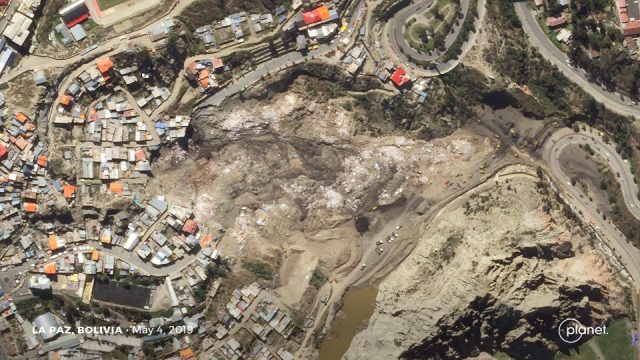
Last week I featured the remarkable and dramatic Bajo Llojeta landslide in La Paz, Bolivia, which destroyed many houses. Planet Labs have kindly tasked a SkySat satellite to collect a high resolution image. This was obtained on 4th May 2019:-

Planet Labs SkySat image of the site of the Bajo Llojeta landslide in Bolivia. Image collected by Planet Labs SkySat, used with permission. © Planet Labs 2019.
.
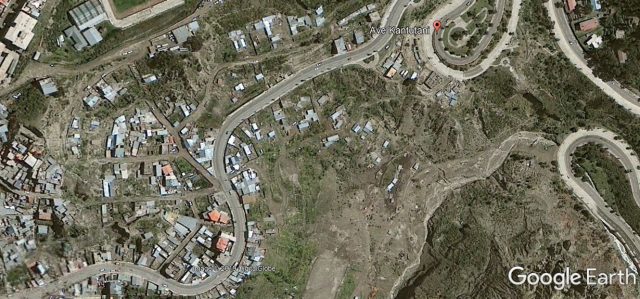
It is worth comparing this image with the Google Earth imagery of the site prior to the landslide. I have tried to capture the same area:-

Google Earth image of the site of the Bajo Llojeta landslide in Bolivia. Image collected by Digital Globe on 13th February 2013. © Google Earth / Digital Globe 2019.
.
The image captures the scale of the landslide and the level of destruction to the buildings. The landslide is clearly an earthflow type event, with a retrogressive rotational back scarp, showing multiple phases of movement. The deposit on the road at the toe has been cleared away, and earth moving equipment can be seen on the southern edge of the landslide near to the toe. A substantial number of properties are at severe risk in the vicinity of the head scarp.
An article on Los Tiempos indicates that an additional 22 houses in the headscarp area will need to be demolished, in addition to the 68 homes lost in the Bajo Llojeta landslide. In total this affects at least 180 families and 431 people. The local government has apparently promised to rehouse the affected people, and I very much hope that this will happen. In my experience such promises are often not delivered, unfortunately.
Reference and acknowledgement
Planet Team (2019). Planet Application Program Interface: In Space for Life on Earth. San Francisco, CA.
Thanks to Robert Simmon for help in acquiring the SkySat image.


 Dave Petley is the Vice-Chancellor of the University of Hull in the United Kingdom. His blog provides commentary and analysis of landslide events occurring worldwide, including the landslides themselves, latest research, and conferences and meetings.
It remembers me of Morro do Bumba landslide in Niterói, Brazil, in 2010. It was also because of irregular construction over an old landfill. But it happened quickly and during nighttime, burying entire families.
I lived in Niterói at that time. It was very disturbing to hear the helicopters at distance. And as you said, promises to properly rehouse the survivors stayed as promises.
The landslide has dammed off the stream. I wonder how they are mitigating flood risk.