15 March 2018
Llusco, Peru: a dramatic landslide has destroyed 100 houses
Posted by Dave Petley
Llusco, Peru: a dramatic landslide has destroyed 100 houses
A major landslide at Llusco in the Cusco region of Peru over the last few days has led to the destruction of over 100 houses, and the declaration of a state of emergency by the government. The local authorities have stated that the landslide was caused by high pore water pressures, rather than by seismic activity. The landslide is reported to cover an area of about 30 hectares. The best images that I have seen of the landslide reside in a Youtube video that was shot by a drone by Fameco Films and Art. This should be visible below:-
.
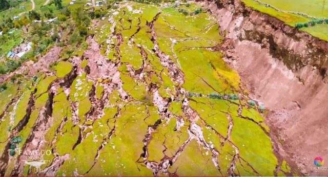
Based on this video the landslide appears to be a very large slump, with movement of a very large block. However, the shear surface is, I suspect, non-circular, which has caused the block to fracture extensively. This can be seen in the image below, taken from the video:-

Extensive fracturing in the displaced mass at Llusco in Peru. Image from a drone video posted to Youtube by Fameco Films and Art.
.
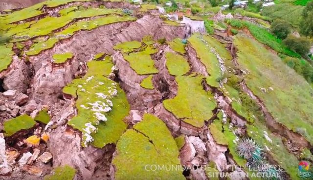
The toe portion of the landslide has suffered very extensive fracturing and deformation, with a large amount of extension of the mass:-

Deformation of the frontal portion of the displaced mass at Llusco in Peru. Image from a drone video posted to Youtube by Fameco Films and Art.
.
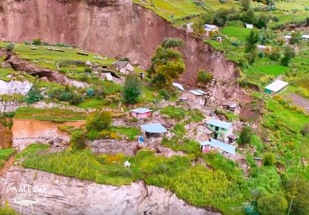
Unsurprisingly this has caused very extensive damage to the houses, which are no longer habitable. The size of the fractures between displaced blocks is quite remarkable:

Damaged houseson the landslide at Llusco in Peru. Note the size of the fractures that have opened between the displaced blocks.Image from a drone video posted to Youtube by Fameco Films and Art.
.
In many ways this landslide feels quite similar to the Seafront landslide (often known as the Cow Slide), triggered by the Kaikoura earthquake in New Zealand.


 Dave Petley is the Vice-Chancellor of the University of Hull in the United Kingdom. His blog provides commentary and analysis of landslide events occurring worldwide, including the landslides themselves, latest research, and conferences and meetings.
The scarp in the Seafront landslide, N.Z. is c. 45 degrees. The scarp in the Llusco, Peru landslide is 90 degrees. One influence is the degree of weathering of the soil mass, coupled with the underlying rock. Of course shear strength of the soil mass is a major parameter.
There is a major landslide here in Bohol Id. in which the scarp on the (c.1.8Ma age limestone) Great Maribojoc Landslide of Oct. 15 2013 is vertical, 9 mH. It was seismically induced and has remained vertical in some five years of typhoons and climate change events. In other words, it is seismically controlled.
It would be interesting to know what is the underlying rock mass and its parameters of all the landslides and how the degree of weathering couples with the landslide to trigger the event.
Habitats on potential landslides are a major problem to life.
By the way, the video of the Llusco Peru landslide is professionally well made and put together. Thank you to those who produced the video
Amazing footage. Wonder if destruction of habitat/trees contributed to this slippage?
Peruvian geological survey (INGEMET) published comprehensive report about the landslide (http://www.ingemmet.gob.pe/-/informe-del-deslizamiento-de-campanayocpata-llusto-cusco) where you can find some nice dron views. Some major conclusions are:
– the event from 23.2.2018 represents reactivation of a known active landslide
– in December 2017, INDECI (civil defence office) made a landslide risk study concluding the risk level to be so high that the community should be evacuated from the site
– the landslide occured in weathered volcanic rocks as a result of precipitations, enhanced water infiltration by human activities and stream erosion
– it formed small dam and little lake on the stream
– the landslide is being monitored with GPS
what effects do the landslide cause?