
19 September 2019
Mine waste landslides at the Kumtor Goldmine in Kyrgyzstan
Mine waste landslides at the Kumtor Goldmine in Kyrgyzstan
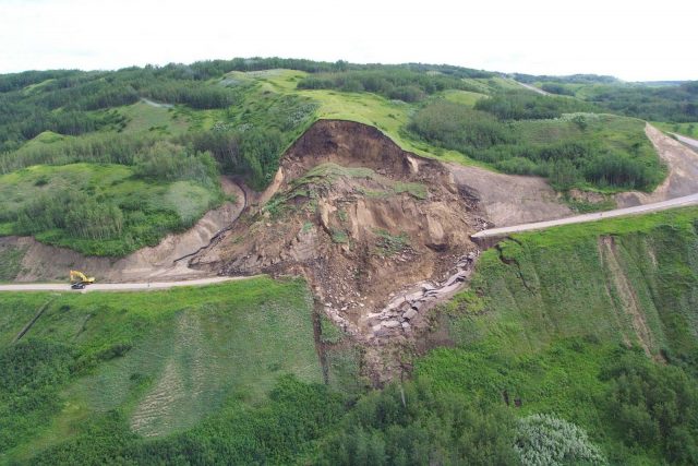
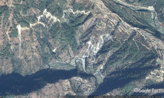
In the course of some work that I’m undertaking on human-induced landslides, I have come across an interesting article (Torgoev and Omorov 2014 – available online) about landslides at the Kumtor Goldmine in Kyrgyzstan (location = 41.868, 78.169). This site is unusual as the mining is being undertaken at an unusual elevation, 3,000 – 4,400 metres above sea level, at a site that has active glaciers. The mining waste is being dumped into a glaciated valley, allowing the development of a large landslide. Fortunately this is slow-moving compared with many other mine waste landslide events. The site can be seen in the Google Earth image below, collected in August 2016. I have marked the toe of the landslide:-
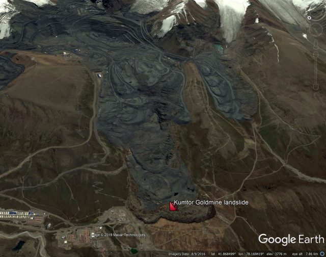
A Google Earth image of the Kumtor Goldmine landslide.
.
Torgoev and Omorov (2014) observe that by 2013 about 1 billion tonnes of mine waste and 100 million tonnes of glacial ice had been removed from the Kumtor Goldmine, and dumped in the valley. Most of the waste was dumped onto active glaciers, primarily the Davydor Glacier. This has triggered movement that is a strange hybrid of glacial flow and a landslide, although as the image above shows, the current morphology is primarily that of a mine waste landslide.
The largest landslide (but note that there are others at the site), has a volume of about 70 million m³, and a total movement distance of about 3 km based on the Google Earth image. Torgoev and Omorov (2014) report that it is about 85 metres thick, and is moving on a surface with a gradient of about 5°.
Fortunately, the rate of movement of these dumps is quite low compared with many other mine waste landslides. Geodetic data presented in the paper indicates movement rates in 2012 of about 1.5 metres per day, although a higher movement rate event was recorded in April 2013, when rates reached 5.3 metres per day. This caused the loss of some buildings:-
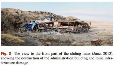
Building damage caused by the Kumtor Goldmine landslide in Kyrgyzstan. Image from Torgoev and Omorov (2014).
.
The landslide at the Kumtor Goldmine continues to move. This image is a Planet Labs PlanetScope image from 11th August 2019. I have rotated it to allow easier comparison with the Google Earth image above:-
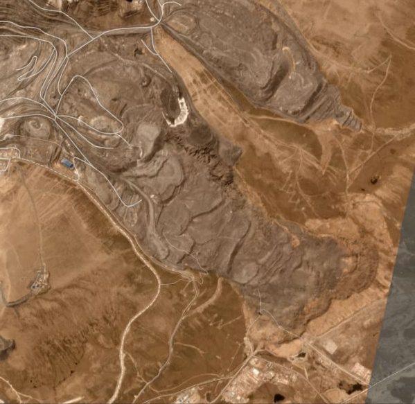
A Planet Labs PlanetScope image of the Kumtor Goldmine landslide, dated 11th August 2019. Image copyright Planet Labs, used with permission.
.
This image suggests that the landslide has continued to advance, probably more slowly than previously, whilst the toe of the landslide has started to spread laterally. The toe of the landslide appears to consist primarily of material entrained into the slide from the slopes below the dump.
This is an unusual and interesting hybrid mine waste landslide. I wonder how its dynamics might change as global heating induces temperature rises (and thus thawing of the ice) in the landslide mass.
References
Torgoev, I. and Omorov, B. 2014. Mass Movement in the Waste Dump of High-Altitude Kumtor Goldmine (Kyrgyzstan). In Sassa K., Canuti P., Yin Y. (eds) Landslide Science for a Safer Geoenvironment. Springer.
Planet Team (2019). Planet Application Program Interface: In Space for Life on Earth. San Francisco, CA. https://www.planet.com/
18 September 2019
Landslides in Art Part 30: Erica Putis
Landslides in Art Part 30: Erica Putis
This is the 30th edition of my (very occasional) series on the ways in which landslides are depicted in various forms of art. Part 29 can be found here.
This time I’m featuring a piece of work by Erica Putis, who describes herself, and her work, thus:
Erica Putis grew up in a small town in Vermont where the grass was green and the winters cold. During this time, she wandered for hours around her family’s 20 acres, continuously in awe of nature and her surroundings. Creating was always something that happened and never stopped even when she grew up…Erica’s work is inspired by her love of nature, science and beauty. She tries to find the balance between the terrifying beauty of mother nature and the fascinating anomalies of the science world. These subjects have always motivated her creativity and given her a sense of awe while living on this little place we call Earth.
This work is from a collection of work entitled Natural Destruction Series, which she describes as follows:
I grew up in Vermont and am a nature girl at heart. I am totally fascinated and terrified of natural destruction. In our current state of affairs due to climate change these beautiful but scary phenomena will continue to increase with frequency and strength. I am continuously amazed at Mother Nature and how we lack control over her. Watching the weather channel, confronting my phobia of tornadoes and studying science and geology in my spare time has inspired this series.
The works depict various geological and meteorological phenomenon, including this painting of a landslide:-
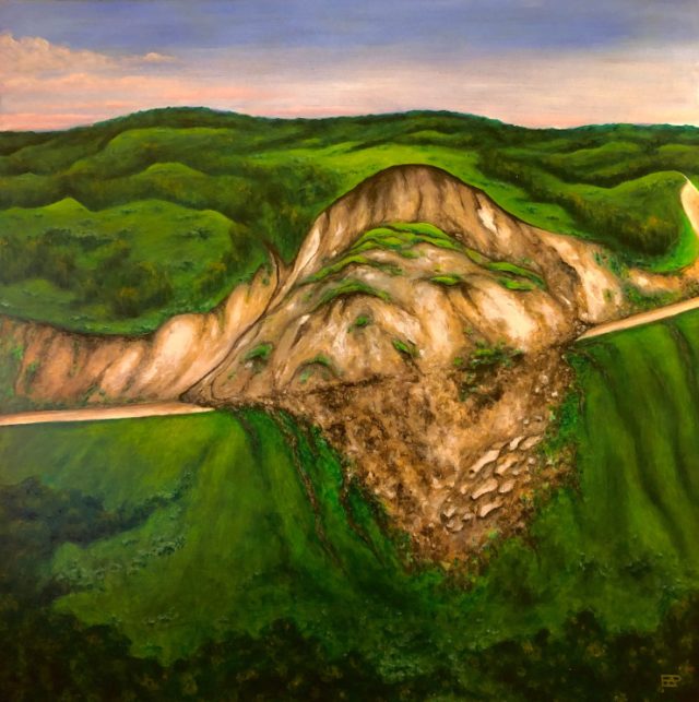
Doing the Electric Landslide by Erica Putis – Oil on Canvas.
.
This painting appears to be inspired by this photo of a landslide on Cecil Lake Road in Canada by R. Couture:-
The Cecil Lake road landslide, Peace River, photo by R. Couture (GSC), which appears to have inspired the work by Erica Putis.
.
The painting rather beautifully captures the sad destruction of the natural environment caused by the landslide. There is a sense of melancholy and loss, which cannot be captured in a photograph.
Other editions of Landslides in Art can be found here.
17 September 2019
Landslides and air blasts
Landslides and air blasts
An interesting aspect of some very large and rapid landslides is that they generate air blasts that can be highly destructive in their own right. A good example is the Langtang landslide, triggered by the 2015 Gorkha earthquake in Nepal. In that case the air blast caused huge damage even in areas not reached by the landslide debris itself. However, there has been comparatively little analysis of this phenomenon to date.
A recent paper (Zhuang et al. 2019) provides an analysis of the air blast generated by one of the large landslides triggered by the 2008 Wenchuan earthquake in China. The landslide in question, the Wenjia rock avalanche (also known as the Wenjiagou landslide), has a volume of about 50 million cubic metres and traveled about 4500 metres:-
An aerial view of the Wenjia landslide, which generated an air blast. Image from Tang et al. (2018).
.
The study by Zhuang et al. (2019) is based upon a numerical analysis of the air blast generated by the landslide. The model suggests that the rock avalanche itself lasted 210 seconds and moved with a maximum velocity of 65 metres per second (about 230 km per hour). The authors describe evidence on the ground of the resulting air blast, including mature trees snapped in half:-
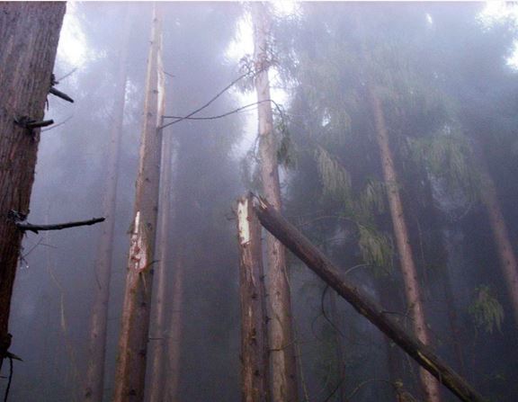
Mature trees snapped in half by the Wenjia landslide air blast. Image from Zhuang et al. (2019).
.
This type of damage was found on both sides of the landslide path and downslope from the landslide deposit. The analysis suggests that a blast wave started to form about 30 seconds after the initiation of sliding. The maximum wind speed was 35 metres per second (about 125 km per hour). This is the equivalent of a Force 12 hurricane wind, which is associated with complete devastation. The effects of the air blast extended 750 metres beyond the margins of the landslide. The model suggests that the topography had a strong control on the form of the blast that was generated.
We rarely account for the effects of landslide air blasts in hazard models. This paper is further evidence that for the very largest and most rapid landslides they can be an important mechanism for causing damage.
References
Zhuang, Y., Xu, Q. & Xing, A. 2019. Numerical investigation of the air blast generated by the Wenjia valley rock avalanche in Mianzhu, Sichuan, China. Landslides. https://doi.org/10.1007/s10346-019-01253-0.
Tang, Y., Zhang, Z., Wang, C. et al. 2018. The deformation analysis of Wenjiagou giant landslide by the distributed scatterer interferometry technique Landslides 15: 347. https://doi.org/10.1007/s10346-017-0917-5.
16 September 2019
An update on landslides from the 2019 Northern Hemisphere monsoon season
An update on landslides from the 2019 Northern Hemisphere monsoon season
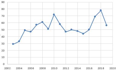
At the 2019 Northern Hemisphere summer monsoon season starts to decline, I have run a quick analysis of the landslides that I have recorded to date (following up on my post of a month or so ago looking at the number of landslides in July). Whilst the 2019 total will increase slightly as I work back through the dataset to validate it (a process that usually uncovers some unrecorded events), the graph below is the dataset up to 11th September. The plotted data shows the cumulative number of landslides and the cumulative total number of fatalities worldwide up to that date:-
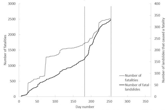
The cumulative total number of fatal landslides, and the cumlative total of the resulting fatalities, for 2019 up to 11th September 2019. Note the effects of the 2019 Northern Hemisphere summer monsoon.
.
The effects of the 2019 Northern Hemisphere summer monsoon season are clear, showing a distinctive increase in the rate of fatal landslides from about day 180 (29th June, marked with the first vertical dashed line). This dramatically increased rate persists until about day 230 (18th August), when the number of recorded events reduces back to close to the normal (background) rate. Some of these landslides after this event are of course in the monsoon affected areas – for example, although they are not in the database as yet, Nepal suffered some fatal landslides at the end of last week, with one event killing six people.
Overall, the 2019 landslide year looks to be very similar to 2018. As of the end of August I had recorded 315 fatal landslides in 2019 (this number will rise as noted above), against 319 at the same point in 2018. The average for the period 2003 to 2018 (i.e. the entire range of the dataset) is 266 landslides, so the last couple of years have been notably worse than the long term average.
I would also like to highlight an interesting aspect that I cannot really explain at the moment. This graph shows the number of fatal landslides recorded worldwide in August over the period 2003-2019:-
The total number of fatal landslides recorded in August worldwide for 2003-2019
.
It shows a generally increasing trend; August 2019 does not look exceptional (but will increase when I improve the data). By comparison, July shows quite a different pattern:-
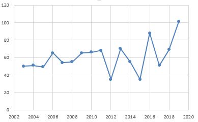
The total number of fatal landslides recorded in July worldwide for 2003-2019.
.
Again, there is a clear rising trend. But from 2011 onwards the pattern seems to have changed, with the number of recorded landslides become highly variable from year to year. 2019 is clearly the worst year on record.
This apparent change in pattern may or may not be significant, but requires further investigation.
12 September 2019
Landslides during the construction of the Morehall and Broomhead reservoirs in Sheffield
Landslides during the construction of the Morehall and Broomhead reservoirs in Sheffield
I have previously written about the problems that landslide posed to the construction of the Longendale reservoirs in the vicinity of my home town, Sheffield. My local paper, the Sheffield Star, has an interesting article this week about landslides during the construction of two other reservoirs, Morehall and Broomhead, built to supply water to the city in the early part of the 20th Century. The article, written to a highlight a guided heritage walk to the sites on Saturday 21st September, describes major landslide related construction problems, in particular at Broomhead (location is 53.46, -1.60). Part of the article describes these landslides, with the quotations being provided by Mike Atkinson, a former engineer who carried out work on Broomhead Reservoir during his career (Mike will be leading the walk on 21st September):-
In 1924, workers noticed that the hillside towards Yewtrees Lane, north of the Broomhead site, began slipping as an important overflow channel was being dug. “They realised they needed to do something,” says Mike. “They were digging the channel and the ground kept coming towards them.” A trench was dug in short lengths and a drain up to 50 feet deep was put in, filled with rubble. “That, together with removing 400,000 cubic yards of soil from the top end of the slip, seemed to stop the movement,” Mike says.
This Google Earth image shows the Broomhead reservoir. The slope that caused the problems is the forested area on the far side of the lake:-
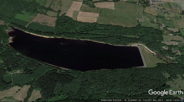
Google Earth image of the Broomhead reservoir
.
The problems at this site are documented in some detail in a paper that was published in the Journal of the Institution of Civil Engineers (Beldelow 1944). This paper names the landslide the “Waldershelf Slip”. The article documents two phases of movement, with the first starting in 1924 during the construction of the overflow works (which can be seen in the image above). Beldelow (1944) includes the following cross section through the site – the slip can be seen on the right side of the diagram, with the inferred slip plane. Note the location in relation to the level of the top of the embankment:-
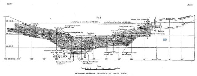
Cross section through the Broomhead Reservoir, showing the landslide on the right hand side. Diagram from Bendelow (1944).
.
To stabilise the landslide, the engineers constructed a drain to extract water from the landslide and they removed about 300,000 m³ of material from the upper part of the slope to reduce the driving load. This work was completed in 1928, and Bendelow (1944) reports that the works appeared at first to have been successful.
However, in April 1930 further movement was observed on the slope, including cracks through the overflow weir. A very detailed investigation was undertaken of the causes of the instability, including trial pits dug to a depth of up to almost 30 metres! These found evidence of slip planes through the bedrock, indicating that the slope consisted of an ancient landslide that had been reactivated by the construction of the dam and associated structures.
To stabilise the slope, the engineers removed a further 125,000 m³ of material, installed drains within the landslide mass, and constructed drains beyond the margins of the landslide to stop water from entering the unstable part of the slope.
To the huge credit of the engineers, these measures proved to be entirely successful, and 75 years after the paper was published the reservoir remains in use.
Reference
Bendelow, L. 1944. Remedial works in connexion with the Waldershelf slip – Broomhead Reservoir. Journal of the Institution of Civil Engineers 22 (6), 95-106.
11 September 2019
Xe Pian Xe Namnoy: Land stability and dam failure on the Bolaven Plateau, Laos
Xe Pian Xe Namnoy: Land stability and dam failure on the Bolaven Plateau, Laos
A guest post by Richard Meehan and Douglas Hamilton
This progress report was prepared one year after the failure of the Xe Pian Xe Namnoy dam in Southern Laos and represents ongoing research into the causes of that failure by the authors. Early post failure studies were carried out by former dam designer Richard Meehan ([email protected]) with engineering geologist Douglas Hamilton, joining more recent efforts to consider implications for the future of the Xe Pian Xe Namnoy project and of dam building generally in similar upland areas of the Mekong basin.
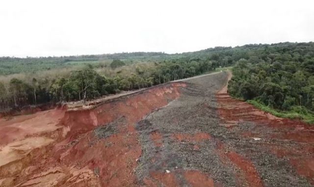
Figure 1:- The Xe Pian Xe Namnoy saddle dam failure, left abutment, from drone video. Courtesy Hankyoreh TV.
.
The mountainous terrain of landlocked Laos creates a natural buffer between its modernizing and expanding neighbors, China, Vietnam, and Thailand. In recent times Laos has been recognized as a potential hydropower asset which could modernize the country and its remote upland populations. The high topographic relief and rainfall prevailing over much of the country are attractive for the development of high-head power drops but the monsoon-driven summer timing of rain requires seasonal reservoir storage near the edges of high plateaus. The capital-short Lao government has exploited these inviting conditions by opening the country to external hydropower investment and design/construction management by its neighbors. However such ambitious plans to turn the country into a profitable “battery of southeast Asia” have stumbled on problems arising from cases of hastily built and inadequately supervised construction in remote areas on what has often proven to be unstable ground.
A notable recent example is the July 2018 failure, on first filling, of a billion cubic meter reservoir, constructed for the Xe Pian Xe Namnoy project located on the Bolaven plateau in southern Laos. An initial review of this failure by the first author were presented in late 2018, and was followed six months later by a review by an independent expert panel drawn by the Lao government from the International Committee on Large Dams (ICOLD). Both reviews concur in finding that the failure was caused by a foundation failure beneath one of the project saddle dams.
On further review by us it appeared that the geomorphologic evolution of the high-altitude terrain that provides nominally favorable dam sites also features geologic defects typical of tropical areas that tend to make the ground and supporting structures unstable. Thus we find evidence of a form of generic geologic ground instability that may exist for similar sites of dam construction, existing and proposed, in this region.
The 2018 failure received international news coverage and commentary, such as an article in the Asia Times.
A general representation of the terrain of the Bolaven plateau presents a complex pattern of planation, uplift or erosional isolation, development of a trilinear joint pattern, weathering and erosion, followed by volcanic eruption and partial overlay of lava on the older sandstone:-
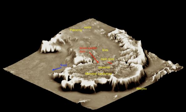
Figure 2:- Textured 3D model of Bolaven Plateau View north, with the Xe Pian Xe Namnoy project shown at the bottom edge of the lava field. Vertical scale exaggerated. See text for technique used.
.
If effectively dammed, the network of narrow canyons on the older rocks on the southern part of the plateau provides some limited reservoir storage. More recent volcanism has partially filled some of the lower reaches of these canyons with lava flowing from surface vents flooding down from the north. The high secondary permeability of lava and possibly the residual laterite soils that form on it lead to sink drainages. This in turn results in groundwater flows toward the edges of the plateau, and where at points downslope these flows converge and rise, surfacing of groundwater flow creates a dendritic pattern of canyons cut into the easily weathered basalt lavas. At the edge of the plateau, the groundwater feeds notable seasonal waterfalls. At the upstream margins of the lava flows, remnants of weathered basalt form surficial canyon blockages that appear to be topographically favorable for dams but are deeply weathered to typical lateritic tropical soils. It now appears that this assemblage presents potentially unstable foundation conditions for dams.
The first author developed an interest in the failure as a result of having once in the 1960s participated in the design and construction of a problematical dam at a site with similar geological conditions but located on the uplifted southern rim of the Korat Plateau 500 km to the west. That dam was American designed based on experience with many projects in the western US but reflected lack of experience with tropical geology. The result was a near accident similar to the 2019 saddle dam failure.
With this interest and background, following the 2018 failure the first author made application for access to data on the Xe Pian Xe Namnoy project. But the Lao government and the Thai and Korean investors and engineers involved had quickly imposed a general blackout on all information on the project that continues even today in mid 2019, a year after the failure, even as the reservoir, with partial repairs, is now reportedly scheduled for refilling to recover financial goals of the $ 1 billion investment.
Initial simplified diagnosis of the failure was facilitated by a Google Maps terrain view of the site (15.008, 106.653) which shows a sink drainage above the dam. Details are shown in the author’s diagnosis above but can be replicated in a minute or two by the reader by entering those coordinates in a web browser and setting Google Maps to terrain view.
Access to the failure site has been prohibited but regional geologic mapping developed cooperatively by Lao and Japanese geologists is available. A clearer picture of the local physical geography emerged via scalable textured visualizations including the geological mapping and combined with SRTM and ALOS (approximately 2005) satellite data. Such a representation is shown here for the Bolaven Plateau, figure 2. The model was developed in QGIS and exported for 3-D visualization to Blender. The surface texture was processed by applying a high pass filter to the same terrain data and draping it as a brown-and-white image onto the 3-D manipulatable Blender model with exaggerated vertical scale. This preserves the texture of the local topography, making it relatively easy to discern between rough old sandstone, to the south, and smooth lava flows, to the north. Figure 3 shows a closer view of the same terrain model with project reservoir, dams, and mapped geology distinguishing Mesozoic sedimentary rocks from overlying lava flows.
With project data remaining secret additional important geologic and hydrologic data were needed and found in various Japanese studies undertaken initially in the early 2000 decade in connection with bauxite exploration and for several proposed dam sites, all of which are located on the margin of the lava flows and all questioned as to suitability, probably because of the low ground water and high seepage potential of the basalt. Among those sites so identified and proposed was a site for the main dam of the Xe Pian Xe Namnoy project; investigations demonstrated some problems including one basalt abutment with a low groundwater table and high seepage potential verified by borehole pressure tests. The final dam site was subsequently shifted upstream to its present location presumably to avoid these conditions. All of this information is available in online reports by the Japanese aid agency and served to make a possible diagnosis without specific detailed site investigation data at Xe Pian Xe Namnoy, assuming such data even exist.
A closer view of the portion of the reservoir including the main and three saddle downs is shown in Figure 3. The area mapped as basalt by Japanese and Lao geologists is indicated in by purple shading and is a good match with the geology pattern inferred from the terrain texture modeling described above. The upper reaches of the lava at about elevation 850 m form 10 km of the rim of the reservoir.

Figure 3: Close-in view of textured terrain model at dam sites. Note the purple lobe of lava which forms 10 km of the reservoir rim requiring saddle dams to achieve the billion cubic meters storage needs. Lava also found downstream of the main dam, with its properties well defined by Japanese studies.
.
The inferred evolution of the terrain at the failed saddle dam site is shown in graphic sketches (Figure 4):-
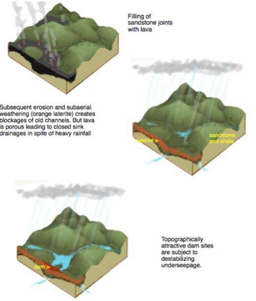
Figure 4: Thevolution of landscape at edge of a lava flow
.
With 3000 mm of annual summer rainfall it is evident that the underlying basalt was always able to convey a substantial subsurface flow beneath the saddle dam site, opportunistically located on a remnant basalt/laterite ridge lacking development of surface drainage. Here as at the other dams at Xe Pian Xe Namnoy and at yet more dam sites proposed for the Bolaven Plateau, the flow of groundwater in the basalt passes toward the edge of the plateau (in this case to the southwest), eventually emerging to the surface and creating dendritic pattern of incised canyons that is quite different from the trilinear joint pattern seen in the Mesozoic rocks.
The Japanese engineering geologists in their investigations have identified lava cooling joints as principal seepage paths, but other conditions promoting high and concentrated subsurface flow and erosion including those that might be associated with hot lava flowing in wet jungle canyons — volcanic tubes, brecciated zones, perhaps maar-like features, as well as uncompressed or open stress relief joints in the underlying sandstone can be readily proposed. Runoff deficits from sink areas including at the saddle dam site are quite large, consistent with experience elsewhere with losing streams in lava areas. Borehole water pressure tests taken at various of the rejected other sites on the plateau indicated high flows often exceeding the pumping capacity of the equipment.
A telling pair of photos of the dam crest a few hours before failure is shown in Figures 5a and 5b:-
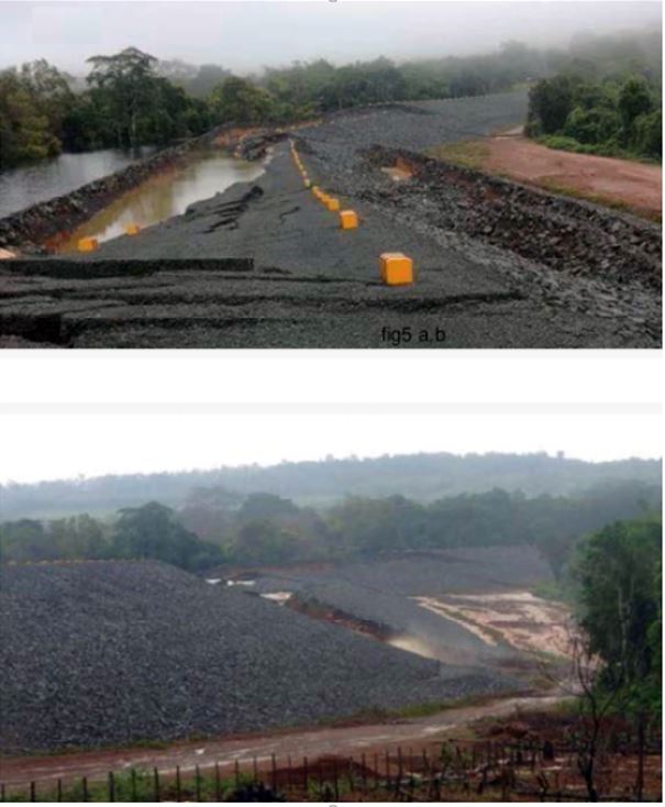
Figure 5:- News photos of saddle dam at Xe Pian Xe Namnoy hours before failure.
.
Both downward and lateral deformation of the dam are evident. The first author’s sketch of one of the hypotheses of the generation of this failure pattern is shown on figure 6. Note that the dam embankment does not include any drains or zoning that would protect against seepage failure of the embankment or relieve foundation water pressures. Alternative or complementary foundation seepage paths including eroded tunnels and cavities developing probably at the top of the basalt or between the laterite and basalt, or the basalt and the upper sedimentary rocks can also be imagined. Unprecedented uplift pressures beneath the cap of laterite developed. A large component of ground slippage toward the drone camera, i.e. away from the abutment, is suggested in figure 1. The general concept of a seepage induced foundation failure was initially advanced by the writer in October 2018 three months after the failure. The official government expert panel reportedly came to the same findings, but this report has never been released, reportedly out of deference to the Korean government.
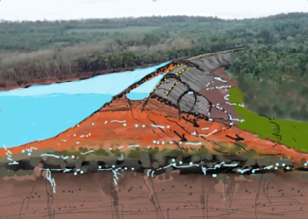
Figure 6: A sketch of failure hypothesis for the Xe Pian Xe Namnoy saddle dam.
.
A more ominous scenario for the 2018 failure involves the partial mobilization of the ridge area at and downstream of the left abutment of the dam along with a simultaneous failure at the saddle dam. This possibility is suggested both by the canyon-facing scarps in Figure 1 and also by the presence of a separate landslide on the left side of the canyon on ground not directly impacted by the saddle dam (Figures 7 and 8):-
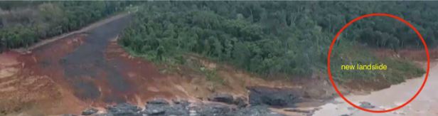
Figure 7:- A landslide downstream from the Xe Pian Xe Namnoy dam failure, which is unconnected to the dam.
.
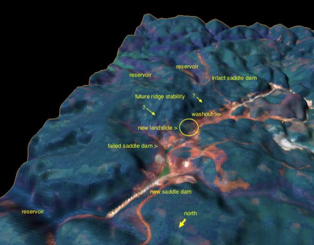
Figure 8: Potential instability of intact saddle dam and ridge area at Xe Pian Xe Namnoy . Post-failure satellite image draped on a 3D terrain model.
.
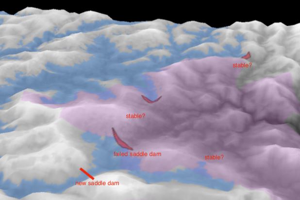
Figure 9: Textured terrain model showing potential instability in the high levels of weathered lava. Choice of a site for the new saddle dam that presents sandstone abutments suggests an awareness of the doubtful stability of basalt lavas.
.
Reportedly all of the saddle dams are to be replaced by new roller-compacted concrete dams. But adequate stability of the other two saddle dam foundations would surely need to be verified to allow this, considering the precedent of the famous 1928 St. Francis Dam failure. That too was taken to be superior in strength by virtue of its being made from concrete. But the St. Francis dam was fatally sited on a weak and weathered foundation (Figure 10). This case history renders the reported plan, if true, for construction of “strong” concrete dams on weak lava-derived foundations highly questionable.
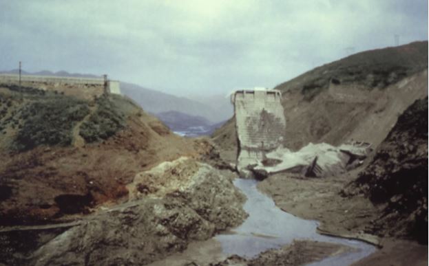
Figure 10: Remains of the concrete St. Francis dam built on weathered foundation rocks.
.
If, as mapped by the Japanese mining geologists, and suggested as well by the textured 3D models, the 10 km southwestern rim of the reservoir is underlain by deep laterite soil, leaky basalt, and weathered sedimentary rocks, the suitability of concrete dams must be considered. Moreover, a pattern of unstable ground could extend widely beneath the entire ridge between the reservoir and the canyon below the failed saddle dam. Generalized landslide slope failures along this ridge can be suspected from photographic evidence as shown in Figure 9. Immediate failure of the ridge might not occur because time would be required following filling of the reservoir to raise the water table to critical levels. A major failure of the ridge could be a greater catastrophe than the 2018 failure.
The severe social impact of the project and its failure last year have received censure from the UN and other parties. As of mid 2019 the viability and future of the Xe Pian Xe Namnoy project remains uncertain.
Richard Meehan and Douglas Hamilton. All views expressed are those of the authors.
9 September 2019
The impact of the 2017 Mocoa debris flows
The impact of the 2017 Mocoa debris flows
The 2017 Mocoa debris flows in Colombia, which resulted in the deaths of 409 people, were the worst landslide disaster in that country for some years. I wrote about the tragedy at the time, and have also highlighted an article published earlier this year investigating the causes and effects of this rainfall induced disaster. A new paper has been published in the journal Landslides (
First,
Second, t
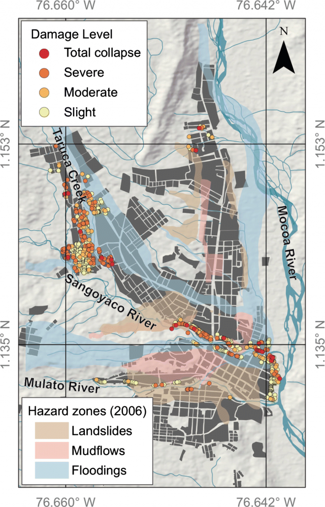
The damage to structures caused by the 2017 Mocoa debris flows. The shading indicates the 2006 hazard map that formed the basis for land use planning. Map from Prada-Sarmiento et al. (2019).
.
As observe:-
“In terms of damage, we can see that the hazard zoning strategy defined prior the event correctly identified several areas in which flooding and mudflows took place. However, it must be highlighted that this strategy does not explicitly consider large debris flows, which were responsible for most of the casualties and damage caused by the 2017 event. This analysis clearly reveals a need to incorporate good-quality information about multiple hazards in the municipal land used plans and the design of consequent mitigation strategies.”
This is a lesson that applies in many other places. The town is now protected by an early warning system, which reportedly performed well in the 2018 event, and will hopefully prevent a repeat of the 2017 Mocoa debris flows.
Reference
Prada-Sarmiento, L.F., Cabrera, M.A., Camacho, R. et al. 2019. The Mocoa Event on March 31 (2017): analysis of a series of mass movements in a tropical environment of the Andean-Amazonian Piedmont. Landslides. https://doi.org/10.1007/s10346-019-01263-y.
6 September 2019
Veslemannen in Norway – major movement, and possibly a significant failure, reported
Veslemannen in Norway – major movement, and possibly a significant failure, reported
Over the last few days, the Velsemannen rockslide in Norway has undergone another major movement event. This large rock mass has undergone repeated movement events in recent years, responding in particular to phases of wet weather when the ground is not frozen. There has been a substantial impact on the local community – the 11 residents in the valley below the Velsemannen rockslide have been evacuated on 16 separate occasions over the last five years as movement crises have developed.
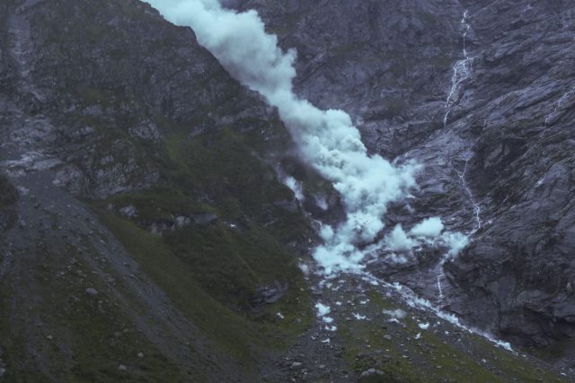
This time though the events are clearly different. Yesterday (Thursday 5th September) the landslide showed movement rates far higher than had been recorded previously, with the lower part of the rock mass reportedly moving 70 cm. In comparison, the mass moved a total of 58 cm in the whole of 2018. Rockfalls were repeatedly observed on the unstable mass, a sign that it was undergoing internal deformation and fracturing:-
A rockfall from the Velsemannen rockslide on 5th September 2019. Image from vg.no
Overnight Thursday and into early Friday a large failure appears to have occurred. News reports suggest that this might be in the order of 100,000 cubic metres, although more analysis is clearly needed to validate these numbers, and that the initial visual inspection indicates that a major part of the unstable mass has now failed and collapsed. Pleasingly, the properties at the foot of the slope do not seem to have been impacted so far.
Forecasting the behaviour of Velsemannen has been extremely challenging as the rockslide has gone through repeated movement crises, without accelerating to final failure. A collapse event was inevitable, such that evacuations were essential, but the behaviour has been extremely unpredictable. The best case scenario appeared to be a collapse event in a series of smaller failures, preventing the long runout that would have destroyed the properties. So far, his appears to have been the outcome.
Work will now be needed to monitor the remaining unstable rock mass, and to determine its susceptibility to a collapse. We have seen elsewhere that an initial event can sometimes trigger a further large failure. But for the people living below Velsemannen, and for the geologists, this must be a major step towards resolving the problems.
4 September 2019
A global database of giant landslides on volcanic islands
A global database of giant landslides on volcanic islands
In a paper just published in the journal Landslides, et al. (2019) describe the compilation of a new global database of giant landslides on volcanic islands. This database is hosted on the website of the Institute of Rock Structure & Mechanics. The authors note that “the records can be downloaded as a spreadsheet or as a kml file for interrogation in a number of geospatial software programs including ArcGIS and Google Earth“.
The dataset contains records of landslides with a volume in the order of cubic kilometres (a cubic kilometre is 1 billion m³). The records are limited to landslides occurring on purely volcanic islands (i.e. not those formed through a combination of volcanic and other processes). The hazards posed by these giant volcanic landslides are well documented (and are sometimes somewhat hyped), but the authors note that our understanding of these types of failures remains inadequate.
In total, the database contains 182 landslide records, with the distribution as below:-
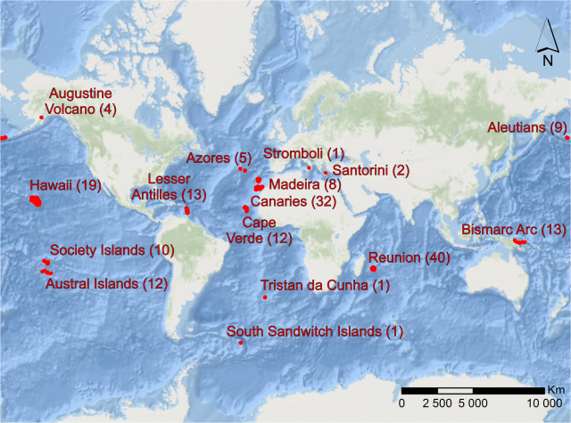
The distribution of records in the global database of giant landslides on volcanic islands. Image from Blahůt et al. (2019)
.
These landslides can be truly vast. The median length of the landslides is 59.4 km, and the median surface area is 880 km². However, Blahůt et al. (2019) describe the Nuuanu debris avalanche on Oahu, Hawaii, which has a length of 270 km and a surface area of 29,241 km². This extreme size is expressed in the graph below, showing length against volume, for the entire dataset:-
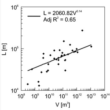
The relationship between landslide length and volume for the 182 records in the global database of giant landslides on volcanic islands. Graph from Blahůt et al. (2019).
.
As usual, the general trend is that length increases with volume, but note the extreme size of the events at the higher end of the range of scales.
Finally, Blahůt et al. (2019) note that more than half of the events in the dataset are known to have occurred in the last 500,000 years, which in geological terms is brief. There is a little doubt that many, many more landslide deposits must be sitting in the submarine sedimentary record. Thus, with time it is likely that the database will expand.
Reference
Blahůt, J., Balek, J., Klimeš, J. et al. 2019. A comprehensive global database of giant landslides on volcanic islands. Landslides. https://doi.org/10.1007/s10346-019-01275-8
3 September 2019
The tyranny of dozer road building
The tyranny of dozer road building
As the 2019 summer monsoon starts to wind down across Nepal, two newspapers have published well-considered articles examining the disastrous effects of so-called dozer roads. These are new roads, built in rural areas, with the use of bulldozers but essentially no engineering. One article, by Dane Carlson in The Himalayan Times, provides a greater articulation of the problem:
“Dozer road building usually comes along with a near-total absence of proper drainage, haphazard destruction of wide swathes of vegetation, and reckless downhill soil dumping. This is a human and environmental disaster underway in plain sight. The current upward trend in dozer road building across the country indicates the steady, if not exponential, growth of this disaster.”
The same article describes the conundrum:
“Road building is now ubiquitous across Nepal, from Kathmandu to the most remote corners of the country. Every Nepali deserves access to a road and the vital services that come with it: education, medicine, access to new markets, and easy transport to urban centres. Road building and maintenance bring paid work, especially needed in remote communities. Nobody would argue against the importance of these outcomes.
“But roads aren’t the development cure-all that many pretend they are. Just as ubiquitous as road building in Nepal is the destruction that accompanies it: if you’re travelling in the hills and want to find a road, just look for the landslides. The vast majority of Nepal’s local road network is cut haphazardly into steep hillsides with little or no planning, triggering landslides and washing massive amounts of soil into rivers.”
The practice of dozer road building is widespread and massively destructive. Astonishingly, the article notes that “from 1998 to 2016, the length of Nepal’s road network multiplied by a factor of 11“.
Meanwhile, The Kathmandu Post describes the effects of this blizzard of road building in one district, Baglung:-
“In Baglung Municipality too roads get swept away every year by landslides. Gyanendra Gautam, ward chairman of Baglung Ward No 11, said that most of the rural roads have been swept away by landslides in this monsoon. “Forget vehicles, even people can’t walk through these rural roads,” said Gautam.”
I have written previously about the disastrous effects of these dozer roads in Nepal. The Google Earth image below, from Badigad in Nepal, shows the scale of the problem:-
A Google Earth image from Badigad in Baglung, Nepal, showing the scale of landslides associated with Dozer roads
.
This pattern is repeated endlessly across the Hill Districts of Nepal, and the problem is getting worse, quickly. The irony is of course that in many cases, the local population ends up being worse off a few years after the road has been built. As Dale Carson writes:
“Roads and the services they provide are needed. But the current trajectory of road building trades short-term benefits for widespread long-term problems. And, like many disasters, these will be driven by the actions of the wealthy and powerful few to the detriment of the many.”
This is an avoidable environmental and human tragedy.
 Dave Petley is the Vice-Chancellor of the University of Hull in the United Kingdom. His blog provides commentary and analysis of landslide events occurring worldwide, including the landslides themselves, latest research, and conferences and meetings.
Recent Comments