
19 September 2019
Mine waste landslides at the Kumtor Goldmine in Kyrgyzstan
Posted by Dave Petley
Mine waste landslides at the Kumtor Goldmine in Kyrgyzstan
In the course of some work that I’m undertaking on human-induced landslides, I have come across an interesting article (Torgoev and Omorov 2014 – available online) about landslides at the Kumtor Goldmine in Kyrgyzstan (location = 41.868, 78.169). This site is unusual as the mining is being undertaken at an unusual elevation, 3,000 – 4,400 metres above sea level, at a site that has active glaciers. The mining waste is being dumped into a glaciated valley, allowing the development of a large landslide. Fortunately this is slow-moving compared with many other mine waste landslide events. The site can be seen in the Google Earth image below, collected in August 2016. I have marked the toe of the landslide:-
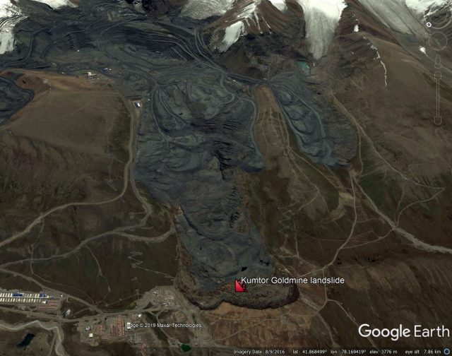
A Google Earth image of the Kumtor Goldmine landslide.
.
Torgoev and Omorov (2014) observe that by 2013 about 1 billion tonnes of mine waste and 100 million tonnes of glacial ice had been removed from the Kumtor Goldmine, and dumped in the valley. Most of the waste was dumped onto active glaciers, primarily the Davydor Glacier. This has triggered movement that is a strange hybrid of glacial flow and a landslide, although as the image above shows, the current morphology is primarily that of a mine waste landslide.
The largest landslide (but note that there are others at the site), has a volume of about 70 million m³, and a total movement distance of about 3 km based on the Google Earth image. Torgoev and Omorov (2014) report that it is about 85 metres thick, and is moving on a surface with a gradient of about 5°.
Fortunately, the rate of movement of these dumps is quite low compared with many other mine waste landslides. Geodetic data presented in the paper indicates movement rates in 2012 of about 1.5 metres per day, although a higher movement rate event was recorded in April 2013, when rates reached 5.3 metres per day. This caused the loss of some buildings:-
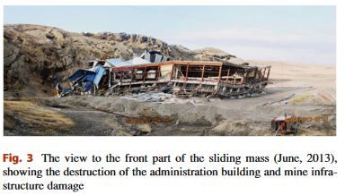
Building damage caused by the Kumtor Goldmine landslide in Kyrgyzstan. Image from Torgoev and Omorov (2014).
.
The landslide at the Kumtor Goldmine continues to move. This image is a Planet Labs PlanetScope image from 11th August 2019. I have rotated it to allow easier comparison with the Google Earth image above:-
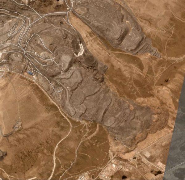
A Planet Labs PlanetScope image of the Kumtor Goldmine landslide, dated 11th August 2019. Image copyright Planet Labs, used with permission.
.
This image suggests that the landslide has continued to advance, probably more slowly than previously, whilst the toe of the landslide has started to spread laterally. The toe of the landslide appears to consist primarily of material entrained into the slide from the slopes below the dump.
This is an unusual and interesting hybrid mine waste landslide. I wonder how its dynamics might change as global heating induces temperature rises (and thus thawing of the ice) in the landslide mass.
References
Torgoev, I. and Omorov, B. 2014. Mass Movement in the Waste Dump of High-Altitude Kumtor Goldmine (Kyrgyzstan). In Sassa K., Canuti P., Yin Y. (eds) Landslide Science for a Safer Geoenvironment. Springer.
Planet Team (2019). Planet Application Program Interface: In Space for Life on Earth. San Francisco, CA. https://www.planet.com/
 Dave Petley is the Vice-Chancellor of the University of Hull in the United Kingdom. His blog provides commentary and analysis of landslide events occurring worldwide, including the landslides themselves, latest research, and conferences and meetings.
There is another interesting paper on this site by:
Jamieson, S.S.R., Ewertowski, M.W., Evans, D.J.A., 2015. Rapid advance of two mountain glaciers in response to mine-related debris loading. Journal of Geophysical Research – Earth Surface.
https://agupubs.onlinelibrary.wiley.com/doi/full/10.1002/2015JF003504
I particularly like the time-lapse imagery in the supplementary material.
The 2015 paper by Jamieson et al. talks in detail about the impacts of loading sediment onto the ice: https://agupubs.onlinelibrary.wiley.com/doi/full/10.1002/2015JF003504
I wonder if adding a load on top of a glacier would increase its rate of movement due to pressure melting or the simple expedient of compressing it. I am thinking of a process similar to salt diapir deformation.