
2 September 2019
The landslide-induced train derailment at Lock Eilt in Scotland in January 2018
The landslide-induced train derailment at Lock Eilt in Scotland in January 2018
On 22nd January 2018 a train was derailed by a landslide at Loch Eilt in north-west Scotland, fortunately with no loss of life. The image below shows the aftermath of the event:-
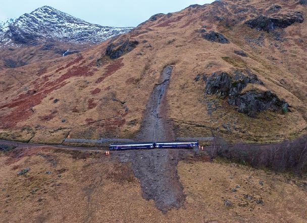
The aftermath of the train derailment at Loch Eilt in Scotland on 22nd January 2018. Image from the RAIB report into the incident.
.
A few months later the Rail Accident Investigation Branch published a report, available online, into the accident. The report is well-written, providing a very clear narrative about the events on the day. It found that the landslide occurred as a result of rapid thaw after a period of cold weather, which in turn followed a phase of wet weather. Thus, the ground was saturated and frozen, with some snow cover. The increase in temperatures released substantial amounts of water, triggering the landslide.
Of particular interest is the presence of the catch fence, which was overrun by the landslide debris, as shown in the image below, also from the RAIB report:-
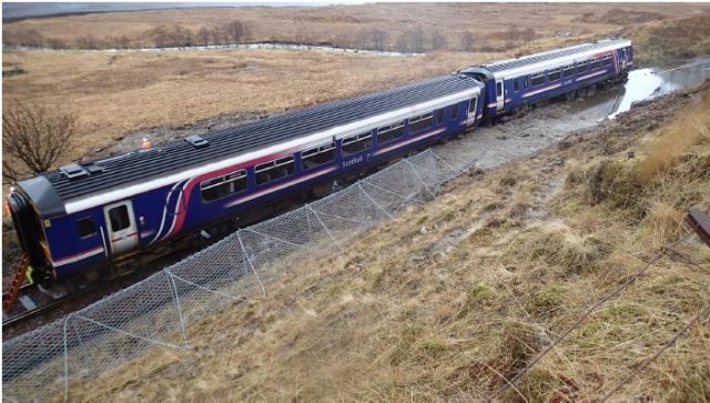
The damaged catch fence at Loch Eilt in Scotland on 22nd January 2018. Image from the RAIB report into the incident.
.
The UK has a byzantine structure for running the railways, with the track being managed by a not for profit, government-owned entity called Network Rail, which is separate from the train operators. In 2015, Network Rail commissioned a consultant to examine the slopes in the Lock Eilt area, with an initial focus on rockfalls and boulder incursions, but with a subsequently expanded remit to include minor landslides originating from beyond the railway boundary. This study concluded that there was a risk of boulder incursion at this point; the catch fence was constructed to capture such events. The RAIB report indicated that in tests the fence design had successfully retained a 3 tonne boulder travelling 30 m down a 35° slope.
The landslide itself had a volume of between 500 and 600 m³, and thus has a mass of over 1000 tonnes. The landslide scar extended 80 m beyond the railway boundary, with a height difference of 46 metres. As such, the fence could not be expected to retain this landslide.
The event illustrates the difficulties of assessing the type of failure that might occur at a given location, even when the slopes are known to be potentially unstable. Mitigation works depend on this assessment to be effective, but the range of failure types is so complex that undertaking these assessments is a major challenge. Network Rail, and its consultants, have to manage over 16,000 km of railway track in the UK, much of which sits adjacent to slopes. The magnitude of the task is clear, especially as the slopes become more vulnerable to failure as a result of climate change.
22 August 2019
Reports of multiple fatal landslides in the Wenchuan area of China
Reports of multiple fatal landslides in the Wenchuan area of China
Various news agencies in China are reporting multiple landslides triggered by extreme rainfall in the Wenchuan area, and adjacent regions, of China. Xinhua has a fairly basic report, with some images. More detail is provided by a report by ECNS:
Nine people were killed and 35 were missing after multiple mudslides struck Aba Tibetan and Qiang autonomous prefecture in Sichuan province on Tuesday, local authorities said.
In Wenchuan itself, ECNS reports:
At least one firefighter was dead and three people were reported missing after multiple mudslides hit Wenchuan County, southwest China’s Sichuan Province, local authorities said.
At least four people were dead and 11 were reported missing in Wenchuan County after multiple mudslides happened following heavy rainfall. Seven people were missing and 60 were trapped in Wolong special administrative zone in the county.
Gengda Township in Wolong appears to be singled out as having been badly affected, albeit little real detail is available as yet. This image, via ECNS, is from Gengda township:-
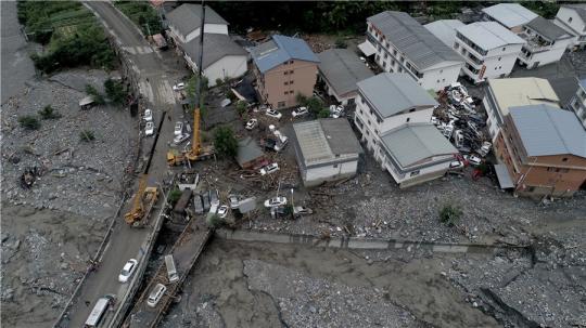
The aftermath of a debris flow in Gengda township, Wenchuan. Image via ECNS, credit: LIU ZHONGJUN/FOR CHINA DAILY.
Meanwhile this image from ECNS shows the aftermath of a debris flow in Banquio village in Sichuan:-
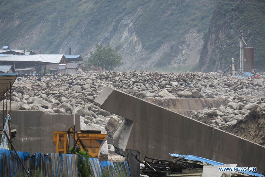
An image of the aftermath of a debris flow in the Wenchuan area of China. Image via ECNS
.
This area was, of course, severely affected by the 2008 Wenchuan earthquake, with disastrous consequences. The mountains have continued to be very seriously impacted by landslides since then, with significant losses occurring most years. In a recent paper on this event, Fan et al. (2018) noted that:
Although the slope self-healing process (grain coarsening, consolidation, revegetation) does rebalance the rainfall threshold to that of a pre-earthquake level, the debris flow activity has not yet reached the pre-2008 background levels.
It appears that this situation continues.
Reference
Xuanmei Fan, C. Hsein Juang, Janusz Wasowski, Runqiu Huang, Qiang Xu, Gianvito Scaringi, Cees J. van Westen, Hans-Balder Havenith. 2018. What we have learned from the 2008 Wenchuan Earthquake and its aftermath: A decade of research and challenges, Engineering Geology, 241, 25-32. https://doi.org/10.1016/j.enggeo.2018.05.004. (https://www.sciencedirect.com/science/article/pii/S0013795218307233)
21 August 2019
The Kavalappara landslide in the western Ghats of India
The Kavalappara landslide in the western Ghats of India
At 7:30 pm on 8th August 2019 the large the Kavalappara landslide in Wayanad, part of the western Ghats in Kerala, India buried a small community. Whilst rescue operations continue, it has been reported that 46 bodies have been recovered from the debris, whilst it is believed that a further 13 people were killed. The landslide was triggered by a period of intense monsoon rainfall. The Indian Express has some details about the precipitation event that initiated the landslide:
Malappuram meteorological subdivision got 189.4 mm rain from August 1 to August 7, 66% more than the normal 114.3 mm. On August 8, the Nilambur rain gauge station, the one nearest to Kavalappara, recorded the highest rainfall of that day in Kerala.
Indian Express also has this image of the landslide, which appears to have been both large and mobile:-
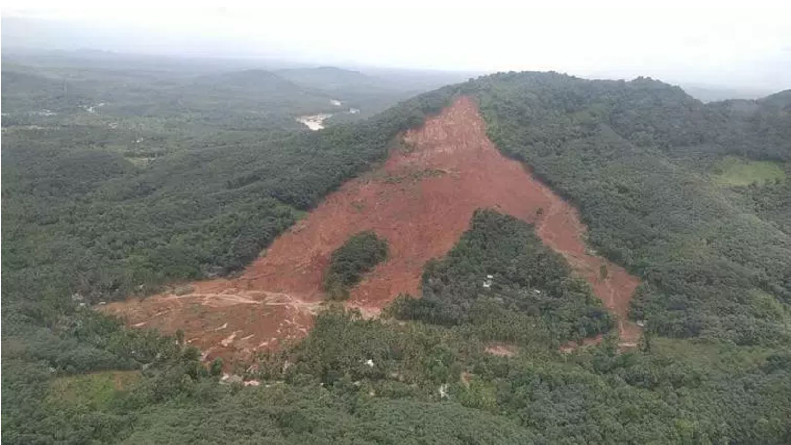
The 8th August 2019 The Kavalappara landslide, which killed 59 people. Image via the Indian Express.
.
Meanwhile, the Deccan Chronicle has a different perspective on the landslide:-
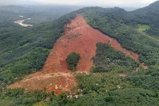
The 8th August 2019 Kavalappara landslide in the Western Ghats of India. Image via the Deccan Chronicle.
.
The deep red soils indicate a high degree of weathering. The upper quarter of the landslide source appears to have exposed bedrock, perhaps suggesting that the initial failure occurred on the interface between weathered and intact rock. This portion of the slide surface appears to be much steeper than the rest of the landslide source. The lower three-quarters of the landslide source appear to be situated in weathered soils or regolith. Note that the flow bifurcated into three streams, presumably controlled by the underlying topography. This has left an undisturbed island of trees, which is reminiscent of the Pingdi landslide in China that I highlighted yesterday. The other flow path has cut a separate track.
The heavy rainfall that triggered this landslide caused widespread damage. At Puthumala, also within Wayanad district, 17 people were killed when 53 houses, a mosque, a temple and a shop were buried by another large landslide.
20 August 2019
A high resolution Planet Labs image of the Pingdi landslide in China
A high resolution Planet Labs image of the Pingdi landslide in China
The 23rd July 2019 Pingdi landslide in Shuicheng County in the city of Liupanshui in Guizhou Province, China is thought to have killed 51 people. This was a large, complex landslide associated with heavy rainfall. As is usual in China, after the initial reports of the losses and the heroic acts of the rescuers, little information has emerged as to the causes of the landslide. We can expect that it will be analysed in a research paper in due course, but this is unlikely to emerge for a year or so.
Planet Labs have however captured a high quality satellite image of the site, which they have kindly made available to me. Once again I am indebted to Rob Simmon for his help with this. The image was captured on 2nd August 2019:-
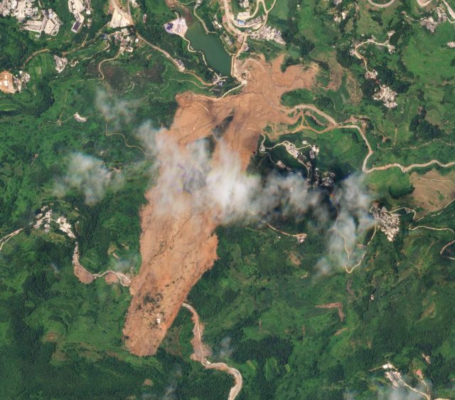
A Planet Labs SkySat image of the Pingdi landslide in Guizhou Province China. Image collected on 2nd August 2019, copyright Planet Labs, used with permission.
.
There are aspects of this landslide that are interesting:
- The road crossing the upper part of the landslide is clear. I have previously suggested that this may have played a role in the initial failure. Note the apparent fresh cuts on the upslope side of the road, suggesting recent widening. It is clear that a number of these cut slopes have also undergone small scale failures. I continue to wonder if this road may have been a key part of the failure process;
- There appears to be a number of other smaller-scale failures located in the vicinity of the landslide. This may indicated very localised, extreme rainfall;
- The runout behaviour of the toe of the landslide is quite complex, as this part of the image shows:
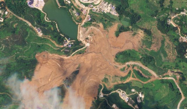
A Planet Labs SkySat image of the toe of the Pingdi landslide in Guizhou Province China. Image collected on 2nd August 2019, copyright Planet Labs, used with permission.
.
Further up the slope the landslide track bifurcated and then recombined before running out. On the right side of the images parts of the landslide debris have entered and followed existing channels, in one case crossing and blocking another road, To me this suggests quite high mobility.
Reference and acknowledgement
Thanks to Robert Simmon for his help in acquiring and processing the image.
Planet Team (2019). Planet Application Program Interface: In Space for Life on Earth. San Francisco, CA. https://www.planet.com/
8 August 2019
The South Tahoma Glacier/Tahoma Creek Outburst Flood & Debris Flow on 5th August 2019
The South Tahoma Glacier/Tahoma Creek Outburst Flood & Debris Flow on 5th August 2019
With thanks to Scott Beason, Park Geologist, Mount Rainier National Park.
On Monday evening, 5th August 2019, an outburst flood and debris flow occurred at Mount Rainier National Park. Between approximately 6:48 – 7:58 PM PDT (8/6/2019 01:48 – 2:58 UTC), the park’s seismographs picked up four separate debris flow sequences in the Tahoma Creek area. Scott notes that:
“On arrival in the park on Tuesday morning, I observed extreme sediment transport/hyperconcentrated flows at the road bridge, approximately 13 km downstream of the glacier. Once I got in the office, I checked the seismic records and saw a clear debris flow signature (see below). After checking with the USGS/Cascades Volcano Observatory, who concurred on the debris flow signature, we closed the park’s West Side Road (which parallels Tahoma Creek and is downstream of the South Tahoma Glacier) until we could undertake a ground and aerial reconnaissance to determine the source and additional hazards”
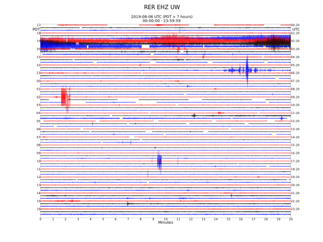
The seismogram record that captures the Mount Rainier Debris Flow. Provided by Scott Beason. Data from Pacific Northwest Seismic Network (PNSN) and USGS/Cascade Volcano Observatory.
.
Seismic data shows that the debris flows had four discrete pulses (see the earthquake spectra image and seismic records below) and Scott has found numerous debris flow levees and boulder fields in the field.
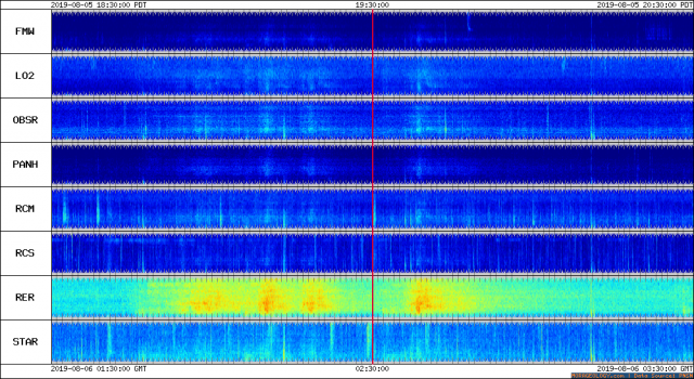
The earthquake spectra for the Mount Rainier debris flow event. Image provided by Scott Beason. Data from Pacific Northwest Seismic Network (PNSN) and USGS/Cascade Volcano Observatory.
.
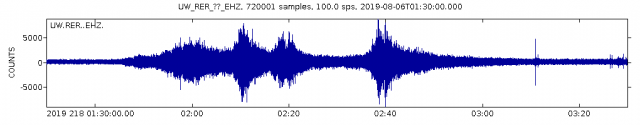
Detailed seismic record for the Mount Rainier debris flow event. Image provided by Scott Beason. Data from Pacific Northwest Seismic Network (PNSN) and USGS/Cascade Volcano Observatory.
.
Scott and his colleagues were able to collect images of the aftermath of the event via a helicopter flight and fieldwork. These are available via a Flickr page – they are fabulous:-
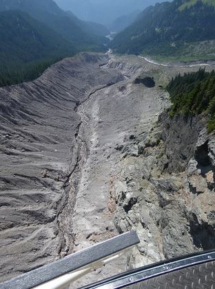
The bulking zone of the Mount Rainer debris flow, Image by Scott Beason via Flickr.
.
Initial satellite image analysis by Scott suggests that the outlet stream from the South Tahoma changed locations:-
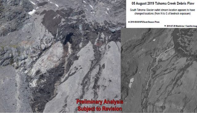
An initial analysis, by Scott Beason, of the source of the Mount Rainier debris flow.
.
Scott’s initial hypothesis that this was a catastrophic change that then rapidly incised into debris-covered stagnant ice and ground-cored moraine just downstream and between bedrock “steps” below the glacier. Once it had enough momentum, it then rapidly bulked up into little ice age ground moraine several km’s below the terminus. The run out ended about 6.5 – 7 km’s downstream where the boulder fields were deposited.
Interestingly, this event is remarkably similar to the 2015 debris flow sequence.
There is much more to write about this event, and I will return to it in the next few days. In the meantime, many thanks to Scott for highlighting it to me, and for the amazing data.
Wow!
7 August 2019
Deviot, Tasmania: the impact of a slow moving landslide on home owners
Deviot, Tasmania: the impact of a slow moving landslide on home owners
In Australia today, news agencies are reporting a dispute between the government and home-owners over the impact of a reactivated, slow-moving landslide. The location is Deviot in Tasmania, where a landslide is slowly destroying five properties. It is a common, and extremely sad story of the impact that a landslide has had on everyday lives.
The location is -41.226, 146.924 – there is good Google Earth imagery of the site, taken in early 2016:-
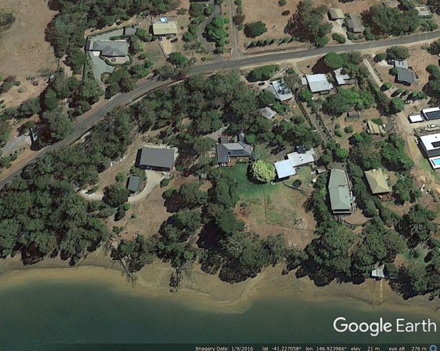
The site of the landslide at Deviot in Tasmania. Imagre via google Earth, collected in January 2016.
.
In 2013, during a period of heavy winter rainfall, the landslide at this site in Deviot reactivated, causing structural damage to a house. Further significant damage occurred in 2016, with the movement affecting five houses. At least one has had to be demolished. Such an event is usually a disaster for the property owners, as in most jurisdictions domestic insurance does not cover landslide damage. The level of impact of the landslide is dramatic:-
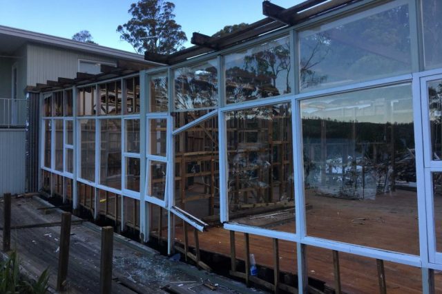
Structural damage caused by the Deviot landslide in 2016. Image by Nick Daking (the property owner) via ABC News.
.
This story, which is far from unique, has come to prominence because the property owners allege that the local authority were fully aware of the landslides at this site, but failed to inform the property owners of the hazard. The situation is being considered in the Upper House of the Tasmania Government.
Interestingly, there is a detailed geotechnical report on the site online (NB PDF), written this year by a geotechnical consultant, Dr Derek Pennington. This includes a map, from 2011, which shows the extent of the relict (historic) landslide and the portion that has reactivated, causing the property damage:-
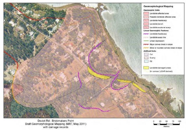
The 2011 MRT geomorphological map showing the Deviot landslide. Extracted from the report by Dr Derek Pennington.
.
The report also demonstrates that the landslide reactivated during unusually wet periods:
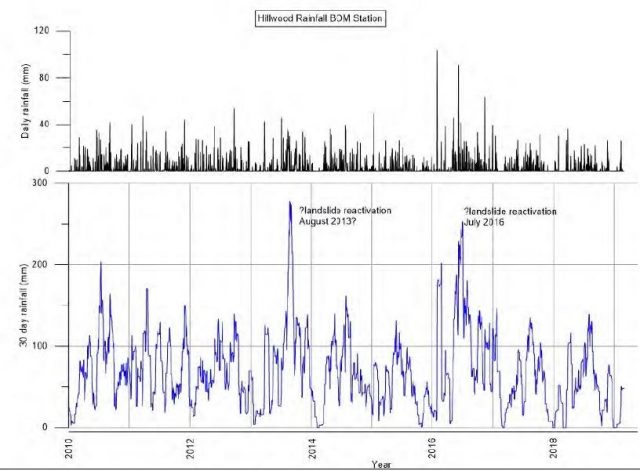
The rainfall record showing periods in which the Deviot landslide reactivated. Figure extracted from the report by Dr Derek Pennington.
.
This situation is a tragedy for the householders, who will have suffered huge financial loss and enormous stress. It is simply the case that an ordinary property owner cannot possibly anticipate this sort of hazard. Whilst I cannot really comment on the rights or wrongs of the case going before the parliament, we have to recognise that the system is not working correctly when potential property owners have no way to know that their site is at risk, and that there is no mechanism to insure against the risk. This needs to be addressed as it is occurs again and again around the world.
6 August 2019
July 2019: a record-breaking landslide month for fatal landslides
July 2019: a record-breaking month for fatal landslides
Yesterday, the European Union’s Copernicus Climate Change Service announced that July 2019 was the warmest month on record, continuing the long period of unsustainable global heating to which we are subjecting our planet. The statistics are stark – last month was 1.01 C warmer than the average July temperature between 1981 and 2010. The previous record was set in July 2016. The odds are strongly in favour of the new record being broken within the next few years.
Interestingly, last month I also recorded the highest monthly number of fatal landslides. Regular readers will know that I have been collating this data since September 2002, a dataset that is now approaching 17 years in duration. This has formed the basis of a number of papers over the years (e.g. Petley 2012), most recently with my post-doctoral researcher Dr Melanie Froude (Froude and Petley 2018). The data for the period 2004-2017 can be mapped using our online tool.
In 2019 I recorded a total of exactly 100 fatal landslides, breaking the previous record by a considerable margin. These landslides killed 358 people. By comparison, in 2018 I recorded just 51 fatal landslides, causing 148 fatalities. The graph below shows the cumulative total of fatal landslides, and the resulting deaths, for the year to date (correct as to 5th August 2019), but note that this data has not been subjected to the validation process that will allow it to be included in the main dataset as yet):-
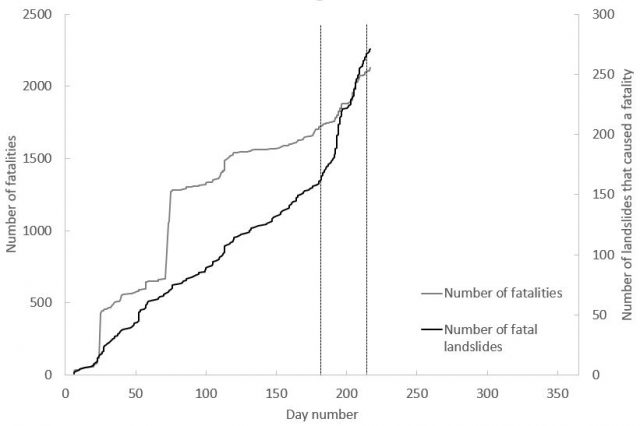
The cumulative graph for fatal landslides, and the resulting fatalities, in 2019 to date.
.
The black line is the number of landslides that I have recorded worldwide that have led to the loss of at least one life, whilst the grey line is the cumulative total of the number of resulting fatalities. The dashed lines indicate the start and end of July. The rapid acceleration in the number of fatal landslides at the start of the month is clear. This reflects the onset of the South Asian monsoon and is the normal pattern. However, the number of landslides recorded in unprecedented. In this period, there have been many landslides in South Asia (most notably Nepal, India and Bangladesh), but I have also recorded events in, for example, UK, Norway, USA, Myanmar, Tajikistan, Thailand, Guinea, Switzerland, Brazil, China and elsewhere.
At this stage it is not clear as to the cause of this surprising number of fatal landslides. It has long been suggested that increased global temperatures will lead to higher rainfall intensities (put simply, a warmer atmosphere can hold more moisture), and there is strong evidence that this is occurring. Most of the landslides in July 2019 were triggered by short duration, high intensity rainstorms. Whilst a single month does not prove the link by any means, July 2019 serves to illustrate once again the challenges that we will face in the future.
References
Froude, M. J. and Petley, D. N. 2018. Global fatal landslide occurrence from 2004 to 2016. Natural Hazards and Earth System Sciences, 18, 2161-2181, https://doi.org/10.5194/nhess-18-2161-2018.
Petley, D.N. 2012. Global patterns of loss of life from landslides. Geology 40 (10), 927-930.
5 August 2019
Grandview Surf Beach: a fatal rock topple in California
Grandview Surf Beach: a fatal rock topple in California
On Friday a small rock topple occurred on sandstone bluffs on Grandview Surf Beach in Encinitas to the north of San Diego, in California, USA. The topple appears to have occurred without identified precursors. Three people were tragically killed in this landslide. This image, from Channel News Asia, provides an overview of the event:-
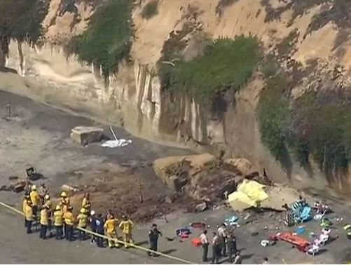
The rock topple at Grandview Surf Beach in California on 2nd August 2019. Image via Channel News Asia.
.
Reports indicate that the three victims were all women from the same family, who were local to the area.
The images above suggest that the failure mechanisms on these cliffs are quite complex, with rock toppling on the steep lower parts of the bluffs and shallow slips on the slightly lower angled upper sections. In this case the landslide appears to have been primarily the result of a large (some reports suggest about 10 m long) slab that underwent a toppling failure. Some of the debris from the upper part of the slope might also have been incorporated. This image, from Flipboard, gives a better sense of this failure event:-
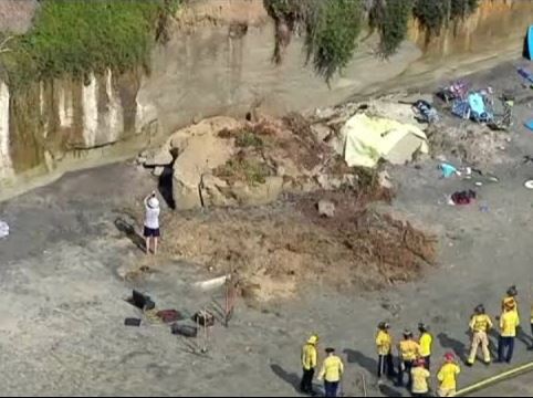
Overview of the aftermath of the rock topple at Grandview Surf Beach on 2nd August 2019. Image via Flipboard.
.
The images above both suggest that the sea erodes a notch at the foot of the cliff at this site (such a notch can be seen on the left side of the image above), destabilising the face of the cliff. This sets up a classic toppling scenario. Note that the sandstones that form this cliff have little jointing, a situation that allows larger slabs to form and that sets up failures that can be rapid and catastrophic.
Coastal cliffs can be dangerous. There often seems to be a presumption that rockfalls occur primarily in periods of poor weather. I am not sure that there is much evidence to support that assumption.
1 August 2019
Sogn og Fjordane: a series of large landslides in Norway
Sogn og Fjordane: a series of large landslides in Norway
Exceptional rainfall in both the United Kingdom and Norway have triggered substantial flood and landslide problems this week. In the UK, a large-scale evacuation remains in place as a result of the failure of the spillway of the Toddbrook Reservoir in Derbyshire. Efforts are underway to lower the reservoir level, but concerns remain that the dam could fail.
Meanwhile, in Norway record-breaking rainfall triggered a series of large landslides, primarily in Sogn og Fjordane county. One of these appears to have caused a fatality when a driver was caught in the flow at the foot of the slope at Årnes, with the car being swept into the Jølstravatnet lake. As yet the victim has not been recovered. Aftenposten has an article about this event, based upon the eye-witness report of a woman on the other side of the lake. It includes this image of the aftermath of the landslide:-
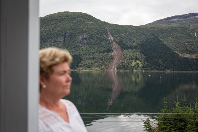
One of the landslides at Sogn og Fjordane in Norway on 30th July 2019. Image from Aftenposten.
.
Once again this appears to be a comparatively small failure on the upper slope, possibly consisting of a failure at the intact rock / regolith interface, which has then entrained slope material to become a debris avalanche.
Elsewhere, there was a series of similar failures. The most dramatic may well have occurred at Vassenden in Jølster, in which the landslide appears to have split the community in half. The image below is from NK, which has an excellent gallery of pictures of the landslides:-
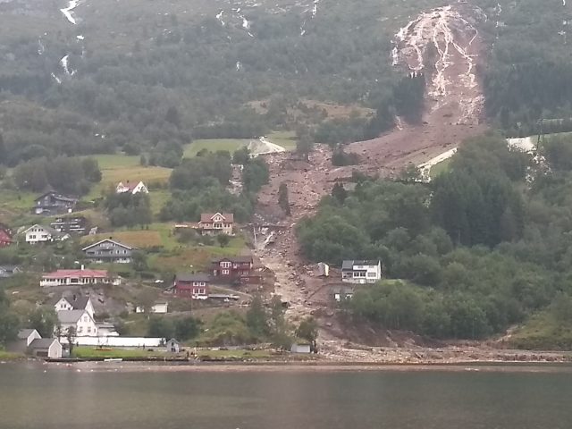
The landslide at Vassenden in Norway on 30th July 2019. Image by Hallstein Dvergsdal, via NK.
.
NRK has a report of another series of the landslides, this time at Halvgjerda. The image below, also from NRK, shows the aftermath of the series of failures:-
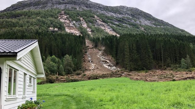
The landslides at Halvgjerda in Sogn og Fjordane on 3oth July 2019. Image via NRK
.
A local lad, Jakob Slåtten, captured one of these in a dramatic video, which can be seen on the NRK page. It’s worth a look.
31 July 2019
The best landslide videos of 2019
A still from a video on Youtube showing a tractor being hit by a boulder. No casualties were reported.
The best landslide videos of 2019
The (Northern Hemisphere) summer of 2019 is proving to be exceptionally active from a landslide perspective, with multiple events worldwide. Indeed, to date I have recorded 96 fatal landslide events in July alone, smashing the previous record of 88. This seems to reflect a large number of intense rainfall events, including an active summer monsoon in both South and East Asia. The upshot is that a number of good landslide videos are emerging. Rather than posting them iteratively, I thought it would be good to set up a post to collate them. I will endeavour to keep this updated as new videos emerge.
Whilst the focus will be on landslides during 2019, I will also post interesting videos from previous events too, where I have not featured them previously. The first on the list is one of these. Please use the comments to highlight any video that should be included.
1. An intriguing video of a valley-blocking landslide from Hunza, Pakistan (in 2018)
Thanks to Matt Moore for highlighting this one. I have never seen a slide quite like this – it is a beautiful illustration of the ways in which slope controls movement rate, and multiple pulses of activity can combine to create a complex deposit:
.
2. The debris flows at the Tour de France
It’s not often the case that landslides stop a major sporting event. The extreme rainfall in the French mountains last week triggered debris flows, which were well-captured by the huge numbers of spectators along the route:-
.
3. Extreme erosion of fill in Canada
Thanks to Peter Weisinger for highlighting this one. The journalist Tareq Hadhad in Canada tweeted a beautiful video of rapid erosion, and bank collapse, of fill in Antigonish, Canada.
We are living an incredible day in the Antigonish area in Nova Scotia after a massive rainy day like never before … And roads are literally collapsing leaving our cars stock behind. It’s just the beginning of the effects of Climate change! terrifying. pic.twitter.com/i4unhDzuin
— Tareq Hadhad (@TareqHadhad) July 29, 2019
Frustratingly, but oh so predictably, the tweet drew the ire of the ridiculous climate change conspiracy community. Sigh!
4. Genuinely terrifying “shooting stones” in northern India
If you ever want a reminder of why you should never risk getting in the way of a rockfall, this is it:
.
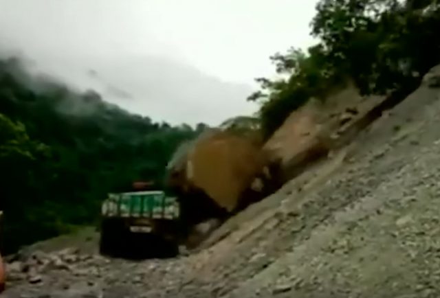
5. Boulder vs tractor in Sikkim
It wasn’t a fair fight. Fortunately no-one was hurt, but this was probably economically ruinous for the owner of the vehicle:-
.
6. A landslide near Champawat in India
This landslide reportedly occurred on 31st July in Champawat in Uttarakhand, India. The slide is almost majestic in progress:-
.
7. Six amazing landslide videos from Bhutan
This is a remarkable collection of landslide videos from Bhutan. The fifth one is particularly interesting:-
.
8. Cut slope failures in residual soil in Solan, India
Unfortunately, it is hard to argue that this is anything other than poor design:-
.
9. A very near miss for a group of Kayakers on Lake Superior
This bluff collapse occurred at Pictured Rocks National Lakeshore on Lake Superior on 13th August 2019. It was a near miss for the kayakers. Remarkably, this collapse was captured from a drone and from the boats:
.
There is also a decent video that captures the drone footage in more detail:-
Note the flyrock!
 Dave Petley is the Vice-Chancellor of the University of Hull in the United Kingdom. His blog provides commentary and analysis of landslide events occurring worldwide, including the landslides themselves, latest research, and conferences and meetings.
Recent Comments