
4 March 2020
Baixada Santista: significant landslides in Brazil this week
Baixada Santista: significant landslides in Brazil this week
Heavy rainfall on 2 and 3 March 2020 has triggered many landslides in the urban area of Baixada Santista in SE Brazil. Globo has a good report that provides details of the losses – it was detailing 18 fatalities at the time of publication, with a further 30 people reported missing. Rainfall totals in Guaruja are reported to have been in the region of 300 mm, with many other areas receiving over 100 mm. The same article has two maps showing the distribution of the recorded landslides and the losses to date:-

Maps showing the distribution of landslides in Baixada Santista. Maps published by Globo.
.
In one case, in Morro do Macaco Molhado (shown on the map above) a landslide buried a 25 year old woman and her son aged 10 months. Both were killed. Sadly, two members of the fire and rescue service were killed in a second landslide at the same location whilst trying to save the victims.
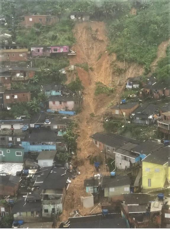
There are some images online showing the nature of the landslides in Baixada Santista. For example, this is a landslide in Guaraja:-
A landslide in Guaraja in Baixada Santista, published by Globo and collected by Carlos Nogueira/A Tribuna.
.
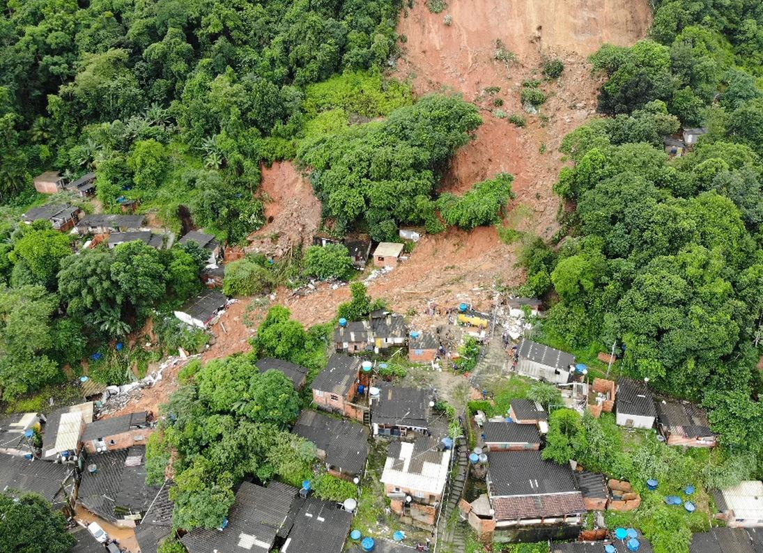
Meanwhile, Globo has published this image of a landslide at Morro do Guaraja, which has started as a shallow slip on the hillside (note the precarious houses built on platforms on the slope), and has then channelised through the urban area, probably following a roadway:-
A landslide in Morro de Guaraja in Baixada Santista, published by Globo.
.
Heavy rainfall in the south of Brazil frequently occurs in the early months of the year, triggering significant numbers of landslides. In January 2011 for example heavy rainfall in Rio de Janeiro killed 903 people, including 424 people in Nova Friburgo and 378 people in Teresópolis. The majority of the fatalities were the result of landslides and the resultant channelised debris flows.
28 February 2020
More information about the Salkantay landslide and mudflow
More information about the Salkantay landslide and mudflow
Over the last 24 hours more information has become available about the Salkantay landslide and mudflow. Oscar Vilca has kindly contacted me to say that the event occurred on 23 February 2020, and not 24 February as had been widely reported. I will correct my original post.
The triggering event is being described as an ice / rock avalanche with an initial volume of 400,000 cubic metres. This has clearly bulked up to form a mudflow with a much higher volume, presumably through entrainment of ice and saturated debris in the channel. This is similar to the Seti River rock avalanche and debris in Nepal in 2014, which also had devastating effects. On this occasion the initial collapse may have been smaller, but the mudflow was on a similar scale.
On Twitter, Julio Montenegro G. has posted an interpretation of the event, based upon an image of the scar, which has then been located on pre-event imagery:-
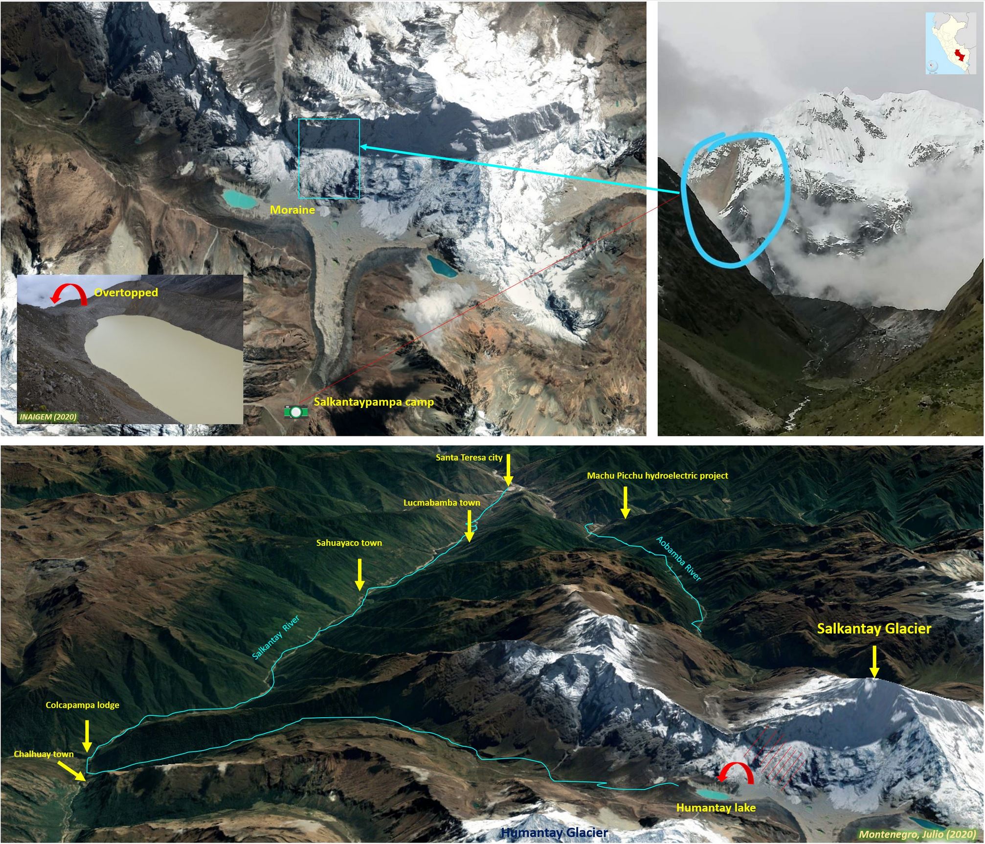
An interpretation of the Salkantay landslide and mudflow posted to Twitter by Julio Montenegro
.
I am not sure as to the origin of the image that shows the scar of the initial failure, but a better version was posted to Twitter by Turismo Peru:-
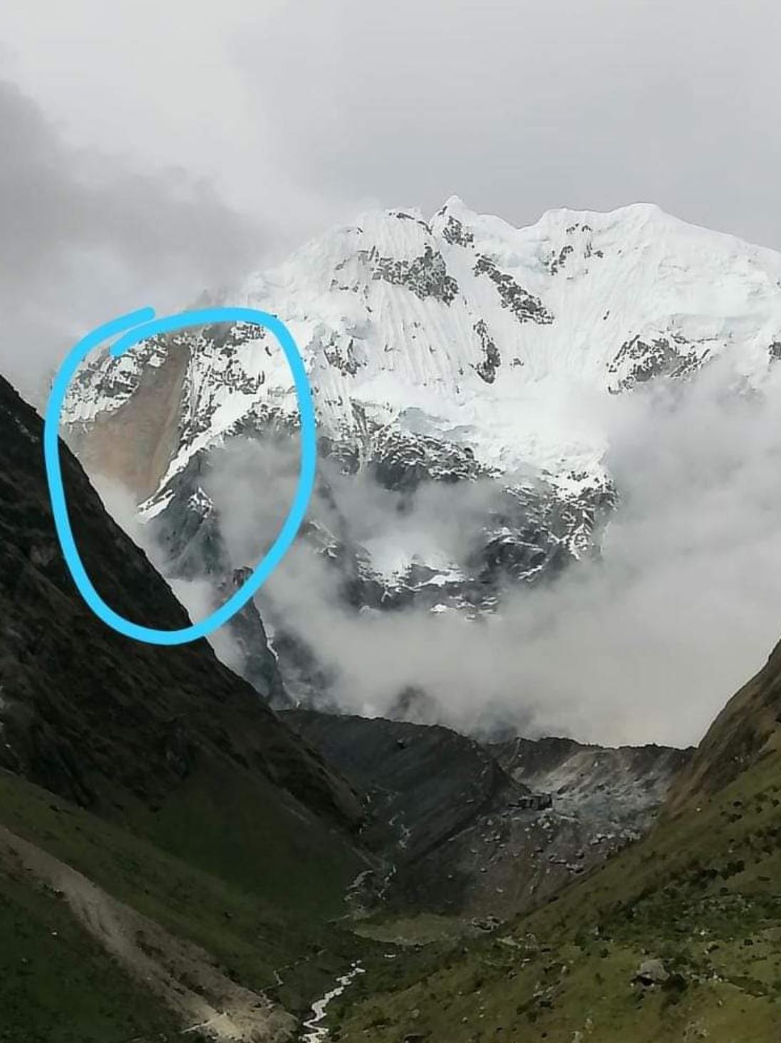
The scar of the Salkantay landslide, posted to Twitter by Turismo Peru.
.
If this is indeed the scar then my interpretation is that this is a classic wedge failure in the rock mass, with a near vertical fall onto the ice and moraine at the toe of the slope. The rock slope would have been a mixture of rock and ice, both on the surface and within fractures. On impact the mass has probably fragmented to form an ice / rock avalanche, which has then entrained debris and ice / snow / water, transitioning to become the mudflow seen in the videos. This has behaved in a manner that is akin to a lahar, with a large volume, high velocity and long runout.
Reports suggest that Salkantay Cocha lake remains intact, but that waves within the lake, generated by the landslide, have caused some erosion of the moraine dam. This now needs to be monitored.
There are of course some real human tragedies in this disaster. The estimated human cost appears to be 13 people.
27 February 2020
Breaking News: a catastrophic glacier collapse and mudflow in Salkantay, Peru
Breaking News: a catastrophic glacier collapse and mudflow in Salkantay, Peru
On 23 February 2020 (corrected – this was erroneously reported as 24 February 2020) an enormous, catastrophic debris flow tore down the Salkantay River in Santa Teresa, Peru. This event has killed at least four people, with a further 13 reported to be missing. Given the magnitude of the flow, this number is probably uncertain.
The mudflow was captured in an extraordinary video posted to Youtube:-
.
A mudflow on this scale usually requires an extraordinary cause. Diario Correo in Peru has an explanation – this event was caused by glacial collapse on Salkantay mountain. This hypothesis is proposed by Oscar Vilca Gómez, who the article describes as a specialist in Hydrology and Glaciology. He visited the site site of the detachment as part of a research team from the National Institute for Glacier Research of the Ministry of Environment. They propose that an ice / rock avalanche detached from the mountain, crossed the Salkantay Cocha lake, and generated the huge debris flow.
The article includes the following image of the site:-
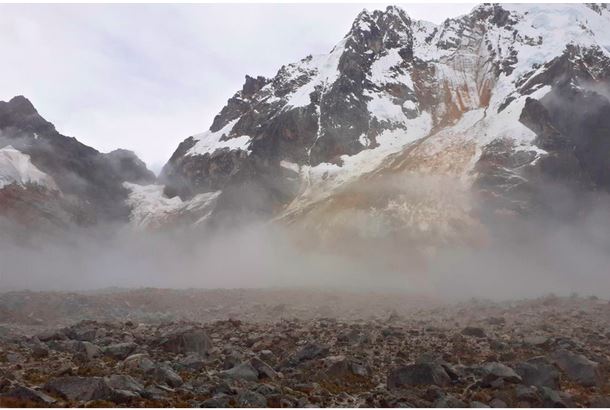
The site of the rock / ice avalanche at Salkantay in Peru. Image by Benito Moncado via Diario Correo Peru.
.
In first inspection this appears to be a wedge failure in the rock mass that has fragmented to generate the rock / ice avalanche. The photographer appears to be standing on the landslide deposit.
Salkantay (which also appears to be named Salcantay at times) is located at -13.340, -72.540. Salkantay Cocha lake appears to be at -13.342, -72.569. At the moment it is not clear as to which slope has failed to generate this ice-rock avalanche and debris flow. There is excellent Google Earth imagery of this area, so it should be possible to get a better understanding in due course.
At the moment details of this very significant event are somewhat unclear; I hope that more details will emerge. This event is reminiscent of the 2012 Gayari ice and rock avalanche in Pakistan and the 2017 Villa Santa Lucia landslide in Chile.
26 February 2020
The 1954 Prospect Point Rockfall at Niagara Falls
The 1954 Prospect Point Rockfall at Niagara Falls
Regular reader George Haeh has very kindly pointed out a remarkable video on Youtube showing the 1954 Prospect Point Rockfall at Niagara Falls:-
.
This is an archive British Movietone newsreel, complete with dramatic music and rather elegant commentary. The associated text suggests that the rockfall had a mass of about 168,000 tonnes (185,000 tons). Niagara Frontier has this image of the rockfall:-
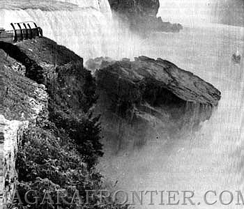
The 1954 Niagara Falls rockfall. Image via Niagara Frontier.
.
There is a good article about the Niagara Falls rockfall on the Niagara Frontier website. The rockfall occurred on 28 July 1954 on the American Falls side of the site. It appears that cracks at the site, shown in the video above, were first noticed by a nine-year old child the day before the failure. The rockfall left a large debris pile, which then became a tourist attraction in its own right. In the aftermath, the Niagara Frontier State Parks Commission undertook blasting to remove rock left in a precarious position, with large blasts on 6, 12 and 16 August 1954. Thereafter the site was deemed to be safe.
25 February 2020
Spatial and temporal patterns of landslide losses in Colombia
Spatial and temporal patterns of landslide losses in Colombia
Back in 2012 I posted about the levels of landslide losses in Colombia, which is one of the most landslide prone countries, based on my fatal landslide database. I noted that levels of loss are high, especially in the western side of the country, and that Colombia needs to be a priority country if we are to reduce loss worldwide. It is good that the 13th International Symposium of Landslides will be held there later this year (COVID 19 permitting I guess), which will draw attention to the challenges in that country.
In that context, it is really good to see a new paper (Aristizábal and Sánchez 2019), published in the journal Disasters, which seeks to analyse losses from landslides in Colombia between 1900 and 2018. This is a truly epic piece of work – the authors have used multiple datasets at national and regional levels to record 30,730 landslides over the 118 year period of the study. As such this is one of the most detailed and comprehensive national landslide studies published to date.
There is much to take away from this study, but I’ll highlight some of the more interesting findings. First, not unexpectedly, the authors found that landslides are concentrated in the mountainous west of Colombia, as the map below shows:-
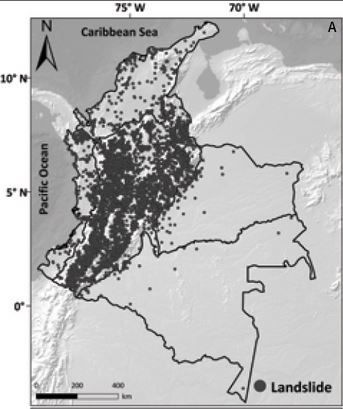
The distribution of landslides in Colombia recorded by Aristizábal and Sánchez (2019).
.
Of these landslides, 2,328 caused at least one fatality, with a total of 34,198 deaths. This is much higher than had been previously recorded. As always for these types of very long-term studies, the majority of landslide fatalities have occurred comparatively recently:-

Annual landslide occurrences and fatalities: the five most catastrophic events in Colombia, from Aristizábal and Sánchez (2019)
.
It is really interesting to note that landslides, and the resultant fatalities appear, to have peaked in about 2011 after showing a notable increase with time, and have declined substantially since then. So, for example, the number of recorded landslides was 3,545 in 2011 but just 123 for 2016. The reasons for this are not entirely clear; Aristizábal and Sánchez (2019) suggest that:
“This might be due to advances in risk reduction in Colombia, especially making legally mandatory implementation of the land use planning programme (Planes de Ordenamiento Territorial), but it is too soon to say for sure. Much more analysis needs to be conducted and more evidence acquired to prove and compare the effectiveness of such risk reduction policies.”
If this is the case then it would be one of the most impressive landslide hazard management programmes undertaken at a national level to date. However, I also note that 123 landslides in a year in a country such as Colombia seems low to me, so I wonder if this might in part be an artifact of the data.
This is an excellent and very welcome study, which provides insight into the levels of loss in Colombia. It would be good to see more studies of this type for other landslide-prone countries.
Reference
Aristizábal, E. and Sánchez, O. 2019. Spatial and temporal patterns and the socioeconomic impacts of landslides in the tropical and mountainous Colombian Andes. Disasters. DOI: 10.1111/disa.12391
24 February 2020
The giant Kandersteg rock avalanche in the Bernese Alps in Switzerland
The giant Kandersteg rock avalanche in the Bernese Alps in Switzerland
The Kandersteg rock avalanche is a giant landslide located in the Bernese Alps in Switzerland. The location of the scar of this slide is 46.477, 7.715, and is very visible on Google Earth:-
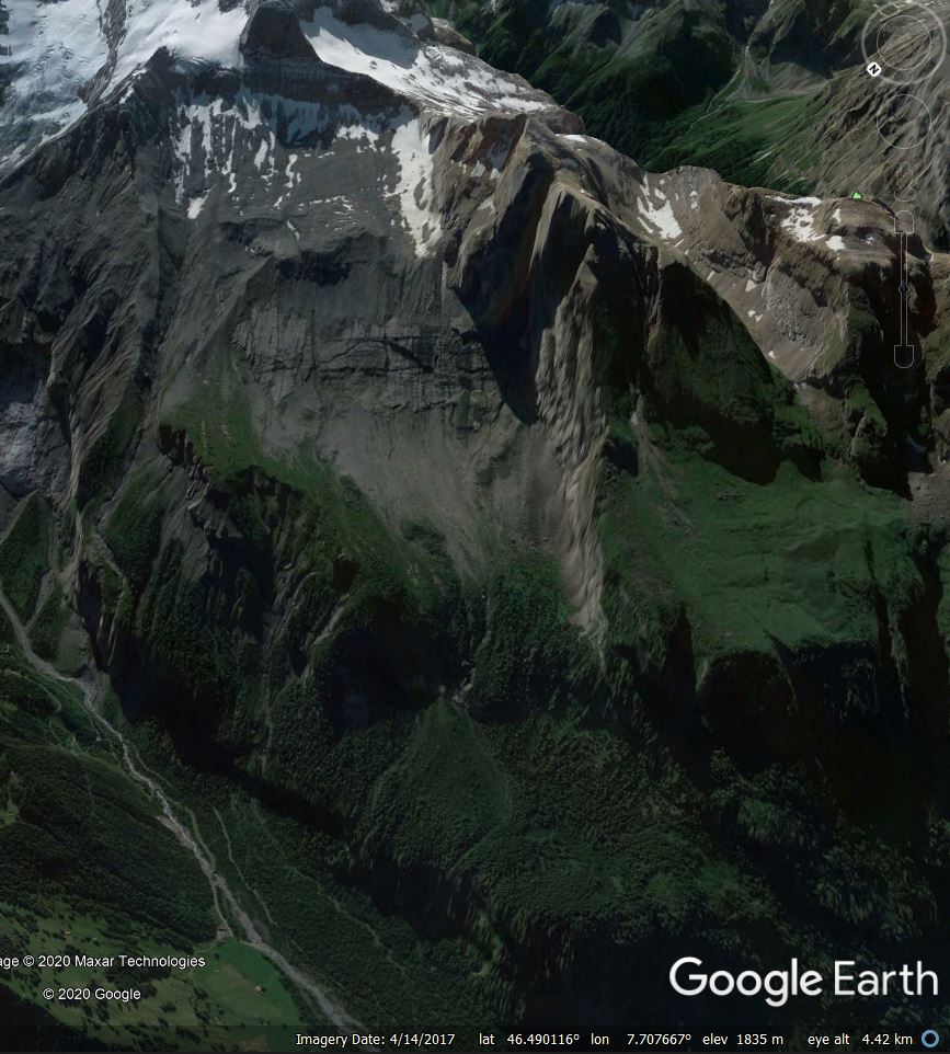
Google Earth image showing the scar of the Kandersteg rock avalanche in Switzerland
.
In a paper just published in the journal Landslides, Singeisen et al. (2020) provide a very comprehensive analysis of the landslide, including the deployment of a new set of dating methods to try to ascertain the timing of the failure. The description of the landslide is impressive – it started as a planar rockslide high on the mountain side. The authors estimate that 750 to 900 million cubic metres of limestones sandstones detached along pre-existing discontinuities from the northwest face of the Fisistock peak. As the image above shows, the landslide descended a very steep slope into the valley below – the schematic diagram below, from Singeisen et al. (2020), provides some details of the geometry of this part of the landslide:-
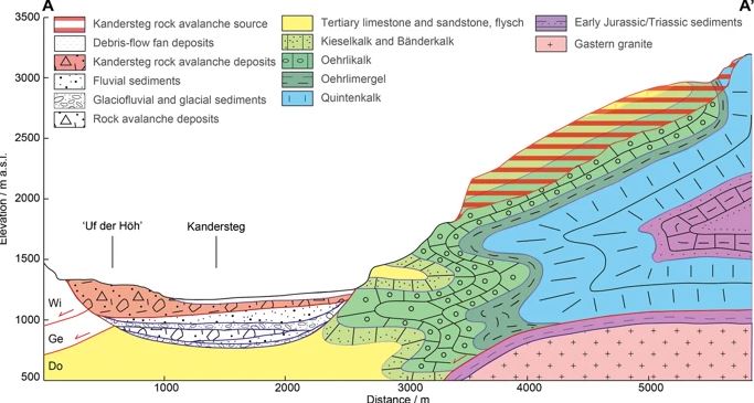
Schematic diagram of the detachment zone of the Kandersteg rock avalanche. Diagram from Singeisen et al. (2020).
.
The large descent into the valley caused the rock mass to fragment, forming a rock avalanche that traveled northwards along the valley, during which time it entrained sediments from the valley floor. By the time the landslide stopped moving it had increased in volume to about 1,100 million cubic metres – i.e. 1.1 cubic kilometres. The landslide traveled a total distance of about 10 km, as the map from the paper below shows. The source zone of the landslide is the red area highlighted in the southeast corner of the map, whilst the landslide deposit is outlined in purple:-
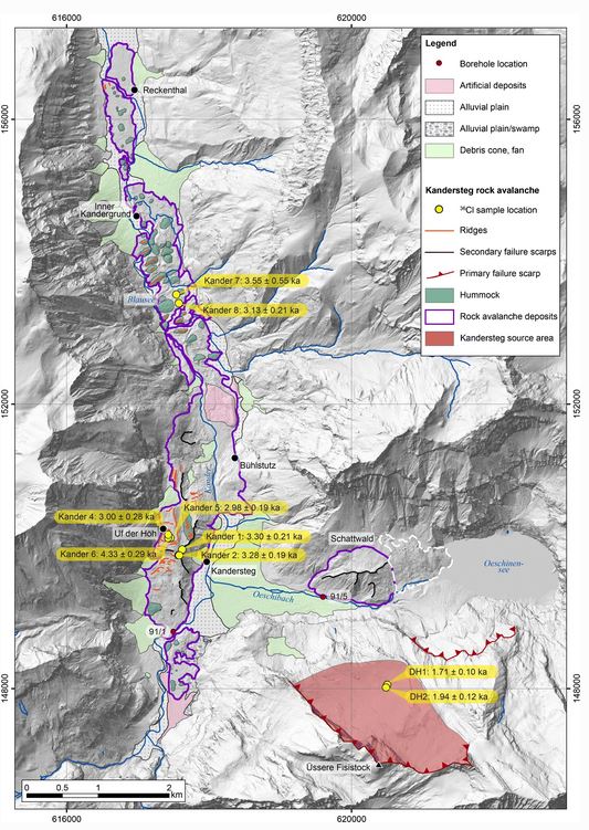
Map showing the source area and deposit of the Kandersteg rock avalanche in Switzerland. Diagram from Singeisen et al. (2020).
.
The map above provides some of the dates from the research. Singeisen et al. (2020) suggest that this failure occurred about 3,200 years before the present. Of course it is hard to know what might have triggered this landslide, but the authors note that there is a cluster of large Alpine landslides with dates from about this time. There is some evidence that this was period in which glaciers advanced and conditions were wetter. However, giant landslide may collapse through progressive failure rather than triggering, so such interpretations are inevitably uncertain.
Reference
Singeisen, C., Ivy-Ochs, S., Wolter, A. et al. 2020. The Kandersteg rock avalanche (Switzerland): integrated analysis of a late Holocene catastrophic event. Landslides. https://doi.org/10.1007/s10346-020-01365-y
20 February 2020
Hardin County: a dramatic landslide in Tennessee
Hardin County: a dramatic landslide in Tennessee
On Saturday 15 February 2020 a dramatic landslide occurred in the Chalk Bluff area of Hardin County in Tennessee, USA. The landslide, which is located at 35.385, -88.284, destroyed rather beautiful two houses located at the top of a bluff. Fortunately no-one was harmed, although the houses are a total loss.
Fox 17 News has posted some imagery and a video of the landslide, including this image of the early part of the failure:-
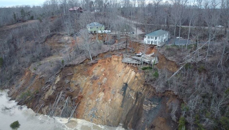
The early phases of the landslide at Hardin County in Tennessee. Image via Fox 17 News.
.
Whilst this image shows a later phase, when the slide had retrogressed significantly, causing the loss of the two properties:-
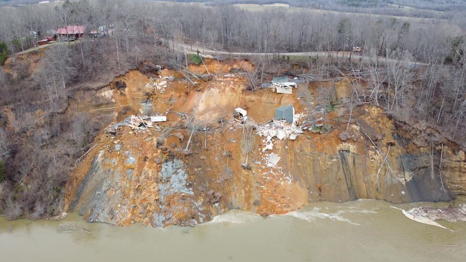
The later phases of the landslide at Hardin County in Tennessee. Image via Fox 17 News.
.
On Youtube, Knox County News have posted a video of the collapse of one of the two properties:-
.
Whist News4 WSMV Nashville has posted drone footage of the aftermath of the landslide:-
.
Google Earth imagery from November 2012 shows the site quite clearly, as the trees had no leaves:-
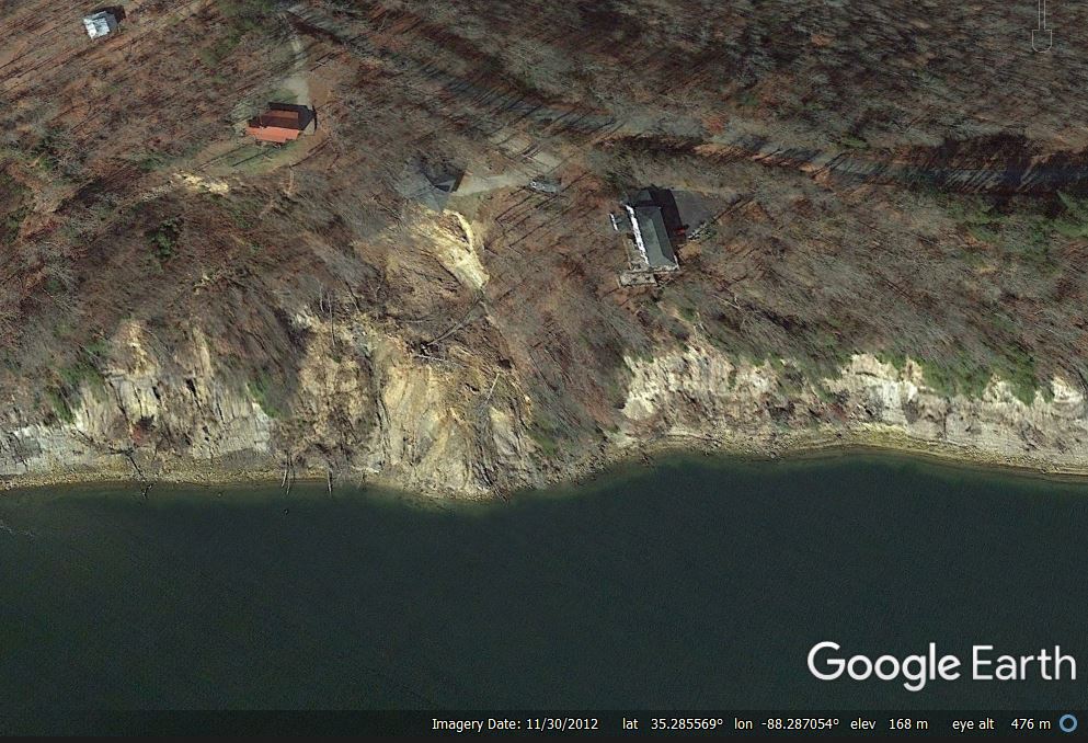
Google Earth imagery from November 2012 showing the site of the landslide at Hardin County in Tennessee.
.
This image appears to show that a smaller landslide has been active for some years, and that it had encroached close to one of the two houses that were lost. The collapse on 15 February appears to be a significant increase in the size of this landslide, driven by a prolonged period of heavy rainfall. As the site is located on the outside of a gentle bend in the river, enhanced erosion would be expected.
The Jackson Sun has some more detail about the landslide. One of the houses, which were built in the 1990s, has been unoccupied, but the other was in daily use. The occupiers were able to recover only a small amount of their possessions before the house was destroyed.
18 February 2020
Further information about the Tylorstown landslide
Further information about the Tylorstown landslide
Yesterday more information emerged about the Tylorstown landslide in South Wales on Sunday 16 February, which was caught on video. Many thanks to the various comments and observations that I’ve received.
The most useful information comes in the form of a pair of oblique aerial images that were tweeted by the National Police Air Service South West Region, who overflew the landslide. This is one of the two images:-
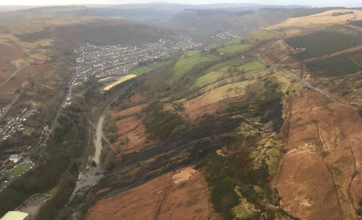
Oblique aerial photograph of the Tylorstown landslide in South Wales. Image tweeted by NPAS SW.
.
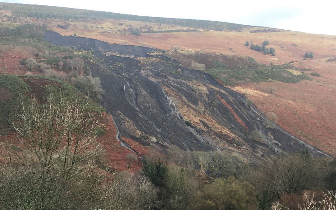
This image shows that the failure originated in the upper of the two spoil heaps. There can be little doubt that this is coal waste. The failure appears to have started as a rotational slip in the spoil, and a part of the rotated, back-tilted block is clearly visible. The lower part of the block has fragmented to form the flows that have reached and inundated the river.
These flows can be seen in more detail in the image below:-
Oblique aerial photograph of the Tylorstown landslide in South Wales. Image tweeted by NPAS SW.
.
This second image shows that the displaced block has failed to generate the flows, and the amount of material in the watercourse. Interestingly, it also hints that there may be a further failure developing to the right of the slipped mass, although better imagery is needed to be clear.
Rotational failure that transitions into a flow is the classic failure mode for coal waste in South Wales – indeed the official tribunal found that this was the mechanism for the Aberfan landslide. This was the description of the landslide:-
“On 21st October 1966 there were a number of slipping movements of a rotational kind accompanied by settlements of the crest of the tip. These movements gave rise about 9-10 a.m. to a flow slide, the relatively dry material in the flow slide pouring down the mountainside and into the village. it was this flow slide which engulfed the school and houses in Moy Road.”
The waste pile is not shown on the 25 inch OS map that was published in 1919, but it is depicted on the 1956 map. Interestingly the early maps show a stream flowing through the site. It is not clear as to what happened to this stream when the waste was dumped.
17 February 2020
Did South Wales suffer a coal waste landslide yesterday?
Did South Wales suffer a coal waste landslide yesterday?
Yesterday morning the UK Met Office issued a rare red rainfall warning for South Wales, as a result of Storm Dennis. This was a prescient act as the rainfall duly triggered extensive flooding and a number of significant landslides. South Wales is a landslide prone environment – the Welsh Valleys have many natural landslides and, of course, many more that are a legacy of the mining coal mining that so dominated this area for many decades.
One particular landslide is of interest, and may be of real consequence. This occurred close to the village of Tylorstown, at approximately 51.656, -3.434. A part of the event was captured on a video that was posted to the front page of the BBC News website. There is a version of it on Youtube, though I suspect that this is not the original:-
.
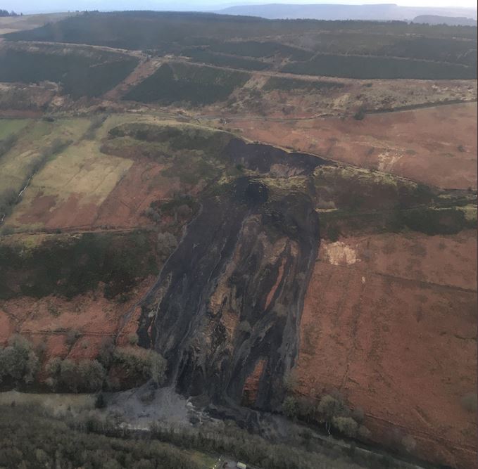
On Twitter, Owen Griffiths posted a very helpful panoramic image of the site of the landslide at Tylorstown:-
Panoramic view of the landslide at Tylorstown in South Wales on 16 February 2020. Photograph posted to Twitter by Owen Griffiths.
.
Based upon that image, I interpret the landslide as occurring on the slope shown in the Google Earth image below:-
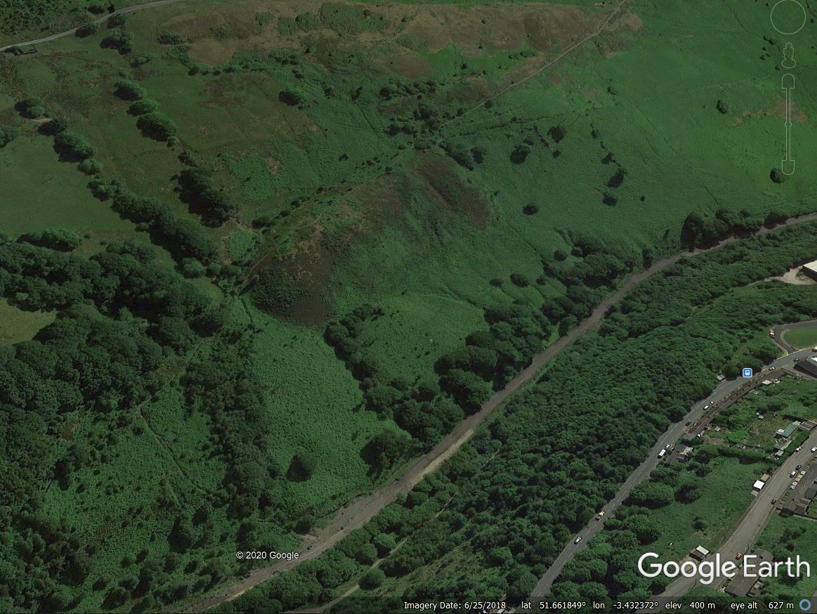
A Google Earth image of the possible location of the Tylorstown landslide in South Wales on 16 February 2020.
.
The origin of the landslide appears to be a spoil heap on the valley wall. The historic 1920-1940 Ordnance Survey map shows the route of the spoil conveyors from the Tylorstown Colliery (also shown on the map as Pendryrys Colliery) to this location, whilst the 1955-61 map shows spoil at this site:-
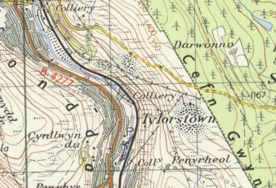
The 1955-61 OS One Inch 7th series map of the location of the Tylorstown landslide, showing spoil at the source of the failure.
.
The photograph of the site suggests that the failure captured on video was only a small part of a larger failure. We need better images, but on first inspection is appears that a large mass has slipped, leaving the large scar that can be partially seen at the rear of the failure, and that a small part of this slipped and disrupted mass has then turned into the more mobile flow captured on video.
Much more detail is needed on this failure than is available at the moment, but since the clean up after the Aberfan landslide coal spoil tip failures have been rare in Wales. If (and this is an unknown at this point) this is a coal waste landslide then we need to know why it has occurred. Is it possible that the new, extreme rainfalls that we are now seeing as a result of global heating are rather greater than had been anticipated when the reprofiling was undertaken?
That is a pressing question that can only be addressed by examining this failure properly.
14 February 2020
Elkhorn City, Kentucky: a fiery train derailment by a landslide
Elkhorn City, Kentucky: a fiery train derailment by a landslide
On 13 February 2020 at about 7 am a freight train was derailed by a landslide close to Elkhorn City in Pike County in Kentucky, USA. Fortunately the train crew were able to escape the accident even though five carriages were derailed. The train consisted of three locomotives, 96 freight cars carrying ethanol, and two sand cars. Some of the carriages caught fire after the accident, meaning that the train crew had to be rescued by boat.
This image, tweeted by the Kentucky Energy & Environment Cabinet, shows the extremely messy aftermath of the accident:-
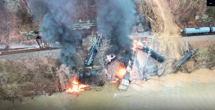
The aftermath of the rail accident outside Elkhorn City in Kentucky, caused by a shallow landslide on 13 February 2020. Image tweeted by Kentucky EEC.
.
The landslide can be seen on the right hand side of the image, with debris that extends to the river. The lead locomotive is centre right, with the cab close to the river. Videos suggest that the train crew had to be rescued by boat from this location. Note the various derailed freight cars.
I have struggled to find a good image of the landslide itself, but a video posted by WYMT includes the following still:-
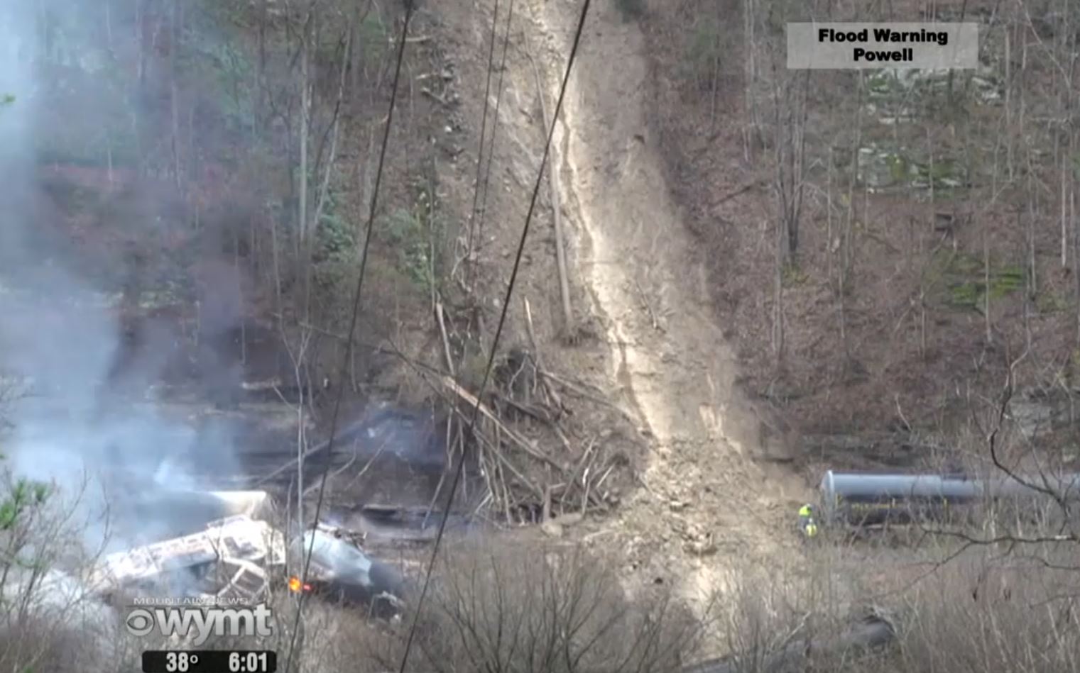
The aftermath of the landslide at Elkhorn City in Kentucky that derailed a train on 13 February 2020. Image from a video posted by WYMT.
.
From this image the landslide appears to be a planar slide on a steep, wooded slope. Based on the news reports, my preliminary interpretation is that the landslide occurred on the slope shown below, which is at 37.333, -82.371:-
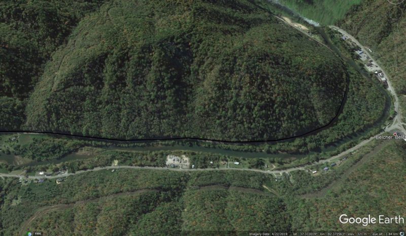
Google Earth image showing the possible location of rail accident outside Elkhorn City in Kentucky, caused by a shallow landslide on 13 February 2020.
.
The landslide was undoubtedly caused by the prolonged heavy rainfall currently affecting large parts of the United States. Landslides have been reported elsewhere too, such as in West Virginia.
Landslides induced rail derailments are not unusual, fortunately in this case there has been no loss of life.
 Dave Petley is the Vice-Chancellor of the University of Hull in the United Kingdom. His blog provides commentary and analysis of landslide events occurring worldwide, including the landslides themselves, latest research, and conferences and meetings.
Recent Comments