
24 February 2020
The giant Kandersteg rock avalanche in the Bernese Alps in Switzerland
Posted by Dave Petley
The giant Kandersteg rock avalanche in the Bernese Alps in Switzerland
The Kandersteg rock avalanche is a giant landslide located in the Bernese Alps in Switzerland. The location of the scar of this slide is 46.477, 7.715, and is very visible on Google Earth:-
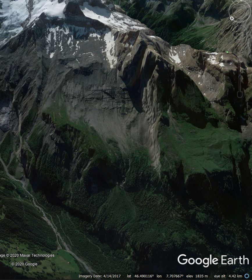
Google Earth image showing the scar of the Kandersteg rock avalanche in Switzerland
.
In a paper just published in the journal Landslides, Singeisen et al. (2020) provide a very comprehensive analysis of the landslide, including the deployment of a new set of dating methods to try to ascertain the timing of the failure. The description of the landslide is impressive – it started as a planar rockslide high on the mountain side. The authors estimate that 750 to 900 million cubic metres of limestones sandstones detached along pre-existing discontinuities from the northwest face of the Fisistock peak. As the image above shows, the landslide descended a very steep slope into the valley below – the schematic diagram below, from Singeisen et al. (2020), provides some details of the geometry of this part of the landslide:-
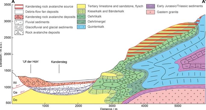
Schematic diagram of the detachment zone of the Kandersteg rock avalanche. Diagram from Singeisen et al. (2020).
.
The large descent into the valley caused the rock mass to fragment, forming a rock avalanche that traveled northwards along the valley, during which time it entrained sediments from the valley floor. By the time the landslide stopped moving it had increased in volume to about 1,100 million cubic metres – i.e. 1.1 cubic kilometres. The landslide traveled a total distance of about 10 km, as the map from the paper below shows. The source zone of the landslide is the red area highlighted in the southeast corner of the map, whilst the landslide deposit is outlined in purple:-
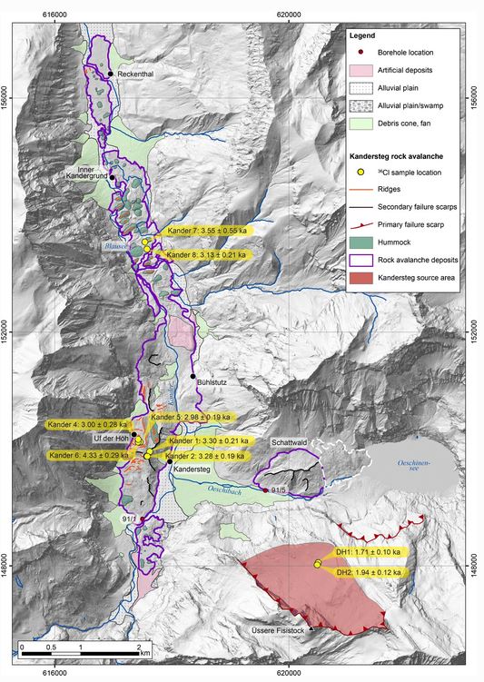
Map showing the source area and deposit of the Kandersteg rock avalanche in Switzerland. Diagram from Singeisen et al. (2020).
.
The map above provides some of the dates from the research. Singeisen et al. (2020) suggest that this failure occurred about 3,200 years before the present. Of course it is hard to know what might have triggered this landslide, but the authors note that there is a cluster of large Alpine landslides with dates from about this time. There is some evidence that this was period in which glaciers advanced and conditions were wetter. However, giant landslide may collapse through progressive failure rather than triggering, so such interpretations are inevitably uncertain.
Reference
Singeisen, C., Ivy-Ochs, S., Wolter, A. et al. 2020. The Kandersteg rock avalanche (Switzerland): integrated analysis of a late Holocene catastrophic event. Landslides. https://doi.org/10.1007/s10346-020-01365-y
 Dave Petley is the Vice-Chancellor of the University of Hull in the United Kingdom. His blog provides commentary and analysis of landslide events occurring worldwide, including the landslides themselves, latest research, and conferences and meetings.
Interestingly there is also a Tsunami hazard in Kandersteg, form the Oeschinensee (lake) potentially triggered by a landslide above it.
I translated Heim’s book in 1989…Landslides and Human Lives.
The profile Heim showed is on his Fig 10. It would be interesting to compare this with the latest findings, particularly the reach of the runout…fahrboschung.