
17 June 2011
A toppling failure in a lemon meringue
Dessert at Michele’s house last night was a rather wonderful lemon meringue cooked by her mother, Christine (thanks!). The meringue had already been cut; when we started upon it this was what found:

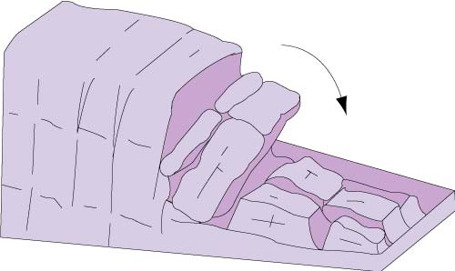
The strawberries give the game away – the outer edge of the meringue had undergone what initially appeared to be a classic toppling failure, with clear evidence of rotation outwards as the collapse developed. At first glance this is about as close to a textbook example as you are ever likely to get, as per this BGS illustration:
An aerial view of the situation provides some clarity regarding the process:

This allows us to start to understand what has gone on here. Note the weaker lemon curd and soft basal meringue below the more cohesive cream topping. After erosion of the toe of the slope (removal of the previous slice), the soft basal meringue has not been able to withstand the combined load of the (dense) cream and the strawberries, and has flowed outwards. This has put the cream under tension (and I think that as with many cohesive materials, its tensile strength is probably low ), allowing a crack to develop. At that point disaster became inevitable.
In the interests of science (as you can see, I am willing to suffer for this blog)! we decided we should test the hypothesis by cutting a cross-section through it:

The toppled block is clearly visible on the right. Note the thinning from left to right of the lower layer of the less brittle meringue, which has allowed the topple to develop. However, close inspection suggests that here is one additional thing of interest here though. The upper (cohesive) cream layer has also moved forward (note the tension crack on the left side just behind the leftmost strawberry), suggesting an additional complexity to the process. Unfortunately, this suddenly means that the mechanism is not a simple topple but is instead a complex mix of translational motion, deep-seated ductile deformation and toppling. A hypothesis would be that the order of events was:
- Erosion of the toe (removal of the previous piece)
- Ductile deformation of the basal layer
- Development of a tension crack
- Sliding of the cream layer on the lemon curd layer, which pushed the frontal block forward
- Toppling of the frontal block
- Continued sliding of the main block
Unfortunately, it could also be that the topple preceded the translational movement, but at the moment there is no way of knowing. Clearly further research is needed. It is however fair to say that after all this science we had developed an appetite, such that future investigations will need a new meringue…
The lessons here are of course that toppling failures are dominated by the combination of the physics of the system and the mechanics of the materials and that, as in most landslides, systems that initially appear to be simple prove to be rather more complex once investigated properly.
Comments welcome!
16 June 2011
Informal landslides and slopes meeting at Durham, 20th July 2011

Here at Durham University I will be hosting an informal slopes and landslides meeting on 20th July. The aim of the event will be to provide a relaxed platform for the sharing of recent and ongoing work on slopes, ranging from research to interesting projects or engineering designs. We hope to be comparatively informal, and to encourage both discussion and the sharing of new ideas, findings and techniques. The centre point of the day will be a research seminar by our Distinguished International Visitor, Professor Tim Davies from Canterbury University in New Zealand.
We will aim to start at 10:30 (coffee) and 11:00 am for the presentations, with a break for lunch and afternoon tea. The event will finish at 4:30 at the latest, though we might then retire to the pub. The meeting is open to both the research and the practitioner from the practitioner communities. There is no charge to attend, but numbers are limited to about 45 people.
Please feel free to pass this on to anyone else who might be interested. Registration is by email to me at: [email protected] with a deadline of the close of play on 11th July. Given that the room has limited spaces, this will need to be on a first come first served basis. If you, a colleague or a student wish to give a presentation then please could you email me the title by the same date. I hope that we will have 15 minutes for presentations and five minutes for questions.
Responding effectively to disasters
 At the start of its term a little over a year ago, the new UK government commissioned a review by Lord Ashdown into the UK’s response to humanitarian disasters, with a strong emphasis on those associated with natural hazards (especially earthquakes, floods and tropical cyclones). A few months ago the review team produced what is a surprisingly sensible and logical document (NB pdf), which addressed many of the concerns that those of us who work in this area have long felt. Yesterday, the UK Government produced its response, which is outlined in detail here (NB pdf), although the top level summary is more digestible.
I am pleased to say that there is much to applaud here – indeed, in my opinion this is a key step forward. I am not going to discuss every aspect of the report, but thought that I’d highlight soe of the most interesting points:
1. There is a commitment to using science to predict and prepare for disasters
 This is a very promising step forward. There has been an immense amount of frustration in the science community that we can see disasters coming, but no-one listens. This operates on multiple temporal timescales, from anticipation of a potential devastating earthquake in Nepal to a recognition that the flood waves travelling down the Indus were likely to cause mass flooding downstream. There is an emphasis on slow onset disasters too (e.g. drought).
Of course the devil will be in the detail – i.e. how will the government join up organisations like the Department for International Development (DfID) and the science and practitioner communities? There is the opportunity to set up for example regional and/or event specific groups of scientists and civil servants to provide this input, perhaps making use of social networking technologies to streamline the process.
2. Resilience is a key theme
The term resilience means different things to different people, but it has been deeply frustrating to watch development programmes proceeding without adequate consideration of the development of communities that are able to cope with and rebound from shocks. Indeed, often aid agency funded development work appears to render communities less rather than more resilient. The increased occurrence of devastating landslides as a result of road building in Nepal is a key example. Thus, the intention of embedding resilience at the core of the work of DfID is very welcome, and the tangible process of developing regional resilience plans is an important step along the way.
3. Innovation is encouraged
For me perhaps the most startling statement in the document is that DfID will “make humanitarian research and innovation a core part of DFID research and evidence work”. This is startling because it is obvious that this should be the case – in other words, did this really not happen before? Anyway, it is pleasing to see a commitment in this direction. There are many innovative approaches and technologies that can greatly assist in the understanding of disasters, and in delivery of an effective response. This will require thinking outside the normal boundaries – I continue to be hugely impressed by the crowd-sourced work that we undertaken to map building damage in the aftermath of the Haiti earthquake, and on a different scale I undertook my own analysis of damage to the dockyard facilities at Port-au-Prince. DfID should aim to create networks that allow such things to occur – it is an extraordinarily efficient and effective way to work.
4. Search and rescue or surgical and scientific capability?
 Hidden away on page 18 of the report is a very interesting section, which says that the UK Government will:
Develop and deploy niche capabilities, focusing on UK added value, and widen the ‘tools’ in our direct response ‘toolbox’ to:
- Retain the capability to deploy search and rescue, but limit this to where we can genuinely add value; and
- Complement this with other key areas of UK excellence such as surgical or scientific capability.
This is very brave but absolutely right. In the aftermath of an earthquake there is often a scramble to deploy Search and Rescue teams into the affected area, and then huge media coverage of their miraculous rescues. There is little doubt that they do save lives, and no-one can or should question the commitment and integrity of these very brave people. However, in the cold light of day one should ask about the most effective deployment of resources when spaces on aircraft and ground support facilities are limited. The reality is that almost all rescues are carried out by local people in the first few hours after a disaster. Key choke points in the development of assistance often lie in the availability of surgical teams; in the provision of water; in the distribution of food and medicines; in the availability of shelter; and suchlike. Often the help that is needed is very specialist – for example, assistance to army teams in reopening roads blocked by landslides so that access to devastated areas can be provided.
So, this statement that there will be a much more nuanced response in which Search and Rescue teams are deployed when there is a real purpose, but that other types of response will be provided when appropriate, is really very welcome indeed. Again, there will be a need to ensure that the capability is in place well before the disaster occurs, it will be interesting to see how this is achieved. Inevitably there will be a need to think carefully about much more effective use of the military in this situation (the armed forces remain best placed to support this sort of operation); to date we have greatly underused their capabilities.
Conclusion
So, overall this seems like a very positive way forward. The key is going to be to translate this into something meaningful and effective, which will have substantial challenges. A great deal of work is going to be needed to prepare for the types of response described in the document. However, DfID do now seem to understand that there is a community of people out there ready and able to provide help, and that technologies and new ways of working now make this possible. There could be some exciting times ahead!
14 June 2011
Two riverbank collapse videos – don’t miss these!
Regular readers will remember that I visited the Lower Murray river in South Australia earlier this year to spend some time looking at actual and potential riverbank collapses. Riverbank collapses are hugely under-researched, and indeed the amount of data and imagery available on collapse events is poor. A few days ago Ron Dorn highlighted these two amazing riverbank collapse videos from the Missouri River to the south of Bismarck in North Dakota, USA. The first takes 30 seconds or so to get going, but do hang on in there. It is worth it:
The second is smaller but still quite dramatic:
These are quite small failure events, but are really quite interesting.
Rockfalls from M=6.3 aftershock in Christchurch, New Zealand
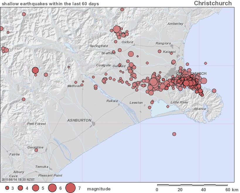
Christchurch was again affected by two large aftershocks yesterday. At 1 pm local time a M=5.6 earthquake occurred, followed at 2:20 pm by a M=6.3 event. Even though these are technically aftershocks from the Darfield event last year, the latter was of course a substantive earhquake in its own right. The map below, from Geonet, shows the distribution of the aftershocks that have occurred in the Christchurch area over the last 60 days:
The map below is a Google Earth image of the aftershocks of the last 24 hours:
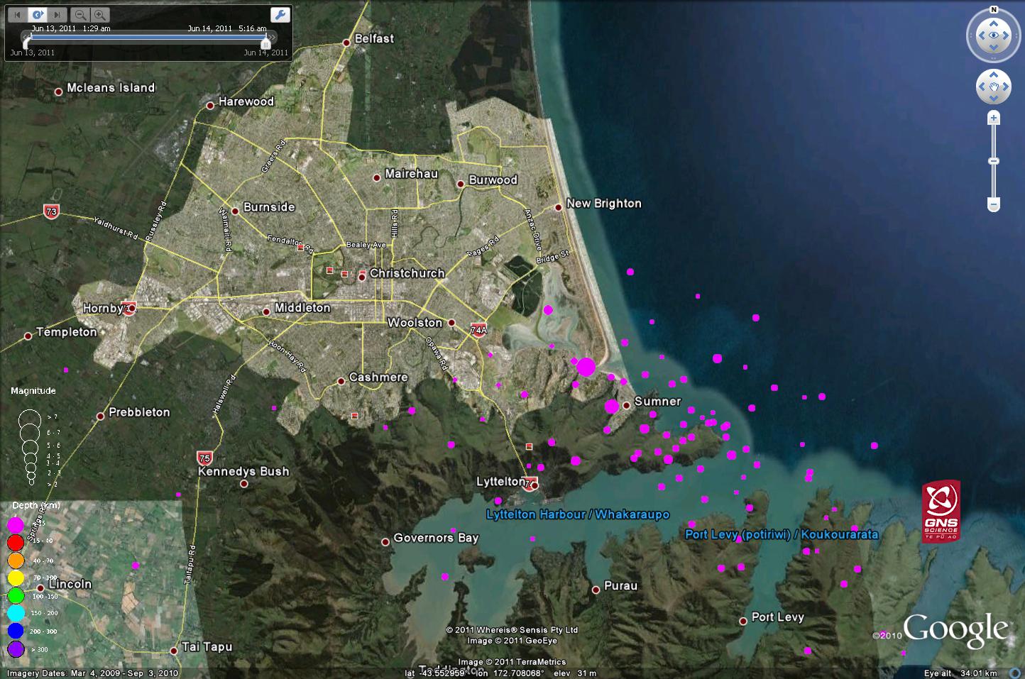
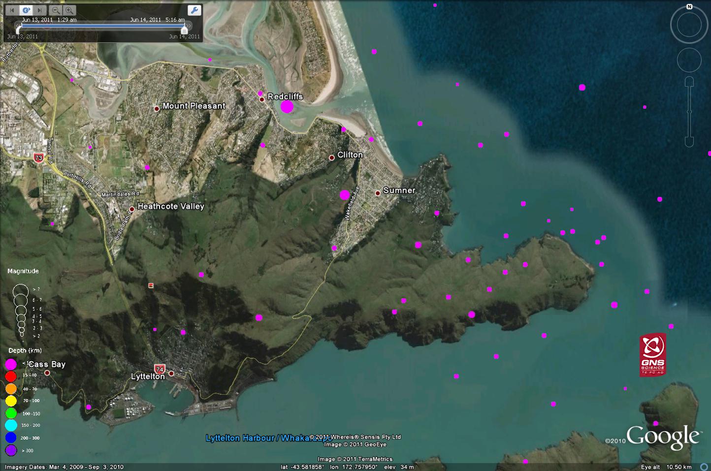
A few interesting things to note here i. First, this cluster of very shallow events is continuing to occur to the east of the main Darfield shock last September, which was well to the west of the city. Second, this cluster us occurring beneath the Sumner peninsular, which is an area that is characterised by steep slopes, as a zoom in of the Google Earth image (still with the aftershocks displayed) demonstrates:
But most remarkable is the exceptionally high ground accelerations that have again been associated with these events. The following is the Geonet map of the peak ground accelerations associated with the larger of the two events:
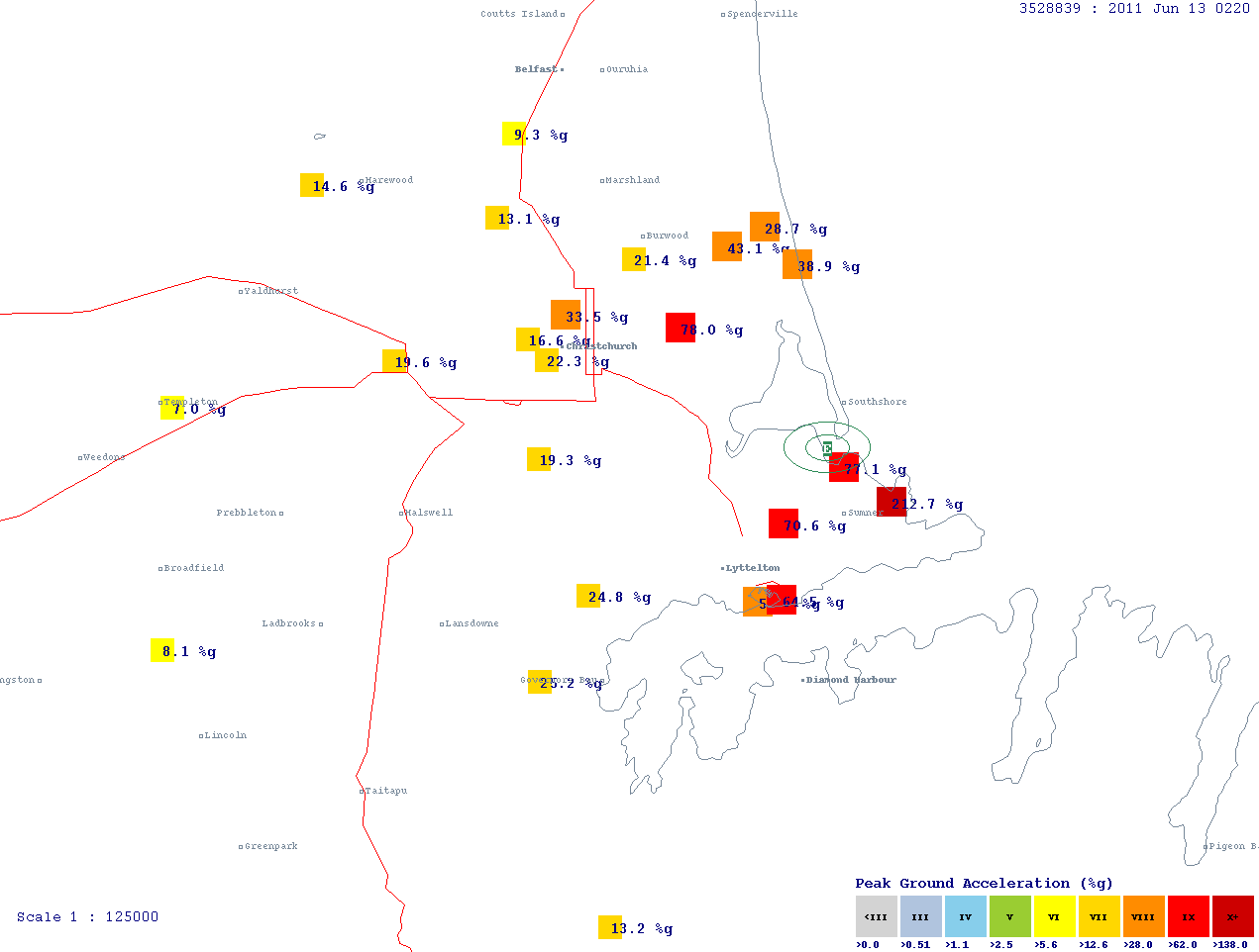
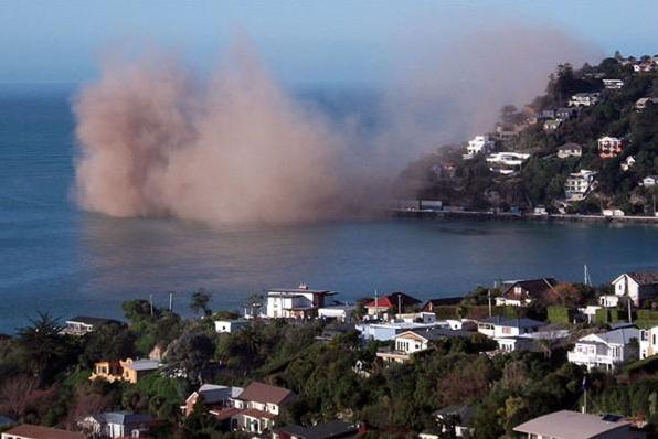
Note that in the Sumner area a peak ground acceleration of over 2 g was recorded!This is really very high indeed for an earthquake of this magnitude. Initial reports suggest that the event may have been associated with movement on another unmapped fault. The same article has some images of the damage associated with rockfalls. The first shows the immediate aftermath of a coastal rockfall event:
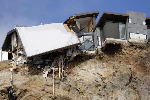
Whilst the second shows the aftermath in terms of the impact on a clifftop home:
There is also quite a nice article about the impacts of the rockfalls on people at the foot of the cliffs here.
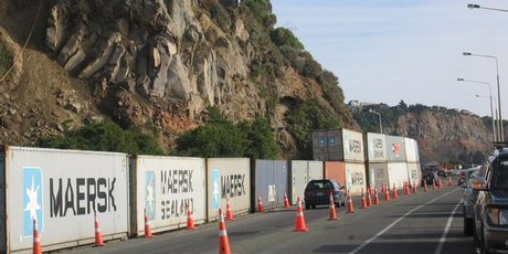
Finally, the magnitude of the problems in the Christchurch area is calling for some novel solution to rockfall problems. NZ Herald has a piece on the use of shipping containers as a temporary but highly effective rockfall protection measure:
http://www.nzherald.co.nz/business/news/article.cfm?c_id=3&objectid=10732093
Comments and/or observations from anyone in the area would be very welcome! I will heading down to New Zealand next month.
11 June 2011
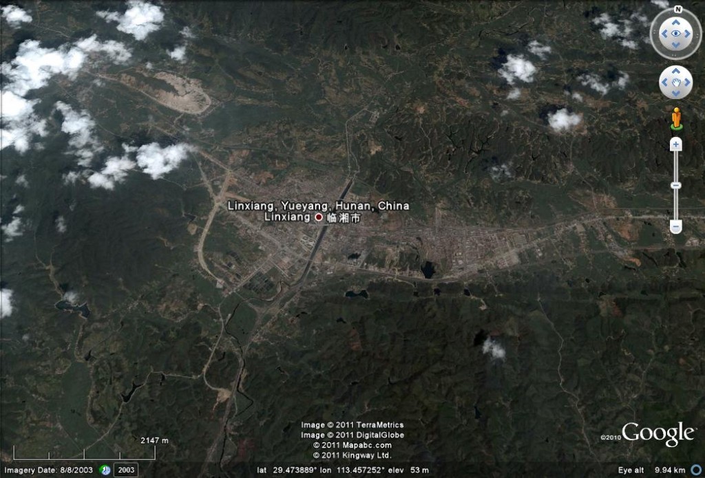
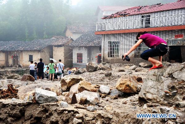
A large landslide in China
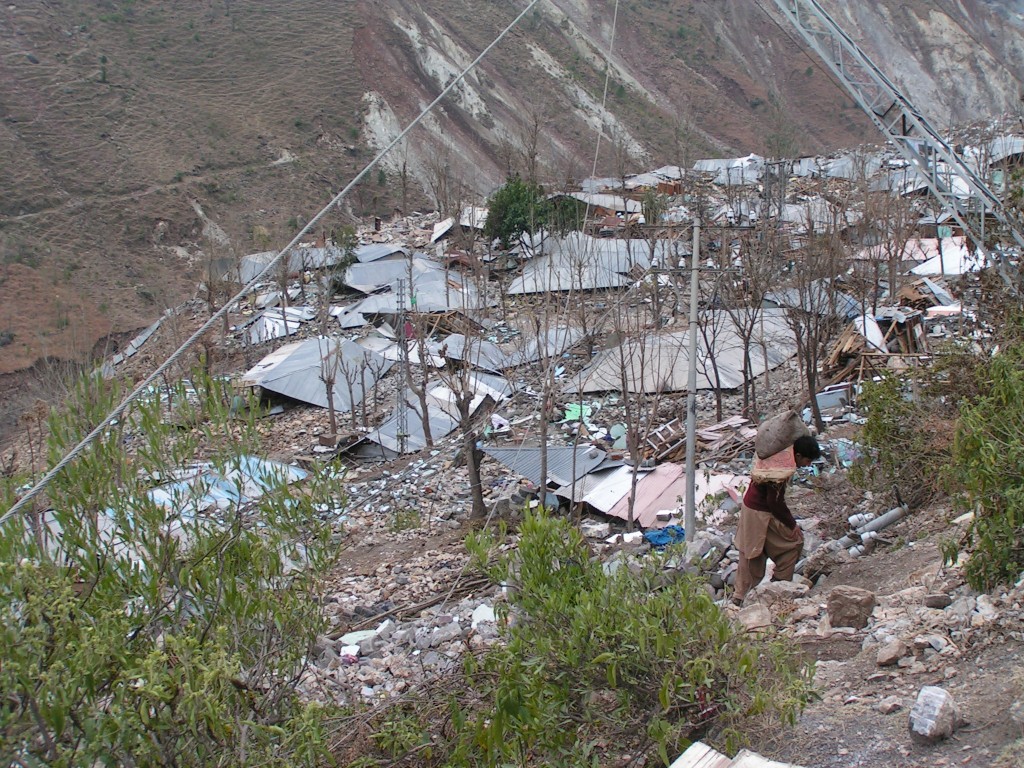
Unfortunately the landslide season in China, which last year caused so much destruction, is once again well underway. So far the largest event appears to have occurred in at Linxiang, which is in Yueyang in Hunan Province:
At this location Xinhua reports that a landslide occurred in the early hours of Friday 10th June. The images suggest that this was probably a debris flow:
http://news.xinhuanet.com/english2010/photo/2011-06/10/c_13922961_4.htm
The news report indicates that 19 people were killed and a further 28 left missing. A further three people were killed by landslides in Xiushui County in Jiangxi Province. To make matters worse, at the time of writing, Tropical Cyclone Farika is making landfall on the coast of Southeast China, and is expected to bring heavy rainfall to Guangdong and Fujian Provinces. This image from Tropical Storm Risk shows the storm track:
![]()
9 June 2011
Landslide reports – June 2011
As an experiment, I am starting what is in effect an open thread. The aim is to invite readers to submit via the comments reports of landslides that occur in June. If successful I will start a new thread each month.
So, please submit any reports that you come cross of landslides that occur this month. This can be in the form of a sentence, a link to a news report, or suchlike. If possible, it would be helpful to include:
- when it occurred;
- where it happened;
- what was the trigger (it is fine to say unknown or even none);
- what was the impact (if any).
However, do still post even if some of this information is missing. Feel free to include any mass movement (including debris flows and rockfalls). If you have photos then feel free to email them to me, and if appropriate I’ll post them below.
My hope is that this will build up a permanent monthly record of landslides around the world.
I’ll go first:
There is a news report of a landslide in the Banihal area of Ramban, Doda District in India today. This killed one personand trapped 26 more in a tunnel, though they have now been rescued. The trigger was intense rainfall.
Report: http://www.indianexpress.com/news/1-killed-26-rescued-after-flash-floods-hit-banihal-area/801478/
Some notable landslides in the last week
As I noted in my previous post, we are now just entering the global landslide season. In the last week there has been a marked increase in significant landslides in the Northern Hemisphere. Clearly, during the summer I won’t be highlighting the vast majority of those that occur, but thought it would be interesting just to draw attention to just a few of those that have happened in the last week:
1. Heavy rains in Haiti
The potentially strong hurricane season in 2011 is a real concern for the earthquake affected areas in Haiti. With vast numbers of people still living in temporary camps, the all the ingredients in the recipe are in place for a major disaster; it is depressing that progress is so slow. Heavy rains at the start of the week served to highlight the vulnerability, with 25 people reportedly being killed in floods and landslides. A further person was reportedly killed in the Dominican Republic.
2. A quarry landslide in Vietnam
A large mudslide killed two women in a quarry in Chu Trinh Commune in Cao Bang. The report suggests that it took 12 days to recover their bodies.
3. Blockage the Karakoram Highway in Pari, Pakistan
The Karakoram Highway was blocked on 30th May by a large landslide, possibly resulting from road widening works. At the time of the report the road had been blocked for five days, and was expected to remain in that state for a further two.
4. A large earthflow in Keene Valley, New York State
Thanks to the several people who highlighted an interesting large, creeping landslide in the Keene valley in New York state, USA, which is causing damage to a number of houses on Porter Mountain. The Geology in Motion blog has a nice post on this event.
5. A cloud burst in Indian Kashmir
Initial reports this morning suggest that there may have been a substantial cloud burst-induced event in the Baggar area on the Batote-Kishtwar highway. The initial reports suggest that a substantial portion of highway, including vehicles and shops, were destroyed in landslides. The reported death toll is three, with many more feared to be missing.
6 June 2011
Forecasts for the 2011 global landslide season
The graph below shows the average monthly occurrence of non-seismic, fatality-inducing landslides worldwide for the last eight years or so, based upon the database that I collate of mass movements that kill people (maps of the data can be found here):
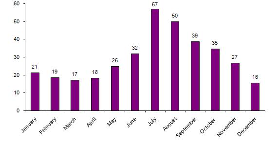 The data need to be interpreted a little carefully because of the uneven length of each month, but the seasonality of the occurrence worldwide is really striking. This peak is of course dominated by the weather conditions associated with the northern hemisphere summer – and in particular the combination of the summer monsoon in South and East Asia, the typhoon season in the NW Pacific and the Hurricane season in the Caribbean. So, at this point it is interesting to look at the long-range forecasts for each of these phenomena to see what might be in store.
So first, the monsoon in South Asia. This was of course continually in the news last summer due to the floods in Pakistan. Forecasts for the South Asia monsoon are issues by the Indian Meteorology Department. Their 2011 monsoon page provides an update on progress of the monsoon as it develops. Their long-range forecast (NB – pdf) is for an average monsoon for India:
IMD’s long range forecast for the 2011 south-west monsoon season (June to September) is that the rainfall for the country as a whole is most likely to be Normal (96-104% of Long Period Average (LPA)). There is very low probability for season rainfall to be deficient (below 90% of LPA) or excess (above 110% of LPA).
However, note that landslides are mostly triggered by short duration, intense rainfall (which this forecast does not really address) and that there is huge spatial variability in rainfall patterns. In other words, we will see hotspots of landslides occurring across South Asia, and there is no excuse for complacency. This monsoon forecast will be updated by IMD later this month.
At the moment I cannot find a long-range forecast for the monsoon in East Asia (anyone?), but much of this area has been in a state of drought. Heavy rainfall, and possible landslides, are being forecast for this week.
For the NW Pacific typhoon season, Tropical Storm Risk are forecasting a season that is also close to average. The City University of Hong Kong forecast is also for an average typhoon season, but with the caveat that landfalling events in both Southern China and Japan may be above average. The latter may be important in view of the vulnerability of the earthquake-affected areas of Japan to the impacts of intense rainfall.
For the Atlantic Hurricane season, Tropical Storm Risk are forecasting a season that is substantially above average, whilst the Colorado State University (Bill Gray) forecast is even more pessimistic, with indications that activity will be substantially above average in this basin.
As an aside, Ryan Maue at Florida State University maintains a wonderful web page monitoring global tropical cyclone activity. It is fascinating to see that worldwide the level of activity remains at historically low levels, for reasons that are far from clear. For updates on severe weather events around the world I recommend Jeff Masters’ Wunder blog in addition to Dan Sattersfield’s blog on this site.
4 June 2011
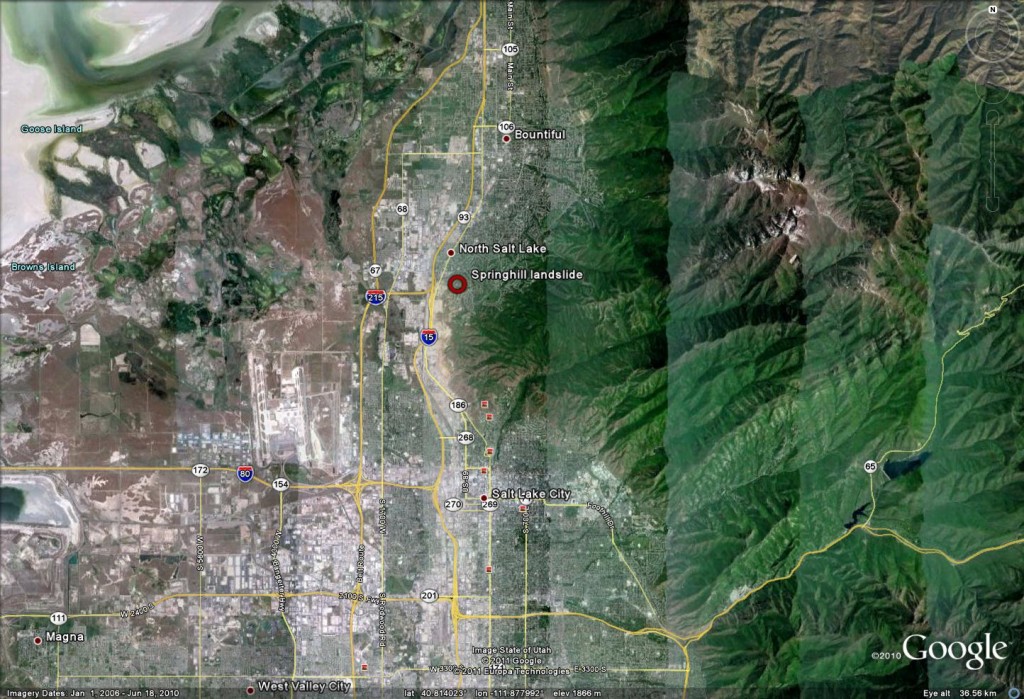
The Springhill Landslide in Utah – community action at its best
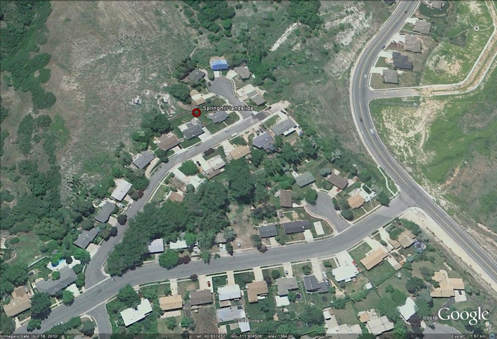
The Springhill neighbourhood of Salt Lake City in Utah is a smart, modern residential area. The Google Earth below shows the location – the grid reference of lat: 41.814; long: -111.878 should allow you to find the place for yourself on Google Earth:
At first sight the 2010 Google Earth image does not suggest that there are any major problems with the area that that is the subject of this post, though there are: some morphological features that would make one want to take a second look:
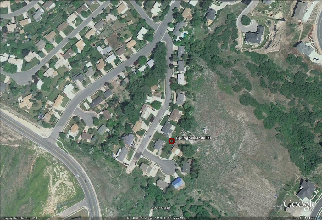
An intial closer, perspective look still makes it difficult to see much of a problem, but note the rather ominous light shaped linear feature just to the left of the blue roofed house at the top of the image, and the abrupt break in slope above and to the left of this. Hmmmm!:
Before we look at that potential crack, lets take a look at the road. I have now rotated the image so that the view is from the northwest. The road is now starting to look a little worrying because the pavement has clearly been repaired and the alignment of the margins of the highway appears to be distorted:
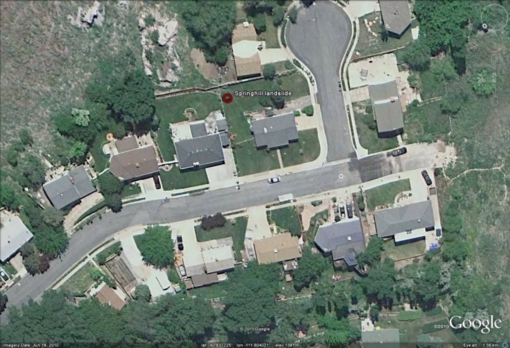
Let’s now take a look at the road togetrher with the possible crack that we identified earlier, and also that break in slope:
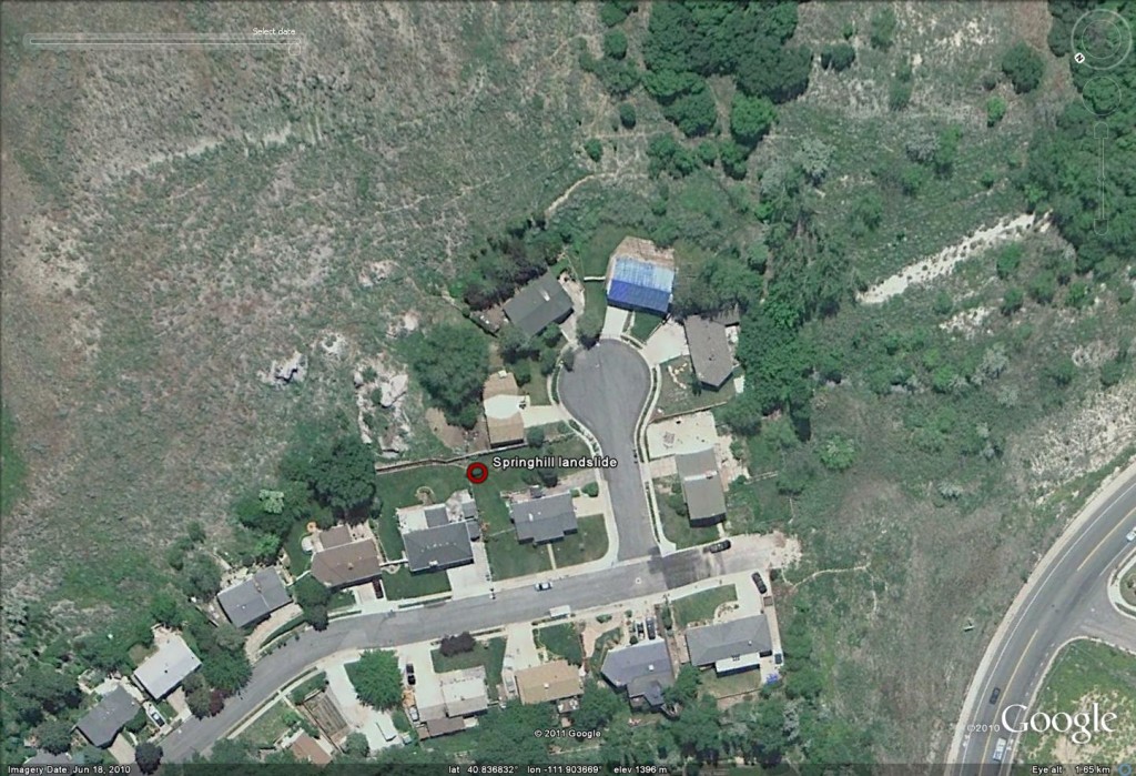
This is starting to look a little worrying in that the possible crack appears to be upslope of the deformed road. Let’s compare this view with one from 2006:
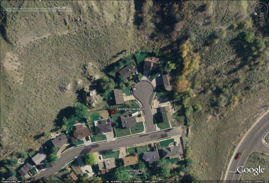
The road is clearly less distorted, though has been patched at each end and, more importantly, there is no sign of the feature that could be a crack.
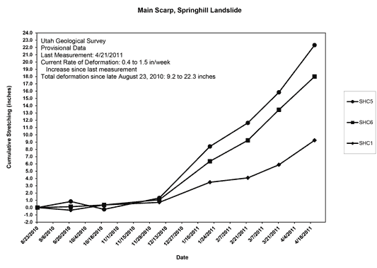
This area is the Spinghill Landslide, a slow-moving but destructive slide that is affecting this neighbourhood. Movement was first observed in the 1990s and has continued thereafter. Unfortunately at present the rate of movement is being recorded at as much as 1.5 inches (c.40 mm) per week. The impact on the properties is inevitably very serious. The Utah Geological Survey are monitoring the landslide and have a good technical update report online. Perhaps most interesting is a map of the measured movement as per GPS instruments – here the units of movement are inches, where 1 inch = 25.4 mm. Note this is just the movement since June 2010:
http://geology.utah.gov/utahgeo/hazards/landslide/springhill/images/springhill-aeriallg.jpg
And secondly, a graph of displacement against time:
http://geology.utah.gov/utahgeo/hazards/landslide/springhill/update.htm
Note that the movement rate has notably accelerated in the last few months. A news report from yesterday suggests that high rates of movement are still being recorded, and that the area is now being considered as being potentially uninhabitable. There is a quite excellent community blog with some very nice media reports about the landslide at http://www.projectspringhill.com/. This does a fine job of providing insight into the very human cost of such a landslide. The video below shows the demolition of the house with the blue roof:
http://www.youtube.com/watch?v=aTpVqRoSdl0
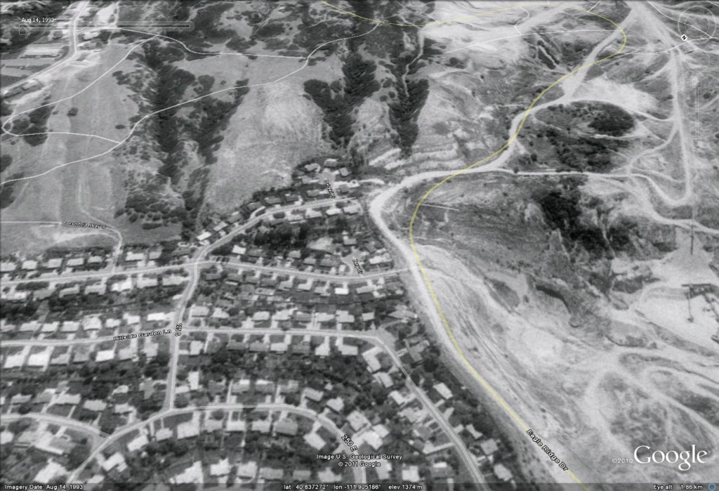
There can be little doubt that this event is a slow motion tragedy for those people living in the area. Finally, this Google Earth image is dated 1993; I have provided a perspective view. Whilst it wuld be impossible for a non-specialist to identify this site as being hazardous from a slope stbility perspective, to me there are enough morphological features present to hint at potential problems. I wonder why this site was not identified as being potentially problematic before subdivision?
 Dave Petley is the Vice-Chancellor of the University of Hull in the United Kingdom. His blog provides commentary and analysis of landslide events occurring worldwide, including the landslides themselves, latest research, and conferences and meetings.
Recent Comments