
1 August 2010
The floods in Pakistan
Posted by Dave Petley
In the UK the current floods in Pakistan are failing to gather the level of coverage that they deserve, although there has at least been some interest. The death toll is currently standing at over 1,100 people, with a million or more directly affected. Fortunately, the Attabad Dam appears to have avoided the worst of the rainfall, so far at least, and has remained intact, although the water level has risen. It seems likely though that this disaster will have slowed the plans for lowering the lake level – at least I hope so as this would be a very bad time to start blasting.
The worst affected area so far has been the area that most people know as Northwest Frontier Province, recently renamed to Khyber-Pakhtoonkhwa province. This is the area, which borders Afghanistan, is where the majority of the fatalities have occurred. This is a difficult region at the best of times, so expect some confusion about the true impacts over the next few days. Daily rainfall records for this area are available from the Pakistan Meteorological Department here. I have plotted the cumulative total rainfall for five stations in Khyber-Pakhtoonkhwa province – note that the average monthly rainfall for July for each station is included in the legend. The magnitude of this rainfall event is clear – compare the actual monthly totals with the reported monthly averages. The variation in monthly averages across the five stations looks odd, but is probably associated with the location of the mountain front, which provides a strong orographic effect.

The loss of life appears to have been the result of a combination of losses in the main rivers and their tributaries, flash floods in upper catchments, collapses of mud brick houses, and landslides. As is often the case in complex disasters of this type, it is difficult to unpick the balance of the losses, but it is clear that there has been at least one substantial landslide event. Several news agencies report a slide in the Olandar (sometimes spelt Ulandar) area of Besham (Bisham), which is said to have killed 60 people. There are also isolated reports of smaller fatal landslides. Given that this intense rainfall affected the Neelum valley and the area around Balakot, both of which were heavily damaged by landslides in the 2005 Kashmir earthquake, there is a strong likelihood that landsliding has been intense.
Meanwhile, the floods remain the main story. Such is the size of the Indus river that the flood crest has yet to be reached for many areas, as the Indus hydrographs show:
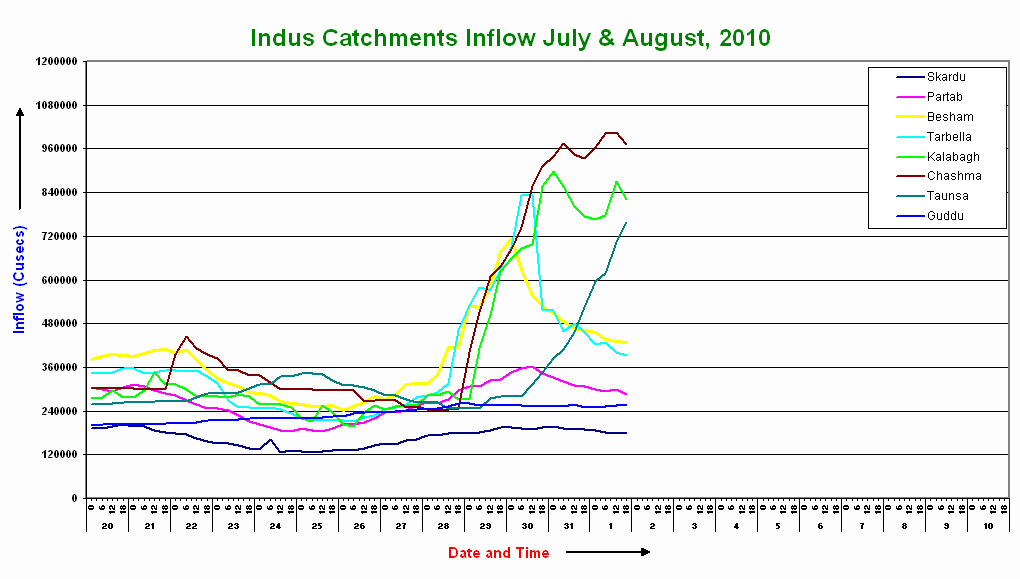
Note that the flood peak at Besham, which in the past month has had a very similar hydrograph to Attabad, has now reduced substantially.
Meanwhile, concern is now focused in two areas. First, as the flood waters (hopefully) recede in the upper catchments the full picture will emerge. It may well be that some of the more remote areas have been unable to communicate the magnitude of the disaster to date, so the toll could rise. There will also be concerns about the potential for disease associated with the flood waters. Second, there are now deep worries about the combined effect of the flood wave traveling down the Indus reaching Sindh Province, in southwest Pakistan, at the same time as another burst of rainfall. The most critical period appears to be from 4th to 7th August, when the director of the Pakistan Flood Forecasting Division, Hazrat Mir, is reported to have warned that “exceptionally high flood in the river and the expected rain were likely to gravely affect Pannu Aqil, Mithon Kot, Sehwan Sharif, Larkana, Dadu, Sukkur and Ghotki”. He is also reported to have added that there is an “urgent need to adopt precautionary measures. Low-lying areas, especially the ones in Sukkur and Ghotki, were likely to be affected the most. The FFD chief also expected flooding in Karachi, Hyderabad and Larkana because of the rain during this period”
 Dave Petley is the Vice-Chancellor of the University of Hull in the United Kingdom. His blog provides commentary and analysis of landslide events occurring worldwide, including the landslides themselves, latest research, and conferences and meetings.
Reports this morning in Australia say that most of the bridges in the Swat valley have been washed away.
To what calamaties I should cry? I am no more sensitive and destruction. Its part of our lives.
If anyone is interested in donating to help the locals in Pakistan get through this calamity, you should visit this site. http://www.guardian.co.uk/global/blog/2010/aug/02/pakistan-floods-live-updates
*If anyone is interested in donating to help the locals in Pakistan get through this calamity, you should visit this site. http://www.hidaya.org/social-welfare/disaster-relief/-pakistan-floods-2010
Due to heavey monsoon rains in Pakistan, about half of the Pakistan is under flood. Millions of people need help. They have no food and shelter. Please create awareness and try to help these needy people. You can give your suggestions to us at [email protected] , your little help can save a life.A message from http://www.forumpakistan.com , we request all the charity organization in the world to come in Pakistan and help in this hour of need.Thanks.
[…] from anticipation of a potential devastating earthquake in Nepal to a recognition that the flood waves travelling down the Indus were likely to cause mass flooding downstream. There is an emphasis on slow onset disasters too (e.g. […]
[…] from anticipation of a potential devastating earthquake in Nepal to a recognition that the flood waves travelling down the Indus were likely to cause mass flooding downstream. There is an emphasis on slow onset disasters too (e.g. […]